.jpg?timestamp=1714866543826)
the corner of Bellevue avenue and Avalon Parade - and just downhill from where creeks run through Angophora Reserve
The BOM's rain gauge statistics for the past week show 130 mm has fallen into the rain gauge at Mona Vale Golf course - and possibly a little more further north of the Bilgola Bends.
The valley of Avalon and Bilgola Plateau has been reminded this week that it was once a marshy floodplain called 'Priests' Flat' alongside the beach from Kamikazee corner to the mangroves of Careel Bay and that even though those water channels may now be funnelled into concrete pipes, they may still reappear during prolonged downpours of rain.
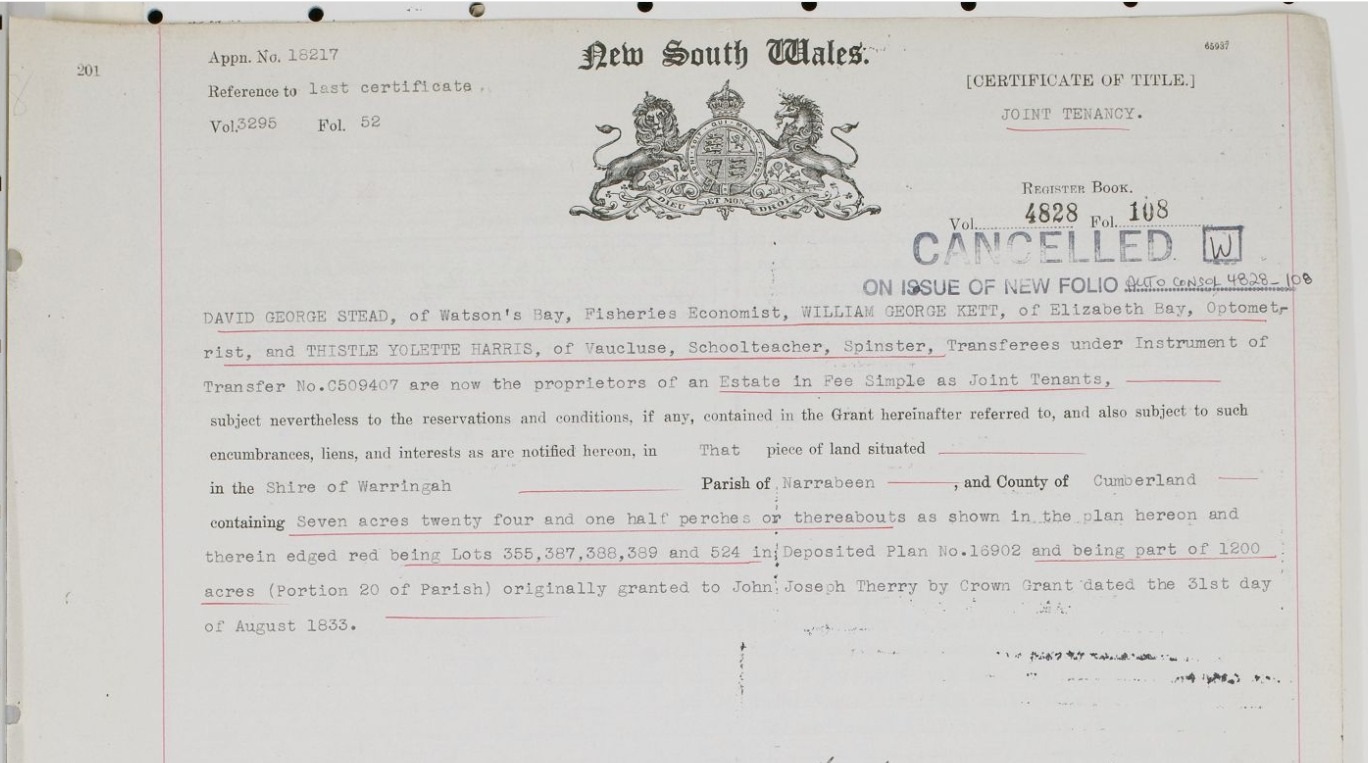
The NSW HRLV provides under Volume 4828, Folio 108 from when Angophora Reserve was handed to the community by A J Small - note the marked water courses, or creeks::
%20Vol%20Fol%204828-108.png?timestamp=1659822451523)
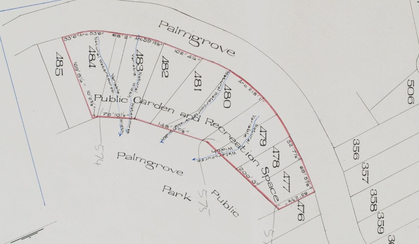
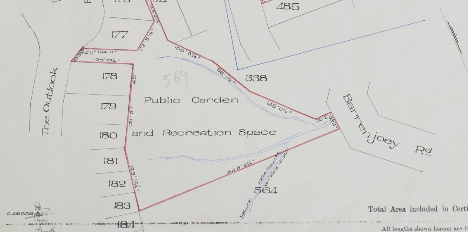
In February 1931 the formalisation of the dedicating the Bilgola Plateau parks from the same gentleman is recorded in Vol-Fol 4469-13, over 5 acres all up, which included some of the well-known Bilgola Plateau parks:
.jpg?timestamp=1714593544979)
.jpg?timestamp=1714594261697)
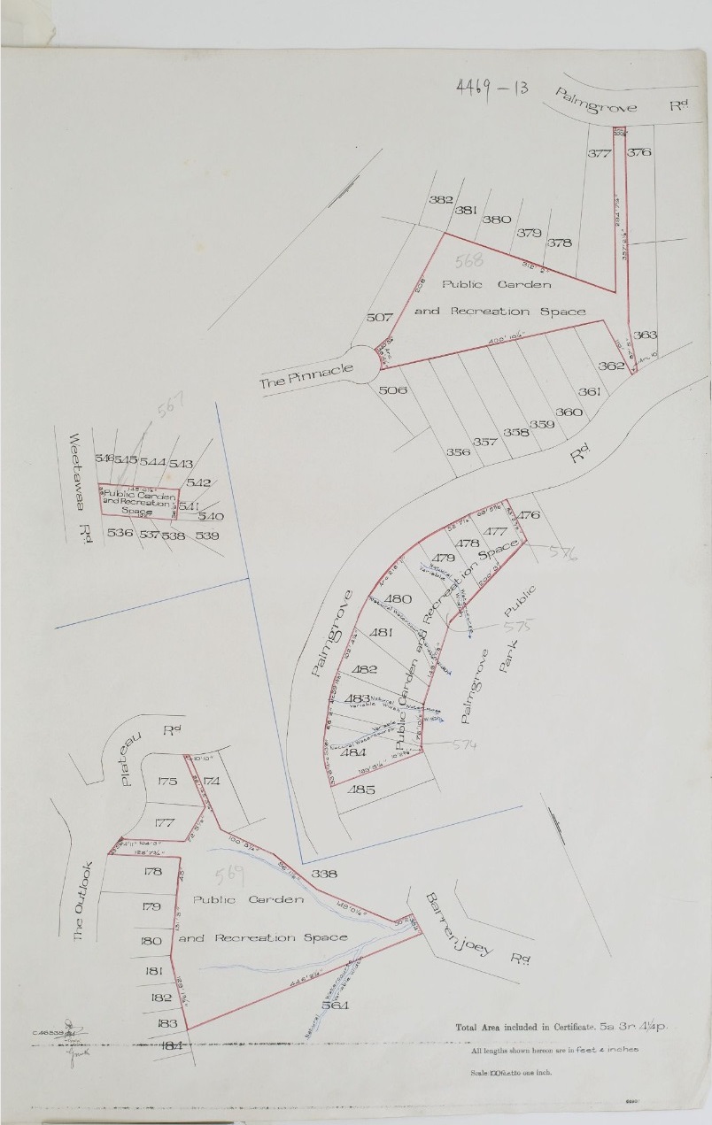
Note the creeks threading through these parks - the same is in the landscape at Angophora Reserve and Hudson Park (dedicated later as a public reserve, in 1957) during this era, as shown when that was formally gifted by A J Small and had the Wildlife Presrevation Society as Trustees, and in Dunbar Park, when that was gifted as well:
On May 2nd a waterpipe burst on the corner of Bellevue Avenue and Avalon Parade, carrying a plume of white and yellow sand and other matter all the way down Careel Creek and into Careel Bay.
The bay is home to Posidonia seagrasses, an endangered species, and as one of the slower growing species of seagrass, Posidonia australis can be particularly slow to recover from damage.
The Careel Bay Saltmarsh is one of the only large Sarcocornia dominated Saltmarshes in the Hawkesbury-Nepean Estuary. Mangroves act as a filter for pollutants, thus protecting the sea grasses and mudflats(symbiotic ecosystem relationships).
This drone shot taken by local photographer Tim Seaton shows the plume entering the waters and dispersing over the waters and their base.

Although Council, Sydny Water and the Avalon NSW Fire and Rescue team were quick to respond, the pavers that had been there for years are now gone. These photos were taken Saturday morning, May 4:
.JPG?timestamp=1714867459045)
.JPG?timestamp=1714867762448)
Too much rain, changes in temperature or ground conditions, tree roots, heavy traffic and construction work can all lead to breaks in water and cause water mains to burst.
Further north, at Careel Bay playing fields, which formally was part of the Careel Bay mangroves and then became a tip so the land could be reclaimed, and where road staff had cleared out the ditch over July 25-27 2022, the fact that this too is still actually a mangrove floodplain, and is fed by at least three old creeks encased in concrete pipes at Burrawong road and from atop Careel Head, has swept everything people keep putting into drains while blowing off grass and leaves, and the flow of dirt from the land, has filled this up again.
Pre July 25 2022:
.jpg?timestamp=1714868363767)
At work:
.JPG?timestamp=1714868295350)
This week (and why the Swamp Oaks thrive):
.JPG?timestamp=1714868421072)
.JPG?timestamp=1714868451006)
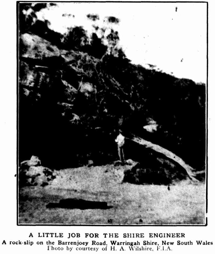
Further up the hill, on Whale Beach road, days of rain and water seeping through the landscape brought down about 8 tonnes of sandstone boulder - photos supplied:

This too is a recurring event - residents of decades would recall when a whole hillside slid down on to Barrenjoey Road just past 874 in the early 1980's. While this one, with a photo by John Stone, happened in November 1970 on Palm Beach road - this boulder was estimated to weigh 270 tonnes and took around a week to clear away:

Earlier than that one of Palm Beachs' earliest architects sent in some items to newspapers:


.JPG?timestamp=1714872896313)
Council Announces Intention To Progress One LEP For Whole LGA
Background
The community and councillors were assured by council staff that no environmental values would be sacrificed from any former council areas in the harmonisation of the Pittwater, Warringah and Manly LEPs and DCPs.
However, the Draft Conservation Zones Review proposed removing 3,613 properties from the former Pittwater Local Government Area’s Conservation Zones and making them Residential Zones, with their controls undefined. This contrasts with the loss of only one property with a Conservation Zoning from the former Warringah LGA. This scenario was, in fact, not harmonising zones across the new council area but aligning them with the former Warringah zonings, Cr. Korzy said.
Pittwater NSW MP Rob Stokes had also tried to reassure Pittwater residents about protection of its environment. In a letter to the Avalon Preservation Association of December 5, 2017, Mr Stokes discussed the introduction of Local Strategic Planning Statements. In it he said:
“The development of these statements will see councils and communities formulate the forward vision for land use in the local area - capturing and respecting the local characteristics that need to be preserved and articulating what local residents want in the future. This will include where and how any changes should occur.
These statements will be formally recognised in Legislation and reflected in councils’ Local Environment Plans and development controls. Councils will be able to tailor the statements to specify land use priorities on a ward by ward basis.”
However, the previous Northern Beaches Council chose not to utilise this process, opting instead for an LGA-wide LSPS. A ward based LSPS would have revealed the special characteristics of Pittwater and all other wards, and the differences between them. We can see the result of this in the Draft Conservation Zones Review, in which consultants have failed to recognise the importance of, for example, wildlife corridors and tree canopy. This would have a major impact in Pittwater - but also across the entire LGA.
Further, the previous NBC council made the decision to adopt one LEP across the LGA without any explicit discussion about the reasons for this or necessity to do so. At the November 27, 2018 meeting, councillors voted to accept the Local Environment Plan Review and one LSPS.
However, the report from staff did not mention the fact that there is no legislation that requires one LEP or any ministerial directive to that effect either. This issue was never placed before councillors or the community, and we were told that the state government required us to introduce one LEP.
The NSW Government changed the name of Environment Zones across NSW to Conservation Zones. The new names commenced on 1 December 2021.
It was stated at the time this change was of name only. Land uses that were currently permitted and prohibited in the environment zones would continue once they are renamed conservation zones. Only the name of zones is changing.
The Government stated; ''By renaming these zones to reflect the ‘conservation’ land use function more clearly, the focus, purpose, and intent of these zones is clearly signalled. The purpose is to conserve the environmental values and qualities in areas where this land use zoning is applied.
The naming also aligns better with the objectives of the zones as being about conservation.''
There were now 4 types:
- Zone C1 – National Parks and Nature Reserves (previously E1)
- Zone C2 – Environmental Conservation (previously E1)
- Zone C3 – Environmental Management (previously E1)
- Zone C4 – Environmental Living. (previously E1)
Northern Beaches Council conducted a Conservation Zones Review in 2022, that was publicly exhibited, proposing the former Pittwater Area lose thousands of C4 Conservation Zones blocks, compared to 54 in the former Manly and just one in the former Warringah Council LGA.
Staff received 935 public submissions regarding the review, 60 per cent of which were from residents of the former Pittwater area.
In Pittwater, the former C4 zoning for the Pittwater Council LGA allowed low impact developments (generally single dwellings) in areas with special ecological, scientific or aesthetic value while in Manly, blocks of flats were allowed in the C4 zone.
Planners told councillors they estimated that in the former Pittwater LGA, 3,613 properties would move from a C zone to an R (residential) zone, and 1,328 from an R zone to a C zone, resulting in an overall loss of 2,285 properties from C zones.
Most residents are aware of massive excavations from boundary to boundary and multiple storeys down in E4 zones - Environmental Living Zones now known as C4 for Conservation Living Zones - across the former Pittwater Local Government Area. These include sites at Palm Beach and Whale Beach, Avalon, Bayview and Church Point - where massive homes are built, sometimes up to six storeys down the block.
Councillor Korzy introduced a Motion at the February 2023 Meeting. The Motion called for the briefing to include reference to excavation, tree removal/retention, protection of endangered ecological communities, hard surface to landscape ratios, and other relevant matters. Cr. Korzy also asked for it to discuss how compliance with conditions of consent and relevant legislation is assessed and enforced in these zones.
''Finally, I asked about options for protecting the environment in our C4 zones as part of the new Local Environment Plan and Development Control Plan currently being drafted for the whole Northern Beaches Local Government Area. The new LEP and DCP are required in councils amalgamated in 2016.'' Cr. Korzy stated
The Pittwater LEP states that its particular aims include: “to promote development in Pittwater that is economically, environmentally and socially sustainable … (and) “to protect and enhance Pittwater’s natural environment and recreation areas”.
Objectives of the E4 Environmental Living Zone were then defined as:
- To provide for low-impact residential development in areas with special ecological, scientific or aesthetic values.
- To ensure that residential development does not have an adverse effect on those values.
- To provide for residential development of a low density and scale integrated with the landform and landscape.
- To encourage development that retains and enhances riparian and foreshore vegetation and wildlife corridors.”
The DCP provided detail on how these objectives should be achieved. It includes extensive controls related to the natural environment, including for specific ecological communities and 16 locality specific controls.
Amongst them are numerous controls on development in environmentally sensitive sites, such as:
“Development shall not have an adverse impact on Pittwater Spotted Gum Endangered Ecological Community.”
For land adjoining bushland reserves it states that: “Development shall not result in a significant loss of canopy cover or a net loss in native canopy trees.” And for heathland/woodland vegetation: “Development shall not reduce or degrade habitat for locally native species, threatened species, endangered populations or endangered ecological communities.” It also explicitly lays out Pittwater’s well-known 60:40 ratio for the building envelope on Pittwater’s C4/E4 zones, stating for a number of suburbs that: “The total landscaped area on land zoned R2 Low Density Residential or E4 Environmental Living shall be 60% of the site area.”
Experts who reviewed the Biodiversity Planning Review paper stated it should be opposed as such a huge potential loss of conservation zones represents the most serious incursion into the existing Pittwater LEP/DCP rules. These guidelines have contributed to the protection of Pittwater’s character, landscape, and scenic quality to date.
In total, the former Pittwater would have had 7,447 properties zoned C3 or C4 and 9,347 properties in residential zones.
The move from C4 to Residential would result in more development in these areas and a huge loss of natural landscapes including canopy. The rezoning from C4 to Residential would also trigger the application of the July 1st 2022 amended NSW Housing SEPP to the newly created Residential zones.
Under the changes made to the State Environmental Planning Policy (Housing) 2021 all seniors living, including independent living unit developments, will be allowed in R2 Low Density Residential zones. The building height will also change, allowing up to 9 metres, excluding any basement works.
It's also worth noting that under the Council's Local Housing Strategy the then NSW Department of Planning told the Council it must proceed with planning work that will lead to rezoning of one or more of the following as outlined in its LHS to compensate for housing not delivered by the Ingleside precinct:
- One of the following Centre Investigation Areas for Brookvale, Dee Why, Manly Vale or Narrabeen;
- Two or more of the Housing Diversity Areas centres; and/ or
- other proposed rezonings in the LGA that have arisen since the preparation of the LHS that will enable delivery of substantive and new housing supply.
The planning proposals for one or more of these alternatives were required to be submitted to the NSW Planning Department for Gateway determination by or before December 2022.
Further, the Council is required to submit proposal(s) for two or more of the Centre Investigations Area are to the Planning Department for Gateway determination to facilitate dwelling delivery within the 2021 to 2026 period.
Council was also required to expedite the following LHS actions under Priorities 2 and 5 to ensure housing supply, diversity and affordability outcomes are secured before 2026:
- Planning analysis and LEP updates for Brookvale, Dee Why, Mona Vale, Manly Vale and Narrabeen that do not reduce the permissibility or density of existing permissible uses.
- Annual reporting of development by centre to track yields and housing mix.
- Adoption of a social and affordable housing target.
- Continue to implement council’s affordable housing contribution scheme (AHCS).
- Review and seek lower parking requirements for boarding houses for R3, R4 and B4 sites in centre investigation areas.
Council's LHS Centre investigation areas identified Brookvale, Dee Why, Mona Vale, Manly Vale and Narrabeen along the existing B-Line as centre investigation areas in the medium term, and Forestville and Beacon Hill in the longer term, subject to a future B-Line route (future B-Lines along Warringah and Mona Vale Roads).
Housing diversity areas identified through the Council's LHS were Avalon, Newport, Warriewood, Belrose, Freshwater, Balgowlah and Manly as areas to support housing diversity in the form of dual occupancies, seniors housing and boarding houses.
In July 2018 the NSW Government introduced new planning controls through the Low-Rise Medium Diversity Housing Code (the Code) under State Environmental Planning Policy (Exempt and Complying Development), which also applied to the NBC LGA.
The Code allows for the development and subdivision of dual occupancies; multi-dwelling houses (including terraces), manor homes under a fast track complying development approval process where those land uses were currently permitted with development consent from Council.
This approval can be issued by a private certifier within 20 days if the application complies with requirements in the Code.
Residents already know the former Pittwater LGA is under increasing environmental pressure. This trend has seen people building way over their 60 percent of land area, needlessly removing trees and exceeding existing height limits with variations being permitted.
There have also been a number of proposed developments out of keeping with Pittwater. One still before the Land and Environment court, with hearing dates set for later in October, seeks to build flats and develop the whole block in an area where this would ruin the local amenity at Palm Beach.
There have been ongoing calls for a Heritage Listing for the whole of Pittwater since the plans were first made public.
Professor Richard West AM, President of the Palm Beach-Whale Beach Association, which has as its main aim to preserve the unique environment in which we live, has echoed other residents associations which state these changes represent a threat to Pittwater.
Prof. West told Pittwater Online then that 'special consideration should be made to preserve these qualities'.
These zonings will feed into the upcoming, single Northern Beaches Local Environment Plan, despite it having been pointed out again in 2023 that Pittwater could retain its own LEP, something which had been spoken of even before Pittwater was forcibly amalgamated with Warringah Council.
A single LEP would regulate development for the whole council area. So for those wanting to protect the scenic bushland habitat, it was important to read the multiple documents made available and let the Council know what you thought.
The Council wanted to know if residents agreed with the approach and criteria used in the review to identify and map core habitat areas, biodiversity corridor areas, threatened ecological communities, and threatened flora and fauna species habitat.
Conservation zones, previously called Environmental zones in the former Pittwater LEP, “are used to protect and conserve areas with special environmental values or where there are known hazards eg bushfire, (and) coastal inundation”, planning staff noted in their motion to place the draft on exhibition.
The four conservation zones in the new LEP align with those identified and renamed by the NSW Department of Planning and Environment as follows:
- C1 National Parks and Nature Reserves - existing and newly proposed national parks, nature reserves and conservation areas - as identified and agreed by the NSW government.
- C2 Environmental Conservation - for areas of high ecological, scientific or cultural values.
- C3 Environmental Management - Special ecological, scientific, cultural or aesthetic attributes or environmental hazards/processes.
- C4 Environmental Living - special environmental or scenic values; low impact residential development.
The challenge for Council staff has been that four LEPs are currently operational across the Northern Beaches Council area and the state government required that they be 'harmonised' after the forced amalgamation of the former Manly, Warringah and Pittwater councils. (ie Pittwater’s LEP; Manly’s; Warringah’s; and a second one in that former council area for land where zoning was never finalised by the NSW government).
Alike the Rates Harmonisation of the forcibly amalgamated former Councils that saw an increase for Manly and Pittwater implemented from July 1st 2022, and a reduction for the former Warringah area, despite an amendment to the Local Government Amendment Bill 2021 which allowed up to eight-years to harmonise rates for councils that were amalgamated in 2016, and which had been preceded by Warringah Council's seeking approval from IPART in 2014 for a cumulative increase of 26.2 per cent over four years 9and was instead allowed an increase at 19.7 per cent), the former council area that will be impacted most by an 'LEP harmonisation' would be Pittwater and the Pittwater environment,prioor to the late 2023 announcements under the new Minns government.
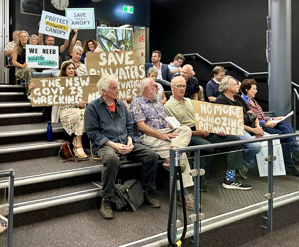
Pittwater residents at February 2023 Council Meeting
Previous reports during the council consultation:
- Pittwater Community Forum: A Discussion On How To Save Our Area - July 2022, Issue 548
- From The Council Chamber August 23, 2022: Conservation Zones review - Issue 552
- Conservation Zones Review Has Potential To Facilitate Medium Density In Previously 'Environmental Living' Zones - October 2022, Issue 557
- Conservation Zones Review Residents Forum: Resolutions Call For Shift In Criteria Applied, For Keeping Pittwater's Green-Blue Wings Intact, For State Election Candidates To Declare Their Position On Pittwater Community's Stated Expectations - October 2022, Issue 559
- NBC’s Conservation Zones Review - What’s It All About? - November 2022, Issue 562
- Saving Pittwater From The Chainsaws: Community Forum At Warriewood - Thursday February 2nd 2023, At 7pm + 'Concreting Our Coast: The Developer Onslaught Destroying Our Coastal Villages and Environment' Report Released - January 2023, Issue 568
- Pittwater Planning Could Be Covered By Its Own LEP: Greens Lawyer - February 2023, Issue 570
- Who Wants To Keep All Pittwater's Conservation Zones?: Cr. Korzy Motion for February 2023 Council Meeting - February 2023, Issue 573
- From The Council Chamber - February 28, 2023 By Miranda Korzy, Pittwater Greens Councillor - March 2023, Issue 574
- A Huge Win For Pittwater's Environment! Pittwater To Keep Its Conservation Zones - December 2023
Transport Oriented Development Begins
