Environment News: March 2025

March 1 - 31, 2025

Week Four March 2025 (March 17 - 23)

Just Two Trees

From award winning film maker Bruce Walters (Avalon Now), Just Two Trees is a powerful expository that follows the ongoing fight of impassioned Pittwater locals to save two majestic gum trees from contractor's chainsaws.

In May 2024 Northern Beaches Council informed residents of Ruskin Rowe, in Avalon NSW, of its intention to remove four Flooded gums which form part of the street's historic avenue of trees. A large branch had fallen from one of the trees earlier in the year, causing damage to a resident's car that had been parked on public land in the quiet cul-de-sac.

This sparked a chain of events that ultimately lead to the removal of two of the four trees, and a month-long blockade of the remaining two by local residents and community groups. At the very core of the dispute is the notion of the risk versus the benefits of a community's unique tree canopy.

Watch the film below.

Background in 2024 reports:

Council's Draft Tree Management Policy Open for Feedback

The Northern Beaches Council is inviting feedback on its new draft Tree Management Policy which the council states ‘aims to strengthen tree assessment and protection requirements and expand the local green links between natural areas’.

‘The draft harmonises the former council's policies and provides a consistent and strategic approach to tree management across the area.’ a release by the council says

Northern Beaches Mayor Sue Heins encouraged the community to have their say on the draft Policy  

“This initiative underscores our commitment to maintaining and enhancing the region's exceptional tree canopy coverage, which with an estimated 12 million trees is among the highest for an urban council in Australia.  

"Our tree canopy is a vital part of our local environment, helping to keep temperatures down, providing important habitat, and is highly valued by our local community.

The council states the new draft policy provides: 

  • a framework that supports the sustainable management and retention of safe and healthy trees 
  • supports the management of public trees through succession and new tree planting, along with proactive and reactive maintenance programs
  • preferences locally occurring native species for new plantings
  • prioritises alternative options before pursuing the removal of trees

For more information and to provide feedback, the community can visit the Your Say project page. 

The policy will be on exhibition from Monday 24 February 2025 to Sunday 30 March 2025.

Visit; https://yoursay.northernbeaches.nsw.gov.au/ 

Chlamydiosis discovered in South West Sydney Koalas: public kept in the dark 

March 21, 2025

Koalas in one of the few chlamydia free populations in NSW have been found with the disease that causes infertility, blindness and increases susceptibility to dog attack and other threats. The South West Sydney Koala population were discovered to be infected with chlamydiosis in September 2024 and marks a serious challenge to the ongoing viability of the population that is under extreme threat from road expansions, urban expansion and other developments. The Government has known this for months but kept the public in the dark, states Greens MP and spokesperson for the environment Sue Higginson.

The disease was found in two Appin koalas that tested positive, both of which had been hit by cars.

Save Sydney Koalas said on Friday; ''but no action has been taken to make safe passageways for koalas across roads like Appin Rd

These koalas are still unprotected from habitat loss and fragmentation which are key drivers to stress and chlamydia.'' 

The Sydney Basin Koala Network stated:  · 

''This is bad news. But beyond the headline:

1. No other wild koalas in Appin tested have it

2. It has not reached Campbelltown and Sutherland''

Ms Higginson said on Friday “I am devastated but not surprised about this tragic find in the Koala population of South West Sydney, this marks a horrid and significant further challenge for the ongoing survival of koalas in the wild in NSW,”

“It is extremely concerning that the NSW Government has not made this tragic news public until now, especially considering the continuing delay in establishing the promised Great Koala National Park. 

This news has broken the day after the Minister for the Environment criticised the Parliament for questioning the Government's commitment to transparency and their integrity on the promise to do more to stop koalas edging any closer to extinction,”

“While koala habitat is destroyed and logging continues at a higher intensity in the Great Koala National Park than in recent years, the Government should have come clean about this renewed threat to the critical South West Sydney Koala Population. Premier Minns’ program of expanded roads and fast tracking approvals through the planning system for new residential development is already placing too much pressure on this koala population, and now the community has to discover this new threat after the Government has kept this from them for some 6 months,”

“This is not the first time in recent months that the NSW Government has not been forthright with the people of NSW on environmental matters. When faecal matter was washing up on Sydney beaches last year, it took several weeks for the presence of human waste to be officially confirmed, despite scientists testing the materials and identifying the human waste quickly,”

“It is frankly disturbing, that the day after going on the defensive for their lack of honesty and transparency, this Labor Government has again been found to be lying by omission and refusing to be truthful about matters that are of significant concern to the State,”

“It is clear that Koalas in NSW are still on the path to extinction here in NSW, and the promises by Premier Minns to stop this don’t seem to be worth the paper they were written on. 

We had a chance to manage koalas to recovery, but the Minns Government continues to manage our poor koala to extinction. The Government must once again be asked, why has this information been kept secret, and why are we still allowing the Great Koala National Park to be industrially logged almost two years after the Government promised it would end,” Ms Higginson said.

The NSW Government in a release statement said:

The Department of Climate Change, Energy, the Environment and Water (DCCEEW) is taking action to support the koalas of south-western Sydney from the threat of chlamydia after two rescued koalas tested positive for the disease.  

The koalas were rescued in Appin last year with injuries suggesting they had been hit by a car. Once in care, further testing revealed chlamydia was present in both koalas. One koala was treated, while the other had to be euthanised. 

As a result, immediate actions were taken including:  

  • working with local rehabilitators and vets to improve biosecurity; 
  • organising a survey and testing of wild koalas in the vicinity of where the chlamydia positive koalas were found.  

Subsequent testing has found no further evidence of disease in this south-western Sydney koala population.  

DCCEEW will continue to monitor and expand testing in the coming months, using drones east of Appin to locate koalas and collect their scats for chlamydia testing. Routine testing will also continue for every koala that comes into care.  

To ensure the ongoing health of koalas in the region and prevent the spread of the disease, the University of Sydney has been commissioned to develop a Chlamydia Management Strategy, due to be completed later this year. 

A workshop in April will bring together stakeholders involved in koala conservation in south-west Sydney to seek their input to help develop the strategy. 

The NSW Government has invested around $88 million in south-western Sydney koalas. This includes almost $27 million to create koala-friendly crossings, $4.5 million to establish a koala care centre and more than $48 million to help establish a new national park along the Georges River. 

The development of the Chlamydia Management Strategy is funded under the NSW Koala Strategy. 

Department of Climate Change, Energy, the Environment and Water Director Threatened Species and Ecosystems, Alison Schumacher stated:

“Chlamydia is present in many koala populations, affecting them in different ways. Understanding and addressing these impacts is critical to ensure ongoing conservation efforts.  

“We responded to this incursion quickly and will continue to improve our understanding of the most effective interventions.   

“We are working closely with our partners to manage this disease and protect this much-loved species.” 

However, where those $27 million worth of koala crossings actually are remains a mystery as none whatsoever are currently in place across NSW, despite 20 years of talk about these being installed where roads have cut through their historic endemic ranges.

Koala at Mona Vale, 1958 - now locally extinct. Visit Bayview Koala Sanctuary

New walking track linking Middle Head–Gubbuh Gubbuh and Georges Head Now Open

A new walking track, linking Middle Head–Gubbuh Gubbuh and Georges Head, is now open in Sydney Harbour National Park showcasing the area’s military significance and providing visitors an iconic scenic harbour experience.

The 3km walking track immerses visitors in over 220 years of Sydney’s defence history with a collection of restored defence structures, dating from 1801 to the Vietnam War, and installations, including signage and digital animations, bringing to life the site’s rich past.

This $9.5 million project, implemented over six years, delivers the missing link between the headlands, and connects to Chowder Bay and the Bondi to Manly Walk, creating a seamless walking experience for visitors.

Visitors can walk through restored World War II twin 6-pounder gun casemates and military fortifications such as the Inner and Outer Defensive Ditches, which were carved around the headland to protect fortifications from land-based attacks.

The track includes several new lookouts such as ‘The Belvedere’ and a new bridge across the large Outer Defensive Ditch, offering stunning views across Sydney’s foreshore and inner harbour.

Visitors can also see the re-furbished 19th century former NSW School of Artillery buildings sitting as they would have 150 years ago.

The Engine Room, located at the Outer Fort at Middle Head, was re-purposed in the 1950’s to prepare Army officers for possible capture and interrogation during the Malayan Emergency and later Vietnam War and holds the notorious ‘Tiger Cages’.

Chad Weston, Manager Sydney North Area NSW National Parks and Wildlife Service, said:

“Middle Head and Georges Head have been part of Sydney Harbour National Park since 1984, but until now, they have never been connected via walking tracks to other harbourside reserves.

“This major new infrastructure project has significantly improved visitor accessibility and safety, and those who appreciate history will be impressed with how some of Sydney’s most significant historic fortifications have been conserved.

“New interpretation signs have also been installed at key points along the new walking track that help bring to life the layered history of the site.”

Aerial shot of Obelisk battery observation tower and casemate, looking toward Obelisk Beach, Sydney Harbour National Park. Image Credit: DCCEEW

Coastal Dynamics 2025 Conference

University of Sydney's Prof. Andrew Short has been announced as the 2025 Coastal Award winner and has confirmed his participation in Coastal Dynamics 2025, where he will give a presentation.

The 10th edition of the Coastal Dynamics Conference will be held from 7th – 11th April 2025 at the University of Aveiro, Portugal.

The conference theme is “Living with a Dynamic Coast”, and invites scientists and experts from all over the world conducting research on the dynamics and changes of the coastal systems to contribute with their insights and research results. Approaches include field (remote and in-situ) observations, laboratory experiments, theoretical formulations, and numerical simulations.

Proposed general topics include:

Beach and dune morphdynamics

  • Coastal management and risk assessment
  • Coasts and climate change effects and responses
  • Estuarine and coastal lagoons’ processes
  • Hydrodynamics (waves, tides and surges)
  • Nourishments and nature-based interventions
  • Observations, monitoring and modelling
  • Sediment dynamics, and sediment-biota/plastics interactions

Proposed specific topics for the 2025 edition area:

  • Coral and nature-based reefs: hydrodynamics and morphodynamics
  • Coastal wetlands for coastal resilience and climate adaptation
  • Dynamic islands
  • Shoreline evolution modelling
  • Participatory research & citizen engagement for coastal sustainability
  • Emerging technology for surfzone observations
  • Restoring river-coast dynamics: barriers and enablers for nature-based interventions
  • Navigating coastal microplastic: fate and transport

Coastal Dynamics started in 1994, being a sister conference of the Coastal Sediments Series, which started in 1977. The international Coastal Dynamics conference series is one of the most important meetings for scientists in the fields of nearshore dynamics and coastal evolution. The 1st edition was held in 1994 in Barcelona. Since then, conferences were held in Gdansk, Poland (1995); Plymouth, UK (1997); Lund, Sweden (2001); Barcelona (2005); Tokyo, Japan (2009); Arcachon, France (2013); Helsingor (2017); and Delft (2021).

Recent research and applications concerning coastal waves and currents, interactions between wind, water, sediments and eco-systems, and morphology changes in different morphological environments (with and without structures) such as sandy, rocky, and muddy coasts, inlets, and estuaries are welcome.

For more information about Coastal Dynamics 2025, please visit their website

Smoky mouse reintroduced to South East Forest National Park feral cat and fox-free area

On Monday March 17, 2025 the NSW Government announced The critically-endangered smoky mouse was recently reintroduced into South East Forest National Park, making a return to an area where it has not been seen since the 1990s.

The smoky mouse is the first threatened species to be reintroduced into the Nungatta Feral Predator-Free Area constructed in the national park. Almost 50 individuals have been released into the area with up to 120 to be released into the area each year.

The smoky mouse is the first of up to nine locally extinct species to be reintroduced to Nungatta including the long-footed potoroo, eastern bettong, eastern quoll and New Holland mouse.

The project is turning back time for this critical area of forest, bringing back the pre-European assemblage of mammals and restoring ecosystem health. It is set to be a shining example of biodiversity restoration which, in years to come, will be a special place for visitors to the South East Forest National Park.

The smoky mouse reintroduction is a collaboration between the NSW National Parks and Wildlife Service (NPWS), the NSW Government’s Saving our Species (SoS) program, the National Threatened Species Institute and University of Canberra.

Listed as critically endangered in NSW, the smoky mouse is a small native rodent about 2-3 times the size of the introduced house mouse. It was first recorded in NSW in 1993 near Mt Poole, in Nungatta State Forest.

There is a population of smoky mice in Kosciusko National Park and a small number are still recorded in the Nullica area of South East Forest National Park. They are also present in a small number of sites in western and eastern Victoria, but have not been seen in southern Victoria in a long time.

The smoky mouse’s numbers have significantly declined due to predation by feral cats and foxes, habitat loss, inappropriate fire regimes and infestation of understorey shrubs with the introduced root rot fungus Phytophthora cinnamomi.

The Nungatta feral cat and fox-free area was established by NPWS as part of a network of 10 feral cat and fox-free areas. Once all sites are established, almost 65,000 hectares of national park estate will be free of feral predators. This is an essential part of its threatened species strategy and commitment to zero extinctions in NSW national parks.

The reintroduced smoky mice are part of a captive breeding program started in 2016, supported by the SoS program.

More information regarding feral predator-free areas is available here: nationalparks.nsw.gov.au/conservation-programs/feral-predator-free-project.

David Kelly, Manager Threatened Species NSW National Parks and Wildlife Service stated:

“Nungatta is a special place, the first feral cat and fox-free area in the tall forests of South East Forest National Park.

“The return of the smoky mouse is the first step in a major ecosystem restoration project that will see locally extinct species reintroduced, and existing local populations bounce back from decline.

“Over the next few years, the NSW Government will reintroduce the eastern quoll, long-footed potoroo, eastern bettong and more, all of which play critical roles in the ecosystem.

“This project is about saving endangered species and thereby restoring ecosystem health.

“In the future, once all these reintroductions are complete, I look forward to South East Forest National Park being an even better place to visit than it is already.”

Smoky mouse (Pseudomys fumeus) released into enclosure, Nungatta Feral Predator-Free Area, South East Forest National Park. Image Credit: DCCEEW

Giant Sunfish washes up on WA Beach

A dead sunfish washed ashore on a beach near on Lowlands Beach between Albany and Denmark, about 450 kilometres south of Perth, this week. 

These photos, taken by Jason Fowler, who is also a marine ecologist, said he was surprised to see one this far south.

Mr Fowler said this fish's death could be linked to recent marine heatwave events along WA's coast.

"We had a big bleaching event at Scott Reef in the northern Kimberley and then that big blob of hot water moved down the coast, bleached the West Kimberley corals, and it moved down into the Pilbara," he told the ABC.

A marine heatwave has been blamed for a mass fish kill event in which 30,000 fish washed up at Gnoorea Beach in January and the bleaching of deep corals at Ningaloo Reef for the first time on record.

Mr Fowler said the species were very sensitive to temperature changes.

"My guess is that the sea surface temperatures would have had a lot to do with this animal dying and washing ashore," he said.

Mola Mola, also known as the Ocean Sunfish, are the largest bony fish in the world. These beautiful creatures can grow to over 3m in diameter and weigh up to 2 tonnes.

In June 2023 nine slender sunfish were found on Frenchman Bay and Goode Beach in Albany prompting an investigating by the Department of Primary Industries and Regional Development.

Around the same time a giant was found washed up in South Australia prompting media coverage across the world.

Photo: Jason Fowler

New skink a second unique species for Scawfell Island

March 18, 2025

A new skink species, the Scawfell Island Sunskink (Lampropholis Isla), has been discovered by JCU Associate Professor Conrad Hoskin. Photo: JCU

A James Cook University biologist has discovered a new species of lizard on Scawfell Island, a remote island 50km east of Mackay in north Queensland.

Associate Professor Conrad Hoskin named the new skink species the Scawfell Island Sunskink (Lampropholis isla) after discovering it with Queensland Parks and Wildlife Service (QPWS) and Partnerships Rangers.

The newly discovered skink has distinct orange markings on its sides and inhabits rocky, rainforest gullies.

“It is exciting to find a new species in Australia in this day and age, and particularly exciting to find a beautifully coloured species entirely restricted to this paradise of an island,” Assoc Prof Hoskin said.

Scawfell Island, in the South Cumberland Islands National Park, came to fame in 2023 with the naming of a spectacular leaf-tailed gecko also unique to the island.

Assoc Prof Hoskin said surveys on surrounding islands in the South Cumberland Islands National Park failed to find the sunskink and leaf-tailed gecko, making Scawfell a stand-out among Queensland islands for its number of unique vertebrate species.

“A handful of other islands have one endemic vertebrate species, including K’gari, Hinchinbrook and Magnetic Island, but no other island is known to have two until now,” he said.

“So, it's great to know about these special places like Scawfell Island that may be tiny but have really unique wildlife that we can now be careful to look after.”

Now that the skink has been formally recognised Assoc Prof Hoskin said steps can be taken to help ensure its conservation moving forward.

“Until you discover it it’s not on anyone's radar, and it takes the discovery and the naming of it before you can start conserving it” he said.

“We don't recognise any particular threats to them at the moment and there's good numbers. They might be doing quite well now, but anything that's just found in one spot you’ve got to be keeping a close eye on.”

Senior QPWS Ranger for the Whitsundays region Sarah Jordan said it’s important we understand the biodiversity of our island national parks.

“The recent discovery of these endemic species on Scawfell Island highlights the intrinsic value of the island national parks that we manage,” she said.

“Our conservation efforts focus on safeguarding these unique ecosystems against potential threats”.

The paper is published in Australian Journal of Taxonomy and is available online here.

Grants open for the $81 million FOGO fund

March 21, 2025

$31.4 million in grants is now open for councils to support the roll out of food organics and garden organics (FOGO) recycling. Run by the NSW Environment Protection Authority (EPA), the Go FOGO grants will help local councils fast-track their transition to FOGO and tackle the state’s waste crisis.

Greater Sydney is on track to run out of landfill space by 2030. With food and garden waste making up about a third of red-lid bins, diverting food and garden waste is a critical step in easing pressure on landfill.

The NSW Government became the first state to mandate FOGO statewide and backed it with the $81 million FOGO Fund. This $31.4 million round of the Go FOGO grants, is one part of the full package.

The government states these grants will support councils to move all households to FOGO recycling by July 2030.

Councils can access this grant funding based on the number of households making the transition to FOGO, with extra support for high-density areas. Grants include a flat rate of $25 per apartment, and $50 per house, if there is no existing organics collection.

The grant round announced today is in addition to the following support:

  • $1.9 million awarded to Sutherland, Blue Mountains, Blayney and Parramatta councils to introduce new FOGO services, under Round 3 of the Go FOGO grants
  • $2.1 million allocated to 14 projects to help organisations like Accor Hotels and TAFE NSW to reduce and separate food waste, under Round 2 of the Business Food Waste Partnership grants
  • $340,000 available for councils with existing services to do more community education.

Since November 2022, $18.6 million across three Go FOGO rounds has helped 23 councils deliver the changes to almost 680,000 households. The money has covered education, staff, audits and essential infrastructure like bins and kitchen caddies.

Councils who want to apply for the Go FOGO and Scrap Together grants can apply until Tuesday 29 April on the NSW Environment Protection Authority website.

Minister for the Environment, Penny Sharpe stated:

“Greater Sydney is on track to reach landfill capacity by 2030 – we need solutions now.

“Food and garden waste makes up about a third of our red-lid bins. FOGO diverts this from landfill, reduces disposal fees, cuts emissions and creates a valuable resource for soil in gardens, landscaping and agriculture.

“I’m excited that NSW is the first state in Australia to mandate the transition to FOGO, and we’re backing this up with real support for councils and businesses.

“We’re giving councils, residents and organisations the funding and tools needed to succeed – empowering NSW to take control of food waste and drive our shift to a circular economy.

“Now’s the time to act – we’re supporting the switch to FOGO to help NSW tackle food waste head-on.”

NSW's tree-mendous icons: Eucalyptus Day 2025

Eucalypts are some of Australia’s and NSW’s most recognisable species, sprawling far and wide across many of our landscapes. 

However despite their abundance, almost a quarter of eucalypts are threatened with extinction. 

This National Eucalypt Day, Sunday March 23, Saving Our Species is celebrating these iconic trees and sharing the work we are doing to secure their future. 

Johnson Brothers Mitre 10 Recycling Batteries: at Mona Vale + Avalon Beach

Over 18,600 tonnes of batteries are discarded to landfill in Australia each year, even though 95% of a battery can be recycled!

That’s why we are rolling out battery recycling units across our stores! Our battery recycling units accept household, button cell, laptop, and power tool batteries as well as mobile phones! 

How To Dispose Of Your Batteries Safely: 

  1. Collect Your Used Batteries: Gather all used batteries from your home. Our battery recycling units accept batteries from a wide range of products such as household, button cell, laptop, and power tool batteries.
  2. Tape Your Terminals: Tape the terminals of used batteries with clear sticky tape.
  3. Drop Them Off: Come and visit your nearest participating store to recycle your batteries for free (at Johnson Brothers Mitre 10 Mona Vale and Avalon Beach).
  4. Feel Good About Your Impact: By recycling your batteries, you're helping support a healthier planet by keeping hazardous material out of landfills and conserving resources.

Environmental Benefits

  • Reduces hazardous waste in landfill
  • Conserves natural resources by promoting the use of recycled materials
  • Keep toxic materials out of waterways 

‘1080 pest management’

Applies until Friday August 1st 2025. 

NSW National Parks and Wildlife Service will be conducting a baiting program using manufactured baits, fresh baits and Canid Pest Ejectors (CPEs) containing 1080 poison (sodium fluroacetate) for the control of foxes. The program is continuous and ongoing between 1 February 2025 and 31 July 2025 in Ku-ring-gai Chase National Park. Don’t touch baits or ejector devices. Penalties apply for non-compliance.

All baiting locations are identifiable by signs.

Domestic pets are not permitted in NSW national parks and reserves. Pets and working dogs may be affected (1080 is lethal to cats and dogs). In the event of accidental poisoning seek immediate veterinary assistance.

Fox baiting in these reserves is aimed at reducing their impact on threatened species.

For more information, contact the local park office on:

Forestville 9451 3479 or Lane Cove 8448 0400 (business hours)

NPWS after-hours call centre: 1300 056 294 (after hours)

Closed areas: Major works in Ku-ring-gai Chase National Park

Applies from Wed 05 Feb 2025, 8.59am to Fri 28 Mar 2025, 5.00pm. 

Major works are currently being undertaken to upgrade the sewerage system in Ku-ring-gai Chase National Park. As a result, there may be small delays experienced on Ku-ring-gai Chase Road on weekdays.

There will also be a partial closure of the Apple Tree Bay picnic area, with the back section being inaccessible to the public during these works. Penalties apply for non-compliance. For more information, contact the local park office on (02) 8448 0400.


Please Remember to leave water out for wildlife on hot days

With the BOM forecasting heatwave conditions to return over the weekend and into next week please remember to put out bowls of water in shady positions for wildlife. For lizards and smaller birds a shallow dish with some sticks or twigs via which to get out again are best. If you have a birdbath, these too are best placed out of the sun so the water doesn't overheat.

Photo: Bush Turkey dug itself a cooling dirt pit under the hedge in the PON yard on Tuesday January 28 2025 when Sydney temperatures hit 40+ degrees. The baby Bush Turkey seen a in December has grown and it too was spending time in the shade.

Reporting Dogs Offleash - Dog Attacks to Council

If the attack happened outside local council hours, you may call your local police station. Police officers are also authorised officers under the Companion Animals Act 1998. Authorised officers have a wide range of powers to deal with owners of attacking dogs, including seizing dogs that have attacked.

You can report dog attacks, along with dogs offleash where they should not be, to the NBC anonymously and via your own name, to get a response, at: https://help.northernbeaches.nsw.gov.au/s/submit-request?topic=Pets_Animals

If the matter is urgent or dangerous call Council on 1300 434 434 (24 hours a day, 7 days a week).

If you find injured wildlife please contact:
  • Sydney Wildlife Rescue (24/7): 9413 4300 
  • WIRES: 1300 094 737

Ku-ring-gai's natural treasures Killara Park: What Bush Care Volunteers Achieve

Plastic Bread Ties For Wheelchairs

The Berry Collective at 1691 Pittwater Rd, Mona Vale collects them for Oz Bread Tags for Wheelchairs, who recycle the plastic.

Berry Collective is the practice on the left side of the road as you head north, a few blocks before Mona Vale shops . They have parking. Enter the foyer and there's a small bin on a table where you drop your bread ties - very easy.

A full list of Aussie bread tags for wheelchairs is available at: HERE 


Volunteers for Barrenjoey Lighthouse Tours needed

Details:

Stay Safe From Mosquitoes 

NSW Health is reminding people to protect themselves from mosquitoes when they are out and about this summer.

NSW Health’s Acting Director of Environmental Health, Paul Byleveld, said with more people spending time outdoors, it was important to take steps to reduce mosquito bite risk.

“Mosquitoes thrive in wet, warm conditions like those that much of NSW is experiencing,” Byleveld said.

“Mosquitoes in NSW can carry viruses such as Japanese encephalitis (JE), Murray Valley encephalitis (MVE), Kunjin, Ross River and Barmah Forest. The viruses may cause serious diseases with symptoms ranging from tiredness, rash, headache and sore and swollen joints to rare but severe symptoms of seizures and loss of consciousness.

“People should take extra care to protect themselves against mosquito bites and mosquito-borne disease, particularly after the detection of JE in a sentinel chicken in Far Western NSW.

The NSW Health sentinel chicken program provides early warning about the presence of serious mosquito borne diseases, like JE. Routine testing in late December revealed a positive result for JE in a sample from Menindee. 

A free vaccine to protect against JE infection is available to those at highest risk in NSW and people can check their eligibility at NSW Health.

People are encouraged to take actions to prevent mosquito bites and reduce the risk of acquiring a mosquito-borne virus by:
  • Applying repellent to exposed skin. Use repellents that contain DEET, picaridin, or oil of lemon eucalyptus. Check the label for reapplication times.
  • Re-applying repellent regularly, particularly after swimming. Be sure to apply sunscreen first and then apply repellent.
  • Wearing light, loose-fitting long-sleeve shirts, long pants and covered footwear and socks.
  • Avoiding going outdoors during peak mosquito times, especially at dawn and dusk.
  • Using insecticide sprays, vapour dispensing units and mosquito coils to repel mosquitoes (mosquito coils should only be used outdoors in well-ventilated areas)
  • Covering windows and doors with insect screens and checking there are no gaps.
  • Removing items that may collect water such as old tyres and empty pots from around your home to reduce the places where mosquitoes can breed.
  • Using repellents that are safe for children. Most skin repellents are safe for use on children aged three months and older. Always check the label for instructions. Protecting infants aged less than three months by using an infant carrier draped with mosquito netting, secured along the edges.
  • While camping, use a tent that has fly screens to prevent mosquitoes entering or sleep under a mosquito net.
Remember, Spray Up – Cover Up – Screen Up to protect from mosquito bite. For more information go to NSW Health.

Mountain Bike Incidents On Public Land: Survey

This survey aims to document mountain bike related incidents on public land, available at: https://www.surveymonkey.com/r/K88PSNP

Sent in by Pittwater resident Academic for future report- study. 

Report fox sightings

Fox sightings, signs of fox activity, den locations and attacks on native or domestic animals can be reported into FoxScan. FoxScan is a free resource for residents, community groups, local Councils, and other land managers to record and report fox sightings and control activities. 

Our Council's Invasive species Team receives an alert when an entry is made into FoxScan.  The information in FoxScan will assist with planning fox control activities and to notify the community when and where foxes are active.


marine wildlife rescue group on the Central Coast

A new wildlife group was launched on the Central Coast on Saturday, December 10, 2022.

Marine Wildlife Rescue Central Coast (MWRCC) had its official launch at The Entrance Boat Shed at 10am.

The group comprises current and former members of ASTR, ORRCA, Sea Shepherd, Greenpeace, WIRES and Wildlife ARC, as well as vets, academics, and people from all walks of life.

Well known marine wildlife advocate and activist Cathy Gilmore is spearheading the organisation.

“We believe that it is time the Central Coast looked after its own marine wildlife, and not be under the control or directed by groups that aren’t based locally,” Gilmore said.

“We have the local knowledge and are set up to respond and help injured animals more quickly.

“This also means that donations and money fundraised will go directly into helping our local marine creatures, and not get tied up elsewhere in the state.”

The organisation plans to have rehabilitation facilities and rescue kits placed in strategic locations around the region.

MWRCC will also be in touch with Indigenous groups to learn the traditional importance of the local marine environment and its inhabitants.

“We want to work with these groups and share knowledge between us,” Gilmore said.

“This is an opportunity to help save and protect our local marine wildlife, so if you have passion and commitment, then you are more than welcome to join us.”

Marine Wildlife Rescue Central Coast has a Facebook page where you may contact members. Visit: https://www.facebook.com/profile.php?id=100076317431064


Watch out - shorebirds about

Summer is here so watch your step because beach-nesting and estuary-nesting birds have started setting up home on our shores.
Did you know that Careel Bay and other spots throughout our area are part of the East Asian-Australasian Flyway Partnership (EAAFP)?

This flyway, and all of the stopping points along its way, are vital to ensure the survival of these Spring and Summer visitors. This is where they rest and feed on their journeys.  For example, did you know that the bar-tailed godwit flies for 239 hours for 8,108 miles from Alaska to Australia?

Not only that, Shorebirds such as endangered oystercatchers and little terns lay their eggs in shallow scraped-out nests in the sand, NSW National Parks and Wildlife Service (NPWS) Threatened Species officer Ms Katherine Howard has said.
Even our regular residents such as seagulls are currently nesting to bear young.

What can you do to help them?
Known nest sites may be indicated by fencing or signs. The whole community can help protect shorebirds by keeping out of nesting areas marked by signs or fences and only taking your dog to designated dog offleash area. 

Just remember WE are visitors to these areas. These birds LIVE there. This is their home.

Four simple steps to help keep beach-nesting birds safe:
1. Look out for bird nesting signs or fenced-off nesting areas on the beach, stay well clear of these areas and give the parent birds plenty of space.
2. Walk your dogs in designated dog-friendly areas only and always keep them on a leash over summer.
3. Stay out of nesting areas and follow all local rules.
4. Chicks are mobile and don't necessarily stay within fenced nesting areas. When you're near a nesting area, stick to the wet sand to avoid accidentally stepping on a chick.


Possums In Your Roof?: do the right thing

Possums in your roof? Please do the right thing 
On the weekend, one of our volunteers noticed a driver pull up, get out of their vehicle, open the boot, remove a trap and attempt to dump a possum on a bush track. Fortunately, our member intervened and saved the beautiful female brushtail and the baby in her pouch from certain death. 

It is illegal to relocate a trapped possum more than 150 metres from the point of capture and substantial penalties apply.  Urbanised possums are highly territorial and do not fare well in unfamiliar bushland. In fact, they may starve to death or be taken by predators.

While Sydney Wildlife Rescue does not provide a service to remove possums from your roof, we do offer this advice:

✅ Call us on (02) 9413 4300 and we will refer you to a reliable and trusted licenced contractor in the Sydney metropolitan area. For a small fee they will remove the possum, seal the entry to your roof and provide a suitable home for the possum - a box for a brushtail or drey for a ringtail.
✅ Do-it-yourself by following this advice from the Department of Planning and Environment: 

❌ Do not under any circumstances relocate a possum more than 150 metres from the capture site.
Thank you for caring and doing the right thing.


Sydney Wildlife photos

Aviaries + Possum Release Sites Needed

Pittwater Online News has interviewed Lynette Millett OAM (WIRES Northern Beaches Branch) needs more bird cages of all sizes for keeping the current huge amount of baby wildlife in care safe or 'homed' while they are healed/allowed to grow bigger to the point where they may be released back into their own home. 

If you have an aviary or large bird cage you are getting rid of or don't need anymore, please email via the link provided above. There is also a pressing need for release sites for brushtail possums - a species that is very territorial and where release into a site already lived in by one possum can result in serious problems and injury. 

If you have a decent backyard and can help out, Lyn and husband Dave can supply you with a simple drey for a nest and food for their first weeks of adjustment.

Bushcare in Pittwater: where + when

For further information or to confirm the meeting details for below groups, please contact Council's Bushcare Officer on 9970 1367 or visit Council's bushcare webpage to find out how you can get involved.

BUSHCARE SCHEDULES 
Where we work                      Which day                              What time 

Avalon     
Angophora Reserve             3rd Sunday                         8:30 - 11:30am 
Avalon Dunes                        1st Sunday                         8:30 - 11:30am 
Avalon Golf Course              2nd Wednesday                 3 - 5:30pm 
Careel Creek                         4th Saturday                      8:30 - 11:30am 
Toongari Reserve                 3rd Saturday                      9 - 12noon (8 - 11am in summer) 
Bangalley Headland            2nd Sunday                         9 to 12noon 
Catalpa Reserve              4th Sunday of the month        8.30 – 11.30
Palmgrove Park              1st Saturday of the month        9.00 – 12 

Bayview     
Winnererremy Bay                 4th Sunday                        9 to 12noon 

Bilgola     
North Bilgola Beach              3rd Monday                        9 - 12noon 
Algona Reserve                     1st Saturday                       9 - 12noon 
Plateau Park                          1st Friday                            8:30 - 11:30am 

Church Point     
Browns Bay Reserve             1st Tuesday                        9 - 12noon 
McCarrs Creek Reserve       Contact Bushcare Officer     To be confirmed 

Clareville     
Old Wharf Reserve                 3rd Saturday                      8 - 11am 

Elanora     
Kundibah Reserve                   4th Sunday                       8:30 - 11:30am 

Mona Vale     
Mona Vale Beach Basin          1st Saturday                    8 - 11am 
Mona Vale Dunes                     2nd Saturday +3rd Thursday     8:30 - 11:30am 

Newport     
Bungan Beach                          4th Sunday                      9 - 12noon 
Crescent Reserve                    3rd Sunday                      9 - 12noon 
North Newport Beach              4th Saturday                    8:30 - 11:30am 
Porter Reserve                          2nd Saturday                  8 - 11am 

North Narrabeen     
Irrawong Reserve                     2nd Saturday                   2 - 5pm 

Palm Beach     
North Palm Beach Dunes      3rd Saturday                    9 - 12noon 

Scotland Island     
Catherine Park                          2nd Sunday                     10 - 12:30pm 
Elizabeth Park                           1st Saturday                      9 - 12noon 
Pathilda Reserve                      3rd Saturday                      9 - 12noon 

Warriewood     
Warriewood Wetlands             1st Sunday                         8:30 - 11:30am 

Whale Beach     
Norma Park                               1st Friday                            9 - 12noon 

Western Foreshores     
Coopers Point, Elvina Bay      2nd Sunday                        10 - 1pm 
Rocky Point, Elvina Bay           1st Monday                          9 - 12noon

Friends Of Narrabeen Lagoon Catchment Activities

Bush Regeneration - Narrabeen Lagoon Catchment  
This is a wonderful way to become connected to nature and contribute to the health of the environment.  Over the weeks and months you can see positive changes as you give native species a better chance to thrive.  Wildlife appreciate the improvement in their habitat.

Belrose area - Thursday mornings 
Belrose area - Weekend mornings by arrangement
Contact: Phone or text Conny Harris on 0432 643 295

Wheeler Creek - Wednesday mornings 9-11am
Contact: Phone or text Judith Bennett on 0402 974 105
Or email: Friends of Narrabeen Lagoon Catchment : email@narrabeenlagoon.org.au

Gardens and Environment Groups and Organisations in Pittwater


Ringtail Posses 2023

Woodside’s bid to expand a huge gas project is testing both Labor and the Coalition’s environmental credentials

Melissa HaswellUniversity of Sydney and David ShearmanUniversity of Adelaide

Opposition Leader Peter Dutton has indicated a Coalition government would quickly approve a giant gas project off Western Australia which will release billions of tonnes of greenhouse gases until around 2070.

Woodside Energy is leading the joint venture, which would dramatically expand offshore drilling and extend gas production at the North West Shelf project – already Australia’s largest gas-producing venture.

In a statement on Wednesday, Dutton said a Coalition government would “prioritise Western Australian jobs and the delivery of energy security” by directing environment officials to fast-track assessment of the extension, later saying “we will make sure that this approval is arrived at in 30 days”.

Federal Environment Minister Tanya Plibersek is currently considering the proposal. Mining and business interests have been pushing her to make a decision this month.

Dutton’s support for the project is deeply concerning. Evidence suggests extending the project would undermine global efforts to curb carbon emissions and stabilise Earth’s climate. The extension also threatens significant Indigenous sites and pristine coral reef ecosystems. Federal approval of the project puts both natural and heritage assets at risk.

What’s this debate all about?

The North West Shelf project supplies domestic and overseas markets with gas extracted off WA’s north coast.

The project currently comprises offshore extraction facilities and an onshore gas-processing plant at Karratha. Its approval is due to expire in 2030.

Woodside’s proposed extension would allow the project to operate until 2070. It would also permit expanded drilling in new offshore gas fields and construction of a new 900km underwater gas pipeline to Karratha.

In 2022, the WA Environment Protection Authority recommended a 50-year extension for the plant, if Woodside reduced its projected emissions by changing its operations or buying carbon offsets. This paved the way for the state government approval in December last year.

Gas: a major climate culprit

Under the 2015 Paris Agreement, the world is aiming to keep planetary heating to no more than 1.5°C above the pre-industrial average. Greenhouse gas emissions must fall to net zero to achieve the goal. But instead, global emissions are rising.

Greenhouse gases – such as methane, nitrogen oxide and carbon dioxide – are emitted throughout the gas/LNG production process. This includes when gas is extracted, piped, processed, liquefied and shipped. Emissions are also created when the gas is burned for energy or used elsewhere in manufacturing.

Australian emissions increased 0.8% in 2022–23 – and coal and gas burning were the top contributors. However, Australia’s greatest contribution to global emissions occurs when our coal and gas is burned overseas.

The North West Shelf project is already a major emitter of greenhouse gases. The proposed extension would significantly increase the project’s climate damage.

Woodside estimates the expansion will create 4.3 billion tonnes of greenhouse gases over its lifetime. Greenpeace analysis puts the figure much higher, at 6.1 billion tonnes.

Increasing greenhouse gas emissions at this magnitude, when the window to climate stability is fast closing, threatens major damage to Earth’s natural systems, and human health and wellbeing.

Woodside says it will use carbon-capture and storage to reduce emissions from the project. This technology is widely regarded as unproven at scale. Indeed, it has a history of delays and underperformance in similar gas operations in WA.

Woodside proposes to reduce the project’s climate impacts by buying carbon offsets. This involves compensating for a company’s own emissions by paying for cuts to greenhouse gas emissions elsewhere, through activities such as planting trees or generating renewable energy.

However, there are serious doubts over whether carbon offset projects deliver their promised benefits.

Threats to marine life and Indigenous heritage

Damage from the proposal could extend beyond climate harms.

The approval would enable increased drilling in the Browse Basin, including around the pristine Scott Reef. The reef is home to thousands of plant and animal species. Scientists say the project threatens migrating whales and endangered turtles, among other marine life.

Also, the onshore infrastructure is located near the 50,000-year-old Murujuga rock art precinct on the traditional lands of five Aboriginal custodial groups. The site contains more than one million petroglyphs said to depict more than 50,000 years of Australian Indigenous knowledge and spiritual beliefs.

Traditional Owners suffered severe cultural loss in the 1980s when about 5,000 rock art pieces were damaged or removed during construction of Woodside’s gas plant. The Traditional Owners and scientists fear increased acid gas pollution from the proposed expansion will further damage the rock art.

Acting in Australia’s interests

The Albanese government has failed to deliver its promised reform of Australia’s national environment laws. This means nature lacks the strong laws needed to protect it from harmful development.

At federalstate and territory levels, both major parties support expansion of the gas industry. This takes the form of policy inertiatax breaks and subsidies for the fossil fuel industry.

In the current term of government, Plibersek has green-lit numerous polluting projects. This includes approving several coal mine expansions last year.

What’s more, Australian governments support offshore gas developments in the Tiwi Islands, new onshore shale gas extraction in the Northern Territory and the Kimberley and a new coal seam gas pipeline and wells in Queensland.

Approval of the North West Shelf expansion is not in the best interests of Australia and future generations. No federal government should prioritise short-term economic gain over Earth’s climate and human health.The Conversation

Melissa Haswell, Professor of Practice (Environmental Wellbeing), Indigenous Strategy and Services, Honorary Professor (Geosciences) at University of Sydney & Professor of Health, Safety and Environment, Queensland University of Technology, University of Sydney and David Shearman, Emeritus Professor of Medicine, University of Adelaide

This article is republished from The Conversation under a Creative Commons license. Read the original article.

We found the only kangaroo that doesn’t hop – and it can teach us how roos evolved their quirky gait

Musky rat-kangaroo. Amy Tschirn
Aaron CamensFlinders UniversityAmy TschirnFlinders University, and Peter BishopHarvard Kennedy School

In the remnant rainforests of coastal far-north Queensland, bushwalkers may be lucky enough to catch a glimpse of a diminutive marsupial that’s the last living representative of its family.

The musky rat-kangaroo (Hypsiprymnodon moschatus) weighs only 500 grams and looks a bit like a potoroo. It’s part of a lineage that extends back to before kangaroos evolved their distinctive hopping gait.

Unlike their bigger relatives, muskies can be seen out and about during the day, foraging in the forest litter for fruits, fungi and invertebrates.

As the only living macropodoid (the group that includes kangaroos, wallabies, potoroos and bettongs) that doesn’t hop, they can provide a crucial insight into how and when this iconic form of locomotion evolved in Australia.

Our study, published in Australian Mammalogy today, aimed to observe muskies in their native habitat in order to better understand how they move.

A brown small marsupial inquisitively stepping across a fallen eucalypt.
Muskies can shed light on the evolution of kangaroo hops, but they haven’t been studied in detail. Amy Tschirn

Why kangaroos are special

If we look around the world, hopping animals are quite rare. Hopping evolved once in macropodoids, four times in rodents, and probably once in an extinct group of South American marsupials known as argyrolagids.

In animals heavier than five kilograms, hopping is an incredibly efficient form of locomotion, in large part thanks to energy being stored in the Achilles tendon at the back of the heel.

However, the vast majority of animals that hop are really small. The only hopping animals with body masses over 500 grams are kangaroos. And Australia used to have a lot more kangaroo species, many of them quite large.

Despite the abundance of fossil kangaroos, we still don’t really know why they evolved their hopping gait, especially given it only really becomes more efficient at body masses over five kilograms. Hypotheses range from predator escape, to energy preservation, to the opening of vegetation as Australia shifted to a drier climate.

Researchers looking at limb proportions have suggested that fossil kangaroos also hopped. But it’s likely the ways that extinct roos moved were much more diverse than has previously been suggested.

A sunlit landscape with tall trees and forest scrub in the foreground.
Muskies can sometimes be seen foraging for fallen fruit in the leaf litter in the dense rainforests of far northern Queensland. Aaron Camens

Why muskies are key in roo evolution

Muskies are the last living member of the Hypsiprymnodontidae, a macropodoid family that branched off early in kangaroo evolution. For this reason, it is thought muskies may move in a similar way to early kangaroo ancestors.

Studies on kangaroo evolution will often mention locomotion in muskies, but only in passing. And only a single, brief, first-hand description of locomotor behaviour in muskies has actually been published, in 1982. The authors observed that muskies moved their hindlimbs together in a bound and that all four limbs were used, even at fast speeds.

So, we set out to answer the question: can H. moschatus hop? And if not, what form of locomotion does it use?

Using high-speed video recordings, we studied the sequence in which muskies place their four feet on the ground, and the relative timing and duration of each footfall.

A small dark brown marsupial in close up on the forest floor among leaf litter.
The musky rat-kangaroo (Hypsiprymnodon moschatus) is the only macropodoid not to hop; instead, it bounds over obstacles on the forest floor. Amy Tschirn

Through this gait analysis, we determined that muskies predominantly use what is called a “bound” or “half-bound” gait. Bounding gaits are characterised by the hindfeet moving together in synchrony – just like when bipedal kangaroos hop. In the case of muskies, the forefeet (or “hands”) also generally move together in close synchrony.

No other marsupial that moves on all fours is known to use this distinctive style of movement to the same extent as muskies. Rather, other species tend to use a combination of the half-bound and some form of galloping (the gait that horses, cats and dogs use) or hopping.

From all fours to hopping

We were also able to confirm that tantalisingly brief observation from the 1980s: even when travelling at high speeds, muskies always use quadrupedal gaits, never rearing up on just their back legs.

They are, therefore, the only living kangaroo that doesn’t hop.

Combined with further investigation of their anatomy, these observations help us get closer to understanding how and why kangaroos adopted their distinctive bipedal hopping behaviours.

These results also signal a potential pathway to how bipedal hopping evolved in kangaroos. Perhaps it started with an ancestor that moved about on all fours like other marsupials, such as brush-tail possums, then an animal that bounded like the muskies, and finally evolved into the iconic hopping kangaroos we see in Australia today.

However, we are no clearer on how the remarkable energy economy of kangaroo movement evolved, or why hopping kangaroos got so much bigger than hopping rodents.

The next part of the research needs to focus on that and will be informed by key fossil discoveries from early periods in kangaroo evolution.The Conversation

A dark brown marsupial with a pointy nose perched on a fallen tree.
There’s more research to be done, but understanding musky gait in detail is a great first step. Amy Tschirn

Aaron Camens, Lecturer in Palaeontology, Flinders UniversityAmy Tschirn, PhD Candidate in Vertebrate Palaeontology, Flinders University, and Peter Bishop, Postdoctoral research fellow, Harvard Kennedy School

This article is republished from The Conversation under a Creative Commons license. Read the original article.

Dozens of surfers fell ill after swimming in seas that turned into a ‘bacterial smoothie’ of sea foam. What was in it?

Anthony Rowland
Ipek KurtbökeUniversity of the Sunshine Coast

Two windswept beaches 80km south of Adelaide have been closed to the public after locals reported “more than 100” surfers fell ill on the weekend. Their symptoms included “a sore throat, dry cough and irritated eyes” or blurred vision. Dead sea dragons, fish and octopuses have also washed up on the beaches.

Water samples have been taken for testing and health authorities suspect toxins from an algal bloom may be to blame.

But the “mysterious foam” in the water is a health hazard in its own right.

My research shows people should not go in the sea when it is foaming. These bacterial smoothies can contain more harmful pathogens than a sewage treatment plant – and you wouldn’t go swimming in sewage.

Beware of sea foam

Sea foam doesn’t look dangerous. But looks can be deceiving. This foam is likely to contain a mixture of many different types of microbes and pollutants.

On beaches with lots of sea foam, people should avoid all contact with the water – and definitely avoid surfing or breathing in the contaminated water droplets in the air.

I have been studying sea foams since 2003. In 2021, my PhD student Luke Wright and I published research on our discovery of infectious disease-causing microbes in the sea foams of the Sunshine Coast in Queensland.

Named Nocardiae, these microbes are filamentous bacteria that can cause foaming in wastewater treatment plants, particularly when there’s a high load of fats, oils and greases. We now know the bacteria can cause foaming in the sea too.

We detected 32 strains of Nocardiae in samples of sea foam from beaches at Noosa and south to Caloundra.

Some of these species were new to science. So we named them Nocardia australiensis and Nocardia spumea (“spumea” meaning froth or foam).

Nocardiae bacteria are known to cause skin, lung and central nervous system infections in both humans and animals. But the infection usually only takes hold in people with weakened immune systems. The bacteria can cause abscesses in the brain, lungs and liver.

The incubation time can range between one and six months, depending on the strain of bacteria and the health status of the person involved.

This means it will take some time for people to get infected and show symptoms. Long-term medical monitoring is required to detect the condition, as it can be masked by other disease-causing microbes such as the infectious agent that causes tuberculosis.

Where is the sea foam coming from?

During heavy winds, microbial spores from the soil can end up on the surface of the ocean.

If the water is polluted with floating fats and grease as well as asphaltene, motor oil and hydrocarbons, these spores soon form bacterial colonies or biofilms that go forth and multiply.

That’s because these microbes use pollution as a food source. Seawater is increasingly polluted by runoff from farmland or hard surfaces such as roads. Everything washed into the stormwater drains out to sea. During heavy storms accidental overflow from sewage systems can also occur, as Rockhampton has experienced in the past.

Algae is another food source for these microbes, as they can crack open algae cells to access the nutritious oils inside. Sea foams have been observed in northern France during algal blooms.

Warm water makes matters worse, as the warmth increases the survival rate for Nocardiae. In our laboratory on the Sunshine Coast, we were able to replicate a foaming event. We found foaming started at water temperatures of 24°C and above.

What can be done about it?

Reducing stormwater pollution will reduce the growth of sea foams. Any potential incident of infections of these surfers can raise awareness of the problem.

But sea foam can also be found in pristine environments such as national parks, where it is mostly due to oils leached from trees. We proved this fact at Noosa National Park.

In my experience on the Sunshine Coast, the council and other local authorities have been very receptive to advice on how to fix the problem. They have supported our research and also completed major upgrades at sewage treatment plants over the last 20 years.

Once there’s an outbreak in the environment it is very difficult to control. That’s because ocean is an open system, as opposed to the closed system of a sewage treatment plant, where operators can use special chemicals or mechanical equipment to break the foam down. In open sea it’s impossible. So we just have to wait for it to go away.

In this case, teams of researchers from different disciplines should come together to explore the issue. Microbiologists, marine scientists, meteorologists and chemists should team up to find out what’s going on. Ocean currents should be followed to determine where the pollutants end up.

Sea foam is a global issue

Earlier this month Tropical Cyclone Alfred whipped up sea foam all the way along the coast from South East Queensland to northern New South Wales. I was horrified to see footage of people playing in the thick, sticky sea foam, blissfully unaware of the dangers.

But the problem is not confined to Australia, sea foam can be found at polluted beaches all over the world. Examples include India and Turkey.

I have been telling this story ever since I first observed it on the Sunshine Coast in 2003. Every time there’s a major sea foam event, the media is interested. But research support is also needed in the gaps in between. We scientists need to monitor the shorelines continuously.

As long as humanity continues to produce pollution, the problem will increase. It will also worsen as the world warms, because sea foams like it hot.The Conversation

Ipek Kurtböke, Associate Professor in Microbiology, University of the Sunshine Coast

This article is republished from The Conversation under a Creative Commons license. Read the original article.

Sand-sized fossils hold secrets to the history of climate change

N-2-s/Shutterstock
Yuhao DaiAustralian National University

Between 18,000 and 11,000 years ago, the amount of carbon dioxide in the atmosphere suddenly shot up. This caused rapid global warming, the mass melting of glaciers, and the end of the last ice age.

Much of this sudden influx of atmospheric CO₂ came from the Southern Ocean around Antarctica, highlighting the key role this body of water plays in regulating the global climate.

However, we have a poor understanding of how and why CO₂ release from this region changed during periods such as the end of the last ice age. But our new study, published in Nature Communications, reveals how much CO₂ was released to the atmosphere from the polar Southern Ocean during this period – and what factors were responsible.

We reached these conclusions by examining the chemistry of sand-sized fossils, called foraminifera, from the seafloor south of Tasmania.

Tiny shells preserved in mud

Foraminifera are tiny single-celled organisms, either floating in the ocean surface or living on the seabed. Most of them build shells made of calcium carbonate to protect themselves. After death, these foraminifera shells are preserved in the mud on the seabed.

Newer generations of foraminifera shells stack over older ones, like adding new pages to a book. Over time, these foraminifera shells form a book on the seabed that can be dated back to millions of years ago.

Even more fascinating, trace amounts of elements in the seawater are incorporated into the calcium carbonate shells of foraminifera. In some foraminifera species, the amount of these elements is sensitive to the environment they live in.

For example, the amount of boron in a species called Cibicidoides wuellerstorfi is sensitive to carbonate ion concentrations, and the amount of cadmium in another species (Hoeglundina elegans) is sensitive to phosphate concentrations.

By looking at trace elements in these foraminifera shells found in the sequence of mud on the seabed, we can decipher mysteries about the past seawater condition in the book left by foraminifera on the seabed.

Microscopic photo of tiny, round shells covered in holes.
In some species of foraminifera, such as Cibicidoides wuellerstorfi (pictured here), the trace amount of elements found in their shells is sensitive to their environment. Le Coze, François/WoRMSCC BY-SA

A giant metal straw

How do scientists do this? First we go out to the ocean to collect mud.

In this process, a giant metal straw is dropped to the seabed and then raised to our research ships, fully filled with mud. We take these mud samples back to our lab. There, we slice them into pieces and examine them separately.

This allows us to extract information from each page of the book in chronological order. Foraminifera shells are washed out of the mud, and specific shells are picked out under a microscope, cleaned, and finally analysed for their chemical composition.

Foraminifera have lived almost everywhere in the ocean for millions of years. Based on their chemical composition, scientists have reconstructed a continuous record of seawater temperature during the past 66 million years in great detail.

Among a few places in the ocean where you cannot find foraminifera is the polar Southern Ocean. Although some foraminifera live there, seawater in this region is often too corrosive for their shells to preserve on the seabed. The lack of foraminifera in the polar Southern Ocean brings a huge challenge for scientists eager to understand past changes in CO₂ exchanges between the ocean and the atmosphere.

Sun shining on a large ice cliff face that drops into the ocean.
Among a few places in the ocean where you cannot find foraminifera is the polar Southern Ocean. Mathias Berlin/Shutterstock

From Antarctica to Tasmania

We decided to tackle the problem using mud on the seabed 3,300 metres below the surface just south of Tasmania.

Seawater at that depth near Tasmania is ideal for studying the chemistry of the polar Southern Ocean. That’s because seawater from the polar Southern Ocean sinks to the bottom of the ocean, moves northwards, and eventually occupies the seabed south of Tasmania.

Seawater chemistry – including concentrations of carbon, phosphate and oxygen – does change along its way at the bottom of the ocean.

These changes are, however, generally proportional to each other. So if all these concentrations are known for seawater at depth near Tasmania, we can work out their concentrations in the polar Southern Ocean.

Fortunately, there were plenty of foraminifera shells in the mud for all these reconstructions at the site we examined near Tasmania.

Reconstructing ancient chemical concentrations

Using the chemistry of foraminifera, we reconstructed changes in concentrations of carbonate ion (which is largely related to carbon), phosphate and oxygen at the bottom of the ocean near Tasmania during the end of the last ice age roughly 20,000–10,000 years ago. This period is known as the last deglaciation.

Based on these reconstructions, we calculated the amount of CO₂ released from the polar Southern Ocean during the last deglaciation. Some of this CO₂ came from biological processes – changes in the amount of carbon used by microscopic organisms living near the ocean surface. The rest was from physical processes – CO₂ molecules escaping from seawater directly to the air.

We found that biological processes were more important for CO₂ releases during the earlier stages of the deglaciation, while the physical processes contributed more during the later stages.

Cliff face with organ pipe-like formations dropping into the ocean.
From the polar Southern Ocean, seawater sinks to the bottom of the ocean and moves northwards to reach the seabed south of Tasmania. Steve Todd/Shutterstock

So why is this important?

Scientists use climate models to predict future climate and to reproduce past atmospheric CO₂ changes.

Our results provide testing targets for climate models to reproduce.

Better reproduction of past changes will improve climate model design for predicting future changes.

This will help us understand how future changes in the polar Southern Ocean can affect atmospheric CO₂, contributing to making effective plans to mitigate CO₂ emissions.The Conversation

Yuhao Dai, Research Fellow in Earth Sciences, Australian National University

This article is republished from The Conversation under a Creative Commons license. Read the original article.

Renewables are cheap. So why isn’t your power bill falling?

Steve Tritton/Shutterstock
Tony WoodGrattan Institute

Power prices are set to go up again even though renewables now account for 40% of the electricity in Australia’s main grid – close to quadruple the clean power we had just 15 years ago. How can that be, given renewables are the cheapest form of newly built power generation?

This is a fair question. As Australia heads for a federal election campaign likely to focus on the rising cost of living, many of us are wondering when, exactly, cheap renewables will bring cheap power.

The simple answer is – not yet. While solar and wind farms produce power at remarkably low cost, they need to be built where it’s sunny or windy. Our existing transmission lines link gas and coal power stations to cities. Connecting renewables to the grid requires expensive new transmission lines, as well as storage for when the wind isn’t blowing or the sun isn’t shining.

Notably, Victoria’s mooted price increase of 0.7% was much lower than other states, which would be as high as 8.9% in parts of New South Wales. This is due to Victoria’s influx of renewables – and good connections to other states. Because Victoria can draw cheap wind from South Australia, hydroelectricity from Tasmania or coal power from New South Wales through a good transmission line network, it has kept wholesale prices the lowest in the national energy market since 2020.

While it was foolish for the Albanese government to promise more renewables would lower power bills by a specific amount, the path we are on is still the right one.

That’s because most of our coal plants are near the end of their life. Breakdowns are more common and reliability is dropping. Building new coal plants would be expensive too. New gas would be pricier still. And the Coalition’s nuclear plan would be both very expensive and arrive sometime in the 2040s, far too late to help.

Renewables are cheap, building a better grid is not

The reason solar is so cheap and wind not too far behind is because there is no fuel. There’s no need to keep pipelines of gas flowing or trainloads of coal arriving to be burned.

But sun and wind are intermittent. During clear sunny days, the National Energy Market can get so much solar that power prices actually turn negative. Similarly, long windy periods can drive down power prices. But when the sun goes down and the wind stops, we still need power.

This is why grid planners want to be able to draw on renewable sources from a wide range of locations. If it’s not windy on land, there will always be wind at sea. To connect these new sources to the grid, though, requires another 10,000 kilometres of high voltage transmission lines to add to our existing 40,000 km. These are expensive and cost blowouts have become common. In some areas, strong objections from rural residents are adding years of delay and extra cost.

So while the cost of generating power from renewables is very low, we have underestimated the cost of getting this power to markets as well as ensuring the power can be “firmed”. Firming is when electricity from variable renewable sources is turned into a commodity able to be turned on or off as needed and is generally done by storing power in pumped hydro schemes or in grid-scale batteries.

In fact, the cost of transmission and firming is broadly offsetting the lower input costs from renewables.

transmission lines.
Transmission lines are essential – but building them is sometimes fraught. Naohisa goto/Shutterstock

Does this mean the renewable path was wrong?

At both federal and state levels, Labor ministers have made an error in claiming renewables would directly translate to lower power prices.

But consider the counterpoint. Let’s say the Coalition gets in, rips up plans for offshore wind zones and puts the renewable transition on ice. What happens then?

Our coal plants would continue to age, leading to more frequent breakdowns and unreliable power, especially during summer peak demand. Gas is so expensive as to be a last resort. Nuclear would be far in the future. What would be left? Quite likely, expensive retrofits of existing coal plants.

If we stick to the path of the green energy transition, we should expect power price rises to moderate. With more interconnections and transmission lines, we can accommodate more clean power from more sources, reducing the chance of price spikes and adding vital resilience to the grid. If an extreme weather event takes out one transmission line, power can still flow from others.

Storing electricity will be a game-changer

Until now, storing electricity at scale for later use hasn’t been possible. That means grid operators have to constantly match supply and demand. To cope with peak demand, such as a heatwave over summer, we have very expensive gas peaking plants which sit idle nearly all the time.

Solar has only made the challenge harder, as we get floods of solar at peak times and nothing in the evening when we use most of our power. Our coal plants do not deal well with being turned off and on to accommodate solar floods.

The good news is, storage is solving most of these problems. Being able to keep hours or even days of power stored in batteries or in elevated reservoirs at hydroelectric plants gives authorities much more flexibility in how they match supply and demand.

We will never see power “too cheap to meter”, as advocates once said of the nuclear industry. But over time, we should see price rises ease.

For our leaders and energy authorities, this is a tricky time. They must ensure our large-scale transmission line interconnectors actually get built, juggle the flood of renewables, ensure storage comes online, manage the exit of coal plants and try not to affect power prices. Pretty straightforward.The Conversation

Tony Wood, Program Director, Energy, Grattan Institute

This article is republished from The Conversation under a Creative Commons license. Read the original article.

Rain gave Australia’s environment a fourth year of reprieve in 2024 – but this masks deepening problems: report

Lauren Henderson/Shutterstock
Albert Van DijkAustralian National UniversityShoshana RapleyAustralian National University, and Tayla LawrieThe University of Queensland

For the fourth year running, the condition of Australia’s environment has been relatively good overall. Our national environment scorecard released today gives 2024 a mark of 7.7 out of 10.

You might wonder how this can be. After all, climate change is intensifying and threatened species are still in decline.

The main reason: good rainfall partly offset the impact of global warming. In many parts of Australia, rainfall, soil water and river flows were well above average, there were fewer large bushfires, and vegetation continued to grow. Overall, conditions were above average in the wetter north and east of Australia, although parts of the south and west were very dry.

But this is no cause for complacency. Australia’s environment remains under intense pressure. Favourable conditions have simply offered a welcome but temporary reprieve. As a nation we must grasp the opportunity now to implement lasting solutions before the next cycle of drought and fire comes around.

figure showing environmental indicators in Australia for 2024.
This snapshot shows the environmental score for a range of indicators in Australia. Australia’s Environment Report 2024CC BY-NC-ND

Preparing the national scorecard

For the tenth year running, we have trawled through a huge amount of data from satellites, weather and water measuring stations, and ecological surveys.

We gathered information about climate change, oceans, people, weather, water, soils, plants, fire and biodiversity.

Then we analysed the data and summarised it all in a report that includes an overall score for the environment. This score (between zero and ten) gives a relative measure of how favourable conditions were for nature, agriculture and our way of life over the past year in comparison to all years since 2000. This is the period we have reliable records for.

While it is a national report, conditions vary enormously between regions and so we also prepare regional scorecards. You can download the scorecard for your region at our website.

map of australia's states and territories with figures showing the 2024 environment score for each.
Different jurisdictions had quite different environmental scores in 2024. Australia’s Environment Report 2024CC BY-NC-ND

Welcome news, but alarming trends continue

Globally, 2024 was the world’s hottest year on record. It was Australia’s second hottest year, with the record warmest sea surface temperatures. As a result, the Great Barrier Reef experienced its fifth mass bleaching event since 2016, while Ningaloo Reef in Western Australia also experienced bleaching.

Yet bushfire activity was low despite high temperatures, thanks to regular rainfall.

National rainfall was 18% above average, improving soil condition and increasing tree canopy cover.

States such as New South Wales saw notable improvements in environmental conditions, while conditions also improved somewhat in Western Australia. Others experienced declines, particularly South Australia, Victoria, and Tasmania. These regional contrasts were largely driven by rainfall – good rains can hide some underlying environmental degradation trends.

Favourable weather conditions bumped up the nation’s score this year, rather than sustained environmental improvements.

Map of Australia showing the environmental condition score by local government area, with good scores in blue and poor scores in red.
Mapping the environmental condition score to local government areas reveals poor (red) conditions in the west and the south, with good scores (blue) in the east and north. White is neutral. Australia’s Environment ExplorerCC BY-NC-ND

A temporary respite?

The past four years show Australia’s environment is capable of bouncing back from drought and fire when conditions are right.

But the global climate crisis continues to escalate, and Australia remains highly vulnerable. Rising sea levels, more extreme weather and fire events continue to threaten our environment and livelihoods. The consequences of extreme events can persist for many years, like we have seen for the Black Summer of 2019–20.

To play our part in limiting global warming, Australia needs to reduce its greenhouse gas emissions. Progress is stalling: last year, national emissions fell slightly (0.6%) below 2023 levels but were still higher than in 2022. Australia’s greenhouse gas emissions per person remain among the highest in the world.

Biodiversity loss remains an urgent issue. The national threatened species list grew by 41 species in 2024. While this figure is much lower than the record of 130 species added in 2023, it remains well above the long-term average of 25 species added per year.

More than half of the newly listed or uplisted species were directly affected by the Black Summer fires. Meanwhile, habitat destruction and invasive species continue to put pressure on native ecosystems and species.

The Threatened Species Index captures data from long-term threatened species monitoring. The index is updated annually but with a three-year lag due largely to delays in data processing and sharing. This means the 2024 index includes data up to 2021.

The index revealed the abundance of threatened birds, mammals, plants, and frogs has fallen an average of 58% since 2000.

But there may be some good news. Between 2020 and 2021, the overall index increased slightly (2%) suggesting the decline has stabilised and some recovery is evident across species groups. We’ll need further monitoring to confirm whether this represents a lasting turnaround or a temporary pause in declines.

Line chart showing the overall decline in the Threatened Species Index over time, comparing the relative abundance of mammals, birds, plants, and frogs or all species combined.
This graph shows the relative abundance of different categories of species listed as threatened under the EPBC Act since 2000, as collated by the Threatened Species Index. Australia’s Environment Report 2024CC BY-NC-ND

What needs to happen?

The 2024 Australia’s Environment Report offers a cautiously optimistic picture of the present. Without intervention, the future will look a lot worse.

Australia must act decisively to secure our nation’s environmental future. This includes reducing greenhouse gas emissions, introducing stronger land management policies and increasing conservation efforts to maintain and restore our ecosystems.

Without redoubling our efforts, the apparent environmental improvements will not be more than a temporary pause in a long-term downward trend.The Conversation

Albert Van Dijk, Professor, Water and Landscape Dynamics, Fenner School of Environment & Society, Australian National UniversityShoshana Rapley, Research Assistant, Fenner School of Environment & Society, Australian National University, and Tayla Lawrie, Project Manager, Threatened Species Index, The University of Queensland

This article is republished from The Conversation under a Creative Commons license. Read the original article.

Flooding in the Sahara, Amazon tributaries drying and warming tipping over 1.5°C – 2024 broke all the wrong records

Andrew KingThe University of Melbourne and Linden AshcroftThe University of Melbourne

Climate change is the most pressing problem humanity will face this century. Tracking how the climate is actually changing has never been more critical.

Today, the World Meteorological Organization (WMO) published its annual State of the Climate report, which found heat records kept being broken in 2024. It’s likely 2024 was the first year to be more than 1.5°C above the Earth’s pre-industrial average temperature. In 2024, levels of greenhouse gases in the atmosphere hit the highest point in the last 800,000 years.

The combination of heat and unchecked emissions, the organisation points out, had serious consequences. Attribution studies found a link between climate change and disasters such as Hurricane Helene, which left a trail of destruction in the southeastern United States, and the unprecedented flooding in Africa’s arid Sahel region.

Slowing these increasingly dangerous changes to Earth’s climate will require a rapid shift from fossil fuels to clean energy.

The record heat of 2024

From the North Pole to the South Pole, the oceans and our land masses, the report catalogues alarm bells ringing ever louder for Earth’s vital signs.

Steadily rising global average temperatures show us the influence of the extra heat we are trapping by emitting greenhouse gases. The ten warmest years on record have all happened in the past ten years.

The report shows 2024 was the warmest year since comprehensive global records began 175 years ago. The planet was an estimated 1.55°C (plus or minus 0.13°C) warmer than it was between 1850 and 1900.

Together, 2023 and 2024 marked a jump in global mean temperature from previous years. There was a jump of about 0.15°C between the previous record year (2016 or 2020 depending on the dataset) and 2023. Last year was even warmer – about 0.1°C above 2023.

Last year was the first year the planet was likely more than 1.5°C above pre-industrial levels. This doesn’t mean we have broken the 2015 Paris Agreement goal of holding warming under 1.5°C – temperatures would need to be sustained over a number of years to formally lose that fight. But it’s not good news.

There are a few extra factors at play in this record-breaking global temperature, including an El Niño event boosting eastern Pacific Ocean temperatures in the first part of 2024, falling pollution from shipping leading to less cloud over the ocean, and a more active sun as well.

Researchers are hard at work unpicking why the Earth’s average temperature jumped in 2023 and 2024. But it is clear the 2024 record-breaking warmth and most other damning statistics in the report would not have occurred if it wasn’t for human-induced climate change.

map of average annual heat 2024
Much of the Northern Hemisphere was more than 2°C warmer in 2024 than 1951-1980 levels and many equatorial areas saw new annual temperature records. NASA GISSCC BY-NC-ND

Carbon dioxide up, glacial melt up, sea ice down

It’s not just global temperatures breaking records.

Carbon dioxide concentrations in the atmosphere reached 427 parts per million last year. Sea level rise has accelerated and is now about 11 centimetres above early 1990s levels, and the oceans are at their highest temperatures on record.

Seasonal sea-ice in the Arctic and around Antarctica shrank to low levels (albeit short of record lows) in 2024, while preliminary data shows glacial melt and ocean acidification continued at a rapid pace.

Almost all parts of the world were much warmer in 2024 than even recent averages (1991–2020) and much of the tropics experienced record heat.

From cyclones to heatwaves, another year of extreme events

In the English-speaking media, extreme events affecting North America, Europe and Australia are well covered, such as the devastating Hurricane Helene in the US and the lethal flash flooding in Spain.

By contrast, extreme weather and its fallout in Africa, South America and Southeast Asia get less coverage.

In September 2024, Super Typhoon Yagi killed hundreds and caused widespread damage through the Philippines, China and Vietnam. Later in the year, Cyclone Chido struck Mayotte and Mozambique causing more than 100,000 people to be displaced. Hundreds died in Afghanistan, Iran and Pakistan due to spring floods following an unusual cold wave.

Unusual flooding hit parts of the arid Sahel and even the Sahara Desert. Meanwhile the worst drought in a century hit southern Africa, devastating small farmers and leading to rising hunger.

Much of South and Central America was hit by significant drought. Huge tributaries to the Amazon River all but dried up for the first time on record. Severe summer heat hit much of the Northern Hemisphere, while more than 1,300 pilgrims died during the Hajj pilgrimage in Mecca as heat and humidity pushed past survivable limits.

Globally, extreme weather forced more people from their homes than any other year since 2008, which had widespread floods and fires.

Did climate change play a role in these extreme events? The answer ranges from a resounding yes in some cases to a likely small role in others.

Scientists at World Weather Attribution found the fingerprints of climate change in Hurricane Helene’s large-scale rain and winds as well as the flooding rains in the eastern Sahel.

Paying the price for decades of inaction

This report is a dire score card. The numbers are sobering, scary but sadly, not surprising.

We have known the basic mechanism by which greenhouse gases warm the planet for over 100 years. The science behind climate change has been around a long time.

But our response is still not up to the task.

Currently, our activities are producing ever more greenhouse gas emissions, trapping more heat and causing more and more problems for people and the planet. Every fraction of a degree of global warming matters. The damage done will keep worsening until we end our reliance on fossil fuels and reach net zero.The Conversation

Andrew King, Associate Professor in Climate Science, ARC Centre of Excellence for 21st Century Weather, The University of Melbourne and Linden Ashcroft, Lecturer in climate science and science communication, The University of Melbourne

This article is republished from The Conversation under a Creative Commons license. Read the original article.

Why build nuclear power in place of old coal, when you could have pumped hydropower  instead?

Phillip Wittke, Shutterstock
Timothy WeberAustralian National University and Andrew BlakersAustralian National University

Australia’s energy policy would take a sharp turn if the Coalition wins the upcoming federal election. A Dutton government would seek to build seven nuclear power plants at the sites of old coal-fired power stations.

The Coalition says its plan makes smart use of the existing transmission network and other infrastructure. But solar and wind power would need to be curtailed to make room in the grid for nuclear energy. This means polluting coal and gas power stations would remain active for longer, releasing an extra 1 billion to 2 billion tonnes of carbon dioxide.

So is there another option? Yes: pumped hydro storage plants. This technology is quicker and cheaper to develop than nuclear power, and can store solar and wind rather than curtail it. It’s better suited to Australia’s electricity grid and would ultimately lead to fewer emissions. Drawing on our recent global analysis, we found the technology could be deployed near all but one of the seven sites the Coalition has earmarked for nuclear power.

The Coalition is likely to spend anywhere from A$116 billion to $600 billion of taxpayers’ money to deliver up to 14 gigawatts of nuclear energy. Experts say the plan will not lower power prices and will take too long to build. Our findings suggest cheap storage of solar and wind, in the form of pumped hydro, is a better way forward.

This way, we can continue to build renewable energy capacity while stabilising the grid. More than 45GW of solar and wind is already up and running, with a further 23GW being supported by the Capacity Investment Scheme until 2027. Only a handful of the pumped hydro sites we found would be needed to decarbonise the energy system, reaching the 1,046 gigawatt-hours of storage CSIRO estimates Australia needs.

Building pumped hydro storage systems near old coal-fired power generators has some advantages, such as access to transmission lines – although more will be needed as electricity demand increases. But plenty of other suitable sites exist, too.

Filling the gaps

Pumped hydro is a cheap, mature technology that currently provides more than 90% of the world’s electrical energy storage.

It involves pumping water uphill from one reservoir to another at a higher elevation for storage. Then, when power is needed, water is released to flow downhill through turbines, generating electricity on its way to the lower reservoir.

Together with battery storage, pumped hydro solves the very real problem of keeping the grid stable and reliable when it is dominated by solar and wind power.

By 2030, 82% of Australia’s electricity supply is expected to come from renewables, up from about 40% today.

But solar panels only work during the day and don’t produce as much power when it’s cloudy. And wind turbines don’t generate power when it’s calm. That’s where storage systems come in. They can charge up when electricity is plentiful and then release electricity when it’s needed.

Grid-connected batteries can fill short-term gaps (from seconds to a few hours). Pumped hydro can store electricity overnight, and longer still. These two technologies can be used together to supply electricity through winter, and other periods of calm or cloudy weather.

Illustration of two open and closed-loop hydro storage systems. Closed-loop systems use two reservoirs rather than running water.
Two types of pumped-storage hydropower, one doesn’t require dams on rivers. NREL

Finding pumped hydro near the Coalitions’s proposed nuclear sites

Australia has three operating pumped hydro systems: Tumut 3 in the Snowy Mountains, Wivenhoe in Queensland, and Shoalhaven in the Kangaroo Valley of New South Wales.

Two more are under construction, including Snowy 2.0. Even after all the cost blowouts, Snowy 2.0 comes at a modest construction cost of A$34 per kilowatt-hour of energy storage, which is ten times cheaper than the cost CSIRO estimates for large, new batteries.

We previously developed a “global atlas” to identify potential locations for pumped hydro facilities around the world.

More recently, we created a publicly available tool to filter results based on construction cost, system size, distance from transmission lines or roads, and away from environmentally sensitive locations.

In this new analysis, we used the tool to find pumped hydro options near the sites the Coalition has chosen for nuclear power plants.

Mapping 300 potential pumped hydro sites

The proposed nuclear sites are:

  • Liddell Power Station, New South Wales
  • Mount Piper Power Station, New South Wales
  • Loy Yang Power Stations, Victoria
  • Tarong Power Station, Queensland
  • Callide Power Station, Queensland
  • Northern Power Station, South Australia (small modular reactor only)
  • Muja Power Station, Western Australia (small modular reactor only).

We used our tool to identify which of these seven sites would instead be suitable for a pumped hydro project, using the following criteria:

  • low construction cost (for a pumped hydro project)

  • located within 85km of the proposed nuclear sites.

We included various reservoir types in our search:


Exactly 300 sites matched our search criteria. No options emerged near the proposed nuclear site in Western Australia, but suitable sites lie further north in the mining region of the Pilbara.

One option east of Melbourne, depicted in the image below, has a storage capacity of 500 gigawatt-hours. Compared with Snowy 2.0, this option has a much shorter tunnel, larger energy capacity, and larger height difference between the two reservoirs (increasing the potential energy stored in the water). And unlike Snowy 2.0, it is not located in a national park.


Of course, shortlisted sites would require detailed assessment to confirm the local geology is suitable for pumped hydro, and to evaluate potential environmental and social impacts.

More where that came from

We restricted our search to sites near the Coalition’s proposed nuclear plants. But there are hundreds of potential pumped hydro sites along Australia’s east coast.

Developers can use our free tool to identify the best sites.

So far, the Australian electricity transition has mainly been driven by private investment in solar and wind power. With all this renewable energy entering the grid, there’s money to be made in storage, too.

Large, centralised, baseload electricity generators, such as coal and nuclear plants, are becoming a thing of the past. A smarter energy policy would balance solar and wind with technologies such as pumped hydro, to secure a reliable electricity supply.The Conversation

Timothy Weber, Research Officer for School of Engineering, Australian National University and Andrew Blakers, Professor of Engineering, Australian National University

This article is republished from The Conversation under a Creative Commons license. Read the original article.

Week Three March 2025 (March 10 - 16)

It's a 'Bit Sharky' out there: 5 Tagged Bull Sharks Pinged at North Narrabeen on Same Day - Bull Shark spotted at Bayview

North Narrabeen where Lagoon meets sea. Photo: Kevin Murray

Shark Smart, the NSW Government's tips and info to help reduce your risk of shark interactions - including live tweets from tagged sharks, has pinged 5 tagged bull sharks at North Narrabeen on Wednesday March 12.

The day before, a young fisher had a large bull shark chase a squid he was reeling in at Bayview. This one was reported to DorsalHQ, another app that re-reports those tagged sharks pinged on SharkSmart as well as sharing reports by residents across Australia and outside of areas where shark listening stations have been installed. 

This bull shark was estimated to be 6-8 foot and was encountered near Loquat Valley drive and Pittwater Rd, just around the corner from the dog park where people swim their dogs.

A fortnight ago another resident reported catching a shark inside Narrabeen Lagoon, towards the section where it empties into the ocean.

In February sharks were spotted near the dog swimming area at The Spit west reserve.

On March 12 Bradley Seeto posted a video on YouTube of fishing in Pittwater over summer, stating;

''Bronze whalers, hammer head and a shovel nose ray. Pittwater Sharks! Just too many around.''

This is not the first instance of sharks being reported in Pittwater or Narrabeen Lagoon. Bull sharks have been seen, sometimes in the multiples following each other, throughout the estuary in Autumn annually, and historically have been known to be in the estuary for generations. Scotland Island residents in the 1950's remember being unable to swim in anything other than the fenced off pools and even sanding on the edge of the water and watching large ones swim past.

Shark Point on the western edge at Barrenjoey was named during the colonial era of Pittwater due to the presence of sharks; 

“there are places for a dusty city man to dream of some of the finest scenery in the world. Past Lion Island, at the mouth, in beyond Scotland Island, the broad water and low tree-revered hills remind one of the lake district in England and of Windemere. All the waters are filled with fish - bream, mullet, flathead, whiting, schnapper, everything. There's only one drawback- the sharks. But then you can go shark-fishing. It's a fisherman's paradise. ON THE HAWKESBURY. (1909, September 28). The Sydney Morning Herald (NSW : 1842 - 1954), p. 6. Retrieved from http://nla.gov.au/nla.news-article15107135

Some of the records are available in past history pages:

Noah's Ark (Shark) Incidents in Pittwater

Pittwater Fishermen: Barranjoey Days

Sharks in Pittwater are not the only visitors to the estuary either. 

Residents will recall the mum and bub who were seen here in October 2024, and the young bub female dolphin at Palm Beach wharf in the spring and summer of  2013.

Palm Beach baby dolphin - 2013. Pcs: AJG/PON

A baby humpback named by humans 'Colin' was found in the estuary August 2008 and euthanised by authorities after they could not work out a way to feed it. Colin had been 'suckling' on yacht bases, he was starving. His possible mum was found dead on the south coast around the same time. 

Those who lived alongside the estuary during those few days of Colin finding sanctuary in Pittwater could hear his distressed calls for his mum at night - they still hear him in some dreams.

The October mum and bub visitors received a warm welcome and were escorted by waterways back out when they decided to leave, just to ensure other boaters on the estuary gave them safe space.

Whales in Pittwater: Friday October 11 2024

A mother and calf.
Hawkesbury Fishing Charters, whose video this is, stated:
''Whales in Pittwater today swam all the way up to Newport before turning around and heading back out under a waterways escort. Awesome to see.


Bull sharks mate during late summer and early autumn, often in bays and estuaries. After gestating for 12 months, a bull shark may give birth to 1 to 13 live young. They are viviparous, born live and free-swimming. The young are about 70 cm (27.6 in) at birth. The bull shark does not rear its young; the young bull sharks are born into flat, protected areas. Coastal lagoons, river mouths, and low-salinity estuaries are common nursery habitats.

The bull shark (Carcharhinus leucas), is a species of shark commonly found worldwide in warm, shallow waters along coasts and in rivers. It is known for its aggressive nature, and presence mainly in warm, shallow brackish and freshwater systems including estuaries and (usually) lower reaches of rivers.

In January 2025 Lauren O'Neill, 29, was attacked by a bull shark near a private wharf off Billyard Avenue in Elizabeth Bay just before 8pm. Shark researchers stated then the increased temperature of the water had led to an increase of sharks in Sydney Harbour. 

People are advised to swim only in netted swimming enclosures on the harbour and other estuarine areas. 

Paradise Beach baths - renewed in time for Summer 2024/25

Bayview Baths in Summer of 2024/2025 - repairs to netted area still incomplete almost 10 years on.

NSW Department of Primary Industries marine ecologist Amy Smoothey told ABC Radio Sydney the department's research found there were "numerous" bull sharks in coastal and inland areas in January and February due to warmer water temperatures.

"What we know from our tagging and tracking research is that bull sharks are more actively feeding during those low light periods such as early mornings, late evenings and throughout the night," she said.

Dr. Christopher Pepin-Neff from the University of Sydney, who has researched public behaviour and shark attacks, told the ABC the hot summer weather has likely brought more sharks into the harbour.

Dr Pepin-Neff said with the population in Sydney growing, there are likely to be more human encounters with sharks.

He said when people are bitten "there's usually something going on in that area whether it's water temperature or bait fish or mullet that sharks are following".

"We need to be aware of the fact that it's a dynamic ecosystem, it is very active and we need to be careful," he said.

The DPI's fact sheet on bull sharks states when water temperature drops below 19 degrees, Bull Sharks leave and travel north to Qld for winter and spring. 

The DPI's research shows the conditions in which to take extra care:

  • Murky, dirty water
  • After high rainfall or floods
  • Lots of baitfish and diving birds around
  • Within 1 km of a river (the Hawkesbury in Pittwater's case - residents have stated they see sharks here year round)

Bull sharks are more active in summer and autumn months at dawn and dusk and particularly when waters are above 20°C and where shallow waters are close to steep drop-offs.

The water temperature in Sydney on Friday March 14 was 25.4°C. Based on historical data over a period of ten years, the warmest water in this day in the Tasman Sea near Sydney was recorded in 2014 and was 26.1°C, and the coldest was recorded in 2008 at 22.8°C. 

Sea water temperature in Sydney is expected to drop to 24.1°C in the next 10 days. 

However, the March average water temperature in Sydney is 24.3°C, the minimum temperature is 21.9°C, and the maximum is 26.8°C, so there will be a few more sharky days to come before cooler temperatures send these visitors north.

With climate change increasing and keeping water temperatures higher for longer, the instances and lengths of bull sharks in the estuary and off our beaches may increase.

See: Shearwaters washing up on local beaches for third year in a row: Mass mortalities of Starving Birds attributed to Australia's Lose-Lose Policy on the Australian Environment - October 2024 report

Annual Climate Statement Shows  Australia's climate in 2024 was 2nd warmest on record - Australia’s ocean surface was the hottest on record - 2025 report

The bull sharks' aggressive nature has led to ongoing shark-culling efforts near beaches to protect beachgoers, which is one of the causes of bull shark populations continuing to decrease. Bull sharks are currently listed as vulnerable to extinction on the IUCN Red List.

The Shark Meshing (Bather Protection) Program 2023-24 Annual Performance Report was released late Thursday August 1st and records a total of 255 marine animals were caught in the SMP during the 2023/24 meshing season, comprised of 15 target sharks and 240 non-target animals. Ninety-two animals (36%) were released alive.

Those listed under 'Sydney North'- our region - and which omitted for the first time where, specifically, each animal died - records 44 non-target species were caught in local nets:

  • White Shark 1
  • Bronze Whaler 2
  • Dusky Whaler 2
  • Smooth Hammerhead Shark 10 - (56 of the 57 caught in all nets were found dead. 26 were caught in the nets at Central Coast north and 17 at Central Coast south).
  • Greynurse Shark 3. (6 of the 14 caught died. 157 of these species have been caught in the nets dating from the 2013/14 program onwards according to the report - Threatened species entanglements for 2013/14 to 2023/24 - page 30. This is a listed as Critically Endangered species)
  • Southern Eagle Ray 4
  • Australian Cownose Ray 15 - (the highest amount caught in any of the nets across the state)
  • Indo-Pacific Bottlenose Dolphin - 3 - (4 out of he 5 caught in all nets were found dead)
  • Green Turtle - 1. (8 of the 13 caught died).
  • Leatherback Turtle - 2. (5 of the 11 caught overall were found dead).
  • Longtail Tuna - 1

The bull shark is diadromous, meaning they can swim between salt and fresh water with ease, as they are euryhaline fish—able to quickly adapt to a wide range of salinities. Thus, the bull shark is one of the few cartilaginous fishes that have been reported in freshwater systems.

The bull shark is a marine apex predator, capable of taking a variety of prey. The bull shark's diet consists mainly of bony fish and small sharks, including other bull sharks, and stingrays. Their diet can also include turtles, birds, dolphins, terrestrial mammals, crustaceans, and echinoderms. They hunt in murky waters where it is harder for the prey to see the shark coming. Bull sharks have been known to use the bump-and-bite technique to attack their prey. After the first initial contact, they continue to bite and tackle prey until the prey is unable to flee.

The bull shark is a solitary hunter, though may briefly pair with another bull shark to make hunting and tricking prey easier.

SharkSmart 'pings' at North Narrabeen and North Steyne this week:

SharkSmart @NSWSharkSmart: Mar 12, 2025 - NSW DPI advise that the North Narrabeen beach, North Narrabeen tagged shark listening station is online. Please be #Sharksmart

SharkSmart: Mar 12 - DPI Fisheries advise: tagged Bull Shark #2583 detected by North Narrabeen receiver at 07:20:18 AM (AEDT) on 12-March-2025. Last detected at 10:41:24 AM (AEDT) on 12-March-2025 by North Steyne receiver. Tagged and released 05-February-2025(AEDT) at Surf Beach, Eurobodalla.

SharkSmart: Mar 12 - DPI Fisheries advise: tagged Bull Shark #151 detected by North Narrabeen receiver at 11:54:39 AM (AEDT) on 10-February-2025. Last detected at 01:56:47 AM (AEDT) on 01-March-2025 by North Steyne receiver. Tagged and released 07-March-2016(AEDT) at Sydney Harbour.

SharkSmart: Mar 12 - DPI Fisheries advise: tagged Bull Shark #954 detected by North Narrabeen receiver at 05:35:46 AM (AEDT) on 08-February-2025. Last detected at 04:55:18 AM (AEDT) on 25-January-2025 by Bondi receiver. Tagged and released 28-February-2021(AEDT) at Bradley's Head, Sydney Harbour.

SharkSmart: Mar 12 - DPI Fisheries advise: tagged Bull Shark #1485 detected by North Narrabeen receiver at 02:40:41 PM (AEDT) on 05-February-2025. Last detected at 02:11:58 AM (AEDT) on 09-March-2025 by Bondi receiver. Tagged and released 21-June-2022(AEST) at Lighthouse Beach, Port Macquarie.

SharkSmart: Mar 12 - DPI Fisheries advise: tagged Bull Shark #778 detected by North Narrabeen receiver at 03:58:41 AM (AEDT) on 01-February-2025. Last detected at 02:11:27 AM (AEDT) on 12-February-2025 by Sharpes Beach receiver.Tagged and released 12-December-2019(AEDT) at Whitsundays.

SharkSmart: Mar 12 - DPI Fisheries advise: tagged Bull Shark #434 detected by North Narrabeen receiver at 11:31:30 PM (AEDT) on 31-January-2025. Last detected at 07:16:34 AM (AEDT) on 21-February-2025 by Avoca receiver. Tagged and released 18-January-2018(AEDT) at Nielsen Park, Sydney Harbour.

SharkSmart: Mar 12 - DPI Fisheries advise: tagged Bull Shark #2583 detected by North Steyne receiver at 10:38:56 AM (AEDT) on 12-March-2025. Last detected at 08:45:14 PM (AEDT) on 11-March-2025 by Avoca receiver. Tagged and released 05-February-2025(AEDT) at Surf Beach, Eurobodalla.

SharkSmart: Mar 10 - NSW DPI advise that shark nets at Palm, Whale, Avalon, Bilgola, Newport, Mona Vale and Warriewood beaches have been reset this morning.

SharkSmart: Mar 10 - No SMART Drumlines today from Manly Beach to Turimetta Beach.

In our area there are three shark listening stations, at Palm Beach, North Narrabeen and North Steyne. When a tagged shark swims within 500 m of a listening station, an instant alert is sent to the SmartSmart App, website and Twitter feed @NSWSharkSmart providing real-time updates to the public and beach authorities. These were installed in March 2022.

The stations are installed on customised Meridian Plus buoys manufactured by Franklin Offshore, Australia. Receiver buoys are approximately 3 m in height and fitted with 3 m long steel sub-frame leg, which mount the receivers’ hydrophones approximately 4m below the surface. In combination, the assembled buoy installation weighs approximately 300kg. These units are secured to the sea floor by 2 x 27kg anchors and 13.5 m of 19 mm studlink chain on each anchor and 13.5 m of 22 mm studlink riser chain as a stabiliser.

All buoys are deployed approximately 500-700m off the NSW coast in 5 to 20 m water depth. For navigational purposes, the buoys display a yellow flashing light with a range of 2 nautical miles with a flash rate of 1 second on / 4 seconds off (except Forster which acts as a West Cardinal Light). All buoys have the required RMS approvals and their location is listed as a ‘Notice to Mariners’ through RMS. The ‘Naval Hydrographic Office’ has also included these positions on their electronic charting system.

Tracking tagged sharks provides DPI scientists with knowledge about when these sharks are along our coast. The public can download the SharkSmart App to mobile devices and set it to receive notifications for certain locations, times and alert types.

For more information, visit www.sharksmart.nsw.gov.au

Shark Smart Listening Station. Photo: DPI

A few past shark encounters:

Last Sunday a turtle weighing upwards of 600 weight was taken by some fishermen at Broken Bay with a shark hook, introduced by accident into the eye. The same evening it was brought in, and retailed at 6d. per pound. SYDNEY. (1805, December 8). The Sydney Gazette and New South Wales Advertiser (NSW : 1803 - 1842), p. 1. Retrieved from http://nla.gov.au/nla.news-article626980

A Shark at Pittwater.
Mr- E. B. M'Kenny, of Ventuor, Pittwater, near Manly, writes to us as follows: I write to give you particulars of the capture of a monster shark at Pittwater on Saturday morning. The brute had been haunting the wharves and foreshores of Ventuor for some time past, and had broken several lines which had been set for him, but on Saturday morning he was safely hooked by Mr. Geo. Gates off the Ventuor Wharf. The monster pulled the boat all about the bay, and it was a merry time for over half an hour, several boats joining in the chase. Eventually the boats made fast to one another, and the shark was pulled on to the flats and killed. He proved to belong to the grey nurse species, and measured 11ft in length. A Shark at Pittwater. (1896, March 9). Evening News (Sydney, NSW : 1869 - 1931), p. 5. Retrieved from http://nla.gov.au/nla.news-article109915565

The name 'Ventour' is actually Ventnor of Elvina Bay and Rocky Point renown. 


 'Scotland Island, Newport, Pittwater, N.S.W.', photo by Henry King, Sydney, Australia, c. 1880-1886. and section from to show cottage on neck of peninsula at western end with no chimneys through roof. From Tyrell Collection, courtesy Powerhouse Museum

WAR ON THE SHARK

Messrs. Alf. Buxton, of Church Point, Pittwater, Les. Newman, and Bill Taylor, went fishing for sharks at Broken Bay last Tuesday and Wednesday. Lines of 1/2in, calibre, with 6in. hooks, baited with mullet, were instantly laid, and immediately met with assault. 

In, all, 21 were caught, including, one female tiger shark of 12ft. 6in., which, on being opened, was found to contain 11 young ones measuring 3ft. each.

The sport was of the best, the vicious runs of the captured brutes being thrilling. The oil, totalling 20 gallons, has been extracted from the catch, as well as the fins and tails, and is now awaiting a purchaser. Alf. Park, of Church Point, Pittwater P.O., takes parties on to grounds where the same sport can be had. WAR ON THE SHARK (1922, March 18). The Sun (Sydney, NSW : 1910 - 1954), p. 2 (FINAL SPORTING). Retrieved from http://nla.gov.au/nla.news-article225218560

NB: Alf 'Buxton' was actually Alf Burton who had the lease of the Church Point General Store and Post Office at this time. Alfred Ernest Burton (Ex-A.I.F), bought Simpson's business and 'holdings' at Church Point. Simpson's Estate was advertised for sale from early 1921. Bill Taylor is likely to be the famous pilot and member of the Bayview family of the same surname.


MONSTER SHARK Catch at Barrenjoey 
FISHING ADVENTURE
The largest shark caught for many a day was secured at Barrenjoey last Saturday night under unusual circumstances. The story of the capture was told by Mr. W. W. Woodley, who with his brother, Mr. E. J. Woodley, have been going to Barrenjoey for week-ends for almost 30 years. They have had many adventures with sharks before their last adventure, but they have never seen so vicious or so large a specimen before. Telling the story to-day, Mr. W. W. Woodley said that, as usual, they set their nets for fish before going to bed, and at 11 o'clock they were awakened by an uproar on the beach. 

"We went to the door of our camp and listened. The noise came from the sea. A shark had become mixed up with the net. In the act of seizing a fish, one of its teeth, which later measurement showed to be over two inches in length, caught, in the not, which, fortunately, was now, and held it.

"We saw him in the net at daylight. He was lying still, and, from the boat, we gave him a prod. He was still alive, so we rowed further out and spent some time fishing. Several hours later, with the assistance of another fisherman, we dragged the shark to the beach. 

MONSTER SHARK

"He was 15ft long, his jaws were 2ft 3in by 18ini, and he wan 8ft round the girth. When we opened him up we found that, he had swallowed porpoise a short time before he had been caught, in the not. Only the lower end of the porpoise was left, but that measured him; in length. "The shark was a dark grey, nearly black, color, and was snowy white on the belly. To haul him on to the beach eight men were required. The lighthouse keeper (Mr. Sullivan) gave us a hand and his daughter took the photos. 
MONSTER SHARK (1923, October 31).The Sun (Sydney, NSW : 1910 - 1954), p. 7 (FINAL EXTRA). Retrieved from http://nla.gov.au/nla.news-article222676757

Above: Woodley brothers, Carl Gow (2nd from left- his older brother and father were stationed at Barrenjoey Lighthouse during WWII) Gonsalves family members and Laurie Gallagher - PBSLSC and Florida House - the wharf in the background is that was at Broken Bay Customs Station (Barrenjoey).

Visit:

Austin Dellitt, Hero — North Narrabeen Again — Arne Borg at Mona Vale — Newcastle Doings
(By BELTMAN.)
Now that the State Swimming Championships are a thing of the past, breaker shooters will settle down and prepare for the coming carnivals, club and State championships. To the names of Jack Chalmers, Frank Beaurepaire, and Bob Chalmers, whose heroic deed's are still fresh in public memory, must be added the name of Austin Dellitt, of Palm Beach, who last week saved the lives of some small children by diving into the water on top of a shark, thus scaring the monster away from the children for whom he was heading. 

Dellitt's act was magnificent, as it was done in cold blood. Dellitt, realising the danger the children were in, dashed away, intercepted the shark, and scared it out of its path. The Palm Beach Club has applied for recognition for Dellitt, and nothing short of the meritorious award will satisfy them. The matter has been referred to the meritorious award committee for consideration and report.

NORTH NARRABEEN AGAIN. North Narrabeen's famous tour snared its third successive victory in the Rivoli Cup competition at Dee Why last Sunday. The event was a surfteams' race. Ron Harris (Collaroy) was first home, followed up Geo. Proudfoot .J. Lincoln-Block, and W. Grose, all of N.N. Geoff Oatley (Palm Beach) was fifth, with Dusty White N.N.'s fourth man, sixth. It was a great race. Ron Harris was in front until he struck the broken water, then Proudfoot and Black headed him, but Ron eventually won by 3yds from Proudfoot. The first six finished within 15yds of the winner. The alarm reel race was magnificent, Gordon Morrow, Freshwater's beltman, and Barney Barnett, of N.N., dead-heating for first place. N.N.'s four, Stan Exton, D. Mattes, T. Taylor, and C. Bell, won the beach relay race.

BORG AT MONA VALE.W. W. (Billy) Hill— Mona Vale's president — entertained about 20 visitors, including Arne Borg, O. G. H. Merrett, Billy Herald, Moss Christie, Keith Kirkland. H. R. Kelly, L. E. Duff, Jack Dexter, Wally York, and Freddy Williams, at Mona Vale last Sunday. In the morning the party visited the baths and indulged in a series of events, Moss Christie winning the visitors' handicap. The afternoon was spent in surfing and tennis. A big crowd watched proceedings. SURF GOSSIP. (1924, January 25). Arrow (Sydney, NSW : 1916 - 1933), p. 12. Retrieved from http://nla.gov.au/nla.news-article103536769 

FIGHT WITH SHARK IN CAREEL BAY. FISHERMEN'S EXPERIENCE.
The story of an exciting fight with a tiger shark in Careel Bay, near Palm Beach, was told yesterday by Mr D K Edgar, of McLennnn and Connor Sydney woolbuyers who with Mr Henry Monckton. a Sydney woolbuyer, and his brother Mr Basil Monckton, succeeded in landing the shark after a struggle lasting nearly two hours. The struggle was witnessed by hundreds of holiday-makers, who witnessed the rare spectacle of a sea monster dashing to and fro about the bay in utter frenzy and at last, almost exhausted being landed and dispatched with the aid of an axe. The captive weighed about 600lb and measured 11ft 9in.

The tiger shark Is one of the most ferocious of its genus.  The captured specimen had four rows of teeth in each of its jaws, and when it was opened up the remains of what had been a large-sized dog were found in its inside. A shark line baited with a small shark was set overnight, and the following morning Mr Henry Monckton found that about 80 yards of line had been taken out. He jumped into a 16ft ship's boat and unfastened the line from a post. Immediately  he was towed out at it startling speed to the centre of the bay. He gave the alarm and his brother and Mr Edgarr set out in pursuit in a dinghy one armed with a rifle and the other with harpoon. They reached the larger boat and Mr Basil Monckton took charge of the oars and ' backwatered ' to steady the shark’s speed, whilst  Mr Henry Monckton ' played" the captive und Mr Edgar looked after the dinghy.

For over an hour the shark fought dashing across the bay hither and thither and swirling the water, its trail of lashed waters resemblling the track of a steamer. Gradually the amateur fishermen worked the monster into shallow water. Then Mr Basil Monckton leapt out of the boat and raced ashore with the line, whilst his brother secured the harpoon, struck the monster with it, and twisted it in the body as much as his strength would allow. The shark was then hauled on to the beach.

During the struggle It was noticed that two pilot fish, one about 15 Inches long and the other about five inches, appeared to be greatly perturbed. They swam about with their guardian, and accompanied the monster right up to the bench, the smaller one being secured by Mr. Edgar. The larger one swum about the beach for at least two hours after the final stage of the fight. One of the most remarkable incidents was that when the shark raised his body out of the water the pilot fish jumped on to his back. They appeared to have a real affection for the monster, and the manner in which they swam close into the shore after it had been landed excited the keen interest of the many spectators who came to view it. FIGHT WITH SHARK. (1926, January 7). The Sydney Morning Herald (NSW : 1842 - 1954), p. 10. Retrieved from http://nla.gov.au/nla.news-article16267239

HUGE TIGER SHARK CAPTURED IN CAREEL BAY. (1926, January 7). The Sydney Morning Herald (NSW : 1842 - 1954), p. 10. Retrieved from http://nla.gov.au/nla.news-article16267219

This pilot and plane were useful for spotting sharks during the Season as well, and may have been the first instance of a plane being utilised in this capacity, meaning North Narrabeen Surf Club has yet another 'first' in Australian aviation once you take into account founding members connections with the First Flight in Australia at North Narrabeen's sand dunes in 1909.

SHARK SPOTTING BY AEROPLANE


The aeroplane, from which bathers at Narrabeen were warned of the presence of sharks, and just escaped being in the vicinity of a small school of the monsters. The machine, which has been taking passengers for flights in the vicinity, is owned by Mr. L. L. Nail. The pilot, Mr. G. M'Causland, is shown in the cockpit in the top picture. SHARK SPOTTING BY AEROPLANE (1928, December 15). Evening News (Sydney, NSW : 1869 - 1931), p. 1. Retrieved from http://nla.gov.au/nla.news-article115696426

SKY ALARM - SHARK PATROL BY AEROPLANE 
VEREY LIGHT WARNING?

"Shark!" ' Some say, maybe, there will be no cry of warning of a man-eater's stealthy glide towards our surfing beaches. . Possibly an aeroplane pilot, specially engaged for the purpose, will have observed the monster and fired a red Verey light to start swimmers on a hasty race out of the water. Shark-proof fences have been futile. Towers are all very well If the man-eater is Inclined to show off in the breakers. Surf- boats should be successful if there were scores of them and every foot of our big beaches could be watched and guarded constantly. North Narrabeen Surf Club is dissatisfied with all these methods, and intends to experiment with an aeroplane.  The warning, of the presence of sharks given by Mr. Laurie Nail from his Avro Avian at Narrabeen last week haj deeply Impressed the members of the North Narrabeen Club, and they have decided that Mr. Nail shall act as a surf aerial patrol during the club's carnival on Boxing Day. 

EXPENSIVE SCHEME 
What does the Australian Aero Club (N.S.W. section) think of this unique Idea? Inquiries there to-day disclosed .that the scheme was certainly practicable, though expensive. It rested- with the councils or the surf clubs und commercial pilots flying around Sydney, It was stated. A pilot In a 'plane, say, 800ft. up, could see a shark quite distinctly at a depth of 16 or 20 feet, and the higher the, 'plane ascended the greater would be the depth of vision through the water. But to see sharks almost the color of water themselves, It would be Inadvisable to attain too great a height. They might then be Indistinguishable. It would also be difficult to see the monsters on a cloudy day or when the surface of the water was greatly disturbed. 

It was pointed out that 'planes were used with great success to spot submarines In deep water during the war, and that at a height of about 5000ft. the conformation of weed could be seen on the floor of the English Channel. The . first principle of an air patrol over our beaches, It was stated at the Aero Club, should be safety, and a pilot should climb to a sufficient height to enable him to reach a good landing-place without his engine running. The hard surface of beaches at low tide made excellent landing-ground— provided there were no people in the way. It would he dangerous to fly too low over the heads of surfers. If councils put Into effect the scheme of air beach patrols, the pilot's would still have to take care not to. commit any breach of the civil aviation laws, it was stated at the club. Has North Narrabeen Club found a way of dispelling surfers' greatest dread ? SKY ALARM (1928, December 18). The Sun (Sydney, NSW : 1910 - 1954), p. 10. Retrieved from http://nla.gov.au/nla.news-article223245541

The proposal of the North Narrabeen Club to have an aeroplane in attendance at its carnival as a shark observer has a touch of originality about it which, unfortunately, is lacking at surf carnivals these days.
Certainly, surf-boat racing lends excitement to present carnivals, and the march past Is quite spectacular. But once Manly Life-Saving Club exploded a submarine mine at its carnival, it went oft alright. Unfortunate'- the wind were not allowed for, with the result that all the spectators were drenched with the spray from a column of water which was thrown high into the air. Mines are taboo these days, but were such a one as Manly's re-introduced, there would be no sharks within miles of the spot for the rest of the afternoon. 
Dee Why's carnival will be held on Saturday, and it promises to be one of the best. The club seems to be quite rejuvenated this season, and enthusiasm Is the keynote. 
The Surf Life-Saving Association has received rather a setback by the resignation of  Hon. treasurer Teddy Taylor, who Is leaving for Brisbane. He has handled the financial side of the association's affairs in admirable fashion for two years, and the change is quite a sudden one. Clovelly Life-Saving Club will also be a loser, for he was hon. secretary out there. ...ON THE WAVES (1928, December 20). The Sun (Sydney, NSW : 1910 - 1954), p. 9. Retrieved from http://nla.gov.au/nla.news-article223245069

TRAFFIC JAM
CARS AT NARRABEEN COMPLAINTS ABOUT 'PLANE
Council should have some control over airmen operating within Warringah Shire, said Councillor Greenwood at last night's council meeting. A number of complaints had been made, he said, that an aeroplane had been flying very low over the houses at Narrabeen, and a surfer had told him that the machine had approached so close to some surfers that they could have splashed water on it.
 
The aeroplane was using the sand spit In Narrabeen Lake as a jumping-off place, said Councillor Greenwood, and thousands of cars blocked the approach to the bridge, while the occupants watched the proceedings. The result was a serious dislocation of traffic every week-end, with the possibility of a tragic motor smash. The aeroplane, he said, was an undoubted attraction to Narrabeen, and he did not want to drive It away. 

Councillor Greenwood added: "So long as he does not fly dangerously low over the houses, I am satisfied to take no action." Councillor Corkery (President) said that If the congestion of motor traffic was allowed to continue during the holidays Home of the public might lose their lives. The airman was not to blame for the traffic hold-up. That was a matter for the police. The roadway was far too narrow to allow of parking, and in his opinion the traffic authorities could easily cope with the situation. 

Councillor Campbell said that the aeroplane was useful in detecting the presence of sharks, but it was not much use saving a bather or two from sharks if a few dozen residents were to be killed In motor- smashes. Council decided to ask the Traffic Department to deal with the congestion of traffic and to take no action to prevent the airman from operating on Narrabeen Lake bed. TRAFFIC JAM (1928, December 18). The Sun (Sydney, NSW : 1910 - 1954), p. 10. Retrieved from http://nla.gov.au/nla.news-article223245542

AEROPLANE TRIPS AT NARRABEEN.

The dry bed of the Narrabeen Lagoon makes an admirable taking-off and landing-place for aeroplanes, and during the holidays many hundreds of people experienced the fascination of a short trip through the air in charge of a careful and capable pilot. Holiday Scenes at the Seaside (1929, January 2). Sydney Mail (NSW : 1912 - 1938), p. 38. Retrieved from http://nla.gov.au/nla.news-article166259205


Planes on Narrabeen Lagoon, circa 1928-1929, image courtesy State Library of NSW

The closing off of the Inner Basin and the debate that proceeded it, all published in periodicals of those months, that begins with the idea of a shark-proof net (Pittwater had a lot of shark visitors during the first half of the 20th century) and ends with the installation of a shark-proof net:

INNER BASIN, PITTWATER.

In a letter to the Editor of the "Herald," Mr. A. C. Cooke appeals to yachtsmen to oppose the reported decision of the Kuring-gai Chase trustees to close the Inner Basin, Pittwater, to all boats, irrespective of size, in order that they might convert the basin into a huge swimming pool, protected by a sharkproof net. INNER BASIN, PITTWATER. (1934, November 6). The Sydney Morning Herald (NSW : 1842 - 1954), , p. 10. Retrieved from http://nla.gov.au/nla.news-article17130565 

INNER BASIN, PITTWATER.

The objection raised by yachtsmen to the Kuring-gai Chase Trust's proposal to close the Inner Basin, Pittwater, against yachts and launches, and to reserve it for the exclusive Use of bathers, evoked the reply from the trustees that they had been driven reluctantly to consider such a proposal by the action of yachtsmen themselves. The basin is almost entirely enclosed, and there is practically no scour by the tides. Sanitary conveniences have been provided on shore by the trustees, but, it is stated, the obvious requirements of the situation have been ignored by most owners of craft using the basin. The result has been to create within the pool so serious a nuisance that the only alternative appears to be the closing of the basin altogether. Before reaching a final decision, the trustees intend to confer with the committee of the Pittwater Yacht Club. INNER BASIN, PITTWATER. (1934, November 12). The Sydney Morning Herald (NSW : 1842 - 1954), , p. 4. Retrieved from http://nla.gov.au/nla.news-article17138900 

MOTOR. BOATING. PITTWATER REGATTA PROTEST

At a largely attended meeting of the Pittwater Regatta Committee representing all sections of aquatic snort a resolution was passed on Monday night protesting against the proposal of the trustees of the Kuring-gal Chase to close the Inner basin at Coaster s Retreat Pittwater. 

It was stated that for upwards of fifty years the Inner basin had been the rendezvous of all types of yachtsmen and that It was one of the few spots left entirely unspoilt by the trend of modern development Members of the committee «reed that It should not be Interfered with but left In Its natural state for the benefit of present and future generations

The meeting decided that representation should be made to the trustees to present this unwarranted action of converting the Inner basin into a swimming area and thus depriving yachtsmen of the right to use It. MOTOR BOATING. (1934, November 14).The Sydney Morning Herald (NSW : 1842 - 1954), , p. 18. Retrieved from http://nla.gov.au/nla.news-article17115736 

INNER BASIN, PITTWATER.

TO THE EDITOR OF THE HERALD. 

Sir -My attention has been drawn to a paragraph In your paper under the heading of "Inner Basin Pittwater wherein the trustees of Kuring-Gai Chase state The basin is almost entirely enclosed and there is practically no scour of the tides Sanitary conveniences have been provided on shore by the trustees but it is stated the obvious inquirements of the situation have been ignored by most owners of craft using the basin. This is not according to fact, as the number of craft moored for any length of time within the basin except for Christmas, Easter and a few holidays Is negligible. If there is trouble it Is caused by the action of the trustees in locking up their conveniences and only making them accessible on placing a coin in a slot in the locked doors which yachtsmen are not always in a position to comply with

At times large parties arrive by ferry from Brooklyn and picnic parties by hired launches and through lack of change or disinclination to pay at times may cause some trouble Yachts have properly constructed conveniences and boats of any draught cannot enter the basin except at high tide During the summer, when the strong nor-eastern blow The boats lying outside find it difficult to land with their dinghys and they then enter the basin and land at the wharf. At times small boat owners with ladies aboard go inside to avoid the jobble.

The real trouble is the baths where the trust deposited a mass of spoil removed from the erection of a reservoir and made a barrier that destroyed the natural scour of the tide that used to clean out the baths. The way to deal with this matter is not to deprive the public who use the basin all the year round for the few swimming parties who would use it occasionally but rather to deal with the entrance by enlarging it so that the scour will be increased It is to he hoped that nature lovers and yacht owners will yet Induce the trust to desist in their contemplated action. Sydney Nov 13 YACHTSMAN. INNER BASIN, PITTWATER. (1934, November 15). The Sydney Morning Herald(NSW : 1842 - 1954), , p. 3. Retrieved from http://nla.gov.au/nla.news-article17140873 

INNER BASIN. PITTWATER.

 TO THE EDITOR OF THE HERALD.

Sir,-Further to my letter of the 5th instant, and also to the reply of the trustees in this morning's "Herald," I would point out that in my opinion, and also that of many yachts-men, the lack of scour in the baths in the Inner basin has been considerably aggravated by the removal of the old wooden jetty and the substitution of a stone jetty, thereby acting as a breakwater and preventing the natural scour.

In regard to the trustees' statement, that the only alternative appeals to the closing of the basin altogether may I suggest that there is still another one, and that is to erect a shark-proof fence along the little beach which is on the southern side of the enhance and continue same to the stone jetty which would form the south-eastern side of the baths, and would give a certain amount of shelter as well as strength to the fencing Incidentally, this beach, although open at present, is used a good deal by swimmers.

The advantage of the above would be that the baths will be open to the full scour of the tides, winds, etc, and, m addition, yachtsmen will still have the advantage of the very safe and peaceful anchorages available in the inner basin

I am, etc., A. C. COOKE. Civic House, Nov. 12. INNER BASIN PITTWATER. (1934, November 19). The Sydney Morning Herald (NSW : 1842 - 1954), , p. 5. Retrieved from http://nla.gov.au/nla.news-article17113594 

THE BASIN, PITTWATER.

Mr. A. D. Walker, commodore of the Royal Motor Yacht Club, Broken Bay branch, said yesterday that opposition was being expressed to the proposed closing, by the Kuring-gai Chase Trust, of the Basin, Pittwater. More than 200 yachtsmen and their crews attended a meeting of protest, and a petition had been sent .to the Minister for Lands. Many public bodies, and aquatic clubs had expressed opposition. He had received copies of many letters sent to the Minister, objecting to the trust's proposed action.

Mr. Walker said that during the Christmas holidays his club appointed a committee to investigate statements made by Mr. Orchard, chairman of the trust, about yachtsmen polluting the Basin. It found that the allegations were Incorrect, and that large parties were swimming in the baths without complaints of any kind. The committee discovered that the trust granted permits for a number of well-conducted camps on the flat, for which It charged 5/ a tent a week. THE BASIN, PITTWATER. (1935, January 8). The Sydney Morning Herald (NSW : 1842 - 1954), , p. 10. Retrieved from http://nla.gov.au/nla.news-article17137390 

THE BASIN, PITTWATER. 

The president of the Kuring-gal Chase Trust, Mr R B Orchard, replied yesterday to Commodore A D Walker's criticism of the trust’s proposal to close The Basin Pittwater.

Mr. Orchard said that the Inner basin was a confined area, only accessible by a narrow passage and during certain periods of the tides The baths were located in the Basin. At times as many as 75 launches were anchored in the basin The trust had found that the presence of the yachts was the cause of pollution of the basin The fault wan not that of the trust. It had made provision for the needs of the large number of people but the accommodation it had provided had not been utilised.

Mr Orchard said that some people had contacted skin diseases as a result of bathing in the baths, and the only inference was that the baths were being polluted. The proposed bridge would not prevent pleasure-seekers In row boats or small launches from visiting the Inner Basin It would only exclude certain larger craft which anchored there. THE BASIN, PITTWATER. (1935, January 9). The Sydney Morning Herald (NSW : 1842 - 1954), , p. 8. Retrieved from http://nla.gov.au/nla.news-article17114220 

INNER BASIN, PITTWATER.

At yesterday's meeting of the Kuring-gai Chase Trust the protest against the proposed closing of the inner basin, Pittwater, to large craft was discussed. It was decided to ask the motor boat and yacht clubs, whose members use the Inner basin, to assist the trust to obviate the nuisance and danger to health caused by the pollution of the waters there. INNER BASIN, PITTWATER. (1935, January 11). The Sydney Morning Herald (NSW : 1842 - 1954), , p. 12. Retrieved from http://nla.gov.au/nla.news-article17122428

PITTWATER BASIN. Conference Called.

In the hope of securing an amicable settlement of the dispute over the proposed closing of the inner basin at Pittwater, the Minister for Lands (Mr. Buttenshaw) has arranged a conference of the interests concerned. It will be attended by three members of the Kuring-gai Chase Trust, and one representative each from the Royal Sydney Yacht Squadron, the Royal Motor Yacht Club, and the Pittwater Basin Defence Committee, with the Minister as chairman.

The secretary of the Pittwater Basin Defence Committee (Mr. D. White) said yesterday that although he and other members of the committee opposed the Trust's scheme they realised that the trustees were acting in good faith. PITTWATER BASIN. (1935, January 19).The Sydney Morning Herald (NSW : 1842 - 1954), , p. 12. Retrieved from http://nla.gov.au/nla.news-article17128236 

PARKS AND PLAYGROUNDS. Pittwater Basin Discussed.

The Parks anti-Playgrounds Movement yesterday decided to co-operate in any solution  of the problem of the alleged pollution of the 'Pittwater Basin, and to ask the trustees of  the area to preserve and perpetuate the primitive beauty of the Basin.

The chairman (Mr. A. J. Small) said motor, boat owners and yachtsmen should suggest how the nuisance might be abated. There was no doubt that pollution occurred.

Mr. D. White (Pittwater Basin Defence Committee) said that the Basin was a refuge for yachtsmen and others, and the committee was opposed to its closure as suggested by the trustees. He understood that petrol pumps were to be erected, and Norfolk Island pine-trees were to be planted in the area, and his committee opposed that spoliation of the primitive beauty of the foreshore.

Mr. D. G. Stead said that, while pine-trees were very beautiful, they would be out of place at the Basin. PARKS AND PLAYGROUNDS. (1935, February 14). The Sydney Morning Herald (NSW : 1842 - 1954), , p. 5. Retrieved from http://nla.gov.au/nla.news-article17160432 

"The Basin Swimming pool Pittwater" - "Looking across water towards bushland rising in background, fence visible across surface of water." Title continues: "The fence is to keep the sharks out." [ca. 1928-1936].by Gladys E. Moss, 1900-1950, photographer. "The Basin; Pittwater" - Title inscribed on album page beneath image.- Courtesy State Library of Victori, Image No. :701711210

"Looking along water towards two men walking across wooden bridge". Inscribed on album page next to image: "The netting under the footbridge keeps the sharks from the bathing-pool on this side. The rock in the foreground is jagged with oysters." [ca. 1926- 1936].by Gladys E. Moss, 1900-1950, photographer.  "The Basin; Pittwater" - Title inscribed on album page beneath image. Courtesy State Library of Victoria  - also described as 'an inlet of Cowan creek' for Image No.: 701711211

Gladys E. Moss, 1900-1950, was a Sydney Mail photographer during the 1920's - we have shared some of her images in another page In Surf Life Saving Carnival  Season: A Glance at Surf Carnivals in February 1909, 1919, 1925, a Fancy Dress Rise of Venus and Saving Lives with Surfboards


The Basin today

Surf Boat Convoyed by Sharks

Sydney, Feb. 18.— Twenty grey nurse sharks formed a convoy for an Avalon surf boat which was being rowed to Whale Beach late to-day. When a mile off the coast from Avalon, on their way to return the surf boat to Whale Beach, the three life-savers in the boat found themselves surrounded by the sharks They were without a harpoon or any other defence.

The sharks moved slowly and cruised with the boat for the full distance. Members of the crew said afterwards that they believed they made record speed. Surf Boat Convoyed by Sharks. (1948, February 20). Kalgoorlie Miner (WA : 1895 - 1950), p. 5. Retrieved from http://nla.gov.au/nla.news-article95569748

SHARK ATTACKS SURF BOAT
SYDNEY, Sunday.-Five members of Mona Vale Lifesaving Club caught a 9ft. grey nurse shark which attacked their boat this afternoon. A fisherman saw the shark and returned to the beach and gave the alarm. The Mona Vale boat put out, but had only gone 500 yards when the shark attacked. The shark charged and hit the boat's stern. The impact almost knocked John Winchapel, 20, overboard. He was saved by Noel Mason, 17. who grabbed him about the waist. Frank Spencer, 24, of Mosman, jabbed his oar into the shark's gill; Blood spread for several feet over the water. While two of the youths dazed the shark by hitting it about the head with their oars, the others ran a line around its tail. The shark was then towed back to the beach. 
Weighed 593lb.
It was strung up in the Mona Vale Club House. It weighed 593lb. The shark regained consciousness and began lashing out. It broke a window, before being killed by repeated blows by oars and hammer. The shark wan taken to Manly beach and exhibited at 6d a time. Officials estimate that 2000 people saw it. Proceeds will go to Mona Vale Club funds. SHARK ATTACKS SURF BOAT. (1949, February 28). Newcastle Morning Herald and Miners' Advocate (NSW : 1876 - 1954) , p. 1. Retrieved from http://nla.gov.au/nla.news-article134341142


NOVEL CAPTURE OF SHARK BY FIVE MONA VALE LIFESAVERS

TOP: Frank Spencer, of Mona Vale's junior surfboat crew, shows how he stunned a shark by jabbing an oar into its gill. Others in the boat from left are:John Windshuttle, Neil Mason, and Noel Mason.

BOTTOM: A lifesaver holds open the shark's jaws. 

NOVEL CAPTURE OF SHARK BY FIVE MONA VALE LIFESAVERS. (1949, February 28). The Sydney Morning Herald(NSW : 1842 - 1954), p. 1. Retrieved from http://nla.gov.au/nla.news-article32153295

Used hands to catch shark


THIS 9-FT. GREY NURSE SHARK, weighing 593 lb. was caught by Mona Vale Surf Club Members (NSW) with their bare hands after it had charged their boat. The shark was stunned with steel-bound oars after charging the boat. Two of the crew grabbed its tail as it began to sink, passed a line over it, and towed it ashore. Used hands to catch shark. (1949, March 3). Barrier Miner(Broken Hill, NSW : 1888 - 1954), p. 3. Retrieved fromhttp://nla.gov.au/nla.news-article48586903

 Left to right); Jim Campbell, Max Watt, Brian Sheehan, Geoff Gearside and Max McCredie. Photo: courtesy Norma Watt.

Lifesavers Catch Huge Shark

Avalon lifesavers yesterday caught a 12ft 800lb whaler shark which had been cruising off the beach during the holidays. It was caught on a line set from a buoy. Five lifesavers in a surfboat tied the line to the boat and, after fighting with the shark for half an hour, caught a wave to the beach. The shark had a two-foot jaw span. 

The surf club exhibited it in a marquee. They collected £7 in donations, and then sold the shark as shark steak. The whaler is one of the species of Australian sharks known to attack humans. 

The North Narrabeen club used shark repellent at their surf carnival yesterday. A boat towed a bag of copper acetate around the swimming area. No sharks were seen during the carnival. Lifesavers Catch Huge Shark. (1949, December 28). The Sydney Morning Herald (NSW : 1842 - 1954), p. 1. Retrieved from http://nla.gov.au/nla.news-article18145086

Wildlife protection at the heart of road technology trials

Tuesday March 11, 2025

New technology trials to improve the road safety of motorists and reduce the number wildlife vehicle strikes, particularly of koalas, kangaroos and wombats, will be rolled out in coming weeks, the NSW Government has announced.

Road engineers and safety experts are working with wildlife experts on two key trials:

  • A trial of light-coloured pavement marking will test whether lighter pavement surfaces make it easier for drivers to avoid wildlife. This work will begin in April at the Future Mobility Testing and Research Centre in Cudal and will focus on a driver’s ability to see animals on existing and lighter road surfaces at varying vehicle speeds.
  • Artificial Intelligence assisted animal detection systems linked to ‘smart’ roadside signage. A trial at a Transport for NSW facility at Yennora in Western Sydney will ‘train’ AI cameras to identify common wildlife including kangaroos, koalas and wombats and link that to smart road signage to warn drivers of the presence of animals on the road and roadside in real time.

The government states the trials are made possible by a $500,000 election commitment to investigate the use of emerging technologies as measures to reduce wildlife vehicle strike.

These initiatives complement existing measures being deployed to protect native wildlife and improve motorist safety travelling along some of the state’s busiest roads.

Additional wildlife road safety initiatives will include:

  • New road markings to increase awareness of known koala hotspots.  Motorists along Appin Road in Sydney’s southwest will soon notice new road markings in known koala zones between Rosemeadow in Campbelltown south to Appin township. The design will feature the outline of a koala and the word “slow” to increase driver awareness of active koala colonies. 
  • One-way koala escape doors. Koalas frequently attempt to cross roads in search of mates or new habitat. The one-way doors allow koalas to escape the road corridor where fencing is in place, but do not allow them to pass back through into traffic. Escape doors have been installed on koala fencing along the Hume Highway near Wilton, at the Nepean Bridge and Moolgun Creek Bridge, and will be installed on Appin Road near Gilead. Escape doors complement the existing timber pole escape structures and will be installed in several locations in south-west Sydney in the next year.

But still no fauna underpasses or overpasses have been installed or even commenced in this area where koalas are being killed, as advised by the NSW Chief Scientist years ago, and to be built prior to any developments being ticked off or commenced in Appin and along the Appin road.

Minister for Roads John Graham, focussing on the humans destroying the historic passageways of these species and placing that species first, as did all other statements issued, said:

“Wildlife vehicle strike is a serious road safety issue, as well as impacting badly on our native fauna.

“Protecting our native wildlife along busy transport corridors and areas with growing communities is a real challenge for the NSW Government and Transport for NSW.

“We have committed to do more and I’m pleased that we’re making progress, implementing new protection measures and starting trials on emerging technologies.”

Minister for Regional Transport and Roads Jenny Aitchison said:

“Wildlife vehicle strikes represent a significant road safety issue and pose a threat to our native fauna, which is why the Minns Labor Government is committed to implementing effective mitigation strategies.

"With over 220,000 kilometres of public roads in NSW, our focus is on reducing animal strikes through collaboration with experts and community groups to safeguard both motorists and wildlife.

"The upcoming trial at our Future Mobility Testing and Research Centre at Cudal near Orange will pave the way for safer roads and better outcomes for our wildlife."

Member for Campbelltown Greg Warren said:

“Appin Road is a key east-west transport corridor with growing communities along it, which creates a real challenge for protecting a healthy and active koala population.

“A variety of measures are being used to redirect animals away from the roadway, including, underpasses, rope crossing, barriers and fences.

"I understand the community concern and expectation around wildlife management. These measures will continue Transport's work to meet community standards when it comes to wildlife safety but also expectations around effective infrastructure to support these growing areas."

Emma Hurst MLC said:

“Wildlife vehicle strike is both a major animal welfare issue and a risk for drivers.

“There is a lot to be done in this space to protect both human and animal life, so it’s promising to see the work being done by Transport for NSW in consultation with animal welfare groups, including the trials of AI technology and lighter pavements to improve wildlife visibility.”

Background

Transport for NSW states it is working with all levels of government, experts, and community groups and using proven techniques, such as fencing and connectivity structures, as well as exploring emerging technologies to reduce wildlife vehicle strikes and enhance habitat connectivity.

There are more than 220,000 kilometres of public roads in NSW including over 40,000 kilometres of State and Regional roads and over 180,000 kilometres of local roads.

Impact on wildlife:

BioNet data between 2013 -2024 shows that kangaroos are the most reported mammal species involved in animal strikes across NSW, followed by wallabies, wombats then possums.

Koalas have the highest number of reported vehicle strikes of all threatened species.

The Government maintains that Transport for NSW is proactively collaborating with the NSW Department of Climate Change, Energy, the Environment and Water NSW's Koala Strategy to identify and prioritise koala vehicle hotspots on existing roads around the state that require intervention.

But there are still no fauna overpasses or underpasses - the only object that would enable safe passageway - are, as yet, in place on the Appin road - nor have the historic, over many generations, passageways been secured, despite developments on a broad scale already underway. Nether is a recommendation for a reduction in speed in the vicinity included in the released statement.

The koalas continue to be killed in the same places, with Save Sydney's Koalas, in reply to the announcement, stating

''These measures do not include what is needed along Appin Rd for both wildlife and humans. 

Nor do they include what was promised by developers and recommended by NSW Chief Scientist

- overpasses

- regular underpasses

- regular wide (450 m wide) corridors

- slower speed limits at hotspots

Unless these measures are delivered, the koalas of south west Sydney remain AT RISK.''

2024 Wildlife Symposium

A 2024 Wildlife Symposium brought together 'experts' from Australia and around the world, including ecologists, technology specialists, transport agencies, NGOs, industry leaders, and community members. A summary of the symposium can be found here.

A summary of the recommendations and government response can be found in the Future Directions Paper here (Using technology to reduce wildlife vehicle collisions - Literature review and directions paper, December 2024. WSP and Next steps: Using technology to reduce wildlife vehicle collisions February 2025; Transport for NSW’s response to the Future Directions Paper)

Just Two Trees

From award winning film maker Bruce Walters (Avalon Now), Just Two Trees is a powerful expository that follows the ongoing fight of impassioned Pittwater locals to save two majestic gum trees from contractor's chainsaws.

In May 2024 Northern Beaches Council informed residents of Ruskin Rowe, in Avalon NSW, of its intention to remove four Flooded gums which form part of the street's historic avenue of trees. A large branch had fallen from one of the trees earlier in the year, causing damage to a resident's car that had been parked on public land in the quiet cul-de-sac.

This sparked a chain of events that ultimately lead to the removal of two of the four trees, and a month-long blockade of the remaining two by local residents and community groups. At the very core of the dispute is the notion of the risk versus the benefits of a community's unique tree canopy.

Watch the film below.

Background in 2024 reports:

Council's Draft Tree Management Policy Opens for Feedback

The Northern Beaches Council is inviting feedback on its new draft Tree Management Policy which the council states ‘aims to strengthen tree assessment and protection requirements and expand the local green links between natural areas’.

‘The draft harmonises the former council's policies and provides a consistent and strategic approach to tree management across the area.’ a release by the council says

Northern Beaches Mayor Sue Heins encouraged the community to have their say on the draft Policy  

“This initiative underscores our commitment to maintaining and enhancing the region's exceptional tree canopy coverage, which with an estimated 12 million trees is among the highest for an urban council in Australia.  

"Our tree canopy is a vital part of our local environment, helping to keep temperatures down, providing important habitat, and is highly valued by our local community.

The council states the new draft policy provides: 

  • a framework that supports the sustainable management and retention of safe and healthy trees 
  • supports the management of public trees through succession and new tree planting, along with proactive and reactive maintenance programs
  • preferences locally occurring native species for new plantings
  • prioritises alternative options before pursuing the removal of trees

For more information and to provide feedback, the community can visit the Your Say project page. 

The policy will be on exhibition from Monday 24 February 2025 to Sunday 30 March 2025.

Visit; https://yoursay.northernbeaches.nsw.gov.au/ 

Australia’s Eucalypt of the Year 2025: The Travel Edition voting opens 

Australia’s much-loved Eucalypt of the Year 2025 voting is now open. This year, in a departure from previous years, voters won’t be asked to pick their favourite gumtree, but their favourite eucalypt-filled destination.

“In our eighth consecutive Eucalypt of the Year, we want to celebrate the sheer diversity of our eucalypts by showcasing ten iconic eucalypt destinations around Australia,” says Linda Baird, CEO of Eucalypt Australia.

“This much-loved day aims to raise awareness of eucalypts and celebrate the important place they hold in the hearts and lives of Australians. This year, we want Australians to get behind their favourite destination and vote for their favourite ‘holiday amongst the gumtrees’ to really put it on the map as a unique eucalypt location.

“From the Snow Gums in the High Country, to the eucalypt diversity of the Blue Mountains and destinations in every state and territory across the country, there is a personal favourite for everyone!” says Linda.

People can vote for their favourite eucalypt destination until Thursday 20th March at www.eucalyptaustralia.org.au

The winning eucalypt holiday spot will be announced on National Eucalypt Day, Sunday March 23. National Eucalypt Day is Australia’s biggest annual celebration of eucalypts held every year to celebrate and promote Australia’s eucalypts and what they mean to our lives and hearts.

You can tell us how you voted on social media by tagging @EucalyptAus using the hashtag #EucalyptoftheYear2025.

The ten contenders for 2025 Eucalypt of the Year are:

  • Alpine Rainbows: Snow Gums in the High Country - ACT/NSW/Vic
  • Ghosts of Central Australia - NT
  • Shades of Splendour: Eucalypt Diversity in the Blue Mountains - NSW
  • Regents of the Otways: Mountain Ash - Vic
  • Bronzed Beauties of the Great Western Woodlands - WA
  • Kakadu’s Secrets of the Savanna - NT
  • Epic Elders of the Styx and Huon Valleys - Tas
  • Resilient River Reds of Ikara-Flinders Ranges - SA
  • Wondrous Forests of the Walpole Wilderness - WA
  • Tropical Treasures of Magnetic Island - Qld

Shades of Splendour: Eucalypt diversity in the Blue Mountains NSW

On Sydney’s doorstep, a blue haze hangs above a scenic playground cloaked in eucalypts of every description. Locals and tourists alike flock to hike, climb, kayak and fly amongst the greatest diversity of eucalypts in the world, with more than 100 eucalypt species calling the Greater Blue Mountains home.

Notable Species:

Sydney Blue Gum, Eucalyptus saligna

Scribbly Gums, E. sclerophylla, racemosa and rossii

Narrow-leaved Apple, Angophora bakeri

Red Bloodwood, Corymbia gummifera

Blue Mountains Mallee, Eucalyptus stricta

Faulconbridge Mallee Ash, Eucalyptus burgessiana

Image: © Lovleah via Canva.com

Johnson Brothers Mitre 10 Recycling Batteries: at Mona Vale + Avalon Beach

Over 18,600 tonnes of batteries are discarded to landfill in Australia each year, even though 95% of a battery can be recycled!

That’s why we are rolling out battery recycling units across our stores! Our battery recycling units accept household, button cell, laptop, and power tool batteries as well as mobile phones! 

How To Dispose Of Your Batteries Safely: 

  1. Collect Your Used Batteries: Gather all used batteries from your home. Our battery recycling units accept batteries from a wide range of products such as household, button cell, laptop, and power tool batteries.
  2. Tape Your Terminals: Tape the terminals of used batteries with clear sticky tape.
  3. Drop Them Off: Come and visit your nearest participating store to recycle your batteries for free (at Johnson Brothers Mitre 10 Mona Vale and Avalon Beach).
  4. Feel Good About Your Impact: By recycling your batteries, you're helping support a healthier planet by keeping hazardous material out of landfills and conserving resources.

Environmental Benefits

  • Reduces hazardous waste in landfill
  • Conserves natural resources by promoting the use of recycled materials
  • Keep toxic materials out of waterways 

‘1080 pest management’

Applies until Friday August 1st 2025. 

NSW National Parks and Wildlife Service will be conducting a baiting program using manufactured baits, fresh baits and Canid Pest Ejectors (CPEs) containing 1080 poison (sodium fluroacetate) for the control of foxes. The program is continuous and ongoing between 1 February 2025 and 31 July 2025 in Ku-ring-gai Chase National Park. Don’t touch baits or ejector devices. Penalties apply for non-compliance.

All baiting locations are identifiable by signs.

Domestic pets are not permitted in NSW national parks and reserves. Pets and working dogs may be affected (1080 is lethal to cats and dogs). In the event of accidental poisoning seek immediate veterinary assistance.

Fox baiting in these reserves is aimed at reducing their impact on threatened species.

For more information, contact the local park office on:

Forestville 9451 3479 or Lane Cove 8448 0400 (business hours)

NPWS after-hours call centre: 1300 056 294 (after hours)

Closed areas: Major works in Ku-ring-gai Chase National Park

Applies from Wed 05 Feb 2025, 8.59am to Fri 28 Mar 2025, 5.00pm. 

Major works are currently being undertaken to upgrade the sewerage system in Ku-ring-gai Chase National Park. As a result, there may be small delays experienced on Ku-ring-gai Chase Road on weekdays.

There will also be a partial closure of the Apple Tree Bay picnic area, with the back section being inaccessible to the public during these works. Penalties apply for non-compliance. For more information, contact the local park office on (02) 8448 0400.


Please Remember to leave water out for wildlife on hot days

With the BOM forecasting heatwave conditions to return over the weekend and into next week please remember to put out bowls of water in shady positions for wildlife. For lizards and smaller birds a shallow dish with some sticks or twigs via which to get out again are best. If you have a birdbath, these too are best placed out of the sun so the water doesn't overheat.

Photo: Bush Turkey dug itself a cooling dirt pit under the hedge in the PON yard on Tuesday January 28 2025 when Sydney temperatures hit 40+ degrees. The baby Bush Turkey seen a in December has grown and it too was spending time in the shade.

Reporting Dogs Offleash - Dog Attacks to Council


If the attack happened outside local council hours, you may call your local police station. Police officers are also authorised officers under the Companion Animals Act 1998. Authorised officers have a wide range of powers to deal with owners of attacking dogs, including seizing dogs that have attacked.

You can report dog attacks, along with dogs offleash where they should not be, to the NBC anonymously and via your own name, to get a response, at: https://help.northernbeaches.nsw.gov.au/s/submit-request?topic=Pets_Animals

If the matter is urgent or dangerous call Council on 1300 434 434 (24 hours a day, 7 days a week).

If you find injured wildlife please contact:
  • Sydney Wildlife Rescue (24/7): 9413 4300 
  • WIRES: 1300 094 737

Join the flock: help protect threatened birds by becoming a citizen scientist

video by NSW Climate Change, Energy, Environment and Water, November 2024

The #SavingOurSpecies program, supported by citizen scientists, works on conservation projects to protect these threatened birds.

Find out how you can get involved: https://www2.environment.nsw.gov.au/news/join-flock-help-protect-threatened-birds-becoming-citizen-scientist

Plastic Bread Ties For Wheelchairs

The Berry Collective at 1691 Pittwater Rd, Mona Vale collects them for Oz Bread Tags for Wheelchairs, who recycle the plastic.

Berry Collective is the practice on the left side of the road as you head north, a few blocks before Mona Vale shops . They have parking. Enter the foyer and there's a small bin on a table where you drop your bread ties - very easy.

A full list of Aussie bread tags for wheelchairs is available at: HERE 


Volunteers for Barrenjoey Lighthouse Tours needed

Details:

Stay Safe From Mosquitoes 

NSW Health is reminding people to protect themselves from mosquitoes when they are out and about this summer.

NSW Health’s Acting Director of Environmental Health, Paul Byleveld, said with more people spending time outdoors, it was important to take steps to reduce mosquito bite risk.

“Mosquitoes thrive in wet, warm conditions like those that much of NSW is experiencing,” Byleveld said.

“Mosquitoes in NSW can carry viruses such as Japanese encephalitis (JE), Murray Valley encephalitis (MVE), Kunjin, Ross River and Barmah Forest. The viruses may cause serious diseases with symptoms ranging from tiredness, rash, headache and sore and swollen joints to rare but severe symptoms of seizures and loss of consciousness.

“People should take extra care to protect themselves against mosquito bites and mosquito-borne disease, particularly after the detection of JE in a sentinel chicken in Far Western NSW.

The NSW Health sentinel chicken program provides early warning about the presence of serious mosquito borne diseases, like JE. Routine testing in late December revealed a positive result for JE in a sample from Menindee. 

A free vaccine to protect against JE infection is available to those at highest risk in NSW and people can check their eligibility at NSW Health.

People are encouraged to take actions to prevent mosquito bites and reduce the risk of acquiring a mosquito-borne virus by:
  • Applying repellent to exposed skin. Use repellents that contain DEET, picaridin, or oil of lemon eucalyptus. Check the label for reapplication times.
  • Re-applying repellent regularly, particularly after swimming. Be sure to apply sunscreen first and then apply repellent.
  • Wearing light, loose-fitting long-sleeve shirts, long pants and covered footwear and socks.
  • Avoiding going outdoors during peak mosquito times, especially at dawn and dusk.
  • Using insecticide sprays, vapour dispensing units and mosquito coils to repel mosquitoes (mosquito coils should only be used outdoors in well-ventilated areas)
  • Covering windows and doors with insect screens and checking there are no gaps.
  • Removing items that may collect water such as old tyres and empty pots from around your home to reduce the places where mosquitoes can breed.
  • Using repellents that are safe for children. Most skin repellents are safe for use on children aged three months and older. Always check the label for instructions. Protecting infants aged less than three months by using an infant carrier draped with mosquito netting, secured along the edges.
  • While camping, use a tent that has fly screens to prevent mosquitoes entering or sleep under a mosquito net.
Remember, Spray Up – Cover Up – Screen Up to protect from mosquito bite. For more information go to NSW Health.

Mountain Bike Incidents On Public Land: Survey

This survey aims to document mountain bike related incidents on public land, available at: https://www.surveymonkey.com/r/K88PSNP

Sent in by Pittwater resident Academic for future report- study. The survey will run for 12 months and close in February 2025.

Report fox sightings

Fox sightings, signs of fox activity, den locations and attacks on native or domestic animals can be reported into FoxScan. FoxScan is a free resource for residents, community groups, local Councils, and other land managers to record and report fox sightings and control activities. 

Our Council's Invasive species Team receives an alert when an entry is made into FoxScan.  The information in FoxScan will assist with planning fox control activities and to notify the community when and where foxes are active.


marine wildlife rescue group on the Central Coast

A new wildlife group was launched on the Central Coast on Saturday, December 10, 2022.

Marine Wildlife Rescue Central Coast (MWRCC) had its official launch at The Entrance Boat Shed at 10am.

The group comprises current and former members of ASTR, ORRCA, Sea Shepherd, Greenpeace, WIRES and Wildlife ARC, as well as vets, academics, and people from all walks of life.

Well known marine wildlife advocate and activist Cathy Gilmore is spearheading the organisation.

“We believe that it is time the Central Coast looked after its own marine wildlife, and not be under the control or directed by groups that aren’t based locally,” Gilmore said.

“We have the local knowledge and are set up to respond and help injured animals more quickly.

“This also means that donations and money fundraised will go directly into helping our local marine creatures, and not get tied up elsewhere in the state.”

The organisation plans to have rehabilitation facilities and rescue kits placed in strategic locations around the region.

MWRCC will also be in touch with Indigenous groups to learn the traditional importance of the local marine environment and its inhabitants.

“We want to work with these groups and share knowledge between us,” Gilmore said.

“This is an opportunity to help save and protect our local marine wildlife, so if you have passion and commitment, then you are more than welcome to join us.”

Marine Wildlife Rescue Central Coast has a Facebook page where you may contact members. Visit: https://www.facebook.com/profile.php?id=100076317431064


Watch out - shorebirds about

Summer is here so watch your step because beach-nesting and estuary-nesting birds have started setting up home on our shores.
Did you know that Careel Bay and other spots throughout our area are part of the East Asian-Australasian Flyway Partnership (EAAFP)?

This flyway, and all of the stopping points along its way, are vital to ensure the survival of these Spring and Summer visitors. This is where they rest and feed on their journeys.  For example, did you know that the bar-tailed godwit flies for 239 hours for 8,108 miles from Alaska to Australia?

Not only that, Shorebirds such as endangered oystercatchers and little terns lay their eggs in shallow scraped-out nests in the sand, NSW National Parks and Wildlife Service (NPWS) Threatened Species officer Ms Katherine Howard has said.
Even our regular residents such as seagulls are currently nesting to bear young.

What can you do to help them?
Known nest sites may be indicated by fencing or signs. The whole community can help protect shorebirds by keeping out of nesting areas marked by signs or fences and only taking your dog to designated dog offleash area. 

Just remember WE are visitors to these areas. These birds LIVE there. This is their home.

Four simple steps to help keep beach-nesting birds safe:
1. Look out for bird nesting signs or fenced-off nesting areas on the beach, stay well clear of these areas and give the parent birds plenty of space.
2. Walk your dogs in designated dog-friendly areas only and always keep them on a leash over summer.
3. Stay out of nesting areas and follow all local rules.
4. Chicks are mobile and don't necessarily stay within fenced nesting areas. When you're near a nesting area, stick to the wet sand to avoid accidentally stepping on a chick.


Possums In Your Roof?: do the right thing

Possums in your roof? Please do the right thing 
On the weekend, one of our volunteers noticed a driver pull up, get out of their vehicle, open the boot, remove a trap and attempt to dump a possum on a bush track. Fortunately, our member intervened and saved the beautiful female brushtail and the baby in her pouch from certain death. 

It is illegal to relocate a trapped possum more than 150 metres from the point of capture and substantial penalties apply.  Urbanised possums are highly territorial and do not fare well in unfamiliar bushland. In fact, they may starve to death or be taken by predators.

While Sydney Wildlife Rescue does not provide a service to remove possums from your roof, we do offer this advice:

✅ Call us on (02) 9413 4300 and we will refer you to a reliable and trusted licenced contractor in the Sydney metropolitan area. For a small fee they will remove the possum, seal the entry to your roof and provide a suitable home for the possum - a box for a brushtail or drey for a ringtail.
✅ Do-it-yourself by following this advice from the Department of Planning and Environment: 

❌ Do not under any circumstances relocate a possum more than 150 metres from the capture site.
Thank you for caring and doing the right thing.


Sydney Wildlife photos

Aviaries + Possum Release Sites Needed

Pittwater Online News has interviewed Lynette Millett OAM (WIRES Northern Beaches Branch) needs more bird cages of all sizes for keeping the current huge amount of baby wildlife in care safe or 'homed' while they are healed/allowed to grow bigger to the point where they may be released back into their own home. 

If you have an aviary or large bird cage you are getting rid of or don't need anymore, please email via the link provided above. There is also a pressing need for release sites for brushtail possums - a species that is very territorial and where release into a site already lived in by one possum can result in serious problems and injury. 

If you have a decent backyard and can help out, Lyn and husband Dave can supply you with a simple drey for a nest and food for their first weeks of adjustment.

Bushcare in Pittwater: where + when

For further information or to confirm the meeting details for below groups, please contact Council's Bushcare Officer on 9970 1367 or visit Council's bushcare webpage to find out how you can get involved.

BUSHCARE SCHEDULES 
Where we work                      Which day                              What time 

Avalon     
Angophora Reserve             3rd Sunday                         8:30 - 11:30am 
Avalon Dunes                        1st Sunday                         8:30 - 11:30am 
Avalon Golf Course              2nd Wednesday                 3 - 5:30pm 
Careel Creek                         4th Saturday                      8:30 - 11:30am 
Toongari Reserve                 3rd Saturday                      9 - 12noon (8 - 11am in summer) 
Bangalley Headland            2nd Sunday                         9 to 12noon 
Catalpa Reserve              4th Sunday of the month        8.30 – 11.30
Palmgrove Park              1st Saturday of the month        9.00 – 12 

Bayview     
Winnererremy Bay                 4th Sunday                        9 to 12noon 

Bilgola     
North Bilgola Beach              3rd Monday                        9 - 12noon 
Algona Reserve                     1st Saturday                       9 - 12noon 
Plateau Park                          1st Friday                            8:30 - 11:30am 

Church Point     
Browns Bay Reserve             1st Tuesday                        9 - 12noon 
McCarrs Creek Reserve       Contact Bushcare Officer     To be confirmed 

Clareville     
Old Wharf Reserve                 3rd Saturday                      8 - 11am 

Elanora     
Kundibah Reserve                   4th Sunday                       8:30 - 11:30am 

Mona Vale     
Mona Vale Beach Basin          1st Saturday                    8 - 11am 
Mona Vale Dunes                     2nd Saturday +3rd Thursday     8:30 - 11:30am 

Newport     
Bungan Beach                          4th Sunday                      9 - 12noon 
Crescent Reserve                    3rd Sunday                      9 - 12noon 
North Newport Beach              4th Saturday                    8:30 - 11:30am 
Porter Reserve                          2nd Saturday                  8 - 11am 

North Narrabeen     
Irrawong Reserve                     2nd Saturday                   2 - 5pm 

Palm Beach     
North Palm Beach Dunes      3rd Saturday                    9 - 12noon 

Scotland Island     
Catherine Park                          2nd Sunday                     10 - 12:30pm 
Elizabeth Park                           1st Saturday                      9 - 12noon 
Pathilda Reserve                      3rd Saturday                      9 - 12noon 

Warriewood     
Warriewood Wetlands             1st Sunday                         8:30 - 11:30am 

Whale Beach     
Norma Park                               1st Friday                            9 - 12noon 

Western Foreshores     
Coopers Point, Elvina Bay      2nd Sunday                        10 - 1pm 
Rocky Point, Elvina Bay           1st Monday                          9 - 12noon

Friends Of Narrabeen Lagoon Catchment Activities

Bush Regeneration - Narrabeen Lagoon Catchment  
This is a wonderful way to become connected to nature and contribute to the health of the environment.  Over the weeks and months you can see positive changes as you give native species a better chance to thrive.  Wildlife appreciate the improvement in their habitat.

Belrose area - Thursday mornings 
Belrose area - Weekend mornings by arrangement
Contact: Phone or text Conny Harris on 0432 643 295

Wheeler Creek - Wednesday mornings 9-11am
Contact: Phone or text Judith Bennett on 0402 974 105
Or email: Friends of Narrabeen Lagoon Catchment : email@narrabeenlagoon.org.au

Gardens and Environment Groups and Organisations in Pittwater


Ringtail Posses 2023

World-first analysis of seabirds who’ve eaten plastic reveals slow, insidious health impacts

Ingested plastic recovered from one of the shearwater chicks included in the study. Jennifer Lavers
Jennifer Lavers (Métis Nation ᓲᐊᐧᐦᑫᔨᐤ)Charles Sturt UniversityAlix de JerseyUniversity of Tasmania, and Jack Rivers AutyUniversity of Tasmania

We all know microplastics are bad for the environment and our health, but do we really know how bad?

Our new study, published this week in the journal Science Advances, compared changes in 745 proteins found in seabirds with and without plastics in their stomachs.

We focused on young sable shearwaters (seabirds, Ardenna carneipes). They were less than 90 days old and appeared healthy. Despite their young age, the birds with plastic in their stomachs had signs or symptoms of neurodegenerative disease, as well as kidney and liver disease.

We also found evidence of significant damage to the lining of the stomach, likely from microplastics that became embedded in the tissue. It meant proteins that should only be found in the stomach were detected circulating in the blood.

While our findings don’t directly relate to human health, this work paints a distinct picture of the insidious and slow impacts plastic can have on a bird’s health – even if it doesn’t kill them.

A brown dark bird with an impressive beak floats on blue water.
The sable shearwater lives around the Pacific Ocean. jimchurches/iNaturalistCC BY-NC-SA

Harmful but not deadly?

Some studies have found health impacts of plastics (such as increased exposure to heavy metals), while others have not. Why is that?

An initial study looking at plastic exposure might start out by just looking at what’s known as a single response. This could be the condition of the animal’s body, for example.

While important, such studies don’t account for the diversity of conditions an animal could realistically experience. If you’ve recently been unwell, you might respond to a health test differently than if you were fully healthy. Birds will, too.

Recently, a handful of more in-depth studies have documented a range of plastic impacts on birds; these were harmful, but not severe enough to cause death. For example, birds that consumed plastic had higher cholesterol, were smaller and had shorter wings, and had plasticosis, an inflammatory condition that leads to scar tissue formation.

But consider a loved one with an invisible, chronic health condition. To a stranger they might appear healthy, but their quality of life is actually impacted by their condition. The same is true for birds and other wildlife.

Thankfully, we have more fine-grained tools at our disposal.

A neatly arranged collection of various shards and pieces, as well as pumice (volcanic rock that floats).
The diversity of shapes, types, and colours of plastic items ingested by a single sable shearwater chick in 2022. Jennifer Lavers

Studying proteins

Proteomics is the study of protein composition and regulation, and the role these play in the body. While commonly used in the medical field and other disciplines, omic technologies (including proteomics) are rarely used in wildlife studies.

Certain key proteins are well-known markers of disease. For example, we found low levels of a protein called albumin in the blood of birds with plastic. Having less albumin is a sign of poor liver function.

Birds with plastic also had less of a protein called brain-derived neurotrophic factor. This protein plays a crucial role in the growth and survival of neurons (nerve cells), including those involved in the development of the birds’ ability to recognise each others’ song.

Our results suggest while not all birds die from plastics exposure, they may have health issues and suffer from reduced cognitive functions, including those needed for courtship (such as song). This may make it more difficult for them to successfully find mates and produce chicks.

Many of the health impacts from plastic exposure have been documented beyond the point of exposure – that is, the stomach. While our findings revealed notable damage to the stomach lining, changes have now been reported in liver, kidneys, spleen and brain of these chicks.

This suggests ingested plastic can have wide-ranging, potentially whole body consequences, and we’ve barely scratched the surface.

We must listen closely

It’s important to remember that all the worrying health impacts we found via protein analysis were documented in very young birds that were seemingly healthy.

So what does this mean for other wild species that haven’t yet benefited from proteomics analysis or other in-depth studies? Could these findings change our understanding of how microplastic exposure affects human health? This is a task for future research, but it’s not an easy one.

The reality is, we may never have comparable data for most of the world’s wild species. For our lab alone, it’s taken a decade of laying the groundwork to understand the complexity of this problem in a single bird species, one that’s relatively accessible and easy to work with.

For humans, we may never be able to put a number on the impact of plastics because of the huge array of personal, environmental and social determinants of health.

So, there’s a lot we can learn from these birds. As a society, it’s in our best interest to listen to the story they’re trying to tell us.


Acknowledgements: The authors would like to acknowledge research collaborator Alexander Bond from the Natural History Museum, UK.The Conversation

Jennifer Lavers (Métis Nation ᓲᐊᐧᐦᑫᔨᐤ), Lecturer in Ornithology, Charles Sturt UniversityAlix de Jersey, PhD candidate, Tasmanian School of Medicine, University of Tasmania, and Jack Rivers Auty, Lecturer, Medical Sciences, University of Tasmania

This article is republished from The Conversation under a Creative Commons license. Read the original article.

Kultarrs are tiny, cryptic creatures that only come out at night. Scientists are finally learning how they live

A kultarr. ptrybyrnes/iNaturalistCC BY-SA
Hayley StannardCharles Sturt University and Julie OldWestern Sydney University

In Australia’s arid and semi-arid zones lives a highly elusive predator. It’s small but fierce and feisty, with big eyes, long hind legs and a pointy nose. A carnivorous marsupial, it comes out at night to hunt its favourite foods: insects and spiders.

It’s rare for people to see this animal in the wild, owing to a combination of its remote habitat, habit of hiding underground in the daytime, small size, camouflaged coat, and fast speed. For anyone lucky to see one in the wild, they’re very easy to confuse with a mouse.

But this animal isn’t a rodent – it’s a marsupial known as a kultarr (Antechinomys laniger). And only recently have scientists – including us – started to get a better grasp of their unique behaviour and crucial role in the ecosystem.

A cousin of the Tasmanian devil

The kultarr is a cousin of the Tasmanian devil (Sarcophilus harrisii), as well as dunnarts, antechinuses and phascogales.

Antechinuses and phascogales are known for “suicidal reproduction” or semelparity – dying after reproducing. Even though naturalist John Gould first described kultarrs as a type of phascogale (Phascogale laniger) in 1856, they do not reproduce in this way.

This small marsupial was given its unique genus name by Australian scientist Gerard Krefft in 1867. In 1906, a subspecies was named by British zoologist Oldfield Thomas.

Australian palaeontologist Mike Archer suggested it was a type of dunnart in 1981, but more recent studies have confirmed kultarrs and dunnarts are cousins, and likely originated from a common ancestor.

Nevertheless, some clarity is needed as there are differences between the two subspecies we recognise today (A. l. laniger and A. l. spenceri). These include their geographic range, the length of their tail and body, mammary glands and some cranial features.

Perhaps there is more than one species of kultarr?

Front on view of a small animal with a long nose, big black eyes and folded back ears, ready to pounce.
Kultarrs were first described in 1856. lucas_burden/ShutterstockCC BY-SA

A fierce predator

Kultarrs are found across most states and territories except Victoria and Tasmania. They are about the size of a mouse, weighing up to 30 grams. Their fur is brown, fawn or sandy coloured, and their belly fur is white. They also have a long tail with a brush‐like tip, and large elongated hind legs.

Although the long legs of the kultarr make it look like it hops, it is a quadruped. So rather than hopping like a kangaroo, kultarrs walk or run using all four legs at speeds of up to 13.8 kilometres per hour. In comparison, the average human walking speed is roughly 4 km per hour.

Like the Tasmanian devil, the kultarr is a fierce predator, although its prey is smaller – mainly consisting of arthropods. Studies of kultarrs in captivity have shown they have a very simple digestive tract and digest food very quickly, in about an hour.

During the daytime, kultarrs hide in cracks in the soil or burrows made by other animals such as native hopping mice. These cracks and burrows keep the kultarrs safe from predators while they sleep and provide a stable temperature that helps save energy. At night they come out in search of food and mates.

Kultarrs also use torpor, a reduction in metabolic rate and body temperature, to save energy. They can adjust their body temperature to as low as 11°C, and stay in torpor for around 2–16 hours, particularly at times when temperatures are low and food is scarce.

An animal with a black coat with a white patch on its chest opening its jaws wide.
Like its cousin, the Tasmanian devil, the kultarr is a fierce predator. Florence-Joseph McGinn/Shutterstock

Rarely observed in the field

As kultarrs are so elusive and rarely observed by field researchers, much of what we know about their biology is based on studies of them in captivity.

For example, captive studies have provided information on their reproduction and their behaviour, such as warming up on heat rocks after using torpor to save energy.

Two recent studies analysed historic footage of a captive colony of kultarrs to learn more about their behaviours.

The studies found the most common behaviours displayed in captivity were exploration of their environment and foraging for food. They were also looking out for potential predators by staying alert.

These behaviours are important when breeding animals for conservation actions, such as translocation and reintroduction, which involve relocating animals from one area to another to avoid threats or reintroducing captive bred animals into their former habitat.

The studies highlight the importance of having captive colonies of native marsupials to further understand behaviour and other aspects of their biology that are difficult to study in the wild, particularly in elusive nocturnal species like the kultarr.

Baby kultarrs with hairless, pink skin feeding on their mother's nipples.
Being a marsupial, kultarrs give birth to underdeveloped young that are permanently attached to the nipples for 30-48 days, as shown here. Hayley Stannard

A kultarr colony

Very few captive colonies of marsupials exist in research institutions.

In 2007, we established a kultarr colony at Western Sydney University. We learned a huge amount about kultarr biology during the six years the colony was operational. It helped provide new knowledge to aid species conservation and inform translocation or reintroduction programs.

Threats to kultarrs include habitat degradation, natural flooding events, fire and pesticides. Introduced and native predators, such as feral cats, foxes, owls and snakes, also prey on kultarrs.

Whole populations of kultarrs may migrate to new locations seasonally. We think that’s the case because researchers will do extensive surveys, find many, and then survey again, and there are none. Unlike rodents that boom after rainfall in response to better conditions – more food and habitat (plant growth) – kultarrs appear to be more readily seen in drier conditions.

The International Union for Conservation of Nature listed the kultarr as “data deficient” in 2008. Eight years later, it upgraded the species to the status of “least concern”.

But there is still a great deal we don’t know about these elusive little animals, particularly the current population stability – and even if there is more than one species of kultarr out there.The Conversation

Hayley Stannard, Senior Lecturer in Animal Anatomy and Physiology, Charles Sturt University and Julie Old, Associate Professor in Biology, Zoology and Animal Science, Western Sydney University

This article is republished from The Conversation under a Creative Commons license. Read the original article.

Tonnes of microplastics infiltrate Australia’s agricultural soils each year, study shows

Gary D Chapman/Shutterstock
Shima ZiajahromiGriffith UniversityFrederic LeuschGriffith University, and Hsuan-Cheng LuGriffith University

Compost applied to agricultural soils in Australia each year contains tonnes of microplastics, our research has revealed. These microplastics can harm soil and plant health and eventually enter food crops, potentially posing a risk to humans.

In Australia, more than 51% of organic waste – including garden and food waste from households – is recovered and processed. Much of it is turned into compost.

However, every kilogram of compost we sampled in our study contained thousands of tiny pieces of plastic, invisible to the naked eye. They come from a range of potential sources, including compostable waste bags used by households to store food scraps.

Without swift and effective action, composting may become an environmental crisis, rather than a solution.

gloved hand picks through microplastic pile
The research revealed every kilogram of compost contains thousands of tiny pieces of plastic. SIVStockStudio/Shutterstock

The problem with microplastics in compost

As Australia’s landfill sites become exhausted, finding new uses for organics waste has become crucial.

Composting is widely promoted as a solution to managing organic waste. It is comprised of decomposed plant and food waste and other organic materials, which is applied to farms and gardens to enrich the soil and improve plant growth.

Many local councils provide residents with kitchen caddies and “compostable” plastic bags to collect food waste. These bags can also be bought from supermarkets.

These bags usually contain some plant-based substances. However, some contain fossil-fuel based material. Others may contain “bioplastics” such as that made from corn starch or sugarcane, which require very specific conditions to break down into their natural materials.

Research shows some compostable bags are a source of microplastics – plastic particles smaller than 5 millimetres.

woman places food scraps into bin
Some compostable bags are a source of microplastics. Hurricanehank/Shutterstock

Once applied to soil, microplastics can accumulate over time, posing risks to soil health. For example, research shows microplastics can alter soil structure, limit plant growth, hinder the cycling of nutrients and disrupt microbial communities. This in turn may affect farm productivity.

Microplastics can also further degrade into “nanoplastics” small enough to be absorbed by plant roots. From there they can enter stems, leaves, and fruits of agricultural products consumed by humans, posing potential health risks.

Internationally, evidence is growing that compost can introduce significant amounts of microplastics into soil. However, little is known about whether organics applied to farm soils in Australia contain microplastics. This study sought to shed light on this.

What we found

My colleagues and I investigated microplastics in processed organic waste. We took samples from 11 composting facilities in Victoria.

We found every kilogram of compost contains between 1,500 and 16,000 microplastic particles. In weight, this equates to between 7 and 760 milligrams of microplastics per kilogram of compost.

In Australia, about 26% of compost produced at organic waste processing facilities is used in agriculture. So, we estimate that between 2.7 and 206 tonnes of microplastics is being transported to Australian agricultural land from compost each year.

Most microplastic particles we found were “microfibres” and “microfragments”. Microfibres usually derive from synthetic fabrics. Microfragments come from larger plastics, such as packaging material.

We then analysed bin bags marketed as compostable or biodegradable, and found their physical and chemical characteristics were very similar to some microfragments we found in organic waste.

The microfragments may be coming from other sources as well, such as plastic containers and bags, and plant string scooped into the bin when people collect garden waste.

close-up image of microplastics
Various microplastic particles from compost samples as seen under the microscope. Hsuan-Cheng Lu

Where to now?

This study provides the first evidence of microplastics in processed organic waste in Australia. It underscores the need to better understand what happens to microplastics during the composting processes, and how microplastics affect soil health.

Policies such as the National Plastic Plan and the National Waste Policy Action Plan promote composting as a key strategy for reducing landfill waste and supporting a circular economy.

But these policies do not adequately address the risks of contaminants such as microplastics. In fact, there are no national standards in Australia regulating microplastics in processed organics.

The absence of clear guidelines leaves composting facilities, waste processors, and end users vulnerable to unintended plastic pollution.

To address this serious environmental issue, urgent action is needed.

Authorities should take steps to limit the flow of microplastics into compost, including developing guidelines for composting facilities, waste management companies and households.

Monitoring should also be used to track microplastic levels in processed organics, identify their sources and assess the impact on soils and food safety.The Conversation

Shima Ziajahromi, Advance Queensland Research Fellow, Australian Rivers Institute, Griffith UniversityFrederic Leusch, Professor of Environmental Science, Griffith University, and Hsuan-Cheng Lu, Senior Research Assistant, Griffith University

This article is republished from The Conversation under a Creative Commons license. Read the original article.

Luxury hiking developments look picture-perfect, but could stop everyday Australians from accessing national parks

Leah-Anne Thompson/Shutterstock
Pascal ScherrerSouthern Cross UniversityIsabelle WolfUniversity of Wollongong, and Jen SmartUniversity of Wollongong

Luxury hiking developments are popping up around Australia – fancy lodges, hot showers and extensive walking infrastructure.

While many opt for these deluxe alternatives to a backpack and tent, they can also stop independent hikers with smaller budgets from accessing national parks if not carefully planned.

National parks are open to all and are arguably some of Australia’s least locked-up lands. They are fundamental to Australia’s tourism offerings with 53 million domestic visits to national parks in New South Wales alone.

National parks are meant to support nature and community. Can remaking sections of them for a select clientele get in the way of these goals?

Why do national parks exist?

The primary purpose of national parks is to conserve nature and cultural heritage. A secondary purpose is for people to engage with and enjoy nature.

Parks agencies use many tools to support conservation and recreation, including building infrastructure or limiting the number of visitors.

Outdoor infrastructure – such as raised boardwalks on hiking trails and cabins for accommodation – can increase visitor comfort and improve physical access. It also helps protect habitat and reduces soil damage and problem behaviours by visitors.

Capping visitor numbers can prevent crowding and lessen physical and social impact. For example, visitor numbers to Lord Howe Island are limited to the number of guest beds.

Boardwalk through wild grasses, next to a lake and with rocky mountains in the distance on the Overland Track, Tasmania.
Infrastructure such as raised boardwalks can serve to protect the environment by reducing soil erosion and compaction — the Overland Track, Tasmania. Alex Cimbal/Shutterstock

Society is changing – and so is hiking

The number of Australians accessing national parks is growing. But society is changing and people are engaging with nature differently than they used to.

Today’s national park visitors come from diverse backgrounds. They increasingly use parks as meeting places and have less outdoor survival experience. There is also a growing number of people seeking – and willing to pay for – “hero” experiences. These exciting luxury activities showcase unique aspects of a place.

This means parks agencies must cater to a broad audience. To do this, they are diversifying their offerings from basic experiences to include higher-cost adventures.

An example of the latter includes multi-day hiking routes, such as the Three Capes Track in Tasmania and the Milford Track in New Zealand.

They take place on well-established, high-quality trails maintained by parks agencies and catering to a limited daily number of independent fee-paying walkers. Often, the trips are guided by private operators at extra cost.

While these projects may boost tourism, some fear they may exclude visitors on a budget.

Hiker's shoes overlooking the view from the summit of Mt Oberon (Wilsons Promontory National Park, Victoria, Australia)
Everyday Australians may find it increasingly difficult to enjoy national parks — Wilsons Promontory National Park, Victoria. I. Noyan Yilmaz/Shutterstock

Privatisation by stealth?

One of the main concerns with these developments is that private businesses profit from public assets with little benefit to conservation, the primary purpose of national parks.

Private operators are building luxury lodges and being granted concessions to operate guided hiking experiences in national parks.

Independent hikers can still visit the Three Capes Track in Tasmania, though the experience is no longer as accessible, affordable or spontaneous as it once was.

Hikers walking along a wooden path on the trail to Cape Pillar, Tasmania, Australia.
Increased infrastructure on the Three Capes Track in Tasmania has reduced accessibility for some hikers. Mandy Creighton/Shutterstock

The Falls to Hotham Alpine Crossing master plan

People are raising similar concerns about the Falls to Hotham Alpine Crossing master plan. It proposes a multi-day walking experience across the Victorian Alps.

The plan is a clear example of the potential tension between tourism development and accessibility.

A 2022 community consultation by the Victorian government noted “high levels of concern” for the plan. It centred on increased visitor numbers, the prospect of unprepared and inexperienced walkers, environmental damage, and the costs to stay in huts.

The proposal includes a longer walk, environmentally sensitive track upgrades, and new campsites.

The inclusion of commercially operated huts “tailored for those who desire an added level of comfort” is a concern for those opposed to the development.

Hikers walk down a ridge on Mt Feathertop, the Australian Alps stretches to the horizon.
Concerned community members worry the Falls to Hotham Alpine Crossing master plan will negatively impact the environment and attract unprepared and inexperienced walkers. Ainslie Holland/Shutterstock

Are there pros to development?

Advocates argue private investments in protected areas can support well-managed, sustainable tourism opportunities while generating revenue for conservation.

License fees from luxury lodges and guided tours may help fund park maintenance. Visitor caps and track upgrades protect against environmental degradation and offer controlled access that minimises visitor impact and reduces seasonality of visitation.

But opponents worry these projects prioritise profit over public access.

If national parks become exclusive spaces for wealthier visitors, they risk losing their purpose as places for all Australians to enjoy.

Sustainable tourism

The primary and overriding purpose of national parks is nature conservation. Recreation and tourism are secondary and should not undermine the park’s environmental and cultural integrity.

Visitor caps and serviced experiences are part of the toolkit to cater to an increasingly diverse population while protecting the very attraction visitors come to see.

Tourism development in protected areas, however, needs a social license and local community engagement is an important sustainability principle.

For national parks to operate as they are intended, free or low-cost options and access must be available alongside premium experiences.

National parks belong to everyone and their management must reflect this. While tourism developments can offer benefits, they must not come at the cost of accessibility, affordability, or most importantly, environmental integrity.The Conversation

Pascal Scherrer, Associate Professor, Southern Cross UniversityIsabelle Wolf, Vice Chancellor Senior Research Fellow, University of Wollongong, and Jen Smart, PhD student, University of Wollongong

This article is republished from The Conversation under a Creative Commons license. Read the original article.

Not just bees and butterflies: beetles and other brilliant bugs are nature’s unsung pollinators

Mircea Costina/Shutterstock
Tanya LattyUniversity of Sydney

About 90% of flowering plants rely on animals to transfer their pollen and optimise reproduction, making pollination one of nature’s most important processes.

Bees are usually the first insects to come to mind when people think of pollinators. But many other insects – including beetles, flies, moths and butterflies – also visit flowers to feed on nectar and pollen.

In doing so, they can play an essential role in pollinating plants.

Let’s take a closer look at some of nature’s unsung insect pollinators.

Fabulous flies

An estimated 30,000 species of fly (Diptera) call Australia home, making them the second largest group of insects after the beetles.

Flies have a huge variety of feeding habits including flower-visiting groups such as:

  • blow flies (Calliphoridae)
  • bee flies (Bombyliidae)
  • hover flies (Syrphidae)
  • noseflies (Rhinidae) and
  • march flies (Tabanidae).

Blow flies often get a bad rap for their tendency to cluster on faeces and dead animals. But these amazing (and often beautiful!) animals can be important pollinators, especially in alpine regions such as the Australian Alps.

Named for their distinctive hovering flight, stripey yellow-and-black hover flies (Syrphidae) are often mistaken for bees. Hover flies are potential pollinators of several native plants.

The larvae of many common hover fly species prey on pest insects such as aphids, and so play an important role in controlling pest populations.

Another group in the hover fly family, known as drone flies, have larvae that live in stagnant water.

These larvae have a long, slender breathing tube, or “snorkel” that allows them to access air from the surface, earning them the rather unflattering name “rat-tailed maggots”.

Then there are the bee flies. As the name suggests, many species of bee fly (Bombyliidae) have fuzzy, bee-like bodies. Australia boasts around 400 species of bee fly.

Bee flies feed on the nectar or pollen of many native flowering plants and so may act as pollinators.

The larvae of most bee fly species lay their eggs in or on other insects, particularly wasps and solitary bees. The larvae then feed on the insect host, usually killing it.

Being both pollinators and natural regulators of insect populations, bee flies play an important yet often overlooked role in Australia’s ecosystems.

Don’t forget frit flies and march flies

Despite being relatively common, you’ve probably never noticed tiny frit flies (Chloropidae). No, that’s not a typo; frit flies are different to fruit flies (although they are often around the same size).

There are 322 described species of frit fly in Australia, although the actual number is probably much higher as these diminutive flies are understudied.

Frit flies and their relatives, the jackal flies (Milichiidae), are believed to be the pollinators of midge orchids (Genoplesium spp), many of which are rare or threatened in Australia.

Exactly how midge orchids are attracting these tiny flies is not clear, but at least some Genoplesium species may be mimicking the smell of wounded insects.

Biting flies can be annoying, but some are also pollinators. March flies, also known as horse flies (Tabanidae), are often disliked for their painful bites, but these large flies can act as pollinators when they visit flowers to feed on nectar and pollen. In fact, it’s only the females that eat blood to support egg development.

One species, the flower-feeding march fly (Scaptia auriflua), has abandoned blood meals altogether, feeding exclusively on nectar and pollen.

March fly larvae, which develop underground, are formidable predators. Equipped with venomous fangs, they actively hunt and subdue prey.

Friendly flower chafer beetles

Many beetle species visit flowers to feed on nectar and pollen, including the flower chafers (subfamily Cetoniinae). The flower chafer group includes beautiful beetles such as:

  • green (and occasionally yellow) and black fiddler beetles (Eupoecila australasiae)
  • big buzzy cowboy beetles (Chondropyga dorsalis), and
  • the delightfully spotty punctuate flower chafers (Neorrhina punctatum).

Adult flower chafers feed on the nectar and pollen of many flowering plants, especially natives such as eucalyptus and angophoras.

Their larvae live underground, feeding on decaying organic matter. So don’t panic if you find curl grubs in your garden – they might be baby flower chafers.

Nectar scarabs (Phyllotocus spp) are another beetle frequently seen foraging on native flowers. There are about 28 species in Australia.

Most are smaller and less conspicuous than flower chafers, although some species form large swarms on flowering trees such as AngophoraEucalyptus and Leptospermum.

The larvae of nectar scarabs feed on decaying organic matter and grass roots in soils.

Even wasps help pollinate

Unlike bees, which mostly get their protein from pollen, wasps are primarily predators, although they may act as pollinators when they visit flowers for a sip of sugary nectar.

Some Australian orchids have evolved a remarkable strategy for attracting their wasp pollinators: they deceive unsuspecting males by mimicking the scent (and sometimes shape) of female wasps. Male wasps attempt to mate with the flower, unwittingly transferring pollen in the process.

Next time you’re outside, say a silent thanks for the many unsung insect pollinators helping to keep our ecosystems healthy.The Conversation

Tanya Latty, Associate Professor, School of Life and Environmental Sciences, University of Sydney

This article is republished from The Conversation under a Creative Commons license. Read the original article.

Plants struggled for millions of years after Earth’s worst climate catastrophe – new study

A king fern at the Royal Botanic Garden, Sydney, Australia. Marcos Amores
Marcos AmoresUniversity College Cork and Chris MaysNatural History Museum Vienna

With the world on the threshold of 1.5°C of warming, one pressing question is: how bad can it get? The answer may lie beneath our feet.

Buried underground are rocks, many rocks, and they are old. For palaeontologists like us, they are a vast archive of past life on Earth. In particular, they can tell us how life on land fared during times when the climate warmed suddenly. Our new study showed that plants were severely affected and forests took millions of years to recover.

About 252 million years ago more than 80% of marine species became extinct. This is known as the end-Permian mass extinction, arguably the most significant climatic crisis since the earliest appearance of animals, more than 555 million years ago. It seems that the prime culprit was the massive amount of warming-inducing greenhouse gas released by volcanoes in a region known as the Siberian Traps in Russia.

Evidence suggests that plants may not have suffered a mass extinction, but their communities were heavily affected, if not destroyed outright. While the extreme heat would have pushed plants and animals past their tolerance limits, they probably also faced deadly droughtsozone depletionwidespread wildfires and toxic heavy metal contamination.

Data on how plants fared following the end-Permian extinction are plentiful, but little is known about those located at higher latitudes, where it was cooler. Thriving ecosystems existed at polar latitudes back then, aided by a mostly ice-free polar region. At the end-Permian event, however, this ecosystem was entirely wiped out.

Our work examined the rocks and fossils of the Sydney region of Australia, which was located near the south pole for at least 8 million years following the worst mass extinction in Earth’s history. These well-preserved, long-term records provide a window into the recovery of plant communities furthest away from the source of trouble.

The long, unsteady path to recovery

The plant fossils from these Australian rocks showed that conifers, like modern pines or cypresses, were some of the earliest to colonise the land immediately following the calamity. The recovery to flourishing forests, however, was not smooth sailing.

We discovered that even higher temperatures 2 million years after the end-Permian event caused the collapse of these conifer survivors. In turn, they were replaced by tough, shrubby plants resembling modern clubmosses (like Isoetes). How hot it got in Sydney is not known, but this scorching period lasted for about 700,000 years and made life challenging for trees and other large plants.

When cooling conditions finally manifested, large but unusual plants that looked like ferns but bore seeds like conifers flourished and established more stable forests in Sydney. This recovery took less than 100,000 years to happen. These plants eventually dominated the landscape for millions of years, paving the way for the lush forests during the Mesozoic age of the dinosaurs.

So, after million of years, the forest ecosystems of the Mesozoic came to look like those from before the end-Permian event. But crucially, the plant species that made up the new forests were completely different.

The term “recovery” can be misleading. Forests recover eventually, but extinction of individual species is forever.

By understanding how ancient plant ecosystems weathered extreme climate swings, we, as researchers, hope to learn valuable lessons about how modern plants and ecosystems might cope (or not) with today’s climate crisis. With this knowledge, we can inform policymakers of what is yet to come, and help steer a course that will avoid the worst climate outcomes over the longest possible timeframes.

So, fossil records add a data-driven long-term perspective to the climate choices we make today. Ecosystems depend on a fragile balance, with plants as the backbone of food webs on land and climate regulators.

The fossils have spoken: the disruption of these systems can have consequences that last hundreds of thousands of years, so protecting today’s ecosystems is more important than ever.


Don’t have time to read about climate change as much as you’d like?
Get a weekly roundup in your inbox instead. Every Wednesday, The Conversation’s environment editor writes Imagine, a short email that goes a little deeper into just one climate issue. Join the 40,000+ readers who’ve subscribed so far.The Conversation


Marcos Amores, PhD Candidate in Palaeoclimatology, University College Cork and Chris Mays, Senior Curator, Palaeobotany, Natural History Museum Vienna

This article is republished from The Conversation under a Creative Commons license. Read the original article.

How North Sea tanker collision could affect one of Britain’s most important coastlines

Krysia MazikUniversity of HullMagnus JohnsonUniversity of HullRodney ForsterUniversity of Hull, and Sue HullUniversity of Hull

An oil tanker carrying jet fuel was recently hit by a cargo ship while at anchor 13 miles (21km) off the east coast of England. This set off a series of large explosions and a huge plume of black smoke, while a still unknown quantity of jet fuel has spilled into the sea.

We’re marine ecologists at the University of Hull, the city nearest the incident. We know this coast and these seas very well. While it’s too early to say exactly what the consequences will be, we do know that this spill puts at risk one of Britain’s most important stretches of coastline – both for conservation and for commercial fishing.

annotated map of E Yorks / Lincs coast
The two ships collided not far from the Yorkshire coast. Fortuna imperatrix mundi / wikiCC BY-SA

The collision occurred in the Holderness offshore marine protected area, a region of coarse sandy seabed that supports lots of different species. These include the ocean quahog, an edible clam known to live for over 500 years. The area also acts as a nursery for fish like lemon sole, plaice and European sprat.

This area overlaps with those designated to protect harbour porpoises and the nearby Humber Estuary and its mud flats, sand dunes and marshes where thousands of birds spend the winters alongside other important species, such as lampreys and grey seals.

The UK’s largest mainland breeding seabird colony is found just north of the collision site, along the Flamborough and Filey coast. More than 250,000 birds nest there every year, including impressive numbers of guillemots and razorbills. It also hosts species of conservation concern like gannets, kittiwakes and puffins.

Two puffins perched on a cliff face.
Seabirds return to Flamborough for the start of nesting season in March. Stephen Ellis35/Shutterstock

To the south are other protected coastlines and an important breeding site for grey seals. The Wash, where four rivers empty into the same large square-shaped estuary, is found 70km to the south, in the general direction of drift from the tanker collision. The area has large salt marshes and is another important site for over-wintering birds.

The spill has taken place in a productive fishing area that supports the largest crustacean fishery in Europe, with about £15 million of live lobster landed annually. The mix of coarse sand and cobbles on the seabed provides ideal nursery ground for lobsters as they can create burrows under perfectly-sized stones.

How this may affect life in and around the sea

Given the ecological and commercial importance of the region, people are right to be worried by the possible effects of spilled aviation fuel, air pollution and deposition of contaminated soot from the smoke plume. While it is too early to comment on the potential severity of the fuel spill, the nature of the contaminant and the environmental conditions allow us to make some assumptions.

Jet fuel is thinner than crude oil and spreads rapidly to form a film on the surface of the water. It is unlikely that the fuel spilled would lead to heavy oiling of birds or the formation of tar balls and smothering of the sea bed by oily material, as can happen after crude oil spills.

Conditions at the spill site are highly dynamic. There is therefore a good chance the fuel will mix into the seawater below, breaking up the surface slick, potentially exposing the seabed to contaminants. Strong currents, wave action and relatively coarse sediment help oxygen to mix into the water and sediments which helps the fuel to degrade more quickly.

In calmer areas areas, particularly where there is lots of sediment suspended in the water (such as within the Humber estuary and parts of the Wash), there may be potential for contaminants to adhere to fine particles in suspension and subsequently sink to the seabed. Fuel will likely take longer to degrade in organic rich, fine-grained and poorly oxygenated sediment within the estuary than in offshore areas.

While the conditions at sea favour degradation, jet fuel is highly toxic and will likely impact species in the water ranging from tiny plankton at the base of the food chain, up to the predatory birds, seals, porpoise and dolphins at its top.

Animals at the surface and those which regularly break through it to feed or breathe will be especially affected by direct contact with the surface slick. Though seals breed between late October and December, there are still seals at the nearby breeding sites, potentially including young seals.

Even if we do not see high levels of mortality, the incident could not have come at a much worse time for birds as they prepare for breeding season. Adults birds challenged by toxic fuel over the short term may suffer reduced reproductive fitness, although it’s difficult to say for sure at the moment.

It will be some time before we really get the full picture. We still don’t know how much fuel was spilled, its chemical composition and toxicity, how it behaved once it hit the sea, where it will end up and how long it will last. All these factors will be important if we are to understand how this incident will affect the environment.


Don’t have time to read about climate change as much as you’d like?
Get a weekly roundup in your inbox instead. Every Wednesday, The Conversation’s environment editor writes Imagine, a short email that goes a little deeper into just one climate issue. Join the 40,000+ readers who’ve subscribed so far.The Conversation


Krysia Mazik, Senior Lecturer, Marine Biology, University of HullMagnus Johnson, Senior Lecturer Environmental Marine Science, University of HullRodney Forster, Professor and Lead, Hull Marine Laboratory, University of Hull, and Sue Hull, Senior Lecturer in Marine Biology and Ecology, University of Hull

This article is republished from The Conversation under a Creative Commons license. Read the original article.

Sustainability ideals are often crushed by corporate demands. Here’s how businesses can let them flourish

Urbanscape/Shutterstock
Sanne FrandsenLund UniversityEnrico FontanaCranfield University, and Mette MorsingUniversity of Oxford

A “calling” in the context of work might be characterised by a strong sense of purpose and a motivation beyond just being paid at the end of the month. It’s mostly associated with occupations like healthcare workers, teachers or nonprofit staff, for example. We might not immediately think of sustainability managers – employed by companies to reduce their environmental impact – as following a calling in the same sense.

As researchers, however, we have found that sustainability and corporate social responsibility (CSR) managers are also drawn to their work by a calling to serve as agents for social change – even though their roles are corporate ones.

The social aspirations of sustainability managers are key to the success of corporations’ CSR and sustainability work. However, these aspirations often clash with the corporate reality within the organisation.

Our research is based on 57 sustainability managers in international companies in Sweden across various industries and career levels. We found that sustainability managers chose their careers in order to live out their strong socio-environmental ambitions.

Yet keeping that motivation is far from easy. According to sustainability managers themselves, their employers fail to live up to their social aspirations. They are pushed to prioritise corporate goals over social good, and their visions are reduced to compliance only. Their innovative ideas can fade in the struggle to be heard and gain support within the organisation.

We found that as sustainability managers gain more seniority within the corporation, they lose their socio-environmental purpose and instead start to focus on the bottom-line results of sustainability initiatives. This means they become less ambitious with regard to sustainability initiatives – and more concerned with the profit-driven benefits of sustainability.

For example, a senior sustainability manager among our cohort who was employed at a company facing accusations of human rights violations focused more on improving the sustainability report and how she could communicate the idea that “CSR makes sense for business”.

Though sustainability managers in the early stages of their careers are committed to radical change, their voices are seldom heard by the management or their colleagues. They struggle with feelings of social exclusion and meaninglessness, as their aspirations crumble.

This can be emotionally draining and challenging to their identity, ultimately leading them to adopt more commercial aspirations instead. The sustainability managers find they can do little to mobilise the organisation to support their case for doing good.

Shifting to the corporate mindset

During their mid-careers, sustainability managers seemed more able to sell their social aspirations within the corporation. But their calling for social and environmental change becomes “corporatised” and a scaled-back version of their original vision. The shift to a business mindset seems important to get others in the organisation to take them seriously. It’s also important for the sustainability managers themselves, as it increases their sense of belonging within the organisation.

But the initial drive towards societal change begins to dissipate. One sustainability manager explained that they had been “moulded” to think with more of a business mindset. “The first thing is that everything has to have business value,” they said.

As sustainability managers in the later stages of their careers gain more power within their organisation, they also express more pride when they talk about their achievements. These are often linked to increased ranking or branding value – for example featuring on sustainability indices or securing media coverage of the company’s sustainability credentials.

The social motivation for sustainability work, however, is sidelined. Sustainability managers say their work is meaningful and in line with their purpose. But the purpose is now almost exclusively driven more by corporate benefits.

young female professional holding a miniature wind turbine
Businesses should take care not to crush the ambitions of early-career sustainability staff in the corporate machine. Iryna Inshyna/Shutterstock

Are sustainability managers useless, then? Far from it. But our research shows how the very system that hires them to drive change often stifles their social and environmental aspirations.

As such, companies should value and respond to sustainability managers’ social aspirations to ensure that they maintain the spirit, motivation, and passion for change. This, after all, is what lies at the heart of sustainability and CSR work.

Our research underscores a critical point. If corporations want sustainability managers to drive meaningful and lasting change, they must support their calling for social impact. This includes giving them a voice and authority, for example, by including them in the executive team.

Sustainability managers should not be relegated to work only on compliance tasks, but actively encouraged to contribute to the corporate strategy. A culture of openness that welcomes critical perspectives should embrace sustainability managers challenging the status quo. Without this, the drive for greener and more equitable corporate practices risks fading away.The Conversation

Sanne Frandsen, Associate Professor in Organization, Lund UniversityEnrico Fontana, Senior Lecturer in Sustainable Business, Cranfield University, and Mette Morsing, Director of the Smith School of Enterprise and the Environment, University of Oxford

This article is republished from The Conversation under a Creative Commons license. Read the original article.

The end of capitalism – or the end of civilisation? The choice could be that stark

Piyaset/Shutterstock
Mark BeesonUniversity of Technology Sydney

Beware of hyperbolic headlines. But in this case, I’m afraid, as Ulrike Herrmann’s very readable book The End of Capitalism makes clear, the choice between capitalism and civilisation really does seem to be either/or – and the end will probably come a lot sooner that we thought.


Review: The End of Capitalism: Why Growth and Climate Protection are Incompatible – Ulrike Herrmann, translated by David Shaw (Scribe)


Anyone who isn’t alarmed about the rapid and well-documented decline in the global environment, upon which we and our atypically comfortable lifestyles depend, really hasn’t been paying attention. You may not enjoy reading a book like this, but you really should read it – if only for your children’s sake.

The End of Capitalism appeared in Germany a couple of years ago, but it has lost none of its relevance or urgency. On the contrary, with Donald Trump in the White House promising to “drill, baby drill”, it could hardly be more timely.

Could capitalism end?

The majority of potential readers are likely to disagree with Herrmann’s central claim that “climate protection will only be possible if we abolish capitalism”.

This is unsurprising. We have known nothing other than capitalism in the West for several hundred years. Attempts to do things differently in other parts of the world, such as the Soviet Union, generally did not go well socially or, more importantly, environmentally.

One of the reasons it’s easier to imagine the end of the world than the end of capitalism, as philosopher Fredric Jameson famously claimed, is that people everywhere like the abundance of stuff that capitalism has been instrumental in producing. Living standards, especially in the West, but also in China, India and elsewhere, have risen unimaginably in a remarkably short space of time. It is not surprising that the beneficiaries have generally been pleased about this unprecedented change in their material circumstances.

Ulrike Herrmann argues that ‘climate protection will only be possible if we abolish capitalism’. Scribe Publishing

True, contemporary capitalism is characterised by a growing gulf between the richest and the poorest, both within and between countries. This is an awkward problem for “communist” China, but one that Australians and especially Americans seem relatively unconcerned about. Herrmann, too, is surprisingly relaxed about it. She argues that “capitalism made democracy possible – and it can be democratically controlled”.

This idea is currently being subjected to a searching real-time examination, as the Trump administration systematically eviscerates and transforms America’s system of governance to a point where sober and serious analysts consider it to be headed toward authoritarianism. Herrmann does not consider such a possibility, but she does provide a clear explanation of the rise of capitalism and the social and technological forces that have made it the most transformative force in human history.

More hyperbole? Lots of people have given up on organised religion, but not many have renounced consumerism. Unlikely as such a renunciation might seem, Herrmann argues that endless consumption is something we will have to give up if the environment is to remain habitable. The argument is simple and has been around since the Club of Rome published The Limits to Growth, half a century ago: a system that is predicated on ever expanding growth is incompatible with a world of finite resources, especially if one of those resources is a functioning natural environment.

Lots of people have spent the intervening 50 years pointing out why the authors of that book were wrong. It is likely they will be queuing up to tell Herrmann she is wrong, too – especially when she argues that “‘green growth’ does not exist”.

The unpalatable options

We have been repeatedly assured that technology will come to the rescue. But Herrmann contends that “we no longer have the time to wait for possible technological breakthroughs. We must act immediately if we are to avert climate collapse.”

The seemingly irreconcilable problems, she argues, are highlighted in the cost of removing carbon from the atmosphere and storing it somewhere. Despite all the hype, such technology has yet to be viably demonstrated at scale. This means “humanity will be forced to move away from fossil fuels and towards green energy”.

Unfortunately for the likes of Peter Dutton, Herrmann is scathing about the prospects for nuclear power. There is some debate about precise figures, but the German experience, which is central to the book’s main arguments, suggests that even when Germany had 19 commercially run reactors, they could only provide around 13% of total energy consumed. Herrmann points out that “the nuclear energy sector is the only branch of industry in which costs consistently rise”. Reactors are, consequently, not viable without government subsidies.

Before admirers of green energy and especially “green growth” start feeling smug, it is important to note that Herrmann is equally sceptical about wind and solar. She claims that, between them, they provide less than 10% of Germany’s energy needs and won’t be of much use in periods of dunkelflaute: the “dark doldrums” when the sun doesn’t shine (much) and the wind doesn’t blow.

In 2024, however, after the publication of the German edition of Herrmann’s book, Germany generated 59% of its electricity from renewables, including 31.9% from wind and 14.7% from solar.

Nevertheless, energy storage is expensive and difficult, and the transition to green solutions is fraught. One example: it takes 35 kilograms of scarce minerals to make a traditional petrol driven car and 210 kilograms to make an electric one. Manufacturing the batteries for them generates a further 15–20 tonnes of carbon dioxide.

As a result, “our planet is being ransacked […] Around one-third of all raw material consumption since 1900 took place in the short time between 2002 and 2015.”

The manufacture of electric vehicles requires large amounts of scarce minerals. Es sarawuth/Shutterstock

This is why Herrmann argues that simply moving to green energy sources will not be sufficient, either to guarantee current needs or to adequately reduce our collective impact on the environment.

It is not only the automotive sector that will have to shrink. One of the industries that will be difficult to reform, much less shrink, is aviation. Over a single year, 90% of the world’s population will not fly at all and 1% will account for half of the global aviation emissions. This mirrors the grotesque levels of inequality in global wealth distribution. It means the rich will have to join the poor in “saying goodbye to flying”.

Other examples of politically unpalatable sacrifices are given throughout the book. And the message is clear:

The challenges will grow, and the funds [to address them] will shrink. Consumption must fall, which immediately begs the question of who should cut back and by how much. Distribution conflicts will be inevitable.

Given that “technology will not enable us to produce enough green energy sufficiently cheaply to fuel ‘green growth’ […] the only remaining option is green shrinkage: fewer new buildings, fewer cars, fewer chemical products”.

This is a message that no policymaker anywhere in the world, democrat or autocrat, will want to hear. It is not just the rich industrialised countries that are wedded to the idea of economic expansion. Many developing countries would like nothing better than to join their wealthy counterparts. So would the people of the global south, which is why so many of them risk their lives to flee hopeless poverty.

In any given year, 1% of people are responsible for half of global aviation emissions. Muratart/Shutterstock

Improbable precedents

Unlikely as the necessary reforms are to be realised, Herrmann suggests that wartime Britain offers a model of what can be achieved if the dangers are sufficiently immediate and existential. She points out that “rationing was so popular in Britain because everyone had exactly the same entitlement” – though no doubt the legendary “spirit of the Blitz” also had something to do with spending nights cowering in underground stations with hundreds of strangers while people dropped bombs on you.

This is not a flippant point. Without a dramatic change of consciousness on the part of “ordinary” people generally, and policymakers in particular, it is impossible to imagine the sorts of sacrifices that seem necessary to achieve the “shrinkage” being considered, much less enacted as “necessary prohibitions”.

Given that any actions would also need to have a global, rather than just a national rationale, a radical change of collective direction also seems improbable, to put it delicately, especially if it involves something resembling central planning.

And yet Herrmann argues that there is no choice other than radical and seemingly unimaginable change if we are to survive in anything like a civilised condition:

There is no alternative for the industrialised countries. Either they end growth voluntarily, or the era of growth will end violently, when everything that forms the basis of our way of life has been destroyed.

For what it’s worth, I agree. I am not a climate scientist, but I recognise that there is an intellectual division of labour that is a central component of modernity. None of us is capable of knowing everything about the increasingly complex world in which we live. But if something like 99% of climate scientists agree on the causes and likely consequences of climate change, I am happy to take their word for it. What possible basis could I have to disagree?

Herrmann may not be right about everything, but she is right about enough to cause any open-minded reader to think seriously about what the future looks like, especially for younger generations who will have to deal with the decisions we make – or don’t make – today.

This is hardly a novel insight. But it is striking that, for all our real understanding about the nature of the unprecedented challenge we collectively face, there is still an equally remarkable unwillingness or inability to act.

Like many before her, Herrmann thinks that salvation could come from “below”, because “parties do not lead their voters, they follow them”. But given what is currently happening in the United States and elsewhere, the durability of democracy itself is uncertain. In a world where democracy is already in retreat, the environmental emergencies that will inevitably increase without meaningful action could make authoritarian responses even more likely.

Still, what do I care? I’m a baby boomer with no kids. I live in one of the wealthiest, safest places on Earth. In Western Australia, we don’t even care about the rest of the country, let alone the rest of the world. Local politicians are planning to make an even bigger contribution to destroying the planet than we already do, because Woodside Energy wants to speed up the approval process for the controversial North West Shelf project. Good to know who’s running the state, at least.

It might have been useful if Herrmann had given a bit more attention to the politics of self-absorption or the slightly optimism-inducing literature on “degrowth”.

These are minor criticisms of what is a significant contribution to the literature on the climate crisis, though I fear The End of Capitalism may only be read by an already sympathetic audience. This remains a seemingly insurmountable obstacle faced by would-be reformers. I know it is considered de rigueur to strike an optimistic note when concluding discussions of this sort, but it is not easy, and may be dishonest.

There is no doubt that unmitigated climate change and environmental degradation will transform our lives and the political systems that circumscribe them. By the time they do, it may be too late to do anything useful, other than keep a lid on social breakdown. It won’t necessarily be the end of the world, but it may be the end of any human civilisation worthy of the name.The Conversation

Mark Beeson, Adjunct professor, Australia-China Relations Institute, University of Technology Sydney

This article is republished from The Conversation under a Creative Commons license. Read the original article.

The ‘sustainable’ cod in your shopping basket may be no such thing – new study reveals mislabelling

Marine CusaTechnical University of Denmark and Stefano MarianiLiverpool John Moores University

Cod sold in some European supermarkets is being mislabelled and is actually fished far from its claimed origin, according to our new study. We sampled cod sold in Germany, Spain, France and the UK and found that about 30% of it originated in a different location.

Seafood mislabelling, in which one species is sold as another, is a common problem. It may happen by mistake or by deliberate fraud, in which case, there is at least hope for improvement, as various DNA methods are now available for testing species.

But our new research highlights another problem: the mislabelling of geographical origin. As with species mislabelling, this issue can affect the sustainable management of fisheries, the conservation of fish in the wild and consumer trust.

Within a single species, some fish stocks can be severely depleted while others are sustainably harvested. Our findings suggest that mislabelling of geographical origin is commonplace. This means consumers could be unknowingly buying seafood from overfished stocks, or from regions where illegal, unreported or unregulated fishing is common, along with human rights abuses.

Atlantic cod is a useful subject for an investigation into the origins of fish people buy. This species is widely distributed and organised into several regional populations across the north Atlantic that all vary in their conservation status.

The north-east Arctic cod stock is large, relatively stable and well managed. The North Sea cod stock, meanwhile, is depleted and overfished. This discrepancy between two commercially important fish stocks in Europe highlights the importance of accurate labelling. Yet, until now, there had been no investigation into the extent of geographical mislabelling among European retailers.

We sampled 108 Atlantic cod products and compared the reported catch location for 31 of them with their geographical origin, which we determined using DNA analysis.

Less than 2% of our samples belonged to haddock instead of cod, which suggests species mislabelling is on a downward trend in Europe thanks to robust traceability and labelling regulations.

But the geographic origins of nearly a third of the samples was incorrectly reported in written or verbal communication. We might have expected fish from the over exploited North Sea stock to have been passed off as fish from the remote and less heavily fished northeast Arctic, but the opposite was observed. Somewhat surprisingly, errors were more prevalent among samples that were labelled as originating in the overexploited North Sea stock.

A fishmonger stall with a bar chart in a separate image next to it.
The mislabelling of cod on fishmonger stalls, like this one in France, was more common for North Sea fish. Cusa et al. (2025)/Fisheries Research

Why misreport fishing locations?

Whether deliberate or not, the reasons behind the mislabelling of any seafood product are not straightforward, but range from economic incentives to supply chain complications.

Mislabelling a product’s fishing location can hide serious infringements – by passing off fish from a depleted stock as sustainably caught, for example. It can also be motivated by consumer preferences. People tend to prefer local products, and in the case of cod, may prefer fish from regional waters, especially if they are unaware that it is a depleted stock.

Despite a relatively strong framework for tracing and labelling seafood in the EU and in the UK, enforcement is inconsistent. Issues persist with paper-based methods for tracing fish origins, though a fully digital system could replace this in the EU in the near future.

Atlantic cod is a staple fish and one of the most comprehensively studied. The prevalence of mislabelled origins for this species – and in a market with relatively stringent regulation – should raise concerns about the misrepresentation of other species elsewhere.

Methods for investigating species mislabelling have been refined, while those designed to evaluate the fishing location of marketed seafood are underused. This must change. The routine application of DNA testing could aid the monitoring of wild fish and the sustainable consumption of seafood.

When buying fish from a fishmonger, ask where it was caught, instead of asking if it is local. This can help you select fish that was caught in the region rather than fish caught by local fishers in a distant sea. When buying from a supermarket, check that the fishing location is indicated on the label. Some regions are associated with higher risks of human rights abuse or illegal, unreported and unregulated fishing. Inform yourself on which regions are affected by these problems, and if possible, try and avoid seafood from there.

Staying informed can help you avoid falling hook, line and sinker for mislabelled fish next time you shop.


Don’t have time to read about climate change as much as you’d like?
Get a weekly roundup in your inbox instead. Every Wednesday, The Conversation’s environment editor writes Imagine, a short email that goes a little deeper into just one climate issue. Join the 40,000+ readers who’ve subscribed so far.The Conversation


Marine Cusa, Pew Marine Fellow; Marine Policy Advisor, Oceana Europe & Research Scientist, Technical University of Denmark and Stefano Mariani, Professor of Marine Biodiversity, Liverpool John Moores University

This article is republished from The Conversation under a Creative Commons license. Read the original article.

What’s that microplastic? Advances in machine learning are making identifying plastics in the environment more reliable

Microplastics are tiny bits of plastic that show up in the environment. Svetlozar Hristov/iStock via Getty Images Plus
Ambuj TewariUniversity of Michigan

Microplastics – the tiny particles of plastic shed when litter breaks down – are everywhere, from the deep sea to Mount Everest, and many researchers worry that they could harm human health.

I am a machine learning researcher. With a team of scientists, I have developed a tool to make identification of microplastics using their unique chemical fingerprint more reliable. We hope that this work will help us learn about the types of microplastics floating through the air in our study area, Michigan.

Microplastics – a global problem

The term plastic refers to a wide variety of artificially created polymers. Polyethylene, or PET, is used for making bottles; polypropylene, or PP, is used in food containers; and polyvinyl chloride, or PVC, is used in pipes and tubes.

Microplastics are small plastic particles that range in size from 1 micrometer to 5 millimeters. The width of a human hair, for comparison, ranges from 20 to 200 micrometers.

Most scientific studies focus on microplastics in water. However, microplastics are also found in the air. Scientists know much less about microplastics in the atmosphere.

When scientists collect samples from the environment to study microplastics, they usually want to know more about the chemical identities of the microplastic particles found in the samples.

A pile of empty plastic bottles and containers of varying colors.
Plastic bottles are often made of polyethylene, while food containers usually containe polypropylene. Anton Petrus/Moment via Getty Images

Fingerprinting microplastics

Just as fingerprinting uniquely identifies a person, scientists use spectroscopy to determine the chemical identity of microplastics. In spectroscopy, a substance either absorbs or scatters light, depending on how its molecules vibrate. The absorbed or scattered light creates a unique pattern called the spectrum, which is effectively the substance’s fingerprint.

A diagram showing how electromagnetic radiation interacting with a sample chemical generates a spectrum.
Spectroscopy can match a substance with its unique fingerprint. VectorMine/iStock via Getty Images Plus

Just like a forensic analyst can match an unknown fingerprint against a fingerprint database to identify the person, researchers can match the spectrum of an unknown microplastic particle against a database of known spectra.

However, forensic analysts can get false matches in fingerprint matching. Similarly, spectral matching against a database isn’t foolproof. Many plastic polymers have similar structures, so two different polymers can have similar spectra. This overlap can lead to ambiguity in the identification process.

So, an identification method for polymers should provide a measure of uncertainty in its output. That way, the user can know how much to trust the polymer fingerprint match. Unfortunately, current methods don’t usually provide an uncertainty measure.

Data from microplastic analyses can inform health recommendations and policy decisions, so it’s important for the people making those calls to know how reliable the analysis is.

Conformal prediction

Machine learning is one tool researchers have started using for microplastic identification.

First, researchers collect a large dataset of spectra whose identities are known. Then, they use this dataset to train a machine learning algorithm that learns to predict a substance’s chemical identity from its spectrum.

Sophisticated algorithms whose inner workings can be opaque make these predictions, so the lack of an uncertainty measure becomes an even greater problem when machine learning is involved.

Our recent work addresses this issue by creating a tool with an uncertainty quantification for microplastic identification. We use a machine learning technique called conformal prediction.

Conformal prediction is like a wrapper around an existing, already trained machine learning algorithm that adds an uncertainty quantification. It does not require the user of the machine learning algorithm to have any detailed knowledge of the algorithm or its training data. The user just needs to be able to run the prediction algorithm on a new set of spectra.

To set up conformal prediction, researchers collect a calibration set containing spectra and their true identities. The calibration set is often much smaller than the training data required for training machine learning algorithms. Usually just a few hundred spectra are enough for calibration.

Then, conformal prediction analyzes the discrepancies between the predictions and correct answers in the calibration set. Using this analysis, it adds other plausible identities to the algorithm’s single output on a particular particle’s spectrum. Instead of outputting one, possibly incorrect, prediction like “this particle is polyethylene,” it now outputs a set of predictions – for example, “this particle could be polyethylene or polypropylene.”

The prediction sets contain the true identity with a level of confidence that users can set themselves – say, 90%. Users can then rerun the conformal prediction with a higher confidence – say, 95%. But the higher the confidence level, the more polymer predictions given by the model in the output.

It might seem that a method that outputs a set rather than a single identity isn’t as useful. But the size of the set serves as a way to assess uncertainty – a small set indicates less uncertainty.

On the other hand, if the algorithm predicts that the sample could be many different polymers, there’s substantial uncertainty. In this case, you could bring in a human expert to examine the polymer closely.

Testing the tool

To run our conformal prediction, my team used libraries of microplastic spectra from the Rochman Lab at the University of Toronto as the calibration set.

Once calibrated, we collected samples from a parking lot in Brighton, Michigan, obtained their spectra, and ran them through the algorithm. We also asked an expert to manually label the spectra with the correct polymer identities. We found that conformal prediction did produce sets that included the label the human expert gave it.

Two very similar looking line graphs, each with a large peaks and a few smaller peaks.
Some spectra, such as polyethylene on the left and polypropylene on the right, look very similar and can easily be confused. That’s why having an uncertainty measure can be helpful. Ambuj Tewari

Microplastics are an emerging concern worldwide. Some places such as California have begun to gather evidence for future legislation to help curb microplastic pollution.

Evidence-based science can help researchers and policymakers fully understand the extent of microplastic pollution and the threats it poses to human welfare. Building and openly sharing machine learning-based tools is one way to help make that happen.The Conversation

Ambuj Tewari, Professor of Statistics, University of Michigan

This article is republished from The Conversation under a Creative Commons license. Read the original article.

Beloved beaches were washed offshore by Cyclone Alfred – but most of this sand will return

Javier LeonUniversity of the Sunshine Coast

For many people, the most visible impact of Cyclone Alfred was the damage big waves and storm surge did to their local beaches.

Beaches in southeast Queensland and northeast New South Wales are now scarred by dramatic sand cliffs, including the tourist drawcard of Surfers Paradise.

Sand islands off Brisbane – Bribie, Moreton and North Stradbroke – protected the city from the worst of the storm surge. But they took a hammering doing so, reducing their ability to protect the coastline.

The good news is, the sand isn’t gone forever. Most of it is now sitting on sandbars offshore. Over time, many beaches will naturally replenish. But sand dunes will take longer. And there are areas where the damage will linger.

Why did it do so much damage?

Cyclone Alfred travelled up and down the coast for a fortnight before crossing the mainland as a tropical low. On February 27, it reached Category 4 offshore from Mackay. From here on, the cyclone’s intense winds whipped up very large swells.

By the time the cyclone started heading towards the coast, many beaches had already been hit by erosion-causing waves. This meant they were more vulnerable to storm surge and further erosion.

As Alfred moved west to make landfall, it coincided with one of the the year’s highest tides. As a result, many beaches have been denuded of sand and coastal infrastructure weakened in some places.

Timelapse showing the coastal erosion caused by ex-Tropical Cyclone Alfred, looking north from Surfers Paradise to The Spit. UNSW Water Research Laboratory/City of Gold Coast

Which beaches were hit hardest?

Areas south of the cyclone’s track have been hit hardest, from the Gold Coast to the Northern Rivers.

Some beaches and dunes have significantly eroded. Peregian Beach south of Noosa has lost up to 30 metres of width.

Erosion cliffs, or “scarps”, up to 3 metres high have appeared on the Gold Coast. It exposed sections of the last line of coastal defence – a buried seawall known as the A-line, constructed following large storms in the 1970s.

Up and down the Gold Coast, most dunes directly behind beaches (foredunes) have been affected by storm surge of up to 0.5 metres above the high tide mark and eroded. Even established dunes further inland have been eroded.

beach erosion on sunshine coast
Up to 3 metre high dune erosion scarps have appeared along the Sunshine Coast. Javier LeonCC BY-NC-ND

Where did the sand go?

In just a week, millions of tonnes of sand on our beaches seemingly disappeared. Where did it go?

Beaches change constantly and are very resilient. As these landforms constantly interact with waves and currents, they adapt by changing their shape.

When there’s a lot of energy in waves and currents, beaches become flatter and narrower. Sand is pulled off the beaches and dunes and washed off offshore, where it forms sandbars. These sandbars actually protect the remaining beach, as they make waves break further offshore.

Dunes form when sand is blown off the beach on very windy days and lands further inland. Over time, plants settle the dune. Their roots act to stabilise the sand.

Healthy dunes covered in vegetation are normally harder to erode. But as beaches are washed away during large storms and the water level rises, larger waves can directly attack dunes.

The tall erosion scarps have formed because dunes have been eaten away. In some areas, seawater has flooded inland, which may damage dune plants.

Graphic of beach erosion during a storm
The ConversationCC BY-SA

Most sand will return

As coastal conditions return to normal, much of this sand will naturally be transported back ashore. Our beaches will become steeper and wider again.

It won’t be immediate. It can take months for this to occur, and it’s not guaranteed – it depends on what wave conditions are like.

Some sand will have been washed into very deep water, or swept by currents away from the beaches. In these cases, sand will take longer to return or won’t return at all. Dunes recover more slowly than beaches. It may take years for them to recover.

Australia’s east coast has one of the longest longshore drift systems in the world, where sand is carried northward by currents to eventually join K'Gari/Fraser Island.

Can humans help?

Sand will naturally come back to most beaches. It’s usually best to let this natural process take place.

But if extreme erosion is threatening buildings or roads, beach nourishment might be necessary. Here, sand is added to eroded beaches to speed up the replenishment process.

Other options include building vertical seawalls or sloping revetment walls. These expensive methods of protection work very well to protect roads or buildings behind them. But these engineered structures often accelerate erosion of beaches and dunes.

We can help dunes by staying off them as much as possible. Plants colonising early dunes are very fragile and can be easily damaged. Temporary fencing can be used cheaply to trap sand and help dunes recover. Re-vegetating dunes is an efficient way of reducing future erosion.

How can we prepare for next time?

The uncertainty on Cyclone Alfred’s track, intensity and landfall location kept many people on edge, including at-risk communities and disaster responders. This uncertainty puts many scientists under enormous pressure. Decision-makers want fast and clear information, but it’s simply not possible.

In Australia, almost 90% of people live within 50km of the coast. In coming decades, the global coastal population will grow rapidly – even as sea level rise and more intense natural disasters put more people at risk.

As the climate crisis deepens, rebuilding in high-risk areas can create worse, more expensive problems.

Communities must begin talking seriously about managed retreat from some areas of the coast. This means not building on erosion-prone areas, choosing not to defend against sea incursion in some places and beginning to relocate houses and infrastructure to safer heights inland.

Decision-makers should also consider deploying nature-based solutions such as dunes, mangroves and oyster reefs to reduce the threat from the seas.

Technology has advanced rapidly since Cyclone Zoe made landfall in this region in 1974. We can track weather systems from satellites, get up-to-date weather and wave forecasts on our phones and use drones to see change on beaches and dunes.

But these technologies only work if we use them. The Gold Coast has the world’s largest coastal imaging program. But most other coastal regions don’t conduct long-term monitoring of dunes and beaches. Without it, we don’t have access to data vital to protecting our beaches and communities.The Conversation

Javier Leon, Associate Professor in Physical Geography, University of the Sunshine Coast

This article is republished from The Conversation under a Creative Commons license. Read the original article.

Australia’s superb lyrebirds ‘farm’ the forest floor to increase their prey – a behaviour rarely seen in nature

Miles Clifford Triniman/Shutterstock
Alex MaiseyLa Trobe UniversityAndrew BennettLa Trobe University, and Angie HaslemLa Trobe University

In wet forests of southeastern Australia, superb lyrebirds engage in extraordinary behaviour – tilling the soil to create habitats for their prey to flourish.

The superb lyreird scratches through the leaf litter and topsoil while foraging, using its powerful claws to search for invertebrates such as worms, centipedes, spiders, crustaceans and insects.

This loosens the soil, allowing more air and water to infiltrate, and speeding up the decomposition of organic material. Our new study shows this creates an ideal habitat for the invertebrates on which it feeds – ensuring they grow large and ensuring the lyrebirds’ future buffet.

So, lyrebirds essentially “farm” their food resource by cultivating the forest floor. This behaviour is rarely seen in the non-human world. It extends across millions of hectares, potentially delivering far-reaching benefits to forest ecosystems.

A remarkable species

The superb lyrebird is mainly found in moist eucalypt forests in southeastern Australia. It is known for its mimicking song and, in the case of the males, ornate, lyre-shaped tail feathers.

Lyrebirds are considered “ecosystem engineers”. This means their foraging changes the environment in ways that affect other species.

Our previous research has shown superb lyrebirds can move an astounding 155 tonnes of litter and soil per hectare of forest floor each year.

The scale of this disturbance suggests it must affect the invertebrates that live in the soil, including those on which lyrebirds rely for their food. Did this in turn benefit the lyrebirds themselves? Our research set out to test this.

What our research involved

Our two-year project involved three sites in the tall forests of Victoria’s Central Highlands.

At each site, we established three experimental plots (3m × 3m), each involving a different “treatment”.

The first treatment involved fencing off the plot to create a lyrebird-free environment. We left these areas alone for two years.

The second treatment also fenced out lyrebirds. But at these, we visited monthly to rake the litter and soil, mimicking lyrebird foraging and scratching. We used a three-pronged, claw-like rake the same width as a lyrebird’s foot. But unlike the lyrebird, we didn’t eat the bugs we encountered!

In the third treatment, we marked the plots with metal stakes, but no fence. This allowed lyrebirds to forage as they pleased.

We collected a sample of soil and leaf litter from each plot at the start of the study, and then again in each spring season.

Then, with help from a specialist insect scientist, known as an entomologist, we counted and classified the invertebrates in the samples – a whopping 197,880 creatures in all.

What we found

We compared samples from the fenced plots – both those that excluded lyrebirds and prevented them feeding, and those where we raked to mimic lyrebird foraging.

We found the raked plots had more types and a larger amount of invertebrates than the undisturbed plots. This suggests turning over the litter and soil creates conditions for invertebrates to thrive and grow bigger.

Then we compared samples from the raked plots and plots where lyrebirds had been free to forage. Again, invertebrates in the raked areas were bigger and more diverse. This was because in both treatments invertebrates had increased, but some had been eaten by lyrebirds in the unfenced plots.

These results provide evidence – albeit unsurprising – that lyrebird feeding affects the invertebrate community on the forest floor. But it also shows that lyrebird cultivation of the litter and soil allow invertebrates to rapidly increase in number and type, replacing what lyrebirds harvest.

lyrebird foraging
Lyrebird cultivation of the litter and soil allow invertebrates to rapidly increase. Jason Benz Bennee/Shutterstock

Big benefits for forests

Our research shows lyrebirds scratch and modify the forest floor in ways that promote bigger and more diverse food sources. This makes it one of only a few non-human animals known to farm their prey.

Other well-known examples include leaf cutter ants in South America, which grow elaborate fungus “farms” in their nest chambers. The ants weed out unpalatable fungi and select premium leaf matter to feed their crop.

And in West Africa, foraging by both the greater flamingo and the fiddler crab changes mudflats in ways that increase algal biofilms, their shared food resource.

The interaction between lyrebirds and invertebrates has wide benefits for forests. Invertebrates help cycle nutrients and disperse seeds. They also provide food for many birds, small mammals and reptiles.

In this way, the superb lyrebirds’ farming-type behaviour plays an important role in maintaining forest biodiversity. This fascinating behaviour also provides yet another reason to celebrate the complexity of nature.The Conversation

Alex Maisey, Postdoctoral research fellow, Research Centre for Future Landscapes, La Trobe UniversityAndrew Bennett, Emeritus Professor in Ecology, La Trobe University, and Angie Haslem, Adjunct Senior Research Fellow, landscape and fire ecology, La Trobe University

This article is republished from The Conversation under a Creative Commons license. Read the original article.

America’s clean air rules boost health and the economy − here’s what EPA’s new deregulation plans ignore

Regulations have cleaned up cars, power plants and factories, leaving cleaner air while economies have grown. AP Photo/Frank Franklin II
Richard E. PeltierUMass Amherst

The Trump administration announced on March 12, 2025, that it is “reconsidering” more than 30 air pollution regulations in a series of moves that could impact air quality across the United States.

“Reconsideration” is a term used to review or modify a government regulation. While Environmental Protection Agency Administrator Lee Zeldin provided few details, the breadth of the regulations being reconsidered affects all Americans. They include rules that set limits for pollutants that can harm human health, such as ozoneparticulate matter and volatile organic carbon.

Zeldin wrote that his deregulation moves would “roll back trillions in regulatory costs and hidden ‘taxes’ on U.S. families.” But that’s only part of the story.

What Zeldin didn’t say is that the economic and health benefits from decades of federal clean air regulations have far outweighed their costs. Some estimates suggest every $1 spent meeting clean air rules has returned $10 in health and economic benefits.

How far America has come, because of regulations

In the early 1970s, thick smog blanketed American cities and acid rain stripped forests bare from the Northeast to the Midwest.

Air pollution wasn’t just a nuisance – it was a public health emergency. But in the decades since, the United States has engineered one of the most successful environmental turnarounds in history.

Thanks to stronger air quality regulations, pollution levels have plummeted, preventing hundreds of thousands of deaths annually. And despite early predictions that these regulations would cripple the economy, the opposite has proven true: The U.S. economy more than doubled in size while pollution fell, showing that clean air and economic growth can – and do – go hand in hand.

The numbers are eye-popping.

An Environmental Protection Agency analysis of the first 20 years of the Clean Air Act, from 1970 to 1990, found the economic benefits of the regulations were about 42 times greater than the costs.

The EPA later estimated that the cost of air quality regulations in the U.S. would be about US$65 billion in 2020, and the benefits, primarily in improved health and increased worker productivity, would be around $2 trillion. Other studies have found similar benefits.

That’s a return of more than 30 to 1, making clean air one of the best investments the country has ever made.

Science-based regulations even the playing field

The turning point came with the passage of the Clean Air Act of 1970, which put in place strict rules on pollutants from industry, vehicles and power plants.

These rules targeted key culprits: lead, ozone, sulfur dioxide, nitrogen oxides and particulate matter – substances that contribute to asthma, heart disease and premature deaths. An example was the removal of lead, which can harm the brain and other organs, from gasoline. That single change resulted in far lower levels of lead in people’s blood, including a 70% drop in U.S. children’s blood-lead levels.

A line graph that shows declining lead used in gasoline with declining blood lead levels from 1976-1980.
Air Quality regulations lowered the amount of lead being used in gasoline, which also resulted in rapidly declining lead concentrations in the average American between 1976-1980. This shows us how effective regulations can be at reducing public health risks to people. USEPA/Environmental Criteria and Assessment Office (1986)

The results have been extraordinary. Since 1980, emissions of six major air pollutants have dropped by 78%, even as the U.S. economy has more than doubled in size. Cities that were once notorious for their thick, choking smog – such as Los Angeles, Houston and Pittsburgh – now see far cleaner airwhile lakes and forests devastated by acid rain in the Northeast have rebounded.

Chart shows economy growing 321% while emissions of common pollutants fell.
Comparison of growth areas and declining emissions, 1970-2023. EPA

And most importantly, lives have been saved. The Clean Air Act requires the EPA to periodically estimate the costs and benefits of air quality regulations. In the most recent estimate, released in 2011, the EPA projected that air quality improvements would prevent over 230,000 premature deaths in 2020. That means fewer heart attacks, fewer emergency room visits for asthma, and more years of healthy life for millions of Americans.

The economic payoff

Critics of air quality regulations have long argued that the regulations are too expensive for businesses and consumers. But the data tells a very different story.

EPA studies have confirmed that clean air regulations improve air quality over time. Other studies have shown that the health benefits greatly outweigh the costs. That pays off for the economy. Fewer illnesses mean lower health care costs, and healthier workers mean higher productivity and fewer missed workdays.

The EPA estimated that for every $1 spent on meeting air quality regulations, the United States received $9 in benefits. A separate study by the non-partisan National Bureau of Economic Research in 2024 estimated that each $1 spent on air pollution regulation brought the U.S. economy at least $10 in benefits. And when considering the long-term impact on human health and climate stability, the return is even greater.

On a smoggy day, downtown is barely visible.
Hollywood and downtown Los Angeles in 1984: Smog was a common problem in the 1970s and 1980s. Ian Dryden/Los Angeles Times/UCLA Archive/Wikimedia CommonsCC BY

The next chapter in clean air

The air Americans breathe today is cleaner, much healthier and safer than it was just a few decades ago.

Yet, despite this remarkable progress, air pollution remains a challenge in some parts of the country. Some urban neighborhoods remain stubbornly polluted because of vehicle emissions and industrial pollution. While urban pollution has declined, wildfire smoke has become a larger influence on poor air quality across the nation.

That means the EPA still has work to do.

If the agency works with environmental scientists, public health experts and industry, and fosters honest scientific consensus, it can continue to protect public health while supporting economic growth. At the same time, it can ensure that future generations enjoy the same clean air and prosperity that regulations have made possible.

By instead considering retracting clean air rules, the EPA is calling into question the expertise of countless scientists who have provided their objective advice over decades to set standards designed to protect human lives. In many cases, industries won’t want to go back to past polluting ways, but lifting clean air rules means future investment might not be as protective. And it increases future regulatory uncertainty for industries.

The past offers a clear lesson: Investing in clean air is not just good for public health – it’s good for the economy. With a track record of saving lives and delivering trillion-dollar benefits, air quality regulations remain one of the greatest policy success stories in American history.The Conversation

Richard E. Peltier, Professor of Environmental Health Sciences, UMass Amherst

This article is republished from The Conversation under a Creative Commons license. Read the original article.

Butterflies declined by 22% in just 2 decades across the US – there are ways you can help save them

The endangered Karner blue butterfly has struggled with habitat loss. U.S. Fish and Wildlife Service
Eliza GramesBinghamton University, State University of New York

If the joy of seeing butterflies seems increasingly rare these days, it isn’t your imagination.

From 2000 to 2020, the number of butterflies fell by 22% across the continental United States. That’s 1 in 5 butterflies lost. The findings are from an analysis just published in the journal Science by the U.S. Geological Survey’s Powell Center Status of Butterflies of the United States Working Group, which I am involved in.

We found declines in just about every region of the continental U.S. and across almost all butterfly species.

Overall, nearly one-third of the 342 butterfly species we were able to study declined by more than half. Twenty-two species fell by more than 90%. Only nine actually increased in numbers.

An orange butterfly with black webbing and spots sits on a purple flower.
West Coast lady butterflies range across the western U.S., but their numbers have dropped by 80% in two decades. Renee Las Vegas/Wikimedia CommonsCC BY

Some species’ numbers are dropping faster than others. The West Coast lady, a fairly widespread species across the western U.S., dropped by 80% in 20 years. Given everything we know about its biology, it should be doing fine – it has a wide range and feeds on a variety of plants. Yet, its numbers are absolutely tanking across its range.

Why care about butterflies?

Butterflies are beautiful. They inspire people, from art to literature and poetry. They deserve to exist simply for the sake of existing. They are also important for ecosystem function.

Butterflies are pollinators, picking up pollen on their legs and bodies as they feed on nectar from one flower and carrying it to the next. In their caterpillar stage, they also play an important role as herbivores, keeping plant growth in check.

A closeup of a caterpillar eating a leaf.
A pipevine swallowtail caterpillar munches on leaves at Brookside Gardens in Wheaton, Md. Herbivores help keep plant growth in check. Judy Gallagher/Wikimedia CommonsCC BY

Butterflies can also serve as an indicator species that can warn of threats and trends in other insects. Because humans are fond of butterflies, it’s easy to get volunteers to participate in surveys to count them.

The annual North American Butterfly Association Fourth of July Count is an example and one we used in the analysis. The same kind of nationwide monitoring by amateur naturalists doesn’t exist for less charismatic insects such as walking sticks.

What’s causing butterflies to decline?

Butterfly populations can decline for a number of reasons. Habitat loss, insecticides, rising temperatures and drying landscapes can all harm these fragile insects.

A study published in 2024 found that a change in insecticide use was a major factor in driving butterfly declines in the Midwest over 17 years. The authors, many of whom were also part of the current study, noted that the drop coincided with a shift to using seeds with prophylactic insecticides, rather than only spraying crops after an infestation.

The Southwest saw the greatest drops in butterfly abundance of any region. As that region heats up and dries out, the changing climate may be driving some of the butterfly decline there. Butterflies have a high surface-to-volume ratio – they don’t hold much moisture – so they can easily become desiccated in dry conditions. Drought can also harm the plants that butterflies rely on.

Only the Pacific Northwest didn’t lose butterfly population on average. This trend was largely driven by an irruptive species, meaning one with extremely high abundance in some years – the California tortoiseshell. When this species was excluded from the analyses, trends in the Pacific Northwest were similar to other regions.

A butterfly on a leaf
The California tortoiseshell butterfly can look like wood when its wings are closed, but they’re a soft orange on the other side. Walter Siegmund/Wikimedia CommonsCC BY-SA

When we looked at each species by its historical range, we found something else interesting.

Many species suffered their highest losses at the southern ends of their ranges, while the northern losses generally weren’t as severe. While we could not link drivers to trends directly, the reason for this pattern might involve climate change, or greater exposure to agriculture with insecticides in southern areas, or it may be a combination of many stressors.

There is hope for populations to recover

Some butterfly species can have multiple generations per year, and depending on the environmental conditions, the number of generations can vary between years.

This gives me a bit of hope when it comes to butterfly conservation. Because they have such short generation times, even small conservation steps can make a big difference and we can see populations bounce back.

The Karner blue is an example. It’s a small, endangered butterfly that depends on oak savannas and pine barren ecosystems. These habitats are uncommon and require management, especially prescribed burning, to maintain. With restoration efforts, one Karner blue population in the Albany Pine Bush Preserve in New York rebounded from a few hundred individuals in the early 1990s to thousands of butterflies.

Similar management and restoration efforts could help other rare and declining butterflies to recover.

What you can do to help butterflies recover

The magnitude and rate of biodiversity loss in the world right now can make one feel helpless. But while national and international efforts are needed to address the crisis, you can also take small actions that can have quick benefits, starting in your own backyard.

Butterflies love wildflowers, and planting native wildflowers can benefit many butterfly species. The Xerces Society for Invertebrate Conservation has guides recommending which native species are best to plant in which parts of the country. Letting grass grow can help, even if it’s just a strip of grass and wildflowers a couple of feet wide at the back of the yard.

Butterflies on wildflowers in a small garden.
A patch of wildflowers and grasses can become a butterfly garden, like this one in Townsend, Tenn. Chris LightCC BY-SA

Supporting policies that benefit conservation can also help. In some states, insects aren’t considered wildlife, so state wildlife agencies have their hands tied when it comes to working on butterfly conservation. But those laws could be changed.

The federal Endangered Species Act can also help. The law mandates that the government maintain habitat for listed species. The U.S. Fish and Wildlife Service in December 2024 recommended listing the monarch butterfly as a threatened species. With the new study, we now have population trends for more than half of all U.S. butterfly species, including many that likely should be considered for listing.

With so many species needing help, it can be difficult to know where to start. But the new data can help concentrate conservation efforts on those species at the highest risk.

I believe this study should be a wake-up call about the need to better protect butterflies and other insects – “the little things that run the world.”The Conversation

Eliza Grames, Assistant Professor of Biological Sciences, Binghamton University, State University of New York

This article is republished from The Conversation under a Creative Commons license. Read the original article.

Week Two March 2025 (March 3 - 9)

Sydney to lead the charge on climate action with Climate Action Week Sydney 2025: Shifting to optimism and action - runs March 10-16 with heaps of Free and Online events

Over 230 community events are confirmed for Climate Action Week Sydney 2025, running across Greater Sydney from March 10-16

As global urgency around climate action intensifies, Climate Action Week Sydney 2025 (CAW.SYD.25) is set to take centre stage from March 10-16, bringing individuals, businesses, and communities together to collaborate, celebrate progress, and accelerate the transition to a zero-emission, nature-positive future.

“We are at a critical threshold. Last year was the hottest on record and the devastating impacts of climate change are only accelerating. The urgency is clear, but so is the opportunity,” said Ed Schmidt, Director of the Climate Action Foundation, which coordinates CAW.SYD.25. 

"Climate Action Week Sydney is happening at a pivotal moment as communities, governments, and industries around the world seek solutions to the escalating climate crisis. Sydney is becoming a global hub for climate action and is leading the way by bringing together influential voices, industry leaders, and grassroots changemakers to share stories of impact and inspire action.” 

“We must accelerate the shift to optimism and action. Now is the time to focus on the ‘positive tipping points’ that can accelerate us out of this crisis. Climate Action Week Sydney events are open to all - free or low-cost - because it’s critical for everyone to come together, collaborate and drive greater action as the climate crisis intensifies,” said Mr Schmidt. 

This year’s program, with over 230 community-led events, will bring together leaders and changemakers through a diverse and impactful program, including:

The CAW.SYD Opening Day event: Featuring The Hon. Penny Sharpe (NSW Minister for Climate Change, Minister for Energy, Minister for the Environment, and Minister for Heritage), Prof. Ross Garnaut (The Superpower Institute), Martijn Wilder AM (Chair, National Reconstruction Fund), Dr Guy Debelle (CEFC), Cnr. Jess Miller (City of Sydney Council) and Chris Turney (Pro Vice-Chancellor of Research at UTS).

The Solutions House: Featuring Prof. Tim Lenton, a leading expert on climate tipping points from the University of Exeter, Simon Holmes-a-Court (Climate200), Natalie Isaacs (1 Million Women) on the role Women can play in leadership, Matt Kean (Chair of the Climate Change Authority), Lauren Sorkin (Executive Director for the Resilient Cities Network), Greg Mullins AO (former commissioner of Fire and Rescue New South Wales), and Prof. Dennis Del Favero (Australian Research Council Laureate Fellow).

FREE event - Tickets; includes an online option if you cannot get to Ultimo

Future Generations Day: Featuring Indiana Rhind (Founder of Farmwall), Kal Glanzig (Youth Ocean Advocate and Sutherland Shire Councillor), Julie Bolton (Monash Sustainable Development Institute), Amy Low (Piping Hot) and Ruby Wake (OzHarvest).

Multiple art installations, exhibitions and ‘hands on events’ including an augmented reality art exhibition at the Manly Art Gallery & Museum, an interactive ‘Climate Playhouse’ for children at The Australian Museum and a ‘behind the scenes’ tour of UNSW’s Sunswift Racing Lab.

Multiple events exploring how AI technology can be deployed to make communities more resilient, including in fighting bushfires, and in tackling climate change. ‍

Tickets for CAW.SYD.25 events are now available at www.caw.sydney/events.

‍NSW Minister for Climate Change, Energy, the Environment, and Heritage The Hon. Penny Sharpe said, “NSW is proud to be part of Climate Action Week to bring together those working on the solutions we need to protect the future for our children. It has never been more important to join communities across the globe that are taking positive action to address climate change.”

The CAW.SYD.25 program spotlights urgent climate themes, including: ‍

  • Protecting and leveraging nature – Harnessing natural solutions and biodiversity conservation to combat climate change. ‍
  • Sustainable and resilient cities – Rethinking urban spaces to ensure communities thrive in a changing climate. ‍
  • Financing a viable future – Driving investment in sustainable solutions and a low-carbon economy. ‍
  • Regenerative futures – Restoring ecosystems for long-term environmental health and sustainability. ‍
  • Mobilising all-of-society climate action – Encouraging collaboration across sectors to deliver real change. ‍
  • Supporting the industrial transition – Helping businesses and industries adopt cleaner, more sustainable practices.

Commenting on the urgency of global action, Professor Tim Lenton Chair in Climate Change at the University of Exeter said:

“Many countries are accelerating their energy transition, and we must learn from these positive signals. It’s time to flip the script – by focusing not just on the challenges but also on the progress being made globally. To get out of a climate crisis we need to accelerate action to get to zero greenhouse gas emissions. Now more than ever, we need collaboration, partnership, and investment to drive the urgent changes required. The moment for action is now. Climate Action Week Sydney can be a catalyst for this urgent transition and a path to progress and change in the region.”

Following the success of the inaugural Climate Action Week Sydney in 2024, which saw over 6,300 attendees across 115 events, CAW.SYD.25 aims to drive an even greater impact with the support of major sponsors, including the NSW Government, Future Super, and Salesforce. Official Partner the City of Sydney and Founding Partner Greenhouse also continue to drive this transformative week-long program of events. ‍

Christina Hobbs, General Manager, Advocacy and Impact at Future Group, a major sponsor of CAW.SYD.25 said: 

“Future Super is proud to be supporting Climate Action Week Sydney. We’re particularly excited to see climate solution start-ups given a platform and the valuable space to connect with investors. The need for idea sharing and innovation on climate action has never been more urgent, and this is a great opportunity for passionate, solutions-oriented discussion.” ‍

Alexandra McDonald, Climate and Nature Lead at Salesforce ANZ, a major sponsor of CAW.SYD.25 said: 

“Sustainability is a core value at Salesforce. We are committed to leveraging our technology to enable our customers to accelerate their journey to net zero with Agentforce and Net Zero Cloud. As AI transforms how we live and work, we’re focused on ensuring it is both sustainable and equitable across our operations, ecosystem, and investments. As proud supporters of Climate Action Week Sydney 2025, we look forward to engaging with peers, partners, and businesses across the city, working together to ensure sustainability remains at the core of our growth and innovation.”

"Sydney has the potential to lead the world in climate action, but change starts with people. CAW.SYD.25 is about elevating the voices that don’t ordinarily get heard—the local changemakers, Indigenous leaders, innovators, and business pioneers driving real solutions. This is an opportunity to collaborate, share resources, and build a movement from the bottom up,” Ed Schmidt from the Climate Action Foundation added.‍ 

MAG&M stages Signs in the Sand

Manly Art Gallery & Museum’s (MAG&M) is partnering with contemporary artist Anna Madeleine Raupach to create an innovative approach to raising awareness for environmental issues in its latest exhibition Signs in the Sand: Anna Madaleine Raupach’s Climate Sign Archiveopening on 11 March 2025.

Signs in the Sand, an immersive augmented reality (AR) installation, is a continuation of respected artist, Anna Madeleine Raupach’s Climate Sign Project. The exhibition will form part of MAG&M’s program for Climate Action Week (10-16 March).

In mid-February the Collective for Environmental Art & Design (CEAD) Forum is being held, where participants will be asked to create climate action signs for Signs in the Sand. Raupach will digitise these signs, add them to her growing archive and place them virtually in the sand along Manly Cove.  

During the Signs in the Sand exhibition, 11 March to 11 May 2025, visitors can engage with these artworks via a QR code downloaded to their electronic device.

Northern Beaches Mayor, Sue Heins expressed enthusiasm for the premise and personal engagement of the exhibition.

“Signs in the Sand is a powerful example of how art and technology can come together to address urgent environmental issues.

“This exhibition not only highlights the creativity and innovation of our community but also encourages them to reflect on the role we all play in fostering environmental and sustainability awareness and action,” Mayor Heins said.

The exhibition will feature digitised signs from Raupach’s archive, as well as the new signs created during the CEAD (Collective for Environmental Art & Design) Forum in February. These AR installations will be displayed along Manly Cove’s beachfront and within MAG&M, providing an immersive interactive experience for visitors. QR codes placed at MAG&M will link visitors to the project’s AR platform, allowing them to engage with the artwork in a unique and meaningful way.

Signs in the Sand is part of MAG&M’s commitment to presenting art and ideas that drive real-world environmental change through the CEAD program. The exhibition aligns with MAG&M’s mission to inspire interdisciplinary creativity and meaningful dialogue about sustainability.

The exhibition is free and open to the public, making it accessible for everyone to enjoy and participate in this important conversation about the environment.

See first-hand how art and technology can work together towards environmental change.

Weekly curator’s walk-through

Thursday mornings at 11am. Please meet in the foyer of Manly Art Gallery & Museum.

FREE - No booking required 

Location: Manly Art Gallery & Museum, 1a West Esplanade, Manly 

Image courtesy Anna Madeleine Raupach

Environment Minister Tanya Plibersek has been taken to court over 11 threatened species. Here’s why

Carnaby’s Black Cockatoo. Imogen Warren/Shutterstock
Euan RitchieDeakin University

What do the Australian lungfishghost batsandhill dunnart and southern and central greater gliders have in common? They’re all threatened species that need a formal “recovery plan” – but do not have one.

Today, environmental group the Wilderness Society launched a case in the Federal Court against Environment Minister Tanya Plibersek, arguing she and successive environment ministers have failed to meet their legal obligations to create threatened species recovery plans.

Other species forming the basis of the case are Baudin’s cockatoo, the Australian grayling, Carnaby’s black cockatoo, red goshawk, forest red-tailed black cockatoo and the Tasmanian wedge-tailed eagle.

Many other species and ecological communities also don’t have recovery plans. If successful, the case would set a precedent compelling future environment ministers to meet their legal obligations and improve Australia’s dire conservation record. This is a significant moment for conservation in Australia – testing how accountable environment ministers are in preventing species extinctions.

Why do recovery plans matter?

Threatened species recovery plans lay out very clearly why species or ecological communities are in trouble and the actions necessary to save them. Once a plan is in place, it can directly benefit the species by tackling threats and safeguarding habitat.

Proposals such as a new farm, suburb or mining project can be assessed by the environment minister and rejected if they are inconsistent with recovery plans and place threatened species at increased risk of extinction. Recovery plans have helped dozens of species come back from the brink.

Under Australia’s national environmental laws, the environment minister must decide whether a recovery plan is required for a species or ecological community listed as threatened.

If a plan is ordered, it must typically be created within three years. But a 2022 Auditor-General’s report found just 2% of plans met this timeframe.

Recovery is possible, but plans are vital

Successive governments have failed to keep up with creating and implementing recovery plans in a timely manner. The perennial and chronic lack of funding for conservation means there’s little capacity to do the vital but time-consuming work of planning and recovery.

As a result, the federal government has increasingly shifted to offering conservation advices in place of recovery plans. Conservation advices can be produced and updated faster than recovery plans. This is useful if, say, a new threat emerges and needs a rapid response.

But there’s a key legal difference. When the environment minister is considering a project such as land clearing for new farmland or a mine, they need only consider any conservation advice in place. When a recovery plan is in place, the minister is legally obliged not to approve actions which are contrary to its objectives and would make the plight of a species or ecological community worse.

A conservation advice can be thought of more like a fact sheet without the same legal weight or accountability that recovery plans have.

In March 2022, the Morrison government scrapped recovery plans for 176 threatened species and habitats, despite thousands of submissions arguing against this.

After the Albanese government took power in May 2022, it pledged to end “wilful neglect” of the environment and to introduce stronger environmental laws. Sadly, this commitment has not been honoured.

ghost bats roosting
The range of northern Australia’s ghost bats has shrunk significantly. Ken Griffiths/Shutterstock

Why do we need recovery plans?

Australia’s species protection record is unenviable. Since European colonisation, more than 100 species have been driven to extinction and more than 2,000 species and ecological communities are listed at risk of suffering the same fate.

For a species to be considered threatened, its population has to have shrunk or meet other criteria putting it at risk of extinction. The severity of the decline and hence its extinction risk will determine how it’s categorised, from vulnerable through to critically endangered. Recovery plans lay out the research required to actually recover these species, meaning helping their populations to grow out of the danger zone.

A key role for these plans is to coordinate planning and action between relevant interest groups and agencies. This is especially important for species found across state and territory borders, such as the southern greater glider and the migratory swift parrot. The greater glider should have had a recovery plan in place since 2016, but does not.

Are individual plans still worthwhile?

Faced with so many species in need of protection and limited funding, prominent figures including former Environment Minister Peter Garrett have argued we should focus our efforts on protecting ecosystems rather than single species to make the best use of scarce funds.

But there is a deeper issue. Australia is one of the wealthiest nations in the world. It has the capacity to greatly increase conservation spending without impoverishing humans, and should do so for the benefit of the economy, culture and our health and wellbeing.

That’s not to say ecosystem protection isn’t worthwhile. After all, ecosystems are made up of species and their interactions with each other and their environment. You cannot have healthy species without healthy ecosystems and vice versa.

But if we focus only on protecting large expanses of wetland, forest and grasslands, we risk overlooking a key issue. Two species in the same ecosystem can be very differently affected by a specific threat (predation by foxes, for instance). Some species can even have conflicting management needs. For some species, invasive species are the biggest threat, while climate change and intensified fire regimes threaten others the most.

small furry marsupial dunnart.
The sandhill dunnart is one of 11 species listed in the court case. Kristian Bell/Shutterstock

Extinction is a choice

As Australia’s natural world continues to deteriorate, climate change deepens and worsening wildlife woes abound, these issues will no doubt be front of mind for many in the upcoming federal election.

It can be easy to see these trends as inevitable. But they are not – the collapse of nature is a choice. We have what we need for success, including traditional, ecological and conservation knowledge. What’s sorely needed is political will.

There were once fewer than 50 northern hairy-nosed wombats alive. Today, that number exceeds 400. When supported, conservation can succeed.

Almost all Australians want their government to do more to save our species. Let us hope whoever forms the next government takes up that challenge – even if it takes court cases to prompt action.The Conversation

Euan Ritchie, Professor in Wildlife Ecology and Conservation, School of Life & Environmental Sciences, Deakin University

This article is republished from The Conversation under a Creative Commons license. Read the original article.

Just Two Trees

From award winning film maker Bruce Walters (Avalon Now), Just Two Trees is a powerful expository that follows the ongoing fight of impassioned Pittwater locals to save two majestic gum trees from contractor's chainsaws.

In May 2024 Northern Beaches Council informed residents of Ruskin Rowe, in Avalon NSW, of its intention to remove four Flooded gums which form part of the street's historic avenue of trees. A large branch had fallen from one of the trees earlier in the year, causing damage to a resident's car that had been parked on public land in the quiet cul-de-sac.

This sparked a chain of events that ultimately lead to the removal of two of the four trees, and a month-long blockade of the remaining two by local residents and community groups. At the very core of the dispute is the notion of the risk versus the benefits of a community's unique tree canopy.

Watch the film below.

Background in 2024 reports:

Council's Draft Tree Management Policy Opens for Feedback

The Northern Beaches Council is inviting feedback on its new draft Tree Management Policy which the council states ‘aims to strengthen tree assessment and protection requirements and expand the local green links between natural areas’.

‘The draft harmonises the former council's policies and provides a consistent and strategic approach to tree management across the area.’ a release by the council says

Northern Beaches Mayor Sue Heins encouraged the community to have their say on the draft Policy  

“This initiative underscores our commitment to maintaining and enhancing the region's exceptional tree canopy coverage, which with an estimated 12 million trees is among the highest for an urban council in Australia.  

"Our tree canopy is a vital part of our local environment, helping to keep temperatures down, providing important habitat, and is highly valued by our local community.

The council states the new draft policy provides: 

  • a framework that supports the sustainable management and retention of safe and healthy trees 
  • supports the management of public trees through succession and new tree planting, along with proactive and reactive maintenance programs
  • preferences locally occurring native species for new plantings
  • prioritises alternative options before pursuing the removal of trees

For more information and to provide feedback, the community can visit the Your Say project page. 

The policy will be on exhibition from Monday 24 February 2025 to Sunday 30 March 2025.

Visit; https://yoursay.northernbeaches.nsw.gov.au/ 

Australia’s Eucalypt of the Year 2025: The Travel Edition voting opens 

Australia’s much-loved Eucalypt of the Year 2025 voting is now open. This year, in a departure from previous years, voters won’t be asked to pick their favourite gumtree, but their favourite eucalypt-filled destination.

“In our eighth consecutive Eucalypt of the Year, we want to celebrate the sheer diversity of our eucalypts by showcasing ten iconic eucalypt destinations around Australia,” says Linda Baird, CEO of Eucalypt Australia.

“This much-loved day aims to raise awareness of eucalypts and celebrate the important place they hold in the hearts and lives of Australians. This year, we want Australians to get behind their favourite destination and vote for their favourite ‘holiday amongst the gumtrees’ to really put it on the map as a unique eucalypt location.

“From the Snow Gums in the High Country, to the eucalypt diversity of the Blue Mountains and destinations in every state and territory across the country, there is a personal favourite for everyone!” says Linda.

People can vote for their favourite eucalypt destination until Thursday 20th March at www.eucalyptaustralia.org.au

The winning eucalypt holiday spot will be announced on National Eucalypt Day, Sunday March 23. National Eucalypt Day is Australia’s biggest annual celebration of eucalypts held every year to celebrate and promote Australia’s eucalypts and what they mean to our lives and hearts.

You can tell us how you voted on social media by tagging @EucalyptAus using the hashtag #EucalyptoftheYear2025.

The ten contenders for 2025 Eucalypt of the Year are:

  • Alpine Rainbows: Snow Gums in the High Country - ACT/NSW/Vic
  • Ghosts of Central Australia - NT
  • Shades of Splendour: Eucalypt Diversity in the Blue Mountains - NSW
  • Regents of the Otways: Mountain Ash - Vic
  • Bronzed Beauties of the Great Western Woodlands - WA
  • Kakadu’s Secrets of the Savanna - NT
  • Epic Elders of the Styx and Huon Valleys - Tas
  • Resilient River Reds of Ikara-Flinders Ranges - SA
  • Wondrous Forests of the Walpole Wilderness - WA
  • Tropical Treasures of Magnetic Island - Qld

Shades of Splendour: Eucalypt diversity in the Blue Mountains NSW

On Sydney’s doorstep, a blue haze hangs above a scenic playground cloaked in eucalypts of every description. Locals and tourists alike flock to hike, climb, kayak and fly amongst the greatest diversity of eucalypts in the world, with more than 100 eucalypt species calling the Greater Blue Mountains home.

Notable Species:

Sydney Blue Gum, Eucalyptus saligna

Scribbly Gums, E. sclerophylla, racemosa and rossii

Narrow-leaved Apple, Angophora bakeri

Red Bloodwood, Corymbia gummifera

Blue Mountains Mallee, Eucalyptus stricta

Faulconbridge Mallee Ash, Eucalyptus burgessiana

Image: © Lovleah via Canva.com

‘1080 pest management’

Applies until Friday August 1st 2025. 

NSW National Parks and Wildlife Service will be conducting a baiting program using manufactured baits, fresh baits and Canid Pest Ejectors (CPEs) containing 1080 poison (sodium fluroacetate) for the control of foxes. The program is continuous and ongoing between 1 February 2025 and 31 July 2025 in Ku-ring-gai Chase National Park. Don’t touch baits or ejector devices. Penalties apply for non-compliance.

All baiting locations are identifiable by signs.

Domestic pets are not permitted in NSW national parks and reserves. Pets and working dogs may be affected (1080 is lethal to cats and dogs). In the event of accidental poisoning seek immediate veterinary assistance.

Fox baiting in these reserves is aimed at reducing their impact on threatened species.

For more information, contact the local park office on:

Forestville 9451 3479 or Lane Cove 8448 0400 (business hours)

NPWS after-hours call centre: 1300 056 294 (after hours)

Closed areas: Major works in Ku-ring-gai Chase National Park

Applies from Wed 05 Feb 2025, 8.59am to Fri 28 Mar 2025, 5.00pm. 

Major works are currently being undertaken to upgrade the sewerage system in Ku-ring-gai Chase National Park. As a result, there may be small delays experienced on Ku-ring-gai Chase Road on weekdays.

There will also be a partial closure of the Apple Tree Bay picnic area, with the back section being inaccessible to the public during these works. Penalties apply for non-compliance. For more information, contact the local park office on (02) 8448 0400.


Please Remember to leave water out for wildlife on hot days

With the BOM forecasting heatwave conditions to return over the weekend and into next week please remember to put out bowls of water in shady positions for wildlife. For lizards and smaller birds a shallow dish with some sticks or twigs via which to get out again are best. If you have a birdbath, these too are best placed out of the sun so the water doesn't overheat.

Photo: Bush Turkey dug itself a cooling dirt pit under the hedge in the PON yard on Tuesday January 28 2025 when Sydney temperatures hit 40+ degrees. The baby Bush Turkey seen a in December has grown and it too was spending time in the shade.

Reporting Dogs Offleash - Dog Attacks to Council


If the attack happened outside local council hours, you may call your local police station. Police officers are also authorised officers under the Companion Animals Act 1998. Authorised officers have a wide range of powers to deal with owners of attacking dogs, including seizing dogs that have attacked.

You can report dog attacks, along with dogs offleash where they should not be, to the NBC anonymously and via your own name, to get a response, at: https://help.northernbeaches.nsw.gov.au/s/submit-request?topic=Pets_Animals

If the matter is urgent or dangerous call Council on 1300 434 434 (24 hours a day, 7 days a week).

If you find injured wildlife please contact:
  • Sydney Wildlife Rescue (24/7): 9413 4300 
  • WIRES: 1300 094 737

Join the flock: help protect threatened birds by becoming a citizen scientist

video by NSW Climate Change, Energy, Environment and Water, November 2024

The #SavingOurSpecies program, supported by citizen scientists, works on conservation projects to protect these threatened birds.

Find out how you can get involved: https://www2.environment.nsw.gov.au/news/join-flock-help-protect-threatened-birds-becoming-citizen-scientist

Plastic Bread Ties For Wheelchairs

The Berry Collective at 1691 Pittwater Rd, Mona Vale collects them for Oz Bread Tags for Wheelchairs, who recycle the plastic.

Berry Collective is the practice on the left side of the road as you head north, a few blocks before Mona Vale shops . They have parking. Enter the foyer and there's a small bin on a table where you drop your bread ties - very easy.

A full list of Aussie bread tags for wheelchairs is available at: HERE 


Volunteers for Barrenjoey Lighthouse Tours needed

Details:

Stay Safe From Mosquitoes 

NSW Health is reminding people to protect themselves from mosquitoes when they are out and about this summer.

NSW Health’s Acting Director of Environmental Health, Paul Byleveld, said with more people spending time outdoors, it was important to take steps to reduce mosquito bite risk.

“Mosquitoes thrive in wet, warm conditions like those that much of NSW is experiencing,” Byleveld said.

“Mosquitoes in NSW can carry viruses such as Japanese encephalitis (JE), Murray Valley encephalitis (MVE), Kunjin, Ross River and Barmah Forest. The viruses may cause serious diseases with symptoms ranging from tiredness, rash, headache and sore and swollen joints to rare but severe symptoms of seizures and loss of consciousness.

“People should take extra care to protect themselves against mosquito bites and mosquito-borne disease, particularly after the detection of JE in a sentinel chicken in Far Western NSW.

The NSW Health sentinel chicken program provides early warning about the presence of serious mosquito borne diseases, like JE. Routine testing in late December revealed a positive result for JE in a sample from Menindee. 

A free vaccine to protect against JE infection is available to those at highest risk in NSW and people can check their eligibility at NSW Health.

People are encouraged to take actions to prevent mosquito bites and reduce the risk of acquiring a mosquito-borne virus by:
  • Applying repellent to exposed skin. Use repellents that contain DEET, picaridin, or oil of lemon eucalyptus. Check the label for reapplication times.
  • Re-applying repellent regularly, particularly after swimming. Be sure to apply sunscreen first and then apply repellent.
  • Wearing light, loose-fitting long-sleeve shirts, long pants and covered footwear and socks.
  • Avoiding going outdoors during peak mosquito times, especially at dawn and dusk.
  • Using insecticide sprays, vapour dispensing units and mosquito coils to repel mosquitoes (mosquito coils should only be used outdoors in well-ventilated areas)
  • Covering windows and doors with insect screens and checking there are no gaps.
  • Removing items that may collect water such as old tyres and empty pots from around your home to reduce the places where mosquitoes can breed.
  • Using repellents that are safe for children. Most skin repellents are safe for use on children aged three months and older. Always check the label for instructions. Protecting infants aged less than three months by using an infant carrier draped with mosquito netting, secured along the edges.
  • While camping, use a tent that has fly screens to prevent mosquitoes entering or sleep under a mosquito net.
Remember, Spray Up – Cover Up – Screen Up to protect from mosquito bite. For more information go to NSW Health.

Mountain Bike Incidents On Public Land: Survey

This survey aims to document mountain bike related incidents on public land, available at: https://www.surveymonkey.com/r/K88PSNP

Sent in by Pittwater resident Academic for future report- study. The survey will run for 12 months and close in February 2025.

Report fox sightings

Fox sightings, signs of fox activity, den locations and attacks on native or domestic animals can be reported into FoxScan. FoxScan is a free resource for residents, community groups, local Councils, and other land managers to record and report fox sightings and control activities. 

Our Council's Invasive species Team receives an alert when an entry is made into FoxScan.  The information in FoxScan will assist with planning fox control activities and to notify the community when and where foxes are active.


marine wildlife rescue group on the Central Coast

A new wildlife group was launched on the Central Coast on Saturday, December 10, 2022.

Marine Wildlife Rescue Central Coast (MWRCC) had its official launch at The Entrance Boat Shed at 10am.

The group comprises current and former members of ASTR, ORRCA, Sea Shepherd, Greenpeace, WIRES and Wildlife ARC, as well as vets, academics, and people from all walks of life.

Well known marine wildlife advocate and activist Cathy Gilmore is spearheading the organisation.

“We believe that it is time the Central Coast looked after its own marine wildlife, and not be under the control or directed by groups that aren’t based locally,” Gilmore said.

“We have the local knowledge and are set up to respond and help injured animals more quickly.

“This also means that donations and money fundraised will go directly into helping our local marine creatures, and not get tied up elsewhere in the state.”

The organisation plans to have rehabilitation facilities and rescue kits placed in strategic locations around the region.

MWRCC will also be in touch with Indigenous groups to learn the traditional importance of the local marine environment and its inhabitants.

“We want to work with these groups and share knowledge between us,” Gilmore said.

“This is an opportunity to help save and protect our local marine wildlife, so if you have passion and commitment, then you are more than welcome to join us.”

Marine Wildlife Rescue Central Coast has a Facebook page where you may contact members. Visit: https://www.facebook.com/profile.php?id=100076317431064


Watch out - shorebirds about

Summer is here so watch your step because beach-nesting and estuary-nesting birds have started setting up home on our shores.
Did you know that Careel Bay and other spots throughout our area are part of the East Asian-Australasian Flyway Partnership (EAAFP)?

This flyway, and all of the stopping points along its way, are vital to ensure the survival of these Spring and Summer visitors. This is where they rest and feed on their journeys.  For example, did you know that the bar-tailed godwit flies for 239 hours for 8,108 miles from Alaska to Australia?

Not only that, Shorebirds such as endangered oystercatchers and little terns lay their eggs in shallow scraped-out nests in the sand, NSW National Parks and Wildlife Service (NPWS) Threatened Species officer Ms Katherine Howard has said.
Even our regular residents such as seagulls are currently nesting to bear young.

What can you do to help them?
Known nest sites may be indicated by fencing or signs. The whole community can help protect shorebirds by keeping out of nesting areas marked by signs or fences and only taking your dog to designated dog offleash area. 

Just remember WE are visitors to these areas. These birds LIVE there. This is their home.

Four simple steps to help keep beach-nesting birds safe:
1. Look out for bird nesting signs or fenced-off nesting areas on the beach, stay well clear of these areas and give the parent birds plenty of space.
2. Walk your dogs in designated dog-friendly areas only and always keep them on a leash over summer.
3. Stay out of nesting areas and follow all local rules.
4. Chicks are mobile and don't necessarily stay within fenced nesting areas. When you're near a nesting area, stick to the wet sand to avoid accidentally stepping on a chick.


Possums In Your Roof?: do the right thing

Possums in your roof? Please do the right thing 
On the weekend, one of our volunteers noticed a driver pull up, get out of their vehicle, open the boot, remove a trap and attempt to dump a possum on a bush track. Fortunately, our member intervened and saved the beautiful female brushtail and the baby in her pouch from certain death. 

It is illegal to relocate a trapped possum more than 150 metres from the point of capture and substantial penalties apply.  Urbanised possums are highly territorial and do not fare well in unfamiliar bushland. In fact, they may starve to death or be taken by predators.

While Sydney Wildlife Rescue does not provide a service to remove possums from your roof, we do offer this advice:

✅ Call us on (02) 9413 4300 and we will refer you to a reliable and trusted licenced contractor in the Sydney metropolitan area. For a small fee they will remove the possum, seal the entry to your roof and provide a suitable home for the possum - a box for a brushtail or drey for a ringtail.
✅ Do-it-yourself by following this advice from the Department of Planning and Environment: 

❌ Do not under any circumstances relocate a possum more than 150 metres from the capture site.
Thank you for caring and doing the right thing.


Sydney Wildlife photos

Aviaries + Possum Release Sites Needed

Pittwater Online News has interviewed Lynette Millett OAM (WIRES Northern Beaches Branch) needs more bird cages of all sizes for keeping the current huge amount of baby wildlife in care safe or 'homed' while they are healed/allowed to grow bigger to the point where they may be released back into their own home. 

If you have an aviary or large bird cage you are getting rid of or don't need anymore, please email via the link provided above. There is also a pressing need for release sites for brushtail possums - a species that is very territorial and where release into a site already lived in by one possum can result in serious problems and injury. 

If you have a decent backyard and can help out, Lyn and husband Dave can supply you with a simple drey for a nest and food for their first weeks of adjustment.

Bushcare in Pittwater: where + when

For further information or to confirm the meeting details for below groups, please contact Council's Bushcare Officer on 9970 1367 or visit Council's bushcare webpage to find out how you can get involved.

BUSHCARE SCHEDULES 
Where we work                      Which day                              What time 

Avalon     
Angophora Reserve             3rd Sunday                         8:30 - 11:30am 
Avalon Dunes                        1st Sunday                         8:30 - 11:30am 
Avalon Golf Course              2nd Wednesday                 3 - 5:30pm 
Careel Creek                         4th Saturday                      8:30 - 11:30am 
Toongari Reserve                 3rd Saturday                      9 - 12noon (8 - 11am in summer) 
Bangalley Headland            2nd Sunday                         9 to 12noon 
Catalpa Reserve              4th Sunday of the month        8.30 – 11.30
Palmgrove Park              1st Saturday of the month        9.00 – 12 

Bayview     
Winnererremy Bay                 4th Sunday                        9 to 12noon 

Bilgola     
North Bilgola Beach              3rd Monday                        9 - 12noon 
Algona Reserve                     1st Saturday                       9 - 12noon 
Plateau Park                          1st Friday                            8:30 - 11:30am 

Church Point     
Browns Bay Reserve             1st Tuesday                        9 - 12noon 
McCarrs Creek Reserve       Contact Bushcare Officer     To be confirmed 

Clareville     
Old Wharf Reserve                 3rd Saturday                      8 - 11am 

Elanora     
Kundibah Reserve                   4th Sunday                       8:30 - 11:30am 

Mona Vale     
Mona Vale Beach Basin          1st Saturday                    8 - 11am 
Mona Vale Dunes                     2nd Saturday +3rd Thursday     8:30 - 11:30am 

Newport     
Bungan Beach                          4th Sunday                      9 - 12noon 
Crescent Reserve                    3rd Sunday                      9 - 12noon 
North Newport Beach              4th Saturday                    8:30 - 11:30am 
Porter Reserve                          2nd Saturday                  8 - 11am 

North Narrabeen     
Irrawong Reserve                     2nd Saturday                   2 - 5pm 

Palm Beach     
North Palm Beach Dunes      3rd Saturday                    9 - 12noon 

Scotland Island     
Catherine Park                          2nd Sunday                     10 - 12:30pm 
Elizabeth Park                           1st Saturday                      9 - 12noon 
Pathilda Reserve                      3rd Saturday                      9 - 12noon 

Warriewood     
Warriewood Wetlands             1st Sunday                         8:30 - 11:30am 

Whale Beach     
Norma Park                               1st Friday                            9 - 12noon 

Western Foreshores     
Coopers Point, Elvina Bay      2nd Sunday                        10 - 1pm 
Rocky Point, Elvina Bay           1st Monday                          9 - 12noon

Friends Of Narrabeen Lagoon Catchment Activities

Bush Regeneration - Narrabeen Lagoon Catchment  
This is a wonderful way to become connected to nature and contribute to the health of the environment.  Over the weeks and months you can see positive changes as you give native species a better chance to thrive.  Wildlife appreciate the improvement in their habitat.

Belrose area - Thursday mornings 
Belrose area - Weekend mornings by arrangement
Contact: Phone or text Conny Harris on 0432 643 295

Wheeler Creek - Wednesday mornings 9-11am
Contact: Phone or text Judith Bennett on 0402 974 105
Or email: Friends of Narrabeen Lagoon Catchment : email@narrabeenlagoon.org.au

Gardens and Environment Groups and Organisations in Pittwater


Ringtail Posses 2023

Back from the brink: Lord Howe woodhen population surges

March 3, 2025

Lord Howe Island’s native woodhen has made a remarkable recovery, with the latest survey revealing a population of at least 1,638 birds on the island.

This is a significant turnaround for the Lord Howe woodhen, which was reduced to just 9 breeding pairs in the 1970s. The bird is listed as an endangered species by New South Wales and the Commonwealth.

Endemic to the island, the bird is an important part of the World Heritage Listed ecosystem, woodhens mainly forage on the forest floor for earthworms, molluscs and other invertebrates. They are considered an indicator species for the health of the ecosystem and an iconic species for the island and its wildlife.

In December 2024, a total of 1,535 adult and juvenile woodhens and 26 chicks were recorded. The total includes 769 new birds that were caught and banded for the first time, confirming high rates of breeding success since the previous count in 2022 which found at least 1,147 woodhens on the island.

The area of Mt Gower was not included in the 2024 survey due to the risk of spreading a pathogen. However, in 2022, 77 birds were found in that area, so that number has been added to the 2024 survey of the rest of the island to reach the total of at least 1,638.

It is however likely the Mt Gower population has also increased in the last two years.

The incredible jump in numbers follows the final stage of Lord Howe Island Rodent Eradication Project in 2019, demonstrating the benefits of pest control for threatened species.

The project was the largest of its kind undertaken on an inhabited island anywhere in the world and was declared a success in 2023, following 2 years of monitoring and intensive checks confirmed the absence of rodents.

A biosecurity program remains in place to ensure the biodiversity benefits to woodhens and other species of plants and animals on the world heritage listed Island are maintained and enhanced for future generations.

For more information on the Lord Howe woodhen visit the Environment and Heritage website.

Lord Howe Island Board CEO, Suzie Christensen said:

'The Lord Howe Island woodhen is an incredible animal, and a mere 50 years ago there were believed to be less than 30 left in the whole world.

'In 2019, we released 208 woodhens from captive management and today their population has grown by almost 8 times that number.

'I want to congratulate and thank all those who have been involved in saving the woodhen since efforts began in 1978 – it has been a collective effort and led to a successful recovery of this special species.'

An adult Lord Howe woodhen (Gallirallus sylvestris) and chicks. Photo: NSW Environment and Heritage

Innovative technology installed in Menindee to restore native fish passages

March 6, 2025

The Minns Government is trialling Fishheart; a state-of-the-art temporary fish passage technology in the Lower Darling-Baaka River near Menindee, western NSW.

The goal of this initiative is to test options to connect the Northern and Southern Basin and reduce the accumulation of fish, as part of the Government’s response to the Office of the NSW Chief Scientist and Engineer (OCSE) independent review into the March 2023 mass fish kill.

The NSW Government continues to make good progress in addressing the recommendations identified in the OSCE report, with 10 of the 26 actions we’ve committed to now complete and the remaining 16 underway funded under the $25 million Restoring the Darling-Baaka River Program.

One of the key actions the NSW Government has committed to is a $6.52 million trial of new temporary fish passage technology at Menindee.

Australian native fish need to migrate to feed, breed and seek new habitat but due to the introduction of barriers to fish passage, like dams and weirs, fish migration pathways have been impacted.

Currently in the Lower Darling-Baaka, fish can only migrate upstream as far as Lake Wetherell and Menindee Main Weir. The Fishheart unit is a floating hydraulic fishway system designed to assist fish moving over existing barriers. Construction commenced to install the Fishheart unit to the Lake Wetherell outlet regulator in December 2024.

Work continued over the Summer, with the technology being lowered into the Lower Darling-Baaka River in late January 2025. Calibration and testing of the Fishheart is currently underway. 

The Fishheart unit works by attracting fish into the fishway and then using Artificial Intelligence (AI) to detect and collect fish in the chambers, counting fish, gathering data before moving fish up and over barriers like the Lake Wetherell outlet regulator.

Fishheart unit being installed at Lake Wetherell outlet regulator, 8 February 2025. Image credit: NSW DPIRD.

Pipework leading into Lake Wetherell, 8 February 2025. Image credit: NSW DPIRD.

This is the first time that this innovative technology will be trialled at this scale on Australian inland freshwater fish and builds on Fishheart’s work in Europe and the USA that has shown plenty of promise.

The aim of the project is to test options to connect sections of the river, thereby helping move some fish out of the Menindee town weir pool to complete their life cycle and reducing the biomass and associated risks for water quality and fish kills.

Fisheries Scientists from the Department of Primary Industries and Regional Development (DPIRD) Fisheries will conduct the monitoring program, using underwater sonar and video capture technology, plus trapping activities under appropriate permits.

For more information about the project visit the Menindee Lower Darling-Baaka Temporary Tube Fishway Trial webpage.

To read the NSW Government’s six-month Darling-Baaka progress report, visit the Restoring the Darling-Baaka program webpage.

Minister for Agriculture and Regional NSW, Tara Moriarty said:

“This is the first time that this fishway technology will be trialled under Australian conditions at this scale and on native inland freshwater fish and it demonstrates the commitment of the Minns Labor Government to address environmental issues using innovative approaches, especially in western NSW.

“While there is no one size fits all solution to restore fish passage in the Lower Darling-Baaka River or the Menindee Lakes system, this project aims to use innovative science, data and infrastructure as we promised to do.

“Construction has been progressing through very hot days out at Menindee and we are grateful to all the personnel for their efforts in ensuring the fishway can get operational as soon as possible.

“The Fishheart will be trialled for three breeding seasons, to measure its effectiveness in Menindee. But overseas experiences provide strong indicators for success, for moving fish through the fishway safely and hopefully reduce the risks of future fish kills in the Lower Darling-Baaka.”

Minister for Water Rose Jackson said:

“It’s fantastic to see the fish passage being trialled in Menindee which is one of the innovative infrastructure solutions proposed to prevent future fish deaths.

“We pledged to take decisive action on water quality in the Darling-Baaka to improve fish health and we are delivering on this promise, with a six-month progress report now available to show the community where we are up to.

“So far, we have developed new water quality triggers, overhauled our emergency response plans, continued to upgrade monitoring and added additional resources while also exploring state-of-the-art infrastructure solutions such as the tube fishway and microbubble technology.

“I’m encouraged by the progress in a short space of time, which the Chief Scientist himself has acknowledged publicly, but there is still a lot of work to be done.

“The reality is this is an incredibly complex river system with significant challenges that won’t go away overnight, but we are in a much stronger position to respond to changing conditions than ever before, and we are undoubtedly moving in the right direction.”

Hot frogs and sizzling salamanders: climate change is pushing amphibians to their limits

Wirestock Creators, Shutterstock
Patrice PottierUNSW Sydney

Frogs and other amphibians rely on the surrounding environment to regulate their body temperature. On hot days they might seek shade, water or cool spaces underground. But what if everywhere is too hot?

There is a limit to how much heat amphibians can tolerate. My colleagues and I wanted to work out how close amphibians are to reaching these limits, globally.

Our new research, published today in Nature, shows 2% of the world’s amphibians are already overheating. Even when they have access to shade and moisture, more than 100 species are struggling to maintain a viable body temperature.

If global temperatures rise by 4°C, nearly 400 species (or 1 in 13 amphibians) could be pushed to their limits. However, this assumes access to shade and water, so it’s probably an underestimate. Habitat loss, drought and disease will likely make even more amphibians vulnerable to heat stress.

Here is why that matters — and what we can do about it.

Finding the missing pieces of the puzzle

The critical thermal maximum is the temperature beyond which an ectothermic (“cold-blooded”) species simply cannot function.

In laboratory experiments, it is defined as the temperature that renders the frog or salamander unable to right themselves when flipped on their back, or when they start having muscular spasms.

At this temperature, they are incapacitated and unable to escape. If amphibians stay under those conditions for extended periods, they will eventually die.

First, we searched the scientific literature for data on heat tolerance in amphibians and compiled a database. This database covers more than 600 species, but that’s only 7.5% of amphibians on Earth. Knowledge of the heat tolerance of amphibians from tropical regions and the Global South is especially sparse.

To build a global picture, we needed to fill those gaps. We used statistical models to predict the heat tolerance of species missing from the database.

Think of it like solving a puzzle: if a piece is missing, we can make an educated guess of what it looks like, based on the pieces around it.

By using what we know about a species’ biology and how its relatives cope with heat, we can predict how much heat it is likely to tolerate. With this approach, we estimated heat tolerance limits for more than 5,000 amphibian species — around 60% of all known species.

We then compared each species’ tolerance limits to temperatures experienced over the past decade, as well as future conditions under different climate scenarios. That allowed us to see which species could be pushed over the edge by extreme heat events.

A green bright-eyed frog (_Boophis viridis_) looking up from a green leaf against a black background.
Frogs face an uncertain future as the world warms. Artush, Shutterstock

Intensifying threats

We found 2% of amphibians (about 100 species) are probably already overheating. This is an optimistic scenario, assuming they always have access to shaded and humid conditions. In reality, many amphibians live in disturbed habitats, where shade and water are in short supply.

If global temperatures rise by 4°C, the number of vulnerable species jumps from 2% to about 7.5%. That’s nearly a fourfold increase, meaning almost 400 species — 1 in 13 amphibians — could be pushed to their heat tolerance limits.

We also found some interesting regional patterns. In the southern hemisphere, tropical species are most exposed to overheating. However, in the northern hemisphere, species outside the tropics often face higher risk. This underscores how local temperatures and species-specific tolerance limits matter more than just the distance from the equator, challenging common assumptions about the greater vulnerability of tropical species.

Local extinctions — where a species can no longer survive in a particular area — may occur if extreme heat events become too frequent. Amphibians often cannot just hop to cooler places. Many cannot relocate to different areas because they depend on specific wetlands, steams and ponds to breed and feed. If these habitats disappear or become too hot, some amphibians may have nowhere else to go.

A fire salamander resting on a rock washed by a forest stream.
Cooling off in a stream won’t always work. Rejdan, Shutterstock

Thermal refuges

Dense vegetation and reliable water sources act like natural air conditioners for amphibians. Our results show that if amphibians can stay hydrated and cool, many can survive heatwaves. Yet climate change is rapidly making these moist refuges more scarce.

With increasing deforestation, habitat disturbance, and droughts, amphibians are losing their ability to cope with the heat. Active efforts to protect, restore, and connect forested areas and wetlands are increasingly needed to boost their chances of survival.

Cutting greenhouse gas emissions is also crucial. It’s clear every fraction of a degree counts. Keeping climate warming as low as possible will reduce the risk of sudden, widespread overheating events, not only for amphibians but also for countless other species.

Time to act

More than 40% of all amphibians are already threatened with extinction, making them especially vulnerable to climate change.

But if we protect and restore forests, wetlands, ponds, and streams — and reduce carbon emissions — many species may stand a chance.

More research on amphibians is needed. Our statistical models help us predict which species are most at risk, but these predictions cannot replace on-the-ground research.

By studying these species directly, we can better understand the threats they face and optimise conservation efforts. This is particularly needed in the lesser-studied areas of South America, Africa and Asia.

Amphibians have been around for millions of years. They are part of our cultural heritage and play vital roles in balancing ecosystems. Let’s not lose them to a climate crisis we hopefully still have time to fix.The Conversation

Patrice Pottier, Postdoctoral researcher in Ecology and Evolutionary Biology, UNSW Sydney

This article is republished from The Conversation under a Creative Commons license. Read the original article.

Weakening currents in the Atlantic may mean a wetter northern Australia and drier New Zealand

Deborah Wallace Tasmanian/Shutterstock
Himadri SainiUNSW Sydney and Laurie MenvielUNSW Sydney

Europe is warmed by heat from ocean currents, which move water from the warm tropics to the colder North Atlantic. Once the warm, salty water from the tropics reach the polar region, they cool enough to sink to the depths and flow back towards the Southern Ocean.

This enormous system of currents is known as the Atlantic Meridional Overturning Circulation (AMOC). Climate scientists are increasingly worried about the AMOC, which appears to be slowing down.

While there’s still debate over whether the AMOC has weakened over the last decades, climate models consistently show the AMOC will significantly weaken over the coming century due to the increase in heat-trapping atmospheric greenhouse gases. As more heat stays in the system, the ocean heats up and ice melts, adding fresh water to polar oceans. The overall effect is to slow these currents. The AMOC could weaken 30% by 2060.

A weaker AMOC would mean big changes in Europe, which benefits directly from the warmer waters it brings. But it would also change the climate in the Southern Hemisphere. Our new research shows a weakening of the AMOC would lead to a large change in rainfall patterns, leading to wetter summers in northern Australia and a drier New Zealand year-round. Indonesia and northern Papua New Guinea would also become drier.

Running AMOC?

In the Earth’s long history, the AMOC has gone through many periods of weakening. These were most common during ice ages, when glaciers expanded, but they also occurred during periods as warm as today.

To reconstruct past climates, researchers use data from ice cores, marine sediment cores and speleothems (mineral deposits in caves such as flowstone and stalagmites), as well as simulations performed with climate models. These data show a weaker AMOC strongly affected the climate in the Northern Hemisphere. When flows of warmer water faltered, sea ice expanded in the North Atlantic, while Europe endured colder, drier conditions and the northern tropics became drier.

If the AMOC weakens significantly, it will mean major change for Northern Hemisphere nations. Average temperatures could actually drop 3°C in Western Europe.

At present, the AMOC’s flows of warmer water give European nations more pleasant climates and keeps ports ice free, while the Canadian side of the North Atlantic has a much more severe climate.

What does it mean for the Southern Hemisphere?

Data from ice cores and marine sediment cores also showed Antarctica and the Southern Ocean became warmer during these past AMOC weakening events. Until now, we haven’t understood what an AMOC weakening would mean for rainfall in the Australasian region.

To find out, we ran climate model simulations with the Australian Earth system model, ACCESS-ESM1.5. Our modelling reveals a complex and regionally varied response, primarily shaped by large-scale atmospheric changes.

As the AMOC weakens, it sets off a chain reaction in the oceans and atmosphere which alter rainfall and temperatures across Australasia.

A weaker AMOC would affect ocean temperatures, cooling surface waters in the northern hemisphere and warming waters in the southern hemisphere. This would push the Intertropical Convergence Zone – a belt of heavy rain near the equator – further south.

This means areas such as northern Papua New Guinea and Indonesia will get less rain, while northern Australia will cop wetter summers.

Next, a warmer south equatorial Atlantic triggers atmospheric waves – large-scale movements of air that travel across the globe. These waves lower air pressure over northern Australia, pulling in more moisture and making summer rainfall even heavier.

At the same time, a weaker AMOC disrupts the usual tropical Pacific and Indian Ocean dynamics, altering wind patterns and pressure systems in the Southern Hemisphere. High pressure systems shift southward, affecting storm tracks. The overall effect is fewer storms reaching southern Australia and New Zealand, leading to drier winters.

Last, as the Atlantic currents peter out, heat builds up in Southern Hemisphere oceans rather than being carried to the poles. This results in hotter summers, particularly in southern Australia and New Zealand.

Deluges and droughts

It’s likely we will see these important currents weaken this century, bringing major change to both hemispheres.

Those in Australia and New Zealand are likely to see a magnification of some existing climate shifts, such as a drier south and wetter north.

Policymakers and resource managers need to prepare for a future where water becomes an increasingly uncertain resource.

In the north, more rain over summer could mean a greater reliance on water storage and flood mitigation. In the south, drier conditions may force increased water use efficiency and drought planning.

In New Zealand, a year-round drying trend could challenge farm productivity and hydropower generation. Long-term water management will be critical.

What happens in the North Atlantic doesn’t stay there. It ripples through the atmosphere and oceans, with far-reaching consequences.The Conversation

Himadri Saini, Research Associate at Climate Change Research Centre, UNSW Sydney and Laurie Menviel, Associate Professor, Climate Change Research Centre, UNSW Sydney

This article is republished from The Conversation under a Creative Commons license. Read the original article.

DNA detectives in Antarctica: probing 6,000 years of penguin poo for clues to the past

Jamie Wood
Jamie WoodUniversity of Adelaide and Theresa ColeUniversity of Adelaide

Studies of ancient DNA have tended to focus on frozen land in the northern hemisphere, where woolly mammoths and bison roamed. Meanwhile, Antarctica has received relatively little attention. We set out to change that.

The most suitable sediments are exposed near the coast of the icy continent, where penguins like to breed. Their poo is a rich source of DNA, providing information about the health of the population as well as what penguins have been eating.

Our new research opens a window on the past of Adélie penguins in Antarctica, going back 6,000 years. It also offers a surprise glimpse into the shrinking world of southern elephant seals over the past 1,000 years.

Understanding how these species coped with climate change in the past can help us prepare for the future. Wildlife in Antarctica faces multiple emerging threats and will likely need support to cope with the many challenges ahead.

A unique marine ecosystem

Adélie penguins are particularly sensitive to changes in their environment. This makes them what we call a “sentinel species”, providing an early warning of imbalance or dysfunction in the coastal ecosystem. Their poo also provides a record of how they responded to changes in the past.

In our new research, we excavated pits up to 80cm deep at ten Adélie penguin colonies along the 700km Ross Sea coastline. We then collected 156 sediment samples from different depths in each excavation.

Six of these colonies were still active, meaning birds return annually to breed. The other four had been abandoned at various times over the past 6,000 years.

From these sediments we generated 94 billion DNA sequences, which provided us with an unparalleled window into the past lives of Adélie penguins and their ecosystem.

We detected the DNA of several animal species besides Adélie penguins. These animals included two other birds, three seals and two soil invertebrates.

Not all of this DNA came from penguin poo. Our samples also contained DNA from feathers, hairs or skin cells of other species in the environment at the time.

Locator map showing the ten penguin colonies on the coast and the colony age.
Sediment samples were taken from ten penguin colonies of various ages, six active (white dot) and four abandoned (coloured dot), on the coast of Ross Sea in Antarctica. Wood, J., et al (2025) Nature CommunicationsCC BY-NC-ND

Penguin population size and diet

When we took a closer look at the DNA from penguins of the present day, we found more genetic diversity in samples from larger colonies.

Recognising this relationship between genetic diversity and colony size enabled us to estimate the size of former colonies. We could also reconstruct population trends through time.

For example, in samples from active colonies, we found penguin genetic diversity increased as we sampled closer and closer to the surface. This may reflect population growth over the past century.

The DNA also revealed changes in penguin diets over time. Over the past 4,000 years, the penguins in the southern Ross Sea switched from mainly eating one type of fish – the bald notothen – to another, Antarctic silverfish.

The bald notothen lives beneath the sea ice, so this prey-switching was likely driven by a change in sea ice extent compared with the past.

Two photos side by side, left showing the penguin colony at Cape Hallett and right, an abandoned colony at Terra Nova Bay
Examples of an active Adélie penguin colony (Cape Hallett), and a 6,000 year old abandoned Adélie penguin colony site (Terra Nova Bay). Jamie Wood

Surprise! Elephant seals

We made an unexpected discovery at Cape Hallett, in the northern Ross Sea. This is the site of an active penguin colony.

Samples of sediment from close to the surface contained lots of penguin DNA and eggshell. But samples from further down, where penguin DNA and eggshell were scarce, contained DNA from southern elephant seals.

Today, elephant seals are uncommon visitors to the Antarctic continent, and breed on subantarctic islands including Macquarie, Campbell and Antipodes Islands. Yet, bones of elephant seal pups found along the Ross Sea coast indicate the species used to breed in the area.

Carbon dating of these bones indicate elephant seal colonies began disappearing from the southern Ross Sea around 1,000 years ago. Over the following 200 years, colonies in the northern Ross Sea began vanishing too.

As the climate cooled and the extent of sea ice increased, elephant seals could no longer access suitable breeding sites. These sites were then taken over by Adélie penguins who expanded into areas once occupied by seals.

Our DNA evidence suggests Cape Hallett was one of the last strongholds of southern elephant seals on the icy continent. But we may yet again see elephant seals breeding on the Antarctic mainland as the world warms and sea ice melts.

Even more ancient DNA in Antarctica

Our study spans the past 6,000 years, but our research suggests it would be possible to go even further back.

The DNA fragments we found were very well preserved, showing little of the damage expected in warmer climates.

So it should be possible to obtain much older DNA from sediments on land in Antarctica – maybe even 1 million-year-old DNA, as recently reported from Antarctic sediments beneath the ocean floor.

Worthy of lasting protection

In December 2017, 2.09 million square kilometres of the Ross Sea and adjoining Southern Ocean became the world’s largest marine protected area. Establishing the protection was a major achievement, yet it was only afforded for 35 years.

After 2052, continuation of the region’s protected status will require international agreement. Knowledge of the vulnerability of local species and their risk in the face of change will play a key role in informing the decision. Our research provides a case study for how ancient environmental DNA can contribute towards this understanding.The Conversation

Jamie Wood, Senior Lecturer in Ecology and Evolution, University of Adelaide and Theresa Cole, Postdoctoral technician in environmental DNA, University of Adelaide

This article is republished from The Conversation under a Creative Commons license. Read the original article.

Fires used to terrify city residents. New research suggests climate change could see this fear return

Fire rages in the Pacific Palisades area of Los Angeles in January 2025. eley archives/Shutterstock
David BowmanUniversity of Tasmania and Calum CunninghamUniversity of Tasmania

For centuries, fire was one of the major fears for city-dwellers. Dense cities built largely of wood could – and did – burn. In 1666, a fire in a bakery went on to destroy two-thirds of the city of London, leaving 85% of residents homeless. In 1871, fire burned out huge areas of Chicago. In World War II, bombing raids by Allied forces largely destroyed cities such as Dresden in Germany and Tokyo in Japan.

The threat of large-scale urban fires drove authorities to spend more on urban firefighting and require buildings to use less flammable material. Fire alarms, fire engines and automatic sprinklers have done much to reduce the chance of uncontrolled spread.

But will our sense of safety endure in the age of climate change? In January, we saw swathes of Los Angeles burn – even in the northern winter. Driven by low humidity and high winds, numerous large fires encroached on the city, destroying outlying suburbs. Climate change made the fires worse, according to climate scientists.

Now we have new research on the question of whether climate change will make large city fires more likely. A research team from China, Singapore and Australia have gathered a decade’s worth of data on fires from almost 3,000 cities in 20 nations, home to one-fifth of the world’s population.

The researchers found for every 1°C increase in air temperature, outdoor fires (rubbish and landfill) increase 4.7% and vehicle fires 2.5%. If the world accelerates its burning of fossil fuels under a high emissions scenario compatible with a 4.3°C temperature rise by century’s end, outdoor fires in cities would soar 22% and vehicle fires 11%. But building fires are projected to actually fall 5%. Thankfully, this emissions scenario is now less likely.

great fire of london woodcut.
The Great Fire of London destroyed most of the city in 1666. HodagMedia/Shutterstock

What did this research find?

To make these findings, the researchers aggregated the fire incident data from 2,847 cities located in 20 countries over the 2011–20 decade and analysed them to see how air temperature influences the frequency of three types of fires: outdoor, structural and vehicle. They found a strong correlation.

Of the 20 nations, New Zealand looks likely to have the highest increase in fires, soaring 140% over 2020 figures by 2100.

When we think of fires in a city, we usually think of structural fires – a building going up in flames.

The research suggests building fires would actually decrease 5% by 2100. This is unexpected, and might suggest uncertainty about this finding.

Interestingly, this research found the fewest structural fires occurred at air temperatures of 24°C, a temperature which humans find optimal. When it’s hotter or cooler than that, more buildings catch fire.

Why? It’s likely due to our behaviour. We spend more time indoors when it’s very cold or very hot outside, which the authors suggest could make us more likely to accidentally cause fires by using electrical appliances and fireplaces which have a fire risk.

By contrast, outdoor and vehicle fires do increase linearly as temperatures rise. Most vehicle fires come from an equipment or heat source failure, which are both likely to increase as temperatures rise. We are also more likely to have a car crash when it’s hotter, and vehicle fires often come after a crash.

car on fire at night.
Vehicle fires will become more common as the climate changes, according to this research. Rodrigo Teixeira/PexelsCC BY-NC-ND

Outdoor fires become more likely because heat dries out fuels and favours fire spread. Rubbish dumps can spontaneously catch fire when temperatures are too high – even underground. This happens because chemical reactions are accelerated in warmer temperatures, causing waste materials to heat up faster. If the extra heat isn’t dissipated, waste can become so hot that it catches fire on its own.

We should take these estimates with a grain of salt. This is because they project recent statistical patterns into an uncertain future, and draw on a data set not perfectly suited to the task. The data set stops in 2020, before the electric vehicle transition gathered speed. EVs have a different risk profile for accidental fires.

As the authors note, there are large barriers to getting a coherent understanding of fire risk. “Despite multiple efforts, we have been unsuccessful in obtaining fire data from Africa and South America,” they write.

Their estimates also relate to a high-emissions future which is hopefully becoming less likely, though the general pattern of the results are similar under less severe climate projections.

Most importantly, it’s not yet clear why temperature influences urban fires. This uncertainty raises questions over whether simple projections of current patterns into the future are realistic or appropriate.

Cities aflame?

Arguably the most important contribution of this new research is to show us that our cities are not inherently protected from fire.

For city authorities, this research points to the need to manage combustible materials, from piles of mulch to dry urban parks and even home gardens. Storage yards, rubbish dumps and recycling centres will also need to be managed.

Fire used to be a major concern for cities, and it could be again. Cities and fire are uneasy bedfellows, and climate change will worsen the situation.The Conversation

David Bowman, Professor of Pyrogeography and Fire Science, University of Tasmania and Calum Cunningham, Postdoctoral Research Fellow in Pyrogeography, University of Tasmania

This article is republished from The Conversation under a Creative Commons license. Read the original article.

Why can’t I sleep? 4 ways climate change could be keeping you up at night and what you can do about it

Marcos Mesa Sam Wordley/Shutterstock
Ty FergusonUniversity of South Australia and Carol MaherUniversity of South Australia

Tossing and turning on sweltering summer nights? You’re not alone.

As temperatures rise due to climate change, our sleep is becoming shorter and more disrupted.

But it’s not just the heat keeping us awake – climate change creates multiple challenges to our nightly slumber, which may be affecting our health.

What happens when we don’t get enough sleep?

Sleep isn’t just rest – it’s vital for our health.

Adults need at least seven hours per night to maintain cognitive function, memory and emotional balance. Poor sleep immediately impacts mood and attention, while chronic sleep issues increase risk of diabetes, obesity, depression, heart disease and even premature death.

So, how is climate change impacting our sleep?

1. Overnight temperatures are rising

Our circadian rhythm – that internal biological clock – requires our internal body temperature to drop at night for quality sleep. The ideal room temperature for sleep is 15°C to 19°C.

Rising outdoor temperatures make this body temperature increasingly difficult to maintain, especially for those without air conditioning. Paradoxically, widespread air conditioning use further contributes to climate change by using fossil-energy, which creates emissions.**

Research shows the impact on our sleep is already measurable. Our 2023 study of 375 Australian adults found people lost 12 minutes per night on the hottest nights compared with the coldest (31°C vs 0.4°C overnight temperatures across the year).

Globally, scientists predict we could lose 50–58 hours of sleep annually per person by the end of the century if warming continues unchecked. This is one way climate change will make geographic inequalities worse.

Upset young woman lying in bed, unable to sleep, feeling hot and using a fan.
Rising temperatures make it increasingly difficult to maintain your body’s circadian rhythm, especially for those without air conditioning. Antoniodiaz

2. Climate change is worsening air pollution

Hot and dry conditions typically tend to make air pollution worse. As climate change increases the number of hot days and frequency of heatwaves, the rate of wildfires will increase. This adds another source of air pollution, increasing emissions of harmful greenhouse gases and airborne particles.

Air pollution is linked with poorer health, increased risk of chronic illness and early death.

Air pollution also impacts our sleep through breathing issues, inflammation and potentially disrupting our nervous system’s ability to regulate sleep.

And in winter, households burn wood for residential heating, adding another source of climate-impacting emissions. Air pollution from wood fires worsens respiratory conditions such as asthma, bronchitis and chronic obstructive pulmonary disease, further compromising sleep.

3. Extreme weather events are becoming more frequent and severe

Whether it’s wildfires, heatwaves, flooding or cyclones, extreme weather is becoming more common and more intense.

With these extreme events comes widespread upheaval in affected communities. From mass population displacement to loss of shelter, security and essential resources, sleep is likely way down the list of priorities when dealing with natural disasters.

However, sleep disturbances are common after these extreme events. A review of global research on wildfire survivors found two-thirds experienced insomnia and more than a third reported nightmares. These effects persisted up to 10 months after the disaster.

Firefighter standing in front of a blazing bushfire.
Two-thirds of wildfire survivors experienced insomnia and over a third reported nightmares. Toa55/Shutterstock

4. Climate anxiety is on the rise

Even if you haven’t directly experienced an extreme weather event, the constant stream of climate catastrophes in our media can trigger what psychologists call “climate anxiety” – an existential dread that is keeping people awake.

Research confirms these climate concerns are linked with sleep disturbances including difficulty falling asleep, insomnia and wakefulness. They occur across the age spectrum, affecting both younger and older adults.

If climate-related concerns or ongoing poor sleep are significantly impacting your life consider consulting a doctor or psychologist.

Lonely man silhouette sitting on the bed feeling depressed and stressed in the dark bedroom
Climate concerns are linked with sleep disturbances. Thebigland/Shutterstock

Tips for getting a good night’s sleep during hot nights

Fortunately, there are a few simple things you can do to improve your chances of getting a good night’s sleep. They cost nothing or very little and require just a small bit of pre-bedtime planning.

Here are some tips for getting a good night sleep despite the temperature:

For your environment:

· sleep in the coolest room in the house (this may not be the bedroom)

· keep curtains closed during the day to limit heating from sunlight

· put on a fan – air flow can lower your perception of the temperature (by helping sweat evaporate faster) without actually cooling your room

· select light, breathable bedding (natural fibres work best)

· if outside temperatures drop at night, open the windows to encourage air circulation.

For your body:

· take a cool shower before bed to help lower body temperature

· timing your exercise is important: aim to exercise early in the day

· wear light natural-fibre clothing

· keep a damp towel or spray bottle by your bed to dampen your skin

· stay hydrated but avoid heavy meals before sleeping.

As we adapt to a changing climate, getting a good night’s sleep should be a top priority for our health.

With some practical adjustments to our environments and habits, we can adapt to these changes while advocating for the broader climate solutions that will ultimately help us all rest easier.The Conversation

Ty Ferguson, Research Fellow, University of South Australia and Carol Maher, Professor, research professor in exercise, nutrition and activity, University of South Australia

This article is republished from The Conversation under a Creative Commons license. Read the original article.

The atmosphere is getting better at cleaning itself – but that’s not all good news

Baring Head station, overlooking Cook Strait, is one of the places where air samples are collected to track greenhouse gases. Author providedCC BY-SA
Hinrich SchaeferNational Institute of Water and Atmospheric Research (NIWA)

Imagine for a moment the atmosphere is a kitchen sink. Wildfires, industry emissions, plants and microbes dump their grimy dishes into it in the form of noxious and planet-heating gases.

The only reason why these gases are not continuously accumulating in the atmosphere and we are not choking in a giant smog cloud is that the atmosphere makes its own detergent: hydroxyl.

The hydroxyl radical (OH) is generated in complex chemical cycles and removes organic gases by reacting with them. This includes the potent greenhouse gas methane – OH removes about 90% of it from the atmosphere.

An important question for climate scientists is whether our ongoing emissions could use up the OH detergent and leave the atmosphere less able to cleanse itself.

While that may seem likely, we also emit compounds like nitrogen oxides (from engines and power plants) that increase OH production. Which of the two processes dominates and whether OH levels are going up or down has been hotly debated.

But as we show in our new study, OH has been increasing and the atmosphere’s self-cleaning ability has been strengthening since 1997.

This finding gets us a step closer to understanding what happens to methane once it enters the atmosphere. While it is good news that the atmosphere’s scrubbing capacity has been increasing, it also suggests that methane emissions are rising faster than scientists and policy makers assumed.

Complex measurements

OH is very challenging to measure directly. It only exists for a second before it reacts again.

Instead, we used the radiocarbon content of carbon monoxide (14CO) as a footprint of OH activity. Only reaction with OH removes 14CO, which makes it a robust tracer and indicates how much OH is in the air.

The 14CO radioactive isotope (which is chemically the same as carbon monoxide but heavier) forms when cosmic rays start a chain of reactions in the atmosphere. We can calculate this production rate accurately and therefore know how much 14CO enters the atmosphere.

For each of the hundreds of data points used in our study, we used air samples collected at two remote stations in New Zealand and Antarctica, respectively, over the past 33 years.

From these samples, we isolated only the carbon monoxide, which we then turned into carbon dioxide and eventually into graphite (pure carbon) to measure how many of the graphite atoms represent the carbon isotope 14C.

Confirmation by modelling

We found a statistically significant decrease in 14CO over the past 25 years. This can only be caused by an increase in OH.

Our computer model that calculates climate and atmospheric chemistry confirms this. The combination of measurements and simulations shows that OH is increasing, but proves it only for the Southern Hemisphere where we have collected samples.

This is interesting because this part of the world is affected by the “grime” gases, including methane, that react with OH but is far from more industrialised regions that emit compounds that generate OH (especially nitrogen oxides).

If we can detect an OH rise in the more pristine southern hemisphere, chances are the increase is global. Indeed, our model shows that OH is likely rising faster in the northern hemisphere.

The simulations also suggest the main factors at play. Higher methane fluxes suppress OH, as expected, and by themselves would cause a downward trend. In contrast, nitrogen oxide emissions, ozone depletion in the stratosphere and global warming favour the formation of new OH, turning the balance to an overall increase.

These findings are a big step in the understanding of atmospheric chemistry. They show that rising OH levels have so far saved us from even faster rising atmospheric methane levels and the associated warming.

Currently, urban and industrial pollution of nitrogen oxides maintains this state. But the danger is that the very necessary efforts to clean up these pollutants could cut the OH supply to the atmospheric kitchen sink. With less detergent and the same input of grime, the dishwater will turn dirty.The Conversation

Hinrich Schaefer, Research Scientist Trace Gases, National Institute of Water and Atmospheric Research (NIWA)

This article is republished from The Conversation under a Creative Commons license. Read the original article.

NZ hopes to store carbon in marine ecosystems – but some are so degraded they’re already a source of emissions

Shutterstock/Danita Delimont
Simon Francis ThrushUniversity of Auckland, Waipapa Taumata Rau

For New Zealand, a country with an underwater territory 14 times its landmass, marine ecosystems present a significant opportunity to investigate carbon storage options.

Prompted by a 2023 report from the Parliamentary Commissioner for the Environment, the government recognised the need to focus on the oceans in addressing climate change.

In its emissions reduction plan for 2026-2030, it highlights the potential to harness marine habitats as carbon sinks and to count this towards the country’s efforts to slow climate change.

Several blue-carbon studies report on stocks of carbon in sediments and mangrove, saltmarshes and kelp forests. This tells us how much carbon is stored in these ecosystems – but very little about how carbon flows through them and the factors that influence whether it is stored or emitted.

Detail of field of New Zealand seagrass, Zostera muelleri
Research shows seagrass meadows, mangroves, saltmarshes and kelp forests are significant carbon stores. Shutterstock/Daniel Poloha

This is important. Marine ecosystems can be both sinks or sources of carbon. If we don’t understand how organic material is transformed or how carbon dioxide (CO₂) is either taken up by plants or emitted into the atmosphere, we will likely make poor decisions about nature-based solutions.

To address this, we have invited researchers from the Scandinavian research partnership CoastClim – an innovative project linking seafloor biodiversity and climate – to bring their unique set of instrumentation to New Zealand to explore patterns in greenhouse gas emissions from the seafloor.

The measurements we made this summer are tracking emissions of methane and CO₂ from seafloor sediments in the upper reaches of several harbours (Waitemata, Mahurangi and Whangateau) in the Auckland region.

We found CO₂ concentrations were up to eight times higher than atmospheric levels in more disturbed and polluted parts of these harbours. Methane concentrations were up to 30 times higher. This shows that degraded habitats are indeed transformed into net emitters of greenhouse gases.

Paying attention to land-coast connections

There has been concern about the health of the Firth of Thames, at the back of the Hauraki Gulf, because the area drains a large catchment with intensive agriculture.

We found this region is a significant source of greenhouse gases.

Our sampling on the open coast revealed high draw-down of CO₂ in healthy patches of kelp. But this effect was reversed in areas where New Zealand’s endemic sea urchin, kina, has grazed off the kelp. These regions are known as kina barrens and they dominate many non-protected reefs.

Underwater image of an urchin barren caused by kina (Evechinus chloroticus) consuming kelp; at the Noises, Hauraki Gulf
Kina, New Zealand’s endemic sea urchin, grazes on kelp and can turn the seafloor into a source of emissions. Wikimedia Commons/Shaun LeeCC BY

Our data highlight an important finding relevant to how we manage marine ecosystems and address both the biodiversity and climate crises. As we stress and degrade these ecosystems, they have less capacity to process carbon in ways that store it or move it into food webs. The system fails in its self-regulation and transforms into a net source of greenhouse gases.

We argue that we have to manage these ecosystems in an integrative fashion, considering the long-term stores of carbon and the time it takes to build them up, along with the many processes that move carbon from one part of the ecosystem to another.

Considering the dynamics of marine carbon and restoring or protecting coastal ecosystems are good options for addressing multiple challenges. We shouldn’t just be looking for good places to bank carbon but also those where good management can reduce seafloor disturbance and therefore limit the release of greenhouse gases.

Considering climate and biodiversity

This project highlights the importance of considering both biodiversity and climate together. If we manage one ignorant of the other, we risk failure because biodiversity matters to how we address climate change.

This holistic understanding of the stock and flows of carbon (long-term sequestration and carbon in living organisms) is necessary if we are to identify viable long-term carbon stores. It is also crucial to assessing how the stresses we put on the marine environment can turn an ecosystem from a carbon sink to a source.

Working with our Scandinavian colleagues also confirmed our earlier research. For a number of years, we have been studying how different stressors – including sediment disturbance, nutrient flows from land and microplastic pollution affect the way nitrogen, carbon and oxygen are processed in coastal sediments.

These processes have implications for the release of greenhouse gases. But until now, we have not been able to test some connections and close the loop on some of our ideas.

As with most interventions to natural ecosystems, we are better off accepting they are complex, and that any supposed “silver bullet” solutions can have unintended consequences.The Conversation

Simon Francis Thrush, Director of the Institute of Marine Science, University of Auckland, Waipapa Taumata Rau

This article is republished from The Conversation under a Creative Commons license. Read the original article.

Netflix’s Toxic Town offers a stark warning on environmental rollbacks

Kirsty PringleUniversity of Edinburgh and Jim McQuaidUniversity of Leeds

Netflix’s new drama Toxic Town tells the true story of a group of women from Corby in Northamptonshire, UK, who gave birth to children with limb differences in the 1980s and 90s. The children were born with shortened arms or legs or missing fingers. The drama follows their battle to uncover the cause and their subsequent fight for justice.

This skilful portrayal of a real-life tragedy isn’t just compelling drama, it’s a stark warning about the dangers of weak environmental protections. With the UK no longer following EU environmental standards and the US rolling back key pollution regulations and scaling down environmental enforcement, the issues at the heart of Toxic Town feel more urgent than ever.

As two atmospheric scientists, we were pleased to see Netflix taking on this recent event in UK history.

Corby’s industrial heritage mirrors that of many English towns: for decades, the town’s steelworks provided jobs. Then in the 1980s they were decommissioned, leaving behind high unemployment and thousands of tonnes of hazardous waste. While many areas have decommissioned steelworks, the difference here is that environmental procedures for decommissioning hazardous waste appear not to have been followed.


Looking for something good? Cut through the noise with a carefully curated selection of the latest releases, live events and exhibitions, straight to your inbox every fortnight, on Fridays. Sign up here.


Waste from the steelworks was transported through town in lorries to sites for long-term storage. Despite government advice to ensure their lorries were cleaned and their loads covered to prevent contamination, dirty, uncovered lorries carrying hazardous waste were repeatedly driven through the area, allowing toxic sludge to spill out on to the roads.

Drivers were also paid bonuses for extra loads, which encouraged them to ignore regulations and cut corners. And, as the sludge spilled from their lorries dried, it turned into dust that was carried through the air and inhaled by residents, including pregnant mothers.

Crucially, this dust was not typical air pollution which, while harmful, doesn’t usually come from contaminated land so doesn’t contain high concentrations of heavy metals and industrial chemicals. Yet, to the naked eye, Corby’s toxic dust would have been pretty indistinguishable from everyday grime.

What is clear, however, is that there was a lot of it. During the 2009 court case against what was then Corby Borough Council, which was responsible for the steelworks’ decommissioning, residents recalled the orange dust coating surfaces and filling the air. Many stressed the need to wash their cars frequently as they quickly became coated in dust.

As the show depicts, in 1999 concerns were raised about the impact of the pollution by mothers in the area who had given birth to children with upper limb differences. Northamptonshire Health Authority conducted an initial investigation and concluded the problem was no worse than elsewhere in England and Wales.

Acting on behalf of the mothers, the solicitor Des Collins launched his own investigation. Ultimately birth differences in Corby were, in fact, found to be three times higher than in surrounding areas

Inexplicably, even among environmental researchers, the Corby toxic waste case remains relatively unknown despite being a landmark legal case. It was the first time a link between airborne pollution and limb differences in children was officially established.

The council lost the case and was found liable for public nuisance, negligence and breach of statutory duty. It disputed the verdict but reached a confidential private settlement with the families.

Corby’s story has been dubbed the “British Erin Brockovich”. This is due to its parallels with the famous US environmental lawsuit in which Erin Brockovich, a legal clerk, helped build a case against Pacific Gas and Electric who were fined US$330 million (£415 million) for contaminating the water supply in Hinkley, California.

Why environmental regulation matters

It’s tempting to watch Toxic Town with the reassurance that such a disaster couldn’t happen again. Surely, with modern environmental monitoring and stronger regulations, we are now better protected?

Environmental protections are only as strong as the political will to enforce them. History has repeatedly shown that weak or poorly enforced regulations can lead to catastrophic consequences. For example, the Bhopal gas disaster in India in 1984 saw a toxic gas leak that killed thousands.

The Love Canal incident in the US in the 1970s exposed residents to hazardous waste, causing birth defects and illness. And the Deepwater Horizon oil spill in the US in 2010, which became one of the largest marine oil spills in history.

Despite such repeated events, environmental regulation is increasingly dismissed by some politicians and industry leaders as red tape –a bureaucratic burden that hampers industrial and economic growth.

The UK’s exit from the EU means that it no longer needs to adhere to EU environmental regulations, including the Reach law which mandates the registration, evaluation, authorisation and restriction of chemicals, It’s the main EU law that governs chemicals to protect both the environment and human health. While not flawless, Reach is considered to be the most robust chemicals regulation in the world and because of global supply chains, it often encourages manufacturers beyond Europe to comply.

Campaigners worry that the UK’s departure from the EU environmental regulations will weaken its environmental benchmarks. Water quality in the UK has worsened in the past decade and is now worse than that of most EU countries. Yet, evidence shows that the chemicals industry lobby is powerful.

The attitude of the new administration in the US to environmental protection laws has caused considerable concern across the global scientific community. There has been a rollback of more than 100 environmental regulations, including 39 relevant to air and water pollution. Most of these rule reversals have already been enacted, just over a month into the new administration.

The US Environmental Protection Agency (EPA) has had 168 staff placed on leave and environmental groups have warned “that these cuts put minority and lower income families living close to polluting sites at risk”. In parallel, the National Oceanic and Atmospheric Administration (Noaa), another federal agency which monitors oceanic and atmospheric conditions, is facing drastic cuts to it’s staff and budget. These cuts harm the capacity of the US to monitor and enforce environmental regulations.

What happens in the US often sets a precedent for other countries. It is worrying that reducing environmental protection in the US may encourage other countries, including the UK, to follow suit.

So, far from being a thing of the past, we could be witnessing a return to the toxic times seen in Corby if we fail to prioritise stringent environmental safeguards. As solictor Des Collins starkly reminds us at the end of the drama: “A town that is made by burning up red tape and using it as fuel does so much damage.”The Conversation

Kirsty Pringle, Atmospheric Scientist and Project Manager, Software Sustainability Institute, University of Edinburgh and Jim McQuaid, Institute for Climate and Atmospheric Science, University of Leeds

This article is republished from The Conversation under a Creative Commons license. Read the original article.

Melting Antarctic ice will slow the world’s strongest ocean current – and the global consequences are profound

Mongkolchon Akesin, Shutterstock
Taimoor SohailThe University of Melbourne and Bishakhdatta GayenThe University of Melbourne

Flowing clockwise around Antarctica, the Antarctic Circumpolar Current is the strongest ocean current on the planet. It’s five times stronger than the Gulf Stream and more than 100 times stronger than the Amazon River.

It forms part of the global ocean “conveyor belt” connecting the Pacific, Atlantic, and Indian oceans. The system regulates Earth’s climate and pumps water, heat and nutrients around the globe.

But fresh, cool water from melting Antarctic ice is diluting the salty water of the ocean, potentially disrupting the vital ocean current.

Our new research suggests the Antarctic Circumpolar Current will be 20% slower by 2050 as the world warms, with far-reaching consequences for life on Earth.

A composite image of the globe from space showing the Antarctic Circumpolar Current in green and yellow around Antarctica.
The Antarctic Circumpolar Current keeps Antarctica isolated from the rest of the global ocean, and connects the Atlantic, Pacific and Indian oceans. Sohail, T., et al (2025), Environmental Research Letters.CC BY

Why should we care?

The Antarctic Circumpolar Current is like a moat around the icy continent.

The current helps to keep warm water at bay, protecting vulnerable ice sheets. It also acts as a barrier to invasive species such as southern bull kelp and any animals hitching a ride on these rafts, spreading them out as they drift towards the continent. It also plays a big part in regulating Earth’s climate.

Unlike better known ocean currents – such as the Gulf Stream along the United States East Coast, the Kuroshio Current near Japan, and the Agulhas Current off the coast of South Africa – the Antarctic Circumpolar Current is not as well understood. This is partly due to its remote location, which makes obtaining direct measurements especially difficult.

Understanding the influence of climate change

Ocean currents respond to changes in temperature, salt levels, wind patterns and sea-ice extent. So the global ocean conveyor belt is vulnerable to climate change on multiple fronts.

Previous research suggested one vital part of this conveyor belt could be headed for a catastrophic collapse.

Theoretically, warming water around Antarctica should speed up the current. This is because density changes and winds around Antarctica dictate the strength of the current. Warm water is less dense (or heavy) and this should be enough to speed up the current. But observations to date indicate the strength of the current has remained relatively stable over recent decades.

This stability persists despite melting of surrounding ice, a phenomenon that had not been fully explored in scientific discussions in the past.

What we did

Advances in ocean modelling allow a more thorough investigation of the potential future changes.

We used Australia’s fastest supercomputer and climate simulator in Canberra to study the Antarctic Circumpolar Current. The underlying model, ACCESS-OM2-01, has been developed by Australian researchers from various universities as part of the Consortium for Ocean-Sea Ice Modelling in Australia.

The model captures features others often miss, such as eddies. So it’s a far more accurate way to assess how the current’s strength and behaviour will change as the world warms. It picks up the intricate interactions between ice melting and ocean circulation.

In this future projection, cold, fresh melt water from Antarctica migrates north, filling the deep ocean as it goes. This causes major changes to the density structure of the ocean. It counteracts the influence of ocean warming, leading to an overall slowdown in the current of as much as 20% by 2050.

Far-reaching consequences

The consequences of a weaker Antarctic Circumpolar Current are profound and far-reaching.

As the main current that circulates nutrient-rich waters around Antarctica, it plays a crucial role in the Antarctic ecosystem.

Weakening of the current could reduce biodiversity and decrease the productivity of fisheries that many coastal communities rely on. It could also aid the entry of invasive species such as southern bull kelp to Antarctica, disrupting local ecosystems and food webs.

A weaker current may also allow more warm water to penetrate southwards, exacerbating the melting of Antarctic ice shelves and contributing to global sea-level rise. Faster ice melting could then lead to further weakening of the current, commencing a vicious spiral of current slowdown.

This disruption could extend to global climate patterns, reducing the ocean’s ability to regulate climate change by absorbing excess heat and carbon in the atmosphere.

Ocean currents around the world (NASA)

Need to reduce emissions

While our findings present a bleak prognosis for the Antarctic Circumpolar Current, the future is not predetermined. Concerted efforts to reduce greenhouse gas emissions could still limit melting around Antarctica.

Establishing long-term studies in the Southern Ocean will be crucial for monitoring these changes accurately.

With proactive and coordinated international actions, we have a chance to address and potentially avert the effects of climate change on our oceans.

The authors thank Polar Climate Senior Researcher Dr Andreas Klocker, from the NORCE Norwegian Research Centre and Bjerknes Centre for Climate Research, for his contribution to this research, and Professor Matthew England from the University of New South Wales, who provided the outputs from the model simulation for this analysis.The Conversation

Taimoor Sohail, Postdoctoral Researcher, School of Geography, Earth and Atmospheric Sciences, The University of Melbourne and Bishakhdatta Gayen, ARC Future Fellow & Associate Professor, Mechanical Engineering, The University of Melbourne

This article is republished from The Conversation under a Creative Commons license. Read the original article.

Submarine cables keep the world connected. They can also help us study climate change

Gail Johnson/Shutterstock
Cynthia MehboobAustralian National University

Last month tech giant Meta announced plans to build the world’s longest submarine communication cable.

Known as Project Waterworth, the 50,000-kilometre cable would link five continents. Meta says it would improve connectivity and technological development in countries including the United States, India and Brazil.

Improving global connectivity has been the main purpose of submarine cables since the first one was laid across the Atlantic Ocean in 1858.

Globally, there are currently around 1.4 million kilometres of these garden hose-sized, plastic-wrapped cables. The optical fibres inside can transmit data at speeds of up to 300 terabits per second.

But submarine cables can do far more than just enhance telecommunications. In fact, a recent conference I attended in London highlighted how a relatively new generation of cables can also be used to keep us safe from threats such as climate change and natural disasters.

Multipurpose cables

SMART – short for Scientific Monitoring and Reliable Telecommunications – cables are designed for environmental monitoring. They are a joint initiative by the International Telecommunications Union, the World Meteorological Organization and UNESCO’s Intergovernmental Oceanographic Commission.

Long rusted cable running along a pebbly beach.
The Transatlantic submarine cable, connecting British North America to Ireland, was laid in 1858. Rod AlldayCC BY-SA

These cables are equipped with sensors that measure vital environmental data in the ocean. This data includes seismic activity, temperature fluctuations and pressure changes. It can be used to improve early-warning systems for tsunamis and earthquakes as well as tracking changes in the climate.

OFS – short for optical fibre sensing – cables are aimed at protecting critical infrastructure. They use the fibre within to detect vibrations surrounding the cable. This allows cable operators to identify potential disruptions from fishing activity, ship anchors and other physical disturbances.

A handful of countries, including France and Portugal, are actively investing in these cables. The European Commission is also supporting SMART cable projects within broader infrastructure strategies.

A slow uptake

The topic of sensing cables comes up at conferences, thanks to industry professionals who work on it pro bono. But the technology isn’t widely adopted by the broader industry and governments. For example, SMART cables have been around since 2010, but there are only two projects in development.

The reasons for this slow uptake boil down to three major concerns, as discussed at the conference.

1. Outdated regulation

The legal framework governing undersea cables is outdated.

While the United Nations Convention on the Law of the Sea regulates international waters, it doesn’t address cables equipped with environmental sensors.

This legal ambiguity introduces additional complexities to already lengthy and complex processes for obtaining permits when sensing technologies are integrated into cables.

2. No clear business model

Industry executives question the financial feasibility of sensing cables. For example, during the conference in London, several industry executives suggested adding sensors raises costs by approximately 15%, with no clear revenue return.

Unlike data traffic, environmental data doesn’t directly generate income. Unless governments intervene with funding, tax incentives or expedited permits, cable operators have little incentive to absorb these added costs and complexities.

3. Security risks

At the subsea cable conference in London, several industry insiders also warned embedding sensors in cables could create new security risks.

Some governments might view sensing-equipped cables as surveillance tools rather than neutral scientific infrastructure.

There is also concern such cables could become attractive targets for malicious actors.

A large coil of yellow and black cable on a freight ship.
Large ships are used to deploy and repair submarine cables in the ocean. Korn Srirawan/Shutterstock

A need for more ocean data

But there are good reasons for more countries and industry to invest in SMART cables.

For example, information on ocean depth, seabed composition and temperature fluctuations is valuable. A wide array of industries, from shipping and offshore energy to fisheries and insurance, could leverage this data to enhance their operations and mitigate risks.

Scientists have also pointed out that in order to better understand climate change, we need more and better data about what’s happening in the ocean.

Current subsea cable regulatory hurdles make investing in sensing technology challenging. But if regulation is updated, projects such as Meta’s Waterworth Project could more easily integrate sensors.

With experts suggesting the Waterworth Project be viewed as multiple cables instead of one, sensors could just be deployed on less geopolitically sensitive cable branches.

They could facilitate the creation of an open-access, publicly funded database for ocean observation data. Such a platform could consolidate real-time data from sensing cables, satellites and marine sensors. This would provide a transparent, shared resource for scientists, policymakers and industries alike.

Of course, deploying sensing technology may not be feasible in volatile regions such as the Baltic or South China seas.

But there is potential in areas especially vulnerable to climate change, such as the Pacific. Here, scientific data could be harnessed to model oceanic changes and explore solutions to rising sea levels and extreme weather patterns.

A barrelling wave.
Data collected from submarine cables can help us better understand the effects of climate change on the ocean. somavarapu madhavi/Shutterstock

A path forward

Portugal demonstrates a path forward for SMART cables. Despite the regulatory challenges, it is actively investing in SMART cables in order to improve climate data.

Other governments can learn from this if they wish to fulfil their moral duty to invest in infrastructure that serves as a public good.

The idea of embedding sensors in cables may not be the perfect climate change fix. But it’s a step toward understanding the ocean’s invisible rhythms – a small but necessary gesture to stop pretending our planet’s breakdown will fix itself.The Conversation

Cynthia Mehboob, PhD Scholar in Department of International Relations, Australian National University

This article is republished from The Conversation under a Creative Commons license. Read the original article.

Delhi: how weather patterns and faraway mountains made this the world’s most polluted megacity

Ankit BhandekarUniversity of Reading and Laura WilcoxUniversity of Reading

Delhi is perhaps the most polluted of the world’s megacities. Every winter, the city’s 30 million residents breathe air so toxic that visibility drops to mere metres. If you stand on top of one of Delhi’s monuments you can barely make out buildings across the street as the thick, acrid smog burns your eyes and scratches your throat.

But conditions can and do change rapidly. January 2025 offered a dramatic demonstration of how weather patterns can rapidly transform the city’s air quality.

On January 5, favourable winds improved air quality enough to lift some restrictions. Yet by January 15, as winds calmed and temperatures dropped, pollution levels soared dramatically, forcing the city to implement its maximum “severe +” interventions. These include banning trucks from entering the city, restricting private vehicles and moving schools to online classes.

Delhi didn’t suddenly have more cars, factories, power plants or construction sites from one week to the next. Those things are consistent sources of pollution. There are some events that add to air pollution in the shorter term, such as fireworks during Diwali, or the mass burning of unwanted crop debris (known as stubble), both of which take place in October or November.

But that wasn’t what happened in January. Instead, the sudden reversal revealed how weather, not just emissions, dictates Delhi’s ability to breathe. Understanding this will be crucial if the city is to clean up its air.

A meteorological prison

Delhi is one of many large cities found in a flat and hugely fertile region spanning the Indian subcontinent to the south of the Himalayas. It’s known as the Indo-Gangetic plains, as it contains the floodplains of the Indus and Ganges-Brahmaputra rivers and their tributaries. More than a billion people live in this part of the world.

Delhi specifically is also bordered by another mountain range to its south, the Aravallis. While modest compared to the Himalayas, these mountains contribute to the city sitting in a natural bowl-like area, which makes it harder for pollution to disperse.

This geographical positioning means its location naturally collects airborne pollutants from surrounding agricultural areas. Even if Delhi somehow produced zero emissions, the region would still be likely to experience air quality problems during winter.

In winter, Delhi experiences “temperature inversions” where warmer air sits above colder air like a lid on a pot. This phenomenon occurs naturally in the region but is intensified by the city’s heat-trapping urban landscape. Normally, temperature decreases with height, allowing air to mix vertically, since warm air rises. Under inversion conditions, this pattern reverses and pollutants are trapped near the ground.

The height up to which pollutants can disperse, known as the “mixing height”, also dramatically reduces in winter. While summer allows mixing up to an altitude of about one kilometre, winter can compress this to just a few hundred meters, concentrating pollutants in a much smaller volume of air.

Meanwhile the Himalayas block air from flowing northward, forcing pollution to travel the entire stretch of northern India before finding an exit over the Bay of Bengal. In cities, urban structures further complicate this by creating “surface roughness”, a frictional effect that slows pollution dispersion.

Seasonal factors

There are also seasonal factors that make pollution accumulate or disperse more at certain times of year.

Annotated satellite map
Satellite map showing smoky skies over northern India in November 2022 (Delhi is the small unlabelled region between Haryana and Uttar Pradesh). The red images show fires started by farmers to clear away unwanted crop residue. This ‘stubble burning’ is a big source of pollution downwind in Delhi. Nasa

Delhi’s summer monsoon season runs from July to September, providing natural cleansing through rainfall. During post-monsoon months (October-November), rainfall is minimal. At the same time, wind speeds decrease, limiting ventilation. These conditions compress the atmospheric boundary layer — the lowest part of atmosphere influenced by Earth’s surface — trapping pollutants near ground level.

Throughout winter (December-February), cooler surface temperatures intensify temperature inversions. This creates lots of fog, which combines with pollutants in the atmosphere to form Delhi’s characteristic smog. The reduced mixing height during this period severely restricts vertical dispersal of pollutants.

In pre-monsoon months (March-May), strong westerly winds can blow additional dust from the Thar Desert and agricultural regions toward Delhi. However, higher temperatures increase vertical mixing, improving overall dispersion despite this additional dust.

Season-specific approach

India’s technological interventions, including smog towers and anti-smog guns,have shown limited effectiveness in addressing the causes of pollution. Even more ambitious proposals such as using cloud seeding to induce precipitation aren’t very practical. Cloud seeding is expensive, can only cover a limited area, and needs very specific meteorological conditions.

Truck sprays water on busy road
An anti-smog gun in Delhi sprays water to suppress dust and reduce air pollution. PradeepGaurs / shutterstock

To manage its air quality, Delhi needs a season-specific approach that anticipates weather patterns and pulses in emissions. Getting ahead of the smog could involve a few different things.

Preventive planning would mean implementing stricter emission controls before the cold, still winter days when fog is likely, rather than reacting after pollution has already accumulated.

It would involve solutions that span the whole of the Indo-Gangetic plains, rather than focusing just on Delhi (or indeed any other individual urban centre). After all, many of India’s most polluted cities share the same weather conditions, and the long-range transport of pollution can play a huge role.

A season-specific approach would mean some fixed seasonal policies would instead adapt to forecast meteorological conditions. For instance, construction restrictions (building dust is a big source of air pollution) might be tightened when inversions are predicted, even on seemingly clear days.

Finally, by combining meteorological and air quality monitoring, authorities could provide targeted warnings and interventions days before visible pollution accumulates.

Understanding these natural constraints isn’t just an academic exercise – it’s essential for developing effective policies that can protect millions of residents year-round. As climate change potentially alters these meteorological patterns, the need for scientifically informed policy becomes even more critical.The Conversation

Ankit Bhandekar, Research Student — Atmosphere, Oceans and Climate, University of Reading and Laura Wilcox, Associate Professor, National Centre for Atmospheric Science, University of Reading

This article is republished from The Conversation under a Creative Commons license. Read the original article.

Week One March 2025 (February 24 - March 2)

Measuring the true value of Australia’s natural environment: National Ecosystem Accounts

Thursday February 27, 2025

The Australian Government has today released the first set of National Ecosystem Accounts which the government states  will help Australians better understand the value of nature to our economy and our wellbeing.

The accounts will inform the Government’s policies and decision-making processes to better measure the impacts of our actions to the environment.

The estimates measured the contribution of some of Australia’s land, freshwater and marine ecosystems to the economy in 2020-21. It shows us:

  • the storage of 34.5 million kilotonnes of carbon in grasslands, native forests, savannas and mangroves, worth over $43 billion
  • the delivery of 955 gigalitres of self-extracted surface water for agricultural use in production, worth over $125 million
  • saving more than 4,000 coastal properties from damage worth over $57 million through natural protection by mangrove ecosystems

The accounts track changes in Australia’s diverse ecosystems, across almost 1.4 billion hectares. Close to half of our land area is made up of desert or semi desert landscapes.

The estimates found that between 2011 and 2020 feral animal and weed species continued to spread. Feral species such as cats, foxes and goats are a key threat to threatened species, industry and nature.

''That’s why Labor has invested more than $550 million to better protect our threatened species, such as koalas, northern quoll and Australian sea lions, and crack down on feral animals and weeds including yellow crazy ants and crown-of-thorns starfish.'' the government stated in a release

''The accounts will underpin the world’s first Nature Repair Market, which will make it easier for business, philanthropists and others to invest into activities that protect and repair nature across Australia.''

''Today, Environment Information Australia has also published their first dashboard, drawing on this ABS data to show how nature is changing. This is part of Government’s commitment to be open and transparent about our progress towards global nature protection goals. The Albanese Labor Government has protected an extra 95 million hectares of land and sea, an area almost four times the size of the United Kingdom.''

Minister for the Environment and Water, Tanya Plibersek stated:

“We know Australians love spending time in nature, but this shows us its economic value too.

“After a decade of denial and decline under the Liberals and Nationals, we’ve worked overtime to protect and restore our precious environment.  The more data we have, the better we understand how nature is changing and how to best look after it. That’s why our government is releasing this information today.

“We're committed to transparency, unlike the Liberals and Nationals who sat on the State of the Environment Report because they didn’t care.

“We want to leave nature better off for our kids and grandkids. We’re investing more than $550 million to better protect threatened species and stamp out invasive species, more than $1.2 billion to protect the Great Barrier Reef, have doubled funding to our national parks, and more.”

Assistant Minister for Competition, Charities and Treasury, Assistant Minister for Employment the Hon Dr Andrew Leigh stated:

“Australia’s natural environment isn’t just scenery - it’s a workhorse, underpinning industries, livelihoods, and entire ecosystems. Our forests bank billions in carbon, our mangroves stand between coastal homes and disaster, and our landscapes sustain communities in ways we’re only beginning to quantify.

“This new platform centralises environmental data - because making sense of nature shouldn’t be harder than assembling flat-pack furniture without the instructions. Thanks to the combined efforts of the CSIRO, ABS, and the Department of Climate Change, we’re mapping our natural assets with real precision. When we recognise nature’s value, we can make smarter choices about how to protect and invest in it for the long haul.”

National Ecosystem Accounts, experimental estimates: ABS

Estimates of the extent, condition and services provided by Australia's ecosystems, including terrestrial, coastal, freshwater and marine realms

Reference period: 2020-21 financial year

February 27, 2025

Key statistics

  • Desert ecosystems make up 50% of Australia’s terrestrial landscape, or 383.8 million hectares. 
  • In 2020–21, half of Australia’s mangroves had at least 80% canopy cover.
  • Between 2015–16 and 2020–21, 4% of natural environments adjacent to perennial rivers were converted to higher intensity land uses.

Feral animal and weed species continued to spread.

The estimates in this publication represent Australia’s first National Ecosystem Account. They include estimates for the extent and condition of Australia’s ecosystems, as well as measures of selected services and the values these services contribute to the economy. They are experimental in nature, showing what can be achieved with existing data sources and methods.

There is substantial debate in the scientific, economic and accounting community about the appropriate metrics for ecological condition and methods to measure and value ecosystem services. While the ABS has consulted widely to develop the current methodology and metrics, ongoing consultation and research will continue to inform development of the accounts and, as such, estimates and methods are likely to change in future releases.

More information about the National Ecosystem Accounts can be found in the information paper Measuring and Valuing Australia's Ecosystems.

National overview

Extent

The ecosystems in the accounts are classified hierarchically. Realms are the highest classification, which are divided into biomes, which are further divided into ecosystem functional groups. The main realms are terrestrial, marine and freshwater, with transitional realms being those that cross between terrestrial, marine and freshwater ecosystems, for example the coastal realm.

In 2020–21, Australia’s:

  • Terrestrial realm covered 711.6 million hectares, or 49% of Australia’s extent.
  • Marine realm covered 681.3 million hectares, or 47% of Australia’s extent.
  • Rivers and streams totalled 4.3 million km in length.

Ecosystem services

A selection of ecosystem services has been estimated for this publication. This does not represent an exhaustive list of the services provided by Australia’s ecosystems. In 2020–21, services provided by Australia’s ecosystems included:

Grazed biomass - 111.2 million tonnes of forage was provided, worth $40.4 billion.

Coastal protection - Mangroves protected 4,006 dwellings worth $57 million, while saltmarsh protected 566 dwellings valued at $8 million.

Climate regulation - 34.5 million kilotonnes of carbon was stored by selected ecosystems, with a value of $43.2 billion.

Water supply - 10.4 million megalitres of surface water was provided for drinking and use as a material at a value of $1.4 billion. A further 48.4 million megalitres of surface water was used as an energy source.

Wild fish provisioning - 56.3 million kilograms of fish were caught by Commonwealth fisheries, worth $39.2 million.

Terrestrial realm

The terrestrial realm represents all dry land ecosystems in Australia and includes both natural and anthropogenic ecosystems. Transitional ecosystems refer to ecosystems that cross between terrestrial, marine and freshwater ecosystems, such as estuaries and wetlands, and are reported under this section.

Terrestrial extent

The deserts and semi-deserts biome had the highest coverage of Australia’s terrestrial landscape (50%) followed by Savannas and grasslands as the next most prevalent biome (23%). The Intensive land-use biome extends over 15% of Australia’s landscape. 

Extent of terrestrial ecosystems over time, by biome

In 2020–21:

  • Sclerophyll hot deserts and semi-deserts were the most common ecosystem. Of all the states and territories, WA had the greatest area (157.5 million hectares).
  • Pyric tussock savannas were the second most common terrestrial ecosystem. Queensland had the greatest extent (38.3 million hectares).
  • Sown pastures and fields were the third most common ecosystem, with Queensland having the greatest area of Sown pastures and fields (30.3 million hectares).

Top 10 terrestrial ecosystem functional groups by extent, 2020–21

From 2015–16 to 2020–21, the greatest flows of change were within or to the Intensive land-use biome, which increased by 0.5% or 592 thousand hectares:

  • Urban and industrial ecosystems increased 281 thousand hectares (5.1% increase). Much of this was converted from farmland including 191 thousand hectares of Sown pastures and fields and 65 thousand hectares of Annual croplands. 
  • Sown pastures and fields had a net increase of 1.1 million hectares (1.7% increase), including 665 thousand hectares converted from Annual croplands and 138 thousand hectares from Plantations.
  • Semi-desert steppe (Deserts and semi-deserts biome) was the natural ecosystem with the highest conversion rate, with 169 thousand hectares replaced by Sown pastures and fields.

In 2020–21, there were 52.8 million hectares of Semi-desert steppe:

  • 25.7 million hectares (48.6%) were found in South Australia.
  • 10.0 million hectares (19.0%) were found in Western Australia.
  • 9.7 million hectares (18.3%) were found in Queensland.

New South Wales has lost 215 thousand hectares of Semi-desert steppe since 2015–16.

Terrestrial condition

Five condition variable indexes are included in the accounts:

  1. Bare ground cover (BSI Bare Soil Index) estimates the proportion of bare ground. 
  2. Vegetation productivity (kNDVI kernel Normalised Difference Vegetation Index) is used as a proxy for canopy cover. 
  3. Burnt area ratio (NBR Normalised Burn Ratio) highlights recently burned areas. 
  4. Canopy moisture (NDMI Normalised Difference Moisture Index) represents moisture content in vegetation. 
  5. Surface water availability (NDWI Normalised Difference Water Index) represents water availability (presence of water bodies).

Summaries of two of the variables are presented below. Estimates for all the condition variables can be found in the data downloads.

Bare ground cover

Bare ground cover (measured as Bare Soil Index BSI) is a measure of the amount of bare ground and is an index ranging from -1 (minimum bare ground cover) to +1 (maximum bare ground cover). 

  • The highest BSI is associated with sparsely vegetated ecosystems such as deserts, grasslands, savannas and floodplains. BSI in these drier ecosystems has increased, indicating an increased proportion of bare ground.
  • Negative BSI occurs in ecosystems with more ground cover, such as shrublands and forests.
  • The lowest BSI corresponds to densely vegetated ecosystems, such as rainforests. BSI in these vegetated ecosystems has decreased, indicating a decreased proportion of bare ground.
  • Ecosystems from the Terrestrial-Freshwater transitional realm such as marshes and wetlands tend to fluctuate over time. 

Average bare ground cover (BSI) by ecosystem

Vegetation productivity

The kernel Normalised Difference Vegetation Index (kNDVI) measures the light reflected from leaf pigments to estimate photosynthetic activity. High values indicate dense and highly productive vegetation. Low values indicate sparser vegetation and lower productivity.

Forest ecosystems have the highest kNDVI, with rainforests showing the greatest productivity. These values have increased since 2015–16, with the largest increases occurring in: 

  • Tropical flooded forests and peat forests, rising from 0.13 in 2015–16 to 0.44 in 2020–21
  • Tropical/Subtropical lowland rainforests, increasing from 0.35 in 2015–16 to 0.60 in 2020–21
  • Tropical/Subtropical montane rainforests, increasing from 0.43 to 0.63 in 2020–21.

Desert ecosystems have the lowest kNDVI, and these values have decreased:

  • Semi-desert steppe reduced from 0.05 in 2015–16 to 0.03 in 2020–21.
  • Sclerophyll hot deserts and semi-deserts fell from 0.06 in 2015–16 to 0.04 in 2020–21.

Average vegetation productivity (kNDVI) by ecosystem

Terrestrial ecosystem services

Terrestrial ecosystems provide many ecosystem services. This account estimates grazed biomass provisioning and global climate regulation for select ecosystems. 

Grazed biomass provisioning

In Australia, livestock are grazed on improved pastures, including Sown pastures and fields from the Intensive land-use biome, and other grazed lands, such as natural pastures/grasslands, rangelands, woodland/shrubland, forested areas and swamps/wetlands. 

During 2020–21, these ecosystems provided 111.2 million tonnes of forage for grazed sheep and beef cattle with a value of $40.4 billion.

  • Improved pastures provided 52.4 million tonnes while other grazed lands provided 58.8 million tonnes.
  • Queensland had the highest contribution to grazed biomass (46.0 million tonnes/year, worth $17.0 billion).
  • Beef cattle and calves consumed 91.5 million tonnes/year of forage worth $33.1 billion. Beef cattle and calves were more commonly grazed on Other grazed lands (54.1 million tonnes/year, 59%) than Improved pastures. 
  • Sheep and lambs consumed 19.8 million tonnes/year of forage, worth $7.3 billion. Sheep and lambs mainly foraged on Improved pastures (15.0 million tonnes/year, 76%).

Grazed biomass provisioning services by State/Territory, 2020–21

Global climate regulation

Carbon retention services for a select group of ecosystems were estimated at 34.5 million kilotonnes of stored carbon (ktC) nationally in 2020–21.

  • Grasslands contained the most carbon (14.4 million ktC), driven by Western Australia (5.4 million ktC) and South Australia (2.9 million ktC).
  • Native forests contained over 14 million ktC, dominated by Queensland (5.4 million ktC), then New South Wales (3.4 million ktC) and Western Australia (2.5 million ktC).
  • Savannas, located in the Northern Territory, Queensland and Western Australia, contained 5.7 million ktC.
  • Western Australia (9.5 million ktC) and Queensland (9.1 million ktC) stored the most carbon, followed by the Northern Territory (5.4 million ktC) and New South Wales (4.8 million ktC).

Note that carbon retention totals were only produced for a select number of ecosystems including mangroves, savannas, native forests and grasslands. All other ecosystems were excluded due to limitations in input data.

Carbon retention by State/Territory, 2020–21

Native forests and Grasslands comprise over 80% of the value of carbon retention, reflecting their physical share in terms of the stock of carbon.

  • In 2020–21, the carbon retention value was estimated at $43.2 billion.
  • In 2015–16, the carbon retention value was estimated at $19.4 billion.

The increase in the value between 2015–16 and 2020–21 reflects the impact of a higher Australian Carbon Unit Auction price (by nearly 43% between 2015–16 and 2020–21) and a higher inflation rate that affects the return in estimating the annuity. 

Coastal realm

Mangroves and saltmarsh are coastal wetlands that are regularly inundated with tidal sea water.

Coastal extent

In 2020–21, mangroves covered 1.1 million hectares of Australia’s coastal areas. 

  • Most mangroves were located in Queensland (39.0%), the Northern Territory (37.7%) and Western Australia (20.2%). 
  • There were no mangroves in Tasmania or the ACT.

In 2020–21, saltmarsh covered 493.7 thousand hectares of Australia’s coastal areas.

  • Most saltmarsh were located in the Northern Territory (53.5%), Queensland (22.0%) and Western Australia (11.0%).
  • The Australian Capital Territory had no saltmarsh.

Mangrove and saltmarsh extent by State/Territory, 2020–21

Coastal condition

Mangrove canopy cover reflects canopy density and is used as a measure of condition to indicate the overall health and productivity of mangrove forests. Monitoring changes to mangrove canopy cover can help describe how mangrove forests are responding to environmental changes as reduction in canopy cover is typical when mangroves experience ecosystem disturbance. The classifications of canopy cover are:

  • Woodland – 20–50% canopy cover
  • Open forest – 50–80% canopy cover
  • Closed forest – 80–100% canopy cover
  • Unclassified – Data on canopy cover not available

In 2020–21, half of Australian mangroves consisted of closed forest, the most dense canopy cover.

  • Closed forest was the most prevalent type in Queensland, Western Australia and the Northern Territory, where 97% of mangroves are located.
  • Open forest was more prevalent across the small extent of mangroves in SA and Vic at the southern end of the distribution of mangrove species.
  • Closed forests increased between 2010–11 and 2020–21, from 43%, to 50%. 
  • Both open forest and woodland mangroves decreased in this time, down to 23% and 6% respectively. 
  • Canopy cover for the remaining extent of mangroves (21%) in 2020–21 was unknown. 

Mangrove condition over time, by canopy cover class

Coastal ecosystem services

Coastal protection

This method builds upon the first attempt used in the experimental National Ocean Account. The new estimates of coastal protection are significantly less than the previously published numbers due to improved methodology. They are conservative values, but are expected to be more accurate.

Mangrove and saltmarsh ecosystems reduce damage to dwellings during a storm or tidal surge by attenuating and dissipating wave and wind energy. In 2020–21:

  • Mangroves protected 4,006 dwellings and 7,653 people in the highest risk zone (up to 1 m above the Highest Astronomical Tide (HAT)).
  • Saltmarsh provided protection to 566 dwellings and 1,045 people in the high-risk zone.
  • The estimated value of avoided damages for dwellings located up to 1 m above HAT was $57 million/year for mangroves and $8 million/year for saltmarsh.

Mangroves and saltmarsh can provide protection to the same dwellings or people, so the total combined protection would be less than the sum of the two.

Dwellings protected by Mangroves and Saltmarsh by State/Territory, 2020–21

Freshwater realm

The freshwater realm includes all permanent and temporary freshwater bodies as well as saline waterbodies that are not directly connected to the ocean. The focus of this section will be the rivers and streams biome.

Freshwater extent

In Australia, the length of non-perennial (intermittent) rivers is roughly 25 times that of perennial (permanent) rivers. There are 161.2 thousand km of perennial rivers and streams across Australia:

  • New South Wales contains almost 60% of Australia’s perennial rivers.
  • Permanent upland streams account for 82.3 thousand km.
  • Permanent lowland rivers have a total length of 78.9 thousand km.

In full at: https://www.abs.gov.au/statistics/environment/environmental-management/national-ecosystem-accounts-experimental-estimates/2020-21

New report slaps an official price tag on Australia’s precious natural assets

Roadwarrior Photography/Shutterstock
John HawkinsUniversity of Canberra

Climate regulation through carbon storage was worth A$43.2 billion to Australia in 2020-21, according to a report released today which seeks to put a monetary value on the benefits flowing from our natural assets.

Australia’s first national ecosystem accounts were released by the Australian Bureau of Statistics today. Together, they reveal the key ways our environment contributes to Australia’s economic and social wellbeing in dollar terms.

Ecosystems covered by the accounts include desert, grasslands, native forests, rivers, streams, coastal areas and oceans.

The accounts provide a holistic view of Australia’s land, freshwater and marine environments. They intend to help policymakers look beyond GDP to a broader measurement of how ecosystems contribute to society and the economy.

Valuing our ecosystems

The accounts cover services provided by Australia’s ecosystems in 2020–21.

Australian ecosystems stored more than 34.5 billion tonnes of carbon – the most valuable service by ecosystems examined in the accounts, according to the ABS.

It brought a $43.2 billion benefit to Australia in the form of climate regulation. Plants and other organisms reduce greenhouse gases in the atmosphere by removing and storing them. This helps stabilise the climate, avoiding damage caused by climate change.

Grasslands made the biggest contribution to carbon storage, followed by native forests and savannas.

The accounts show grazed biomass, or grasslands, provide $40.4 billion in benefits, through the forage provided to cattle and sheep. The dollar figure represents what farmers would otherwise have spent on feeding their livestock.

The accounts also examined the provision of surface water taken from ecosystems, and used for drinking, energy production, cooling, irrigation and manufacturing. This was valued at $1.4 billion.

The provision of wild fish, sold to consumers to eat, was put at $39.2 million.

The accounts also reveal how coral reefs, sandbanks, dunes and mangroves protect our coastlines against tides and storm surges.

The ABS estimates mangroves protected 4,006 dwellings around Australian coastlines. This prevented more than $57 million worth of building damage.

The accounts also track changes in Australia’s ecosystems.

Some 281,000 hectares of mostly farmland were converted to urban and industrial uses between 2015–16 and 2020–21. And 169,000 hectares of “steppe” land – flat, unforested grassland – was converted to sown pastures and fields.

Feral animal and weed species continue to spread. Meanwhile, the number of threatened native species is increasing.


Why do we need ecosystem accounting?

Think of a logged forest. The value of the timber produced counts towards Australia’s gross domestic product. But cutting trees down also produces a loss. For example, the forest is no longer there for the community to enjoy. And it no longer provides “services” such as filtering water and preventing soil erosion.

There are many reasons to measure the value of those services. For example, governments might then be able to charge a logging company a licence fee which reflects the community value of the forest. A government may decide the forest is too valuable to allow logging at all, or the fee may just be set too high for any company to find it profitable to log it.

To date, the value lost when trees are cut down, or other ecosystems are damaged, has not been included in the national accounts. The new environmental accounts seek to change this.

Obviously, ecosystems are complex and difficult to measure. The ABS has been guided by an international framework developed by the United Nations.

The ecosystem accounts are a collaboration between several federal agencies: the ABS, the Department of Climate Change, Energy, the Environment and Water, and the CSIRO.

Boundless plains and golden soil, girt by sea

The accounts distinguish between environmental “realms”.

About half of Australia’s terrestrial (dry land) realm is desert. About a quarter is savanna and grassland. Intensively used land, such as pastures, is a smaller proportion.

There are contrasts between the states. Western Australia has 158 million hectares of desert while Victoria, Tasmania and the Australian Capital Territory have none. Queensland, Western Australia and the Northern Territory host 97% of Australia’s mangroves.

About half of Australia is the marine realm, covering 681 million hectares. Some 30% of this is the marine shelf and 70% deep sea. About 14 million hectares comprise coral reefs. The darker areas in the map below show where most fish are caught.


The coastal realm comprises mangroves and saltmarsh. In 2021, mangroves covered an estimated 1.1 million hectares of Australia’s coastal areas.

A small but important proportion of Australia is our freshwater realm, comprising rivers and streams. The accounts show between 2015–16 and 2020–21, 4% of natural environments along perennial rivers were converted to higher intensity land uses.

Where to now?

These accounts are just the first step in estimating the value of Australia’s natural assets.

The ABS will update Australia’s ecosystem accounts annually. It describes the inaugural accounts as “experimental” and says the government agencies involved will run a consultation process to improve them.

We can expect the accounts to become more useful over time as data accrues and trends can be identified.

According to the ABS, policy uses for the accounts include managing healthy and resilient ecosystems, and integrating biodiversity into planning.

Poet and playwright Oscar Wilde defined a cynic as someone who “knows the price of everything but the value of nothing”. In today’s society we often underrate things that do not have a dollar value attached.

So this compilation of Australia’s ecosystems, and their value to us, is a welcome development. It should lead to more informed, holistic decisions about whether natural assets should be protected, or damaged for economic benefit.The Conversation

John Hawkins, Senior Lecturer, Canberra School of Politics, Economics and Society, University of Canberra

This article is republished from The Conversation under a Creative Commons license. Read the original article.

Just Two Trees

From award winning film maker Bruce Walters (Avalon Now), Just Two Trees is a powerful expository that follows the ongoing fight of impassioned Pittwater locals to save two majestic gum trees from contractor's chainsaws.

In May 2024 Northern Beaches Council informed residents of Ruskin Rowe, in Avalon NSW, of its intention to remove four Flooded gums which form part of the street's historic avenue of trees. A large branch had fallen from one of the trees earlier in the year, causing damage to a resident's car that had been parked on public land in the quiet cul-de-sac.

This sparked a chain of events that ultimately lead to the removal of two of the four trees, and a month-long blockade of the remaining two by local residents and community groups. At the very core of the dispute is the notion of the risk versus the benefits of a community's unique tree canopy.

Watch the film below.

Background in 2024 reports:

Council's Draft Tree Management Policy Opens for Feedback

The Northern Beaches Council is inviting feedback on its new draft Tree Management Policy which the council states ‘aims to strengthen tree assessment and protection requirements and expand the local green links between natural areas’.

‘The draft harmonises the former council's policies and provides a consistent and strategic approach to tree management across the area.’ a release by the council says

Northern Beaches Mayor Sue Heins encouraged the community to have their say on the draft Policy  

“This initiative underscores our commitment to maintaining and enhancing the region's exceptional tree canopy coverage, which with an estimated 12 million trees is among the highest for an urban council in Australia.  

"Our tree canopy is a vital part of our local environment, helping to keep temperatures down, providing important habitat, and is highly valued by our local community.

The council states the new draft policy provides: 

  • a framework that supports the sustainable management and retention of safe and healthy trees 
  • supports the management of public trees through succession and new tree planting, along with proactive and reactive maintenance programs
  • preferences locally occurring native species for new plantings
  • prioritises alternative options before pursuing the removal of trees

For more information and to provide feedback, the community can visit the Your Say project page. 

The policy will be on exhibition from Monday 24 February 2025 to Sunday 30 March 2025.

Visit; https://yoursay.northernbeaches.nsw.gov.au/ 

Clean Up Australia Day

Sunday, 2 March 2025 - 07:00 am to 08:00 pm

Community, schools and businesses can volunteer for Clean Up Australia Day to help keep our area pristine.  Now is the time to register for this year’s community event, happening on Sunday 2nd of March 2025.

Businesses are also encouraged to join the Business Clean Up Day on Tuesday 25 February 2025 and young people can get involved in the School Clean Up Day on Friday 28 February 2025.  

To register to volunteer, visit Clean Up Australia Day.

Local Sites for 2025

Careel Bay Wetlands Clean Up
Sunday 2nd March 2025; 8:00am - 2:00am
Location: 16 WILLIAM ST, AVALON BEACH NSW 2107
Landmark: Careel Creek Wetlands Cul-de-sac
Site Supervisor: Màira Widholzer
If you a local of Avalon, a wishful future neighbor or a returning visitor come help Campos Tree Services clean up the Careel Bay Wetlands on Sunday 2nd March.
Meeting Point: At the cul-de-sac end of William Street in Avalon there is an entry to the wetlands and enough space and parking around for everyone to meet.

Scotland Island
Sunday 2nd March 2025; 10:00am - 1:00pm
Location; 1 RICHARD RD, SCOTLAND ISLAND NSW 2105
Landmark: All Scotland Island Wharves
Site Supervisor: Ian Holley

Elvina Bay Cleanup
Sunday 2nd March 2025; 9:00am - 10:00am
Meet at Elvina South Wharf @ 9am, Pickup Gloves & Bags etc.
Site Type: Public Bushland
Site Supervisor: Andy Derijk

GEM Mona Vale Clean Up
Date and time; Tuesday 25th February 2025, 9:30am
Location; 32-36 VINEYARD ST, MONA VALE NSW 2103
Site Supervisor: Hannah Antill
Site Type: Mona Vale Beach
Friday 28th February 2025; 5:00pm - 7:00pm
Meeting Point: We will meet beside the bathrooms at Mona Vale Beach from 17:00 to 19:00.
Site Supervisor: Claudinne Berta Booth
We from far north Northern Beaches are calling our children, families, and community to help us keep our beaches clean. We are joining hands-on: 
When: Friday 28th February
Time: 5:00-7:00 PM
Where: Mona Vale Beach, meeting next to the bathroom block
Please bring: gloves, containers and a picnic rug etc. 
There will be a small prize for whichever child collects the most rubbish! Looking forward to seeing you there!

Golden Seeds Clean Up Australia
Friday 28th February 2025; 10:00am - 11:00am
Location; 168 GARDEN ST, NORTH NARRABEEN NSW 2101
Site Type: Parks
Meeting Point: Meet at the centre to receive your gloves and biodegradable rubbish bag, we will then make our way through the wetlands and waterfall and collect any rubbish we find along the way.
Site Supervisor: Vicky Hayes
Golden Seeds Early Learning is proudly taking part in Clean Up Australia Day to help maintain a clean and healthy environment. Through this initiative, children are engaged in hands-on activities that teach sustainability, encouraging them to take care of their surroundings while actively contributing to their community.

Northern Beaches Rotoract
Sunday 2nd March 2025; 11:00am - 1:00pm
Location; 1359 PITTWATER RD, NARRABEEN NSW 2101
Landmark: Berry Reserve
Site Type: Parks
Meeting Point: Near the B-line bus stop
Site Supervisor: Laura Cree

Clean up Australia Day Wimbledon Reserve
Sunday 2nd March 2025; 9:00am - 12:00pm
Meeting Point: Wimbledon Reserve Wimbledon Avenue North Narrabeen
Site Supervisor: Ricki Shires
Meet at Wimbledon Reserve from 9am on Sunday 2nd March help clean up a designated Area under Adult supervision Finish at 12 noon Wear suitable clothing clothing (Scouts group shirt) and hat bring gloves if you want, some provided.Bring along your own snacks and drink bottle.

Adopt North Narrabeen Beach
Clean Up Aust Day event: Sunday 2 March
Time: 4 - 5pm
Meet: North Narrabeen - Carpark Cnr Ocean St & Malcolm St, Grass reserve next to North Narrabeen SLSC
BYO – buckets, reusable gloves, reusable water bottle, hat, sunscreen.
Lookout for the blue Surfrider teardrop banner. 
Rally your friends and see you there!
Our Oceans Needs more friends like you!
Adopt a Beach on Clean Up Australia Day. Join our ocean loving community in Manly to keep our beach free of pollution.
The Adopt A Beach program is a Surfrider Foundation ocean conservation Initiative to tackle ocean plastics and pollution on Sydney's Northern beaches.
When: 1st Sunday of every month www.surfrider.org.au/impact/adoptabeach

Clean Up Australia - Narrabeen Pittwater Branch ALP
Sunday 2nd March 2025; 10:00am - 12:00pm
Location: 3 WAKEHURST PKWY, NORTH NARRABEEN NSW 2101
Site Type: River/Creek
Meeting Point: The Community Hall Narrabeen
Site Supervisor: Pam Ward OAM

Collaroy Beach & Park Clean Up
Sunday 2nd March 2025; 10:30am - 11:30am
Landmark: The Collaroy
Site Type: Beach/Coastal
Meeting Point: Next to the beach on the Sloppy Tee's side of The Collaroy
Site Supervisor: Jane Wessling

Long Reef Beach
Sunday 2nd March 2025; 8:00am - 9:00am
Location; 933 PITTWATER RD, COLLAROY NSW 2097
Landmark: Long Reef Beach (lagoon entrance) at the far right end of the carpark
Site Type: Beach/Coastal
Meeting Point: We will be cleaning the beach and lagoon area at Long Reef. If you drive into the car park at Long Reef you will see the Long Reef Surf Life Saving Club straight ahead if you follow the car park to the right as far as it goes you will find us on the beach by the lagoon. I will be wearing a hi-vis vest!
Site Supervisor: Sara Bowtell
Come and join us to celebrate Clean Up Australia Day 2025 and 35 years of Clean Up Australia Day! This has been a great event over the last few years with helpers ranging in age from under 5's to 90 year olds! Everyone is welcome to join, all equipment is provided gloves, bags etc, so if you can spare some time we would love to see you to help clean up the Lagoon and Beach area.

Dee Why Lagoon clean up
Sunday 2nd March 2025; 9:30am
Location: 35-39 RICHMOND AVE, DEE WHY NSW 2099
Site Type: Beach/Coastal
Meeting Point: Little rectangular park opposite 35-39 Richmond Avenue, Dee Why
Site Supervisor: Philippe Finance
Cleaning up Dee Why lagoon, focusing on Dee Why side (rather than Collaroy), 

Many Hands Lightens The Load - Dee Why Beach
Sunday 9th March 2025; 8:00am
Location: 1 THE STRAND, DEE WHY NSW 2099
Site Type: Beach/Coastal
Meeting Point: Dee why surf club
Site Supervisor: Mary Cornelius
Dee Why Beach is my favourite place and draws crowds to enjoy our beautiful suburb of Sydney. Litter is an eyesore but our ocean creatures have to contend with rubbish left behind such as plastic bags, fishermen lines, little bits of plastic and I’d love to see our wildlife flourish in a litter free surround. 

Bush Kindy Clean UP - Manly Dam Area
Dear Families and Friends,

We are excited to announce that on 4th March, the Possums and Kookaburras will be participating in Clean Up Australia Day! Our goal is to contribute to cleaning the Manly Dam area in the beautiful surroundings of Allambie Heights. This will be a wonderful opportunity for the children to engage in environmental stewardship and show their love for the bush, a special part of our community.

We would love for you to join us in making a positive impact on our local environment. By participating, you can demonstrate to your child/children the importance of caring for the places they love.

We will be leaving ABK at 10:00 AM on the day of the event. If you are interested in volunteering, please contact me, and I will add you to the volunteer list.

We look forward to a meaningful and fun-filled day as we work together to make a difference!

Kind regards,

Natalia Melo, 
Assistant Director and Diploma Educator.

Clean Up Manly Lagoon
Sunday 2nd March 2025; 8:00am - 10:00am
Location: 1 CAMERON AVE, MANLY NSW 2095
Landmark: Manly Lagoon Park, Tents will be set up next to the kids playground
Site Type: Parks
Site Supervisor: Melanie Koeman
Join Manly Lagoon Friends for the biggest ever Clean Up Australia Day!

AUSMAP - Microplastic Survey with the Cove Collective - Manly
Date and time: Sunday 2nd March 2025; 9:00am - 11:00am
Occurs: Monthly
Location: 1a West Esplanade, Manly NSW 2095
Landmark: The grass patch outside the Manly Art Gallery and Museum
Site Type: Beach/Coastal
Meeting Point: Meet at the grass patch outside the Manly Art Gallery and Museum. Look for the AUSMAP flag! This event occurs the first Sunday of every month!
Site Supervisor: Natasha Franklin

AUSMAP (Australian Microplastic Assessment Project) is excited to announce several national Clean Up Australia day events across the country in 2025!
Join AUSMAP for a unique experience and sample your local beach for microplastics using THE AUSMAP microplastic citizen science method. Contribute real scientific data to the largest microplastic data set in the country and possibly the world!
This event is suitable for all ages, bring your family along to learn about microplastics and be a scientist for the day!
Be a part of the change and HELP put microplastics on the map! 
The day will be in collaboration with the cove collective:
  • Beach clean with @eco.adventure.crew
  • Become a Citizen Scientist for the day with @ausmap_au
  • Strawkle with @operationstraw
Gloves and bags provided, but please wear sun-smart clothing, enclosed shoes, and a hat.
Look forward to seeing you all there! Any questions, please email events@ausmap.org

Adopt Manly Beach - Clean Up Australia Day
Date and time: Sunday 2nd March 2025, 4:00pm - 1:00am
Occurs: Monthly
Location: Manly Beach front - opp Ben & Jerry's Icecream
Landmark: https://maps.app.goo.gl/yPK3fs9rUrR6Liwh8
Site Type: Beach/Coastal
Meeting Point: Meet: Manly beachfront - South Steyne grass reserve opposite Ben & Jerry’s & Manly Grill Restaurant. Map location - https://maps.app.goo.gl/yPK3fs9rUrR6Liwh8
Site Supervisor: Jude Furniss
BYO – buckets, reusable gloves, reusable water bottle, hat, sunscreen.
Lookout for the blue Surfrider teardrop banner.
Rally your friends and see you there!
Our Oceans Needs more friends like you!

Adopt a Beach 
Join our ocean loving community in Manly to keep our beach free of pollution.
The Adopt A Beach program is a Surfrider Foundation ocean conservation Initiative to tackle ocean plastics and pollution on Sydney's Northern beaches.
When: 1st Sunday of every month https://www.surfrider.org.au/impact/adoptabeach/

Adopt Manly Cove Harbour
Clean Up Aust Day event: Sunday 2 March, 4 - 5pm
Meet: Manly Cove - Manly Wharf West Esplanade harbour beach (opp Hugo's restaurant)
BYO – buckets, reusable gloves, reusable water bottle, hat, sunscreen.
Lookout for the blue Surfrider teardrop banner. Rally your friends and see you there!
Meeting Point: Manly Cove - Manly Wharf West Esplanade side harbour beach (opp Hugos Restaurant) https://maps.app.goo.gl/jpJfCN6obQtsjwV26
Site Supervisor: Jude Furniss

Our Oceans Needs more friends like you!
Adopt a Beach on Clean Up Australia Day
Join our ocean loving community in Manly to keep our beach free of pollution.
The Adopt A Beach program is a Surfrider Foundation ocean conservation Initiative to tackle ocean plastics and pollution on Sydney's Northern beaches.
When: 1st Sunday of every month https://www.surfrider.org.au/impact/adoptabeach/

Little Manly Beach and Little Manly Point park
Sunday 2nd March 2025; 8:00am - 12:30pm
Meeting Point: Little Manly Beach
Site Supervisor: Catherine Griffin
Little Manly beach was one of the first locations for a Clean up Australia. Whilst we are still going strong sadly so is the litter in the surrounding area. We will be up early starting at 8 and finishing at 12.30 so come with friend and family to grab some gloves and a bag and give the place a thorough clean. Council racks the beach every day, but it is those awkward hard to get nooks and crannies under the trees and on the rocky shoreline that gets missed. The beach and park always looks amazing after its Clean Up Australia Day spring clean. TIA

Sulphur Crested Cockatoo Feeding time

'' The chicks remain with the parents all year round and family groups will stay together indefinitely.'' - Australian Museum

Pictures taken Thursday February 27, 2025 at 5.30pm, Careel Bay

Australia’s Eucalypt of the Year 2025: The Travel Edition voting opens 

Australia’s much-loved Eucalypt of the Year 2025 voting is now open. This year, in a departure from previous years, voters won’t be asked to pick their favourite gumtree, but their favourite eucalypt-filled destination.

“In our eighth consecutive Eucalypt of the Year, we want to celebrate the sheer diversity of our eucalypts by showcasing ten iconic eucalypt destinations around Australia,” says Linda Baird, CEO of Eucalypt Australia.

“This much-loved day aims to raise awareness of eucalypts and celebrate the important place they hold in the hearts and lives of Australians. This year, we want Australians to get behind their favourite destination and vote for their favourite ‘holiday amongst the gumtrees’ to really put it on the map as a unique eucalypt location.

“From the Snow Gums in the High Country, to the eucalypt diversity of the Blue Mountains and destinations in every state and territory across the country, there is a personal favourite for everyone!” says Linda.

People can vote for their favourite eucalypt destination until Thursday 20th March at www.eucalyptaustralia.org.au

The winning eucalypt holiday spot will be announced on National Eucalypt Day, Sunday March 23. National Eucalypt Day is Australia’s biggest annual celebration of eucalypts held every year to celebrate and promote Australia’s eucalypts and what they mean to our lives and hearts.

You can tell us how you voted on social media by tagging @EucalyptAus using the hashtag #EucalyptoftheYear2025.

The ten contenders for 2025 Eucalypt of the Year are:

  • Alpine Rainbows: Snow Gums in the High Country - ACT/NSW/Vic
  • Ghosts of Central Australia - NT
  • Shades of Splendour: Eucalypt Diversity in the Blue Mountains - NSW
  • Regents of the Otways: Mountain Ash - Vic
  • Bronzed Beauties of the Great Western Woodlands - WA
  • Kakadu’s Secrets of the Savanna - NT
  • Epic Elders of the Styx and Huon Valleys - Tas
  • Resilient River Reds of Ikara-Flinders Ranges - SA
  • Wondrous Forests of the Walpole Wilderness - WA
  • Tropical Treasures of Magnetic Island - Qld

Shades of Splendour: Eucalypt diversity in the Blue Mountains NSW

On Sydney’s doorstep, a blue haze hangs above a scenic playground cloaked in eucalypts of every description. Locals and tourists alike flock to hike, climb, kayak and fly amongst the greatest diversity of eucalypts in the world, with more than 100 eucalypt species calling the Greater Blue Mountains home.

Notable Species:

Sydney Blue Gum, Eucalyptus saligna

Scribbly Gums, E. sclerophylla, racemosa and rossii

Narrow-leaved Apple, Angophora bakeri

Red Bloodwood, Corymbia gummifera

Blue Mountains Mallee, Eucalyptus stricta

Faulconbridge Mallee Ash, Eucalyptus burgessiana

Image: © Lovleah via Canva.com

MAG&M stages Signs in the Sand

Manly Art Gallery & Museum’s (MAG&M) is partnering with contemporary artist Anna Madeleine Raupach to create an innovative approach to raising awareness for environmental issues in its latest exhibition Signs in the Sand: Anna Madaleine Raupach’s Climate Sign Archiveopening on 11 March 2025.

Signs in the Sand, an immersive augmented reality (AR) installation, is a continuation of respected artist, Anna Madeleine Raupach’s Climate Sign Project. The exhibition will form part of MAG&M’s program for Climate Action Week (10-16 March).

In mid-February the Collective for Environmental Art & Design (CEAD) Forum is being held, where participants will be asked to create climate action signs for Signs in the Sand. Raupach will digitise these signs, add them to her growing archive and place them virtually in the sand along Manly Cove.  

During the Signs in the Sand exhibition, 11 March to 11 May 2025, visitors can engage with these artworks via a QR code downloaded to their electronic device.

Northern Beaches Mayor, Sue Heins expressed enthusiasm for the premise and personal engagement of the exhibition.

“Signs in the Sand is a powerful example of how art and technology can come together to address urgent environmental issues.

“This exhibition not only highlights the creativity and innovation of our community but also encourages them to reflect on the role we all play in fostering environmental and sustainability awareness and action,” Mayor Heins said.

The exhibition will feature digitised signs from Raupach’s archive, as well as the new signs created during the CEAD (Collective for Environmental Art & Design) Forum in February. These AR installations will be displayed along Manly Cove’s beachfront and within MAG&M, providing an immersive interactive experience for visitors. QR codes placed at MAG&M will link visitors to the project’s AR platform, allowing them to engage with the artwork in a unique and meaningful way.

Signs in the Sand is part of MAG&M’s commitment to presenting art and ideas that drive real-world environmental change through the CEAD program. The exhibition aligns with MAG&M’s mission to inspire interdisciplinary creativity and meaningful dialogue about sustainability.

The exhibition is free and open to the public, making it accessible for everyone to enjoy and participate in this important conversation about the environment.

See first-hand how art and technology can work together towards environmental change.

Weekly curator’s walk-through

Thursday mornings at 11am. Please meet in the foyer of Manly Art Gallery & Museum.

FREE - No booking required 

Location: Manly Art Gallery & Museum, 1a West Esplanade, Manly 

Image courtesy Anna Madeleine Raupach

‘1080 pest management’

Applies until Friday August 1st 2025. 

NSW National Parks and Wildlife Service will be conducting a baiting program using manufactured baits, fresh baits and Canid Pest Ejectors (CPEs) containing 1080 poison (sodium fluroacetate) for the control of foxes. The program is continuous and ongoing between 1 February 2025 and 31 July 2025 in Ku-ring-gai Chase National Park. Don’t touch baits or ejector devices. Penalties apply for non-compliance.

All baiting locations are identifiable by signs.

Domestic pets are not permitted in NSW national parks and reserves. Pets and working dogs may be affected (1080 is lethal to cats and dogs). In the event of accidental poisoning seek immediate veterinary assistance.

Fox baiting in these reserves is aimed at reducing their impact on threatened species.

For more information, contact the local park office on:

Forestville 9451 3479 or Lane Cove 8448 0400 (business hours)

NPWS after-hours call centre: 1300 056 294 (after hours)

Closed areas: Major works in Ku-ring-gai Chase National Park

Applies from Wed 05 Feb 2025, 8.59am to Fri 28 Mar 2025, 5.00pm. 

Major works are currently being undertaken to upgrade the sewerage system in Ku-ring-gai Chase National Park. As a result, there may be small delays experienced on Ku-ring-gai Chase Road on weekdays.

There will also be a partial closure of the Apple Tree Bay picnic area, with the back section being inaccessible to the public during these works. Penalties apply for non-compliance. For more information, contact the local park office on (02) 8448 0400.


Please Remember to leave water out for wildlife on hot days

With the BOM forecasting heatwave conditions to return over the weekend and into next week please remember to put out bowls of water in shady positions for wildlife. For lizards and smaller birds a shallow dish with some sticks or twigs via which to get out again are best. If you have a birdbath, these too are best placed out of the sun so the water doesn't overheat.

Photo: Bush Turkey dug itself a cooling dirt pit under the hedge in the PON yard on Tuesday January 28 2025 when Sydney temperatures hit 40+ degrees. The baby Bush Turkey seen a in December has grown and it too was spending time in the shade.

Reporting Dogs Offleash - Dog Attacks to Council


If the attack happened outside local council hours, you may call your local police station. Police officers are also authorised officers under the Companion Animals Act 1998. Authorised officers have a wide range of powers to deal with owners of attacking dogs, including seizing dogs that have attacked.

You can report dog attacks, along with dogs offleash where they should not be, to the NBC anonymously and via your own name, to get a response, at: https://help.northernbeaches.nsw.gov.au/s/submit-request?topic=Pets_Animals

If the matter is urgent or dangerous call Council on 1300 434 434 (24 hours a day, 7 days a week).

If you find injured wildlife please contact:
  • Sydney Wildlife Rescue (24/7): 9413 4300 
  • WIRES: 1300 094 737

NSW’s State Fish, the Eastern Blue Groper, will continue being protected

Friday February 28, 2025

The NSW Government today announced that the State’s Fish, the Eastern Blue groper, will continue to be protected following scientific advice and community feedback.

Consequently, the no-line fishing prohibition, implemented 12 months ago, will continue for a further three years from 1 March 2025 to enable further research and monitoring on the species.

This decision combines with the long-term existing prohibition on spearfishing and commercial fishing of the Eastern Blue Groper to continue the temporary prohibition of line fishing.

This decision has been taken after the Government considered a range of important factors including recently published scientific information that raised concerns about the potential impacts of climate change and that caution should be taken in managing the species due to their unique biological traits.

The State’s Fish holds a special place for many people and communities, and this has also contributed to the decision to continue the fishing prohibition of the iconic Eastern Blue Groper.

This decision aligns with the situation in Victoria where for a long period of time there has been a prohibition of line fishing, spear fishing and commercial fishing for the Blue Groper.

The Government is committed to the sound management of our fisheries resources while also enabling the important activity of recreational fishing to be undertaken along the coast and inland waters of NSW.

Steps were taken early last year by the Government to ensure the protection of the State’s Fish, by placing a 12 month prohibition on line fishing for the fish, so research could be done to ascertain the best way to manage the Blue Groper and to enable community consultation.

The protection afforded by a prohibition on fishing was required following a community outcry on the behaviour of persons found illegally spearing the fish along the NSW coast and a concern for the sustainability of the species.

During the 12-month period of the ban, the Department of Primary Industries and Regional Development undertook both community engagement, comprehensive research and stock assessment of the Blue Groper.

The stock assessment concluded that the Eastern Blue Groper is in a sustainable position, however there is a risk the species is being impacted by climate change and warming waters.

The decision to continue a ban of line fishing will afford protection for the State Fish while the Department of Primary Industries and Regional Development continue scientific monitoring and research of this important species, including looking at how the community can get involved through citizen science programs.

NSW Minister for Agriculture Tara Moriarty said:

“NSW’s State Fish, the Eastern Blue Groper, will continue being protected after the Government considered a range of advice, community feedback and scientific research.

“There is a strong community interest in the State’s iconic Eastern Blue Groper, and there is a community expectation that we take every step possible to understand any potential impacts that climate change may be having on the species.

“Three further years of scientific monitoring will deliver a deeper level of understanding of how this wonderful fish is coping with warming conditions and what impact those conditions are having on the population, particularly in our inshore waters where people interact with the Eastern Blue Groper.

“I know some fishers will be disappointed, but I also know there are many in the NSW community, including fishers, who want this State Fish protected and that is what the Government is doing.”

Background: Remember Gus the Groper?

Cate Faehrmann MLC, Greens NSW spokesperson, commenced circulating a petition in February 2025 calling for a permanent ban on on blue groper fishing and for marine sanctuaries across NSW to be restored.


In October 2021 a man was fined $10,000 in Manly Court for exceeding the possession limit of abalone at Mona Vale. He also had speared a Blue Groper, one of the aquatic residents of that place.

Another large Blue Groper who once inhabited the rock shelfs off Palm Beach rock pool for years has also disappeared.

Ms Faehrmann's petition reads:

''Just over a year ago, our collective hearts broke when beloved blue groper, Gus, was tragically killed by a spearfisher off the coast of Cronulla. Then, just a few weeks later, another three blue gropers met the same fate in Jervis Bay.

Spearfishing gropers has been illegal for some time in NSW, but a loophole exists for anglers to legally catch and kill up to two gropers a day. 

The killing of Gus really touched a nerve and as a result of a huge public outcry the government imposed a 12 month fishing ban on blue gropers. But that protection is set to expire in a little over a week on 28 February, meaning these friendly and iconic creatures may soon be legally hooked and killed again. 

The blue groper isn’t just any fish. 

It’s the state fish of NSW, plays a crucial role in maintaining healthy marine ecosystems, and holds deep cultural significance for many First Nations peoples.

Unfortunately though, their slow growth, unique social structures, and friendly nature make them especially vulnerable to fishing. Research also shows that with climate change warming our oceans, the NSW blue groper population has halved since 2008.

The last thing they need for their survival is for this fishing ban to be lifted. And while the Minister is at it we’re calling on her to restore the marine sanctuaries that were opened to fishing under the outrageous decision of the former Government’s National Party minister.

Please help us honour Gus’ memory and protect blue gropers for future generations: Add your voice to urge the Minister to permanently ban blue groper fishing and restore marine sanctuaries across NSW.

It was people power that won us the initial ban Eric, and we can do it again now. 

We know marine sanctuaries are critical to provide protected spaces for fish like the Blue Groper and other marine animals to thrive, allowing species and habitat to recover.

Let’s make sure these incredible creatures remain safe in our waters. Click here to take action now.''

Sydney's koala population- a Catch-22

by University of Sydney

February 27, 2025

New research from the University of Sydney highlights the unique existential dilemma faced by Sydney’s koala population. 

These populations in south-western Sydney are among the very few in New South Wales (NSW) still free of chlamydia, a highly contagious disease causing infertility that has severely diminished populations elsewhere in the continent’s eastern states.  

However, analysis of these koalas led by Dr Elspeth McLennan and Professor Carolyn Hogg at the University’s School of Environmental and Life Sciences shows how vulnerable they are to environmental threats and outbreaks of disease. Highly inbred and with low genetic diversity, they are less likely to adapt to the disease should it arrive on their doorstep.  

The findings have been published in Conservation Genetics.  

Tissue samples from 111 koalas were collected by NSW Government staff from seven sites in the south-western Sydney suburbs of Liverpool, Campbelltown, Heathcote and Wollondilly, and from Wingecarribee in the Southern Highlands.  

Genetic analysis showed a high level of interrelatedness, inbreeding and worryingly low genetic diversity across Sydney koalas.  

Low genetic diversity means populations cannot always adapt to change, making them highly susceptible to environmental threats and disease outbreaks.  

“On average, koalas in the Sydney populations have cousin or half-sibling relationships,” said Dr McLennan.  

Living in highly urbanised areas limits opportunities for Sydney’s koalas to move around and breed with populations further afield and increase the diversity needed to build resilience. However, there is a chance that koalas from the neighbouring Wollondilly Shire, where chlamydia is present, may find their way to the Sydney populations. Gene flow analysis showed koalas are moving between Wollondilly and Campbelltown, the southern-most chlamydia-free site.

“We need to ensure ongoing connectivity between all koala populations to maintain their health and resilience to threats.” - Dr Elspeth McLennan, Postdoctoral Research Associate, School of Life and Environmental Sciences, Faculty of Science

“It’s a classic Catch-22 situation,” said Dr McLennan. “If the Wollondilly koalas breed with those elsewhere in Sydney they could increase genetic diversity. But they may bring chlamydia with them. If the latter happens, individual koalas are unlikely to have enough genetic variation to adapt to the threat.

“Instead of some individuals being able to naturally clear chlamydia without it progressing to blindness and infertility, it is possible all individuals will contract the infection whereby it progresses to the later stages of the disease.”

Dr McLennan says there is no ready solution to addressing the threats, including anthropogenic threats from climate change and ongoing urbanisation, to koalas in south-west Sydney. Simply improving habitat connectivity to increase genetic diversity may promote chlamydia spread, she said.  

“Beyond south-west Sydney, the results show the importance of managing koala populations and their surrounding landscapes. We need to ensure ongoing connectivity between all koala populations to maintain their health and resilience to threats.”

Koalas in Queensland, New South Wales and the Australian Capital Territory were listed as endangered in 2022. Their populations have decreased 24 percent in the last 20 years. 

The research highlights an issue faced by conservationists worldwide too.  

“Without diversity, endangered species risk succumbing to disease outbreaks and environmental threats.”

More information: E. A. McLennan et al. Low genetic diversity and high inbreeding in one of the last chlamydia-free strongholds for New South Wales koalas. Conservation Genetics (2025). DOI: 10.1007/s10592-025-01682-6

Declaration: Funding for this study was provided by the New South Wales (NSW) Government Office of the Chief Scientist and Engineer for the Koala Genome Survey. The research was co-authored by researchers at the the NSW Government’s Department of Climate Change, Energy, the Environment and Water.

The authors declare they have no conflict of interest.

World Heritage values threatened by delays to the Great Koala National Park

A new report from environmental groups has found the Great Koala National Park would be eligible for World Heritage status, but says those values are under threat every day logging continues.

The Nature Conservation Council NSW (NCC), Bellingen Environment Centre and Forest Alliance of NSW co-authored the report, which also found ongoing industrial logging was a threat to existing World Heritage areas that share borders with the State Forests.

The new report, Great Koala National Park World Heritage Values, highlights that the proposed GKNP contains some of the most precious forest habitats in the world. The rainforests of north-east NSW cover only 0.3% of Australia but house half of all Australian plant families and a third of its mammal and bird species. 

The proposed GKNP contains significant areas already recognised as globally significant, having been granted World Heritage listing and listing as Interim World Heritage Areas. There are even more areas of globally significant forests that are currently open to logging and can only receive World Heritage listing if these forests are transferred to national parks. 

Ashley Love, life member of the Bellingen Environment Centre said:

“The Great Koala National Park proposal was based on protecting two of the most significant wild coastal koala meta-populations in Australia, which would most likely qualify for World Heritage listing once their habitat was adequately protected.

“These forests are already recognised as being globally significant for their diversity of Eucalypt species and unique associations with ancient rainforests. 

“World Heritage status is the pinnacle of international recognition and Australia has an obligation to protect these values.

“These values are under threat, with intensive logging continuing right up the borders of these globally significant forests and within forests that have potential to receive this globally significant recognition.”

Steve Ryan, Forests Campaigner for Nature Conservation Council NSW said:

“There has been recent logging right up the Interim World Heritage border in Hyland Nature Reserve. This is no way to treat globally significant forests.

“Increases in weeds, fire, feral animals and loss of connectivity all result from logging.

“The full protection of the proposed GKNP would connect three World Heritage Areas and create a buffer to guard their long-term survival.”

Dailan Pugh, Spokesperson for North East Forest Alliance said:

“The NSW and Commonwealth Governments committed to a review and renomination of the Gondwana Rainforests of Australia World Heritage Area back in 1996. It took them until 2010 to put forward a tentative list to the World Heritage Centre including 459,739 ha of NSW’s National Parks as additions, though there has been no progress since.

“The creation of the Great Koala National Park provides them with an opportunity to include additional areas, though they must act on their long overdue commitment to prepare a renomination for these globally significant forests.”

In 2015 the NSW Labor had already recognised these values and promised to “ensure Australia takes the NSW areas within the (interim) listing to the World Heritage Committee and gives these rainforests the international recognition and protection they so richly deserve”.

Cover of the new report, Great Koala National Park World Heritage Values

Join the flock: help protect threatened birds by becoming a citizen scientist

video by NSW Climate Change, Energy, Environment and Water, November 2024

The #SavingOurSpecies program, supported by citizen scientists, works on conservation projects to protect these threatened birds.

Find out how you can get involved: https://www2.environment.nsw.gov.au/news/join-flock-help-protect-threatened-birds-becoming-citizen-scientist

Plastic Bread Ties For Wheelchairs

The Berry Collective at 1691 Pittwater Rd, Mona Vale collects them for Oz Bread Tags for Wheelchairs, who recycle the plastic.

Berry Collective is the practice on the left side of the road as you head north, a few blocks before Mona Vale shops . They have parking. Enter the foyer and there's a small bin on a table where you drop your bread ties - very easy.

A full list of Aussie bread tags for wheelchairs is available at: HERE 


Volunteers for Barrenjoey Lighthouse Tours needed

Details:

Stay Safe From Mosquitoes 

NSW Health is reminding people to protect themselves from mosquitoes when they are out and about this summer.

NSW Health’s Acting Director of Environmental Health, Paul Byleveld, said with more people spending time outdoors, it was important to take steps to reduce mosquito bite risk.

“Mosquitoes thrive in wet, warm conditions like those that much of NSW is experiencing,” Byleveld said.

“Mosquitoes in NSW can carry viruses such as Japanese encephalitis (JE), Murray Valley encephalitis (MVE), Kunjin, Ross River and Barmah Forest. The viruses may cause serious diseases with symptoms ranging from tiredness, rash, headache and sore and swollen joints to rare but severe symptoms of seizures and loss of consciousness.

“People should take extra care to protect themselves against mosquito bites and mosquito-borne disease, particularly after the detection of JE in a sentinel chicken in Far Western NSW.

The NSW Health sentinel chicken program provides early warning about the presence of serious mosquito borne diseases, like JE. Routine testing in late December revealed a positive result for JE in a sample from Menindee. 

A free vaccine to protect against JE infection is available to those at highest risk in NSW and people can check their eligibility at NSW Health.

People are encouraged to take actions to prevent mosquito bites and reduce the risk of acquiring a mosquito-borne virus by:
  • Applying repellent to exposed skin. Use repellents that contain DEET, picaridin, or oil of lemon eucalyptus. Check the label for reapplication times.
  • Re-applying repellent regularly, particularly after swimming. Be sure to apply sunscreen first and then apply repellent.
  • Wearing light, loose-fitting long-sleeve shirts, long pants and covered footwear and socks.
  • Avoiding going outdoors during peak mosquito times, especially at dawn and dusk.
  • Using insecticide sprays, vapour dispensing units and mosquito coils to repel mosquitoes (mosquito coils should only be used outdoors in well-ventilated areas)
  • Covering windows and doors with insect screens and checking there are no gaps.
  • Removing items that may collect water such as old tyres and empty pots from around your home to reduce the places where mosquitoes can breed.
  • Using repellents that are safe for children. Most skin repellents are safe for use on children aged three months and older. Always check the label for instructions. Protecting infants aged less than three months by using an infant carrier draped with mosquito netting, secured along the edges.
  • While camping, use a tent that has fly screens to prevent mosquitoes entering or sleep under a mosquito net.
Remember, Spray Up – Cover Up – Screen Up to protect from mosquito bite. For more information go to NSW Health.

Mountain Bike Incidents On Public Land: Survey

This survey aims to document mountain bike related incidents on public land, available at: https://www.surveymonkey.com/r/K88PSNP

Sent in by Pittwater resident Academic for future report- study. The survey will run for 12 months and close in February 2025.

Report fox sightings

Fox sightings, signs of fox activity, den locations and attacks on native or domestic animals can be reported into FoxScan. FoxScan is a free resource for residents, community groups, local Councils, and other land managers to record and report fox sightings and control activities. 

Our Council's Invasive species Team receives an alert when an entry is made into FoxScan.  The information in FoxScan will assist with planning fox control activities and to notify the community when and where foxes are active.


marine wildlife rescue group on the Central Coast

A new wildlife group was launched on the Central Coast on Saturday, December 10, 2022.

Marine Wildlife Rescue Central Coast (MWRCC) had its official launch at The Entrance Boat Shed at 10am.

The group comprises current and former members of ASTR, ORRCA, Sea Shepherd, Greenpeace, WIRES and Wildlife ARC, as well as vets, academics, and people from all walks of life.

Well known marine wildlife advocate and activist Cathy Gilmore is spearheading the organisation.

“We believe that it is time the Central Coast looked after its own marine wildlife, and not be under the control or directed by groups that aren’t based locally,” Gilmore said.

“We have the local knowledge and are set up to respond and help injured animals more quickly.

“This also means that donations and money fundraised will go directly into helping our local marine creatures, and not get tied up elsewhere in the state.”

The organisation plans to have rehabilitation facilities and rescue kits placed in strategic locations around the region.

MWRCC will also be in touch with Indigenous groups to learn the traditional importance of the local marine environment and its inhabitants.

“We want to work with these groups and share knowledge between us,” Gilmore said.

“This is an opportunity to help save and protect our local marine wildlife, so if you have passion and commitment, then you are more than welcome to join us.”

Marine Wildlife Rescue Central Coast has a Facebook page where you may contact members. Visit: https://www.facebook.com/profile.php?id=100076317431064


Watch out - shorebirds about

Summer is here so watch your step because beach-nesting and estuary-nesting birds have started setting up home on our shores.
Did you know that Careel Bay and other spots throughout our area are part of the East Asian-Australasian Flyway Partnership (EAAFP)?

This flyway, and all of the stopping points along its way, are vital to ensure the survival of these Spring and Summer visitors. This is where they rest and feed on their journeys.  For example, did you know that the bar-tailed godwit flies for 239 hours for 8,108 miles from Alaska to Australia?

Not only that, Shorebirds such as endangered oystercatchers and little terns lay their eggs in shallow scraped-out nests in the sand, NSW National Parks and Wildlife Service (NPWS) Threatened Species officer Ms Katherine Howard has said.
Even our regular residents such as seagulls are currently nesting to bear young.

What can you do to help them?
Known nest sites may be indicated by fencing or signs. The whole community can help protect shorebirds by keeping out of nesting areas marked by signs or fences and only taking your dog to designated dog offleash area. 

Just remember WE are visitors to these areas. These birds LIVE there. This is their home.

Four simple steps to help keep beach-nesting birds safe:
1. Look out for bird nesting signs or fenced-off nesting areas on the beach, stay well clear of these areas and give the parent birds plenty of space.
2. Walk your dogs in designated dog-friendly areas only and always keep them on a leash over summer.
3. Stay out of nesting areas and follow all local rules.
4. Chicks are mobile and don't necessarily stay within fenced nesting areas. When you're near a nesting area, stick to the wet sand to avoid accidentally stepping on a chick.


Possums In Your Roof?: do the right thing

Possums in your roof? Please do the right thing 
On the weekend, one of our volunteers noticed a driver pull up, get out of their vehicle, open the boot, remove a trap and attempt to dump a possum on a bush track. Fortunately, our member intervened and saved the beautiful female brushtail and the baby in her pouch from certain death. 

It is illegal to relocate a trapped possum more than 150 metres from the point of capture and substantial penalties apply.  Urbanised possums are highly territorial and do not fare well in unfamiliar bushland. In fact, they may starve to death or be taken by predators.

While Sydney Wildlife Rescue does not provide a service to remove possums from your roof, we do offer this advice:

✅ Call us on (02) 9413 4300 and we will refer you to a reliable and trusted licenced contractor in the Sydney metropolitan area. For a small fee they will remove the possum, seal the entry to your roof and provide a suitable home for the possum - a box for a brushtail or drey for a ringtail.
✅ Do-it-yourself by following this advice from the Department of Planning and Environment: 

❌ Do not under any circumstances relocate a possum more than 150 metres from the capture site.
Thank you for caring and doing the right thing.


Sydney Wildlife photos

Aviaries + Possum Release Sites Needed

Pittwater Online News has interviewed Lynette Millett OAM (WIRES Northern Beaches Branch) needs more bird cages of all sizes for keeping the current huge amount of baby wildlife in care safe or 'homed' while they are healed/allowed to grow bigger to the point where they may be released back into their own home. 

If you have an aviary or large bird cage you are getting rid of or don't need anymore, please email via the link provided above. There is also a pressing need for release sites for brushtail possums - a species that is very territorial and where release into a site already lived in by one possum can result in serious problems and injury. 

If you have a decent backyard and can help out, Lyn and husband Dave can supply you with a simple drey for a nest and food for their first weeks of adjustment.

Bushcare in Pittwater: where + when

For further information or to confirm the meeting details for below groups, please contact Council's Bushcare Officer on 9970 1367 or visit Council's bushcare webpage to find out how you can get involved.

BUSHCARE SCHEDULES 
Where we work                      Which day                              What time 

Avalon     
Angophora Reserve             3rd Sunday                         8:30 - 11:30am 
Avalon Dunes                        1st Sunday                         8:30 - 11:30am 
Avalon Golf Course              2nd Wednesday                 3 - 5:30pm 
Careel Creek                         4th Saturday                      8:30 - 11:30am 
Toongari Reserve                 3rd Saturday                      9 - 12noon (8 - 11am in summer) 
Bangalley Headland            2nd Sunday                         9 to 12noon 
Catalpa Reserve              4th Sunday of the month        8.30 – 11.30
Palmgrove Park              1st Saturday of the month        9.00 – 12 

Bayview     
Winnererremy Bay                 4th Sunday                        9 to 12noon 

Bilgola     
North Bilgola Beach              3rd Monday                        9 - 12noon 
Algona Reserve                     1st Saturday                       9 - 12noon 
Plateau Park                          1st Friday                            8:30 - 11:30am 

Church Point     
Browns Bay Reserve             1st Tuesday                        9 - 12noon 
McCarrs Creek Reserve       Contact Bushcare Officer     To be confirmed 

Clareville     
Old Wharf Reserve                 3rd Saturday                      8 - 11am 

Elanora     
Kundibah Reserve                   4th Sunday                       8:30 - 11:30am 

Mona Vale     
Mona Vale Beach Basin          1st Saturday                    8 - 11am 
Mona Vale Dunes                     2nd Saturday +3rd Thursday     8:30 - 11:30am 

Newport     
Bungan Beach                          4th Sunday                      9 - 12noon 
Crescent Reserve                    3rd Sunday                      9 - 12noon 
North Newport Beach              4th Saturday                    8:30 - 11:30am 
Porter Reserve                          2nd Saturday                  8 - 11am 

North Narrabeen     
Irrawong Reserve                     2nd Saturday                   2 - 5pm 

Palm Beach     
North Palm Beach Dunes      3rd Saturday                    9 - 12noon 

Scotland Island     
Catherine Park                          2nd Sunday                     10 - 12:30pm 
Elizabeth Park                           1st Saturday                      9 - 12noon 
Pathilda Reserve                      3rd Saturday                      9 - 12noon 

Warriewood     
Warriewood Wetlands             1st Sunday                         8:30 - 11:30am 

Whale Beach     
Norma Park                               1st Friday                            9 - 12noon 

Western Foreshores     
Coopers Point, Elvina Bay      2nd Sunday                        10 - 1pm 
Rocky Point, Elvina Bay           1st Monday                          9 - 12noon

Friends Of Narrabeen Lagoon Catchment Activities

Bush Regeneration - Narrabeen Lagoon Catchment  
This is a wonderful way to become connected to nature and contribute to the health of the environment.  Over the weeks and months you can see positive changes as you give native species a better chance to thrive.  Wildlife appreciate the improvement in their habitat.

Belrose area - Thursday mornings 
Belrose area - Weekend mornings by arrangement
Contact: Phone or text Conny Harris on 0432 643 295

Wheeler Creek - Wednesday mornings 9-11am
Contact: Phone or text Judith Bennett on 0402 974 105
Or email: Friends of Narrabeen Lagoon Catchment : email@narrabeenlagoon.org.au

Gardens and Environment Groups and Organisations in Pittwater


Ringtail Posses 2023

Whales sing when they’ve had a good meal – new research

Stock Photos Studios/Shutterstock
Ted CheesemanSouthern Cross University and Jarrod SantoraUniversity of California, Santa Cruz

Spanning more octaves than a piano, humpback whales sing powerfully into the vast ocean. These songs are beautifully complex, weaving phrases and themes into masterful compositions. Blue and fin whales richly fill out a bass section with their own unique versions of song.

Together, these three species can create a marvellous symphony in the sea.

Published today in PLOS One, our new research reveals these baleen whale species’ response to major changes in their ecosystem can be heard in their songs.

Food for long-distance travel

The six-year study took place in whale foraging habitat in the eastern North Pacific, off the coast of California in the United States. From this biologically rich foraging habitat, the whales migrate long distances each year to breeding habitats at lower latitudes.

They eat little to nothing during their migration and winter breeding season. So they need to build up their energy stores during their annual residence in foraging habitat.

This energy, stored in their gigantic bodies, powers the animals through months of long-distance travel, mating, calving, and nursing before they return to waters off California in the spring and summer to resume foraging.

The whales eat krill and fish that can aggregate in massive schools. However, their diets are distinct.

While blue whales only eat krill, humpback whales eat krill and small schooling fish such as anchovy. If the prey species are more abundant and more densely concentrated, whales can forage more efficiently. Foraging conditions and prey availability change dramatically from year to year.

We wanted to know if these changes in the ecosystem were reflected in the whales’ acoustic behaviour.

Piecing together a complex puzzle

To track the occurrence of singing, we examined audio recordings acquired through the Monterey Accelerated Research System. This is a deep-sea observatory operated by the Monterey Bay Aquarium Research Institute and funded by the US National Science Foundation.

Analysis of sound recordings is a highly effective way to study whales because we can hear them from quite far away. If a whale sings anywhere within thousands of square kilometres around the hydrophone, we will hear it.

Yet, piecing together the complex puzzle of whale behavioural ecology requires diverse research methods.

Our study used observations of the whales, including sound recordings, photo identification and diet analysis. It also used measurements of forage species abundance, characterisation of ecosystem conditions and theoretical modelling of sound propagation.

Our ability to probe the complex lives of these giants was enhanced for humpback whales because we had a unique data resource available for this species: extensive photo identification.

The Happywhale community science project combines photos supplied by researchers and ecotourists, and identification enabled by artificial intelligence, to recognise individual whales by the shape and coloration of their flukes.

This unique resource enabled us to examine the local abundance of humpback whales. We could also study the timing of their annual migration and how persistently individual whales occupied the study region.

A small microphone on the seafloor, with two fish swimming around it.
Scientists used a deep-sea hydrophone to keep a nearly continuous record of the ocean soundscape. MBARI

An increase in food – and in song

The study began in 2015, during a prolonged marine heatwave that caused major disruption in the foraging habitat of whales and other animals throughout the eastern North Pacific.

All three whale species sang the least during the heatwave, and sang more as foraging conditions improved over the next two years.

These patterns provided the first indications that the singing behaviour by whales may be closely related to the food available. Remarkably, whale song is an indicator of forage availability.

Further evidence was found in the striking differences between humpback and blue whales during the later years of the study.

Continued increases in detection of humpback whale song could not be explained by changes in the local abundance of whales, the timing of their annual migration, or the persistence of individuals in the study region.

However, humpback song occurrence closely tracked tremendous increases in the abundances of northern anchovy — the largest increase in 50 years. And when we analysed the skin of the humpback whales, we saw a clear shift to a fish-dominated diet.

In contrast, blue whales only eat krill, and detection of their songs plummeted with large decreases in krill abundance. Our analysis of blue whale skin revealed they were foraging over a larger geographic area to find the food they needed during these hard times in the food web.

School of small, silver fish swimming in the water.
Humpback song occurrence closely tracked tremendous increases in the abundances of northern anchovy. evantravels/Shutterstock

Predicting long-term changes

This research shows listening to whales is much more than a rich sensory experience. It’s a window into their lives, their vulnerability, and their resilience.

Humpback whales emerge from this study as a particularly resilient species. They are more able to readily adapt to changes in the ecology of the foraging habitats that sustain them. These findings can help scientists and resource managers predict how marine ecosystems and species will respond to long-term changes driven by both natural cycles and human impacts.

At a time of unprecedented change for marine life and ecosystems, collaboration across disciplines and institutions will be crucial for understanding our changing ocean.

This work was enabled by private research centres, universities and federal agencies working together. This consortium’s past work has revealed a rich new understanding of the ocean soundscape, answering fundamental questions about the ecology of ocean giants.

Who knows what more we will learn as we listen to the ocean’s underwater symphony?

Side view of a large whale swimming down from the ocean's surface.
The study’s findings can help scientists better understand how blue whales and other baleen whales respond to long-term changes in the ocean. Ajit S N/Shutterstock

This work was led by John Ryan, a biological oceanographer at the Monterey Bay Aquarium Research Institute (MBARI), with an interdisciplinary team of researchers from MBARI, Southern Cross University, Happywhale.comCascadia Research Collective, University of Wisconsin, NOAA Southwest Fisheries Science Centre, University of California, Santa Cruz, Naval Postgraduate School, and Stanford University.The Conversation

Ted Cheeseman, PhD Candidate, Marine Ecological Research Centre, Southern Cross University and Jarrod Santora, Research Associate, Institute of Marine Sciences and NOAA-NMFS Fisheries Ecology Division, Southwest Fisheries Science Center, University of California, Santa Cruz

This article is republished from The Conversation under a Creative Commons license. Read the original article.

Presumed extinct, this desert rat-kangaroo may still be alive in hiding. New analysis reveals its delicate diet

Hedley Herbert Finlayson, The Red Centre, 1935
Rex MitchellFlinders UniversityKarl VernesUniversity of New England, and Vera WeisbeckerFlinders University

When it comes to how hard an animal can bite, size always matters.

There may be no truer a case of this than the desert rat-kangaroo (Caloprymnus campestris), known as the ngudlukanta to the traditional custodians of its Country of origin, the Wangkangurru Yarluyandi people.

This small, possibly extinct marsupial from the inhospitable Sturt Stony Desert may have had a solid skull built for hard biting. But not enough to bite through the kinds of foods biologists used to think it ate.

We discovered the lack of chomping power in the skull of this rat-kangaroo while testing new approaches for analysing skull biomechanics.

Our results, published today in the Journal of Experimental Biology, may help with ongoing searches for the elusive species.

Declared extinct 30 years ago, there remains hope the critter might still emerge in some parts of its original home range.

A difficult desert

The Sturt Stony Desert in the far north-east of South Australia is one of the world’s most inhospitable places. Few animals can make it their home.

However, one small marsupial species was known to brave the heat, drought, and scarcity of food: the ngudlukanta.

Black and white photo of desert rat-kangaroo.
The desert rat-kangaroo, known as ngudlukanta to the Wangkangurru Yarluyandi people. Hedley Herbert Finlayson, The Red Centre, 1935

The species was previously thought to be long extinct, until mammal researcher Hedley Herbert Finlayson led the rediscovery of the animal in the 1930s.

But soon after, it vanished again.

Sadly, the tiny desert dweller was officially declared extinct in 1994. Weighing just under 1kg, it would have been a perfect snack for introduced predators like foxes and cats. It was further pushed towards extinction by competition with rabbits, overstocking with cattle and sheep, and poor fire management.

Yet, exciting reports of possible sightings of the ngudlukanta still emerge sporadically. Descriptions of its distinctive compact size, combined with its short face and the hopping gait of a kangaroo, have sparked renewed interest in rediscovering this animal.

In the quest to find this elusive little battler, information about its diet is key. It can help people to keep a closer eye on areas where its favourite foods would be found.

From a bite to a diet

To better understand its diet and feeding behaviour, we turned to the animal’s skull.

The ngudlukanta had a solidly built skull, with a short and wide face. This led researchers to suggest that it could eat harder desert foods like roots, nuts and seeds.

But in our latest analysis, we showed that these assessments were probably incorrect. Instead, the animal’s diet was more likely restricted to softer materials, rather than the tougher foods eaten by some of its harder-headed relatives like the burrowing bettong.

The reason for this? It all comes down to its size.

Previous interpretations of its biting ability had drawn conclusions from comparisons of skull shape between species, but without considering size differences between them.

Our results form part of a paper that addresses this issue in the methods that researchers use. We used a method called finite element analysis, which helps to predict how a structure – in this case, a skull – would handle the forces it experiences in the real world.

But what we did differently to other researchers was to keep information about size differences between the skulls in the models.

What did we find?

The skull of the ngudlukanta is definitely efficient at biting, but it is also about one quarter smaller than the skull of the next smallest species in our sample, the northern bettong.

When we included its smaller size in the analysis, the results suggested its relatively short face and robust jaw were unlikely to help it eat harder foods.

Instead, its solid skull features mostly compensated for its small size, but would only allow it to support bites about as hard as those of the long-nosed potoroo – a larger species with a much less efficient skull at biting.

Finite element models of skull stress in three species of potoroids.
Finite element models simulating the stress of each skull during biting with the front teeth. The stress in the desert rat-kangaroo is more similar to the hard food-eating burrowing bettong when not including its small size in the models. But its stress levels are more like the long-nosed potoroo when including its small size. Authors

Early investigations of stomach contents from the 1930s tell us the ngudlukanta fed mostly on leaves and small amounts of insects. But little further detail exists. A more restricted range of softer, fresher plant materials, as suggested by our analysis, would narrow its range of preferred foods in the deserts it lived in.

Our results therefore paint a picture of a species occupying a delicate position within the desert ecosystem.

An unsolved mystery in a vast desert

In recent years, one of us (Karl Vernes) has mounted several expeditions into the ngudlukanta‘s habitat, hoping to find evidence of its continued existence.

However, finding this tiny marsupial in a vast desert is a challenge – not just because it was probably always rare and elusive, but also because we still know precious little about its ecology.

Eyewitness accounts, remote camera traps, analysis of predator scat (poo) for mammal remains, genetic testing of scats, and the expert ecological knowledge of Traditional Owners have all been used to investigate the possibility of the survival of the ngudlukanta. No definitive evidence has yet emerged.

Whether the ngudlukanta is extinct or not, therefore, remains an unsolved mystery.

But history is replete with examples of rediscovered species believed to be extinct, known as “Lazarus species”. The desert’s vast, inhospitable terrain means it is plausible for a small nocturnal species to be evading detection.

Desert rat-kangaroo side profile.
The distinctive short face of the ngudlukanta, alongside its small size and hopping gait, have led eyewitnesses to argue for its persistence. Hedley Herbert Finlayson, The Red Centre, 1935

In fact, the desert rat-kangaroo was already a Lazarus species after its rediscovery in the 1930s. The story of the ngudlukanta therefore serves as a reminder that extinction declarations are not always the end of the story.

If the species is still roaming the most inhospitable regions of the continent, the new knowledge gained from our analysis could help pinpoint areas where the ngudlukanta might persist.

Who knows? The next chapter in the story of this desert-dweller may yet surprise us.The Conversation

Rex Mitchell, Postdoctoral Fellow, Flinders UniversityKarl Vernes, Associate Professor, School of Environmental & Rural Science, University of New England, and Vera Weisbecker, Associate Professor, Flinders University

This article is republished from The Conversation under a Creative Commons license. Read the original article.

Minns Government must act to fix our rivers: NCC

February 24, 2025  

The Nature Conservation Council of New South Wales (NCC), the state’s leading environmental advocacy organisation, has welcomed the review of the water rules for Menindee Lakes and the Lower Darling/Baaka River by the Natural Resources Commission, which was released on Monday February 24, 2025.  

The review of the Water Sharing Plan for the New South Wales Murray and Lower Darling Regulated Rivers Water Sources 2016 highlights the urgent need to change water-sharing rules in northern NSW to ensure enough water stays in our rivers, allowing them to flow and connect as they must. 

The Natural Resorces Commission stated;

'We recommended that the water sharing plan be replaced to improve social, environmental, cultural and economic outcomes taking into consideration recommendations from our plan review. The Minister has responded to our review report. The Plan is currently in force and is due to be replaced or extended by 1 July 2026..'

“For years, communities have been calling for action while report after report confirms the same truth – too much water is being taken upstream by cotton irrigation,” said NCC’s Water Campaigner Mel Gray. 

This review confirms that water rules introduced by the former government to regulate floodwater extraction are ineffective. 

“It’s still the wild west of water take out here. The unlimited take of floodwaters will continue even after licencing – all that has happened is billions of dollars of water entitlements have been transferred from public to corporate control. 

“Our rivers must have enough water to survive, as required by the Water Management Act. 

“The Minns Government must deliver on its promise to restore the Darling/Baaka River and end mass fish kills for good.” 

The Commission's Overall findings were:

• Plan provisions are inadequate to support the Plan’s objectives.

• The Plan – which expires 30 June 2026 – should be replaced with significant revisions to plan provisions. Some urgent changes should be made prior to Plan expiry.

• There are several instances in which the Plan does not reflect the priorities of the Act, particularly the protection of the water source and dependent ecosystems.

• Key changes are needed to ensure flows are available to address social and environmental risks around water quality and fish deaths, supported by clear governance arrangements

• Environmental provisions could be made more flexible and optimised to improve environmental and community benefits.

• The construction of the Wentworth to Broken Hill Pipeline in 2019 has strengthened water security for Broken Hill, however remote townships like Pooncarie and Menindee have experienced a range of water quality issues over the life of the Plan that need to be addressed.

• The Plan has not delivered meaningful outcomes and benefits to Aboriginal communities. Despite the development of the NSW Aboriginal Water Strategy, more work is required to meet the needs and aspiration of Aboriginal People

• Despite projections that long-term water availability in the Plan area will decrease due to climate change, the Plan’s provisions and objectives for climate change adaptation is limited, impacting all water users and the environment.

• Interjurisdictional agreements require review to ensure clarity and equity and support environmental outcomes.

Ensuring sustainable extraction

Key issues:

• The Plan’s long-term average annual extraction limit (LTAAEL) is not based on an assessment of sustainability.

• While LTAAEL compliance has recently commenced, it is not transparent or based on actual extraction data.

• Extraction limit compliance actions can be applied to held environmental water, reducing environmental outcomes.

Key recommendations for the Water Group:

• Adopt an LTAAEL that protects the water source and dependent ecosystems, supports social and cultural objectives, and considers climate change.

• Leverage available metering data to inform compliance.

• Improve transparency around modelling assumptions, design, inputs and calibration – including independent review.

• Specify that held environmental water will not be reduced by extraction limit compliance actions

Developing a sustainable and robust allocation policy

Key issues:

• The allocations process poses a risk to essential services and inverts the principles of the Act.

• Discretionary decision making around available water determinations (AWDs) does not align with the priorities of the Act, with limited oversight and transparency.

• Requirements for the river operator to manage the water system to supply water to meet priority needs during a repeat of the period of lowest accumulated inflows does not reference environmental needs.

• The allocations process does not specifically address the impact of climate change.

• Limited clarity around decision making on the timing and volumes of water reserved for future priority needs.

Key recommendations for the Water Group:

• Reconcile the Plan’s lowest accumulated inflows against actual inflows and address shortfalls.

• Require review of lowest accumulated inflows to protect critical environmental needs.

• Clarify decision making around the Plan’s second year reserve.

• Seek Basin Officials Committee agreement to address inequities in NSW and Victoria state-based allocation policies.

Strengthening environmental protections in the Lower Darling-Baaka

Key issues

• The Lower Darling-Baaka experienced several water quality and fish death events – indicating the Plan’s provisions are not adequately protecting water quality or ecosystems.

• Flows from and to other water sharing plan areas are not adequately protected, including environmental water from the northern Basin.

• Flows to the Great Darling Anabranch are not adequately supported by the Plan.

Key recommendations for the Water Group:

•  The Commission provided advice on the Lower Darling-Baaka to the Connectivity Expert Panel – including revising minimum daily flows, strengthening the Lower Darling Environmental Water Allowance and clarifying the implementation of the Lower Darling Restart Allowance.

• Improve governance around water quality, blue-green algae and fish death events.

• Improve management of flood recession flows and provide greater flexibility in rates of rise and recession to support water quality outcomes.

• Formalise protections of flows from the northern Basin.

• Establish provisions for flows to the Great Darling Anabranch.

• Codify replenishment flow requirements for Three Mile Creek.

• Include amendment provisions to adjust rules based on planned infrastructure projects.

NSW Minister for Water, the Hon. Rose Jackson MLC, Minister's Response, initially acknowledges the NRC review report for Murray and Lower Darling Regulated water sharing plan recommends the plan is replaced, supported by the completion of the  recommendations of this review.

The Minister ''notes the opportunities for improvement identified in the review include:

  • Stronger evidence that extraction limits are sustainable
  • Improved consideration of climate change
  • The plan's outcomes for Aboriginal water users and communities.''

''In addition, the review recommended immediate actions to address water quality issues and avoid fish deaths leading into the high-risk period for these events, via amendments to the plan.

Other key concerns included:

  • The plan should adequately reflect the priorities of the Act, particularly the protection of fundamental ecosystem health
  • Improving the flexibility and optimising environmental water provisions to maximise environmental benefits
  • Reviewing interjurisdictional agreements to ensure clarity and equity.

The NSW Department of Climate Change, Energy, the Environment and Water (NSW-DCCEEW) will further consider these recommendations in terms of any immediate amendments that may be required, as well as through the replacement of this plan.

The NRC will be engaged as agreed at an officer level throughout this process.'' the response states

__________________________________________________________

$10.5 million for water use monitors across NSW Murray-Darling

February 6, 2025 - Statement issued by: The Hon Tanya Plibersek MP, Minister for the Environment and Water and The Hon Rose Jackson MLC, Minister for Water

More than 2,500 groundwater and surface water sites across the Murray-Darling Basin in New South Wales will receive state-of-the-art telemetry devices and installation, boosting water monitoring and management, easing costs for users, and helping the state fast-track its metering reforms.

Telemetry supports sustainable water use by sending real-time data to water management agencies, helping to ensure licensed water taken from inland regional water sources is extracted fairly, equitably and according to the rules.

A significant investment of $10.5 million from the Albanese Government will see these devices fully funded and installed in eligible sites in NSW over the next two and a half years.

Accurate monitoring is crucial for water resource planning and compliance, and the use of telemetry reduces the need for licence holders to report manually, saving them time and money.

Eligible sites include those extracting from groundwater sources in the Murray-Darling Basin with an annual entitlement of 100 megalitres (ML) or greater. Sites drawing from surface water systems within the Basin may also be considered as a secondary priority.

The NSW Government is now calling on telemetry equipment suppliers and installers to attend an online tender briefing on 12 February 2025 and to participate in a request for tender via the e-tendering website: NSW Telemetry Uplift Program – buy.nsw

Contracts are expected to be awarded and installations to begin in the first half of 2025.

More information for water users, including eligibility and how to apply, will be available in the coming months via the NSW Department of Climate Change, Energy, Environment and Water (DCCEEW).

The funding comes as NSW gets on with the job of streamlining its metering roll-out and implementing a suite of recommendations to ease water users’ barriers to compliance.

These include simplifying metering requirements for smaller and low-risk water users, extending compliance deadlines for coastal water users, addressing the shortage of meter installers and improving their training opportunities and resources, among many others.

NSW is on track to have 95 per cent of all licensed water entitlement metered by the end of next year.

For more information on NSW’s non-urban metering work, visit: https://water.dpie.nsw.gov.au/our-work/nsw-non-urban-water-metering/review-of-the-non-urban-metering-rules  

Minister for the Environment and Water, the Hon Tanya Plibersek MP, said:

“Accurate metering benefits us all – gives us better information and saves time. That’s why our Government is investing $10.5 million to install 2,515 telemetry devices across NSW Murray-Darling Basin communities.

“This is just one part of our commitment to improve transparency of water use across the Basin, to ensure water is used fairly and sustainably to support communities, industry and our environment.

NSW Minister for Water, Rose Jackson, said:

“This program is fantastic news for thousands of water users across the NSW Basin, saving significant out-of-pocket costs and helping them comply with metering rules.

“We’re incredibly pleased to be working with the Australian Government as it injects $10.5 million to roll-out these devices in the coming months, boosting our state’s robust metering network and ensuring we can accurately measure each and every drop.

"We're primarily targeting groundwater sites across the Basin, recognising that the state’s aquifers are under increasing pressure due to a changing climate, population growth and heightened demand.

“Groundwater-dependent ecosystems are crucial for maintaining the Basin’s biodiversity and ecology, particularly where groundwater may be the only reliable source of water.”

______________________________________________


Background - Previous reports; a few examples


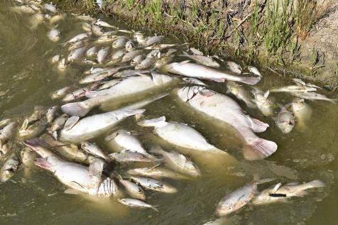
Investigations Into Fish Kill At Menindee

January 7th, 2019: Media release ran in Issue 389
The NSW Department of Primary Industries (DPI) and WaterNSW are investigating a large fish kill at Menindee in Western NSW.

In recent weeks fish kills have occurred in the Namoi River below Keepit Dam, the Lachlan River at Wyangala Dam and also in the the Darling River at Menindee in a separate event in December.

DPI Senior Fisheries Manager, Anthony Townsend, said fisheries officers have visited the affected area downstream of Menindee today and are investigating the incident.

“The ongoing drought conditions across western NSW have resulted in fish kills in a number of waterways recently and today our fisheries officers have confirmed a major fish kill event in the Darling River at Menindee affecting hundreds of thousands of fish, including Golden Perch, Murray Cod and Bony Herring,” Mr Townsend said.

“After a very hot period, a sharp cool change hit the Menindee region over the weekend, with large temperature drops experienced.

“This sudden drop in temperature may have disrupted an existing algal bloom at Menindee, killing the algae and resulting in the depletion of dissolved oxygen.”

The incident follows an earlier fish kill in December, after intense rainfall events following hot weather, which disrupted algal blooms resulting in low dissolved oxygen levels conditions that exacerbated water quality for already stressed fish.

During the December event investigations by District Fisheries Officers from DPI revealed over 10,000 fish mortalities along a 40km stretch of the Darling River, including numerous Murray Cod, Golden Perch and Silver Perch, and native Bony Herring.

Mr Townsend said preliminary investigations by DPI into the current fish kill event suggest that hundreds of thousands of native fish have been impacted in the same stretch of waterway and further downstream.

“As a result of this incident, DPI will take this opportunity to learn more about our native fish to help improve their future management,” Mr Townsend said.

“Our fisheries experts are extracting otoliths (or the ear bone) from some of the Murray Cod killed during the event to improve our knowledge of the species.

“Otoliths allow us to work out how old a fish is and can be used to help establish age and length/weight relationships, as well as potentially unearth other secrets including where the fish was born and spent its life through microchemistry work.

“All of this new knowledge will help improve how we manage waterways and the fishery across the entire Murray-Darling Basin to help protect and improve native fish populations when conditions improve.

“Fisheries staff would like to thank local anglers and residents who have provided information.

“The current low flows and warming temperatures are likely to pose an ongoing threat to native fish throughout the summer.”

WaterNSW is continuing to monitor water quality throughout the dams and river systems.

Adrian Langdon, WaterNSW executive manager of systems operations said regional NSW is experiencing intense drought conditions, with the state’s Central West, Far West and North West regions the worst affected.

“Algal alerts have been in place for several weeks in the Menindee region and linked to this, low dissolved oxygen levels are likely to occur within slow flowing or no flow sections of the river,” Mr Langdon said.

“It is almost certain these impacts will persist and possibly increase further as summer proceeds if we don’t receive significant rainfall to generate replenishment flows.”

Community members are encouraged not to be alarmed and to report any similar incidents or observations through the Fishers Watch hotline on 1800 043 536.
Locals say Murray Cod weighing up for 40kg have been killed.  Photo from Facebook: by Rod Mackenzie
___________________________________________________________________________________

Australia’s 2018 Environmental Scorecard: A Dreadful Year That Demands Action

April 4th 2019
by Albert Van Dijk
Professor, Water and Landscape Dynamics, Fenner School of Environment & Society, Australian National University

Environmental news is rarely good. But even by those low standards, 2018 was especially bad. That is the main conclusion from Australia’s Environment in 2018, the latest in an annual series of environmental condition reports, released today.

Every year, we analyse vast amounts of measurements from satellites and on-ground stations using algorithms and prediction models on a supercomputer. These volumes of data are turned into regional summary accounts that can be explored on our Australian Environment Explorer website. We interpret these data, along with other information from national and international reports, to assess how our environment is tracking.

A bad year
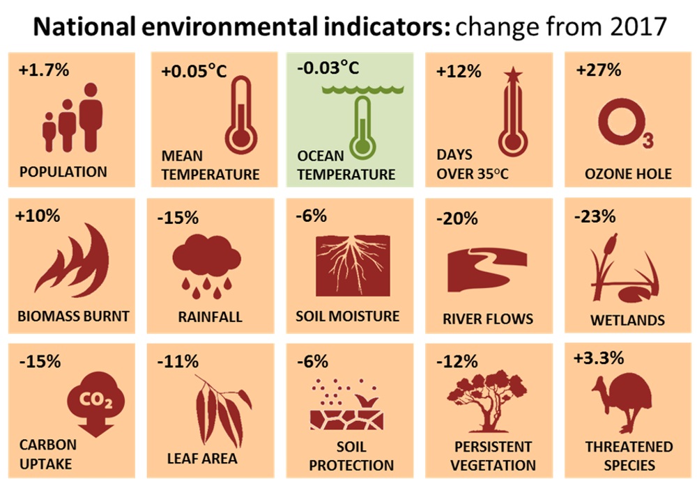
Whereas 2017 was already quite bad, 2018 saw many indicators dip even further into the red.
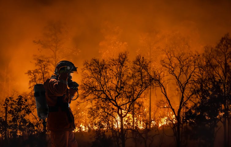
Temperatures went up again, rainfall declined further, and the destruction of vegetation and ecosystems by drought, fire and land clearing continued. Soil moisture, rivers and wetlands all declined, and vegetation growth was poor.

In short, our environment took a beating in 2018, and that was even before the oppressive heatwaves, bushfires and Darling River fish kills of January 2019.


Indicators of Australia’s environment in 2018 compared with the previous year. Similar to national economic indicators, they provide a summary but also hide regional variations, complex interactions and long-term context. source: http://www.ausenv.online/2018

The combined pressures from habitat destruction, climate change, and invasive pests and diseases are taking their toll on our unique plants and animals. Another 54 species were added to the official list of threatened species, which now stands at 1,775. That is 47% more than 18 years ago and puts Australia among the world’s worst performers in biodiversity protection. On the upside, the number of predator-proof islands or fenced-off reserves in Australia reached 188 in 2018, covering close to 2,500 square kilometres. They offer good prospects of saving at least 13 mammal species from extinction.

Globally, the increase of greenhouse gases in the atmosphere accelerated again after slowing down in 2017. Global air and ocean temperatures remained high, sea levels increased further, and even the ozone hole grew again, after shrinking during the previous two years.

Sea surface temperatures around Australia did not increase in 2018, but they nevertheless were well above long-term averages. Surveys of the Great Barrier Reef showed further declining health across the entire reef. An exceptional heatwave in late 2018 in Far North Queensland raised fears for yet another bout of coral bleaching, but this was averted when sudden massive downpours cooled surface waters.

The hot conditions did cause much damage to wildlife and vegetation, however, with spectacled flying foxes dropping dead from trees and fire ravaging what was once a tropical rainforest.

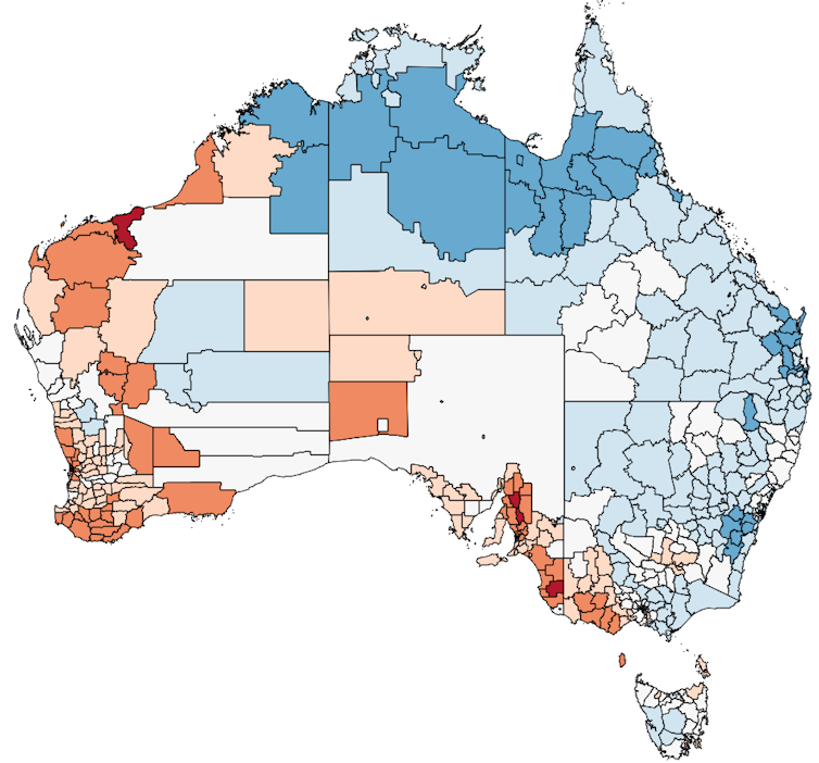
While previous environmental scorecards showed a mixed bag of regional impacts, 2018 was a poor year in all states and territories. Particularly badly hit was New South Wales, where after a second year of very poor rainfall, ecosystems and communities reached crisis point. Least affected was southern Western Australia, which enjoyed relatively cool and wet conditions.


Environmental Condition Score in 2018 by state and territory, based on a combination of seven indicators. The large number is the score for 2017, the smaller number the change from the previous year. source: http://www.ausenv.online/2018

It was a poor year for nature and farmers alike, with growing conditions in grazing, irrigated agriculture and dryland cropping each declining by 17-20% at a national scale. The only upside was improved cropping conditions in WA, which mitigated the 34% decline elsewhere.

A bad start to 2019
Although it is too early for a full picture, the first months of 2019 continued as badly as 2018 ended. The 2018-19 summer broke heat records across the country by large margins, bushfires raged through Tasmania’s forests, and a sudden turn in the hot weather killed scores of fish in the Darling River. The monsoon in northern Australia did not come until late January, the latest in decades, but then dumped a huge amount of rain on northern Queensland, flooding vast swathes of land.


It would be comforting to believe that our environment merely waxes and wanes with rainfall, and is resilient to yearly variations. To some extent, this is true. The current year may still turn wet and improve conditions, although a developing El Niño makes this less likely.

However, while we are good at acknowledging rapid changes, we are terrible at recognising slow, long-term ones. Underlying the yearly variations in weather is an unmistakable pattern of environmental decline that threatens our future.

What can we do about it?
Global warming is already with us, and strong action is required to avoid an even more dire future of rolling heatwaves and year-round bushfires. But while global climate change requires global action, there is a lot we can and have to do ourselves.


Australia is one of the world’s most wasteful societies, and there are many opportunities to clean up our act. Achieving progress is not hard, and despite shrill protests from vested interests and the ideologically blind, taking action will not take away our prosperity. Home solar systems and more efficient transport can in fact save money. Our country has huge opportunities for renewable energy, which can potentially create thousands of jobs. Together, we can indeed reduce emissions “in a canter” – all it takes is some clear national leadership.

The ongoing destruction of natural vegetation is as damaging as it is unnecessary, and stopping it will bring a raft of benefits. Our rivers and wetlands are more than just a source of cheap irrigation for big businesses. With more effort, we can save many species from extinction. Our farmers play a vital role in caring for our country, and we need to support them better in doing so.


Our environment is our life support. It provides us our place to live, our food, health, livelihoods, culture and identity. To protect it is to protect ourselves.

This article was coauthored by Shoshana Rapley, an ANU honours student and research assistant in the Fenner School of Environment and Society.

This article was published in The Conversation first, visit this Link to read the original. Republished under Creative Commons licence.
__________________________________________________________________________

NSW Government Opens The Floodgates For Irrigators To Profit From The Barwon-Darling River System

February 12, 2020 - Ran in Issue 438

Conservation groups are outraged at the NSW Government’s decision to allow big irrigators to take millions of litres of flood water from the Barwon-Darling river system. The government on Monday (February 10) temporarily overturned a restriction it placed on the capture of floodwaters just three days before on Friday (February 7).

The move could divert millions of litres of water from towns and the environment into the storages of large irrigators in the north of the basin.

“After such a prolonged drought, the priority for these vital first flows through the Barwon-Darling system must be to replenish town water supplies and revive fish stock and river ecosystems,” Nature Conservation Council CEO Chris Gambian said.

“Over-extraction by big irrigators, aided and abetted by the NSW Government, has made the impact of this drought much worse than it should have been. The drought is not yet over, and the government is at it again.

“The NSW Government’s management of the recent flows has been chaotic and poorly communicated, with three contradictory directions issued over the past week.

“On Friday, it simultaneously imposed a restriction on floodplain harvesting in the northern basin while also authorising landholders use of illegal levies and dams to capture and store overland flows. Then on Monday it announced a three-day free-for-all allowing irrigators to take as much water from the floodplain as they can pump.

“Once again the government appears to be pandering to the interests of big irrigators ahead of communities and the environment.”

Inland Rivers Network spokesperson Bev Smiles said: “These flows are the first ray of hope for the Darling River for years and should be allowed to flow through the system to Menindee Lakes and the Lower Darling.

“They are an important opportunity to reverse the extreme stress suffered by the Darling River and its dependent communities and wildlife.

“Now the government has authorised irrigators to harvest the best part of the flows in Namoi, Gwydir and Barwon rivers. The ad hoc approach to water management in western NSW has caused significant trauma to people, native fish and the riverine environment along the Darling River.

“This opportunity to revive the river system has been squandered at the behest of the powerful upstream irrigation lobby.”

____________________________________________________________________________

New Floodplain Harvesting Regulations Are A ‘Death Warrant’ For The Darling River

April 29, 2021 - Ran in Issue 493
New floodplain harvesting regulations gazetted today by the NSW Government will mean the end of the Darling-Baaka river and must be disallowed by the NSW Upper House next week, says Cate Faehrmann, Greens MP and water spokesperson.

“These regulations legalise the historic take of millions of litres of water that should have been sent downstream for communities and the environment and now will never get there,” said Cate Faehrmann.

“The Water Minister has just wilfully signed the Darling-Baaka river’s death warrant, it will be the final nail in the coffin for the Darling-Baaka river if it is not disallowed. 

“Despite the ICAC finding that many government decisions over the past decade have been inconsistent with the Water Management Act and the priorities of water sharing plans, the Water Minister continues to act in the interests of her big irrigator mates.

“The massive volumes of water these regulations will permanently give to a handful of big irrigators in the northern basin while the Darling-Baaka faces ecological collapse is an absolute disgrace. 

“The regulations also allow irrigators to take an unlimited amount of rainfall runoff which will be devastating for the Darling-Baaka river which relies on these flows.

“After a record flood event, dams in the north are near overflowing, while the Menindee lakes remain less than one third full. These new laws will legitimise and make permanent this massive over extraction,” said Ms Faehrmann.

The Nature Conservation Council is urging members of parliament to disallow new regulations legalising the practice of floodplain harvesting that were released, saying that allowing irrigators to divert floodwaters under the regulations will starve rivers, wetlands, and downstream communities and ecologies of huge volumes of water. 

“Many of our rivers and wetlands are already in a perilous state and this new regulation that will deprive them on a huge volume of precious water will have drastic consequences,” said Chris Gambian, Chief Executive of the Nature Conservation Council of NSW. 

“The environment movement urges all parliamentarians to vote to disallow this dreadful regulation and protect our rivers, wetlands and downstream communities. 

“Floodplain harvesting diverts a huge volume of water away from our rivers into private dams, and handing out new licences without proper safeguards, sustainable limits and guaranteed downstream targets will be repeating the mistake of overallocation of water that has already damaged the Murray-Darling Basin.  

“Many of our wetlands, floodplain environments, and lakes, and all the animals and plants they support, rely on regular flood events.  To allow irrigators to take up to 500% of a licence allocation in a single year is a recipe for disaster and will see important floodwaters stolen from the environment and downstream communities.  

“We’ve seen how hard and expensive it is to undo the mistakes of over allocating water resources in the past. 
  
"The regulations introduced by the government do not have the safeguards, limits and downstream targets to ensure that any diversion of floodwaters is sustainable. It is a death sentence for our rivers and wetlands.” 

Five Projects Set To Accelerate Murray Darling Basin Plan

May 6, 2021 -Ran in Issue 493
Implementation of the Murray Darling Basin Plan has shifted up a gear, following agreement between the Commonwealth and Basin states. Minister for Water, Property and Housing Melinda Pavey has announced details of the five accelerated key Sustainable Diversion Limit (SDL) projects agreed to at last week’s Murray Darling Ministerial Council meeting.

The projects being proposed for acceleration include the:
  • Sustainable Diversion Limit offsets in the Lower Murray: Locks 8 & 9 Project
  • Yanco Creek Modernisation Project (Modernising Supply Systems for Effluent Creeks Project)
  • Murrumbidgee & Murray National Park Project
  • Koondrook-Perricoota Flow Enabling Works (part of the Constraints Measures Program)
  • Mid-Murray Anabranches Constraints Demonstration Reach (part of the Constraints Measures Program)
Minister for Water, Property and Housing Melinda Pavey said the five projects will help NSW get on with the job of delivering the economic, social, environmental and cultural outcomes sought by the Basin Plan.

“These five projects, together with those projects already complete or on track for completion, will deliver approximately 75 per cent of the 605 GL water recovery target by 30 June 2024,” Mrs Pavey said.

“It is estimated these projects alone will deliver up to 45GL in NSW previously identified as being unrecoverable by the 2024 timeframe.

“The Locks 8 and 9 Project includes the installation of waterway structures allowing for flow regulation and fish passage within the Capitts and Bunberoo Creek system which will increase fish growth and promote bird breeding.

“The Yanco Creek Modernisation Project will keep the Yanco, Billabong, Colombo and Forest Creeks flowing and improve fish passage and habitats.

“These proposed projects will also help boost jobs in regional areas by creating an estimated 450 direct and 850 indirect regional jobs.

In addition to agreement being reached last week to accelerate a suite of projects to enable delivery by 2024, Ministers have recognised the unique sensitives around Menindee and Yanco and have agreed that NSW will spend the next two months re-working these projects.

"We have heard loud and clear from locals that they have felt they have been sidelined in previous attempts to get these projects off the ground.

“I have made it clear to both our NSW agencies and the Commonwealth that if these projects are to become a reality, communities will need to drive these projects with local knowledge the key to success.

“Community is at the heart of the success of these projects and locals have repeatedly said they have projects which can deliver good environmental, social and economic outcomes. Now is the time to make those ideas a reality.”

For details on the SDLAM Acceleration Program including full details of the five accelerated projects, please visit NSW Sustainable Diversion Limit Adjustment Mechanism projects.

________________________________________________________

NSW Government Shows Contempt For Democratic Process With 5th Introduction Of Floodplain Harvesting Regulations  


Friday February 3, 2023 - ran in Issue 570
The NSW Water Minister’s introduction of floodplain harvesting regulations for a fifth time shortly before an election shows complete and utter contempt for the voters of NSW, says Cate Faehrmann, Greens MP and water spokesperson. 


The NSW Government gazetted regulations to license floodplain harvesting on Friday afternoon after previous regulations were voted down for the 4th time by the NSW Legislative Council in September 2022. The NSW Parliament will not have an opportunity to consider the regulations until after the NSW state election on 25 March.


“This just shows complete contempt for the voters of NSW and for the traditional owners, downstream communities and farmers who have raised the alarm about these regulations for the entire last term of parliament,” says Ms Faehrmann. 

“The National Party has effectively hamstrung the will of the parliament by introducing these regulations now knowing that we will have no opportunity to vote on them until well after the election. 

“After each disallowance, I've called on the Water Minister to sit down and negotiate with the community instead of trying to shove the same laws down their throats again, but each time he’s done exactly that.  

“These regulations are just about ensuring the National Party’s big irrigator mates in the north get handed $1 billion in water rights for free. 

“We all want to see floodplain harvesting licensed, metered and measured, but it needs to be ecologically sustainable and within existing legal limits,” says Cate Faehrmann 

The Water Management (General) Amendment (Floodplain Harvesting Access Licences) Regulation 2023 is a death warrant for inland rivers according to the NSW Nature Conservation Council.

Thousands of kilometres of levee banks, or water barricades, choke the floodplains of NSW Murray-Darling Basin, diverting environmentally critical flood waters and rainfall runoff into private dams.

Nature Conservation Council (NCC) Chief Executive Officer Jacqui Mumford says these levees starve rivers and wetlands of the critically important medium sized floods that keep the system going in between the big flood years.

“It’s clear that the Perrottet Government is under the spell of big corporate irrigators. Why else would it ignore the fact that this disastrous regulation has been disallowed in the Upper House more than any other piece of legislation?

“Licencing such huge volumes of floodplain harvesting water, and legislating obscenely generous rules is locking in the rapid downward spiral of the iconic Darling-Baaka River and our internationally recognised wetlands. These rules allow accounts to accrue to 500% of the licence volumes. The approach is completely unsustainable.” Ms Mumford said.

NCC supports the licencing and regulation of floodplain harvesting, however the volumes and rules proposed by the current Liberal/National Coalition are not aligned with the laws of the state.

Ms Mumford said “The Government’s own Environment and Heritage Department has said that the proposed in-catchment targets are probably too low to protect key environmental assets in extreme dry periods, and do not support the water management principles of the Water Management Act 2000.

“The environmental, cultural, social and economic future of inland NSW depends completely on the health of our rivers and wetlands. Licencing flood waters at these volumes won’t allow river ecosystems to survive. They also ignore a very clear message provided to the Perrottet Coalition Government a record four times already; the community expects more than a death sentence for the rivers.

“The Coalition is ignoring the repeated decisions of the Upper House, disregarding the democratic process. The Perrottet Government has just doomed the inland rivers. It’s extremely disappointing.”

The Commonwealth Environmental Water Office Monitoring, Evaluation and Research program’s 2022 survey found not one single Murray Cod between Bourke and Louth.

Before the development of inland rivers with thousands of weirs, huge public dams and industrial scale corporate irrigation, the Darling-Baaka River teemed with an amazing array of aquatic life. The territorial Murray Cod could grow to 1.8 metres in length and weigh over 10 kilograms.

Ms Mumford says the fate of the Murray Cod is an alarming taste of what’s to come for the Basin unless more water is bought back to stay in rivers.

“The NSW Government can try all it likes to convince us that the Darling-Baaka used to regularly dry up like it did in 2019, but the disappearance of an entire species doesn’t lie. The collapse of the Darling-Baaka is happening before our eyes as a result of the politics of greed.”

The NSW Minister for Lands and Water, Nationals MP Kevin Anderson, has made no statement regarding the gazettal.

Currently the Legislative Assembly and Legislative Council have adjourned until Tuesday 28 February 2023. However, this is a nominal date only, as the Parliament is not expected to sit again prior to the State Election in March 2023. 

Following the election, the first meeting date of the new Parliament will be announced by the Governor and is likely to be in early May 2023.

__________________________________________________________________________

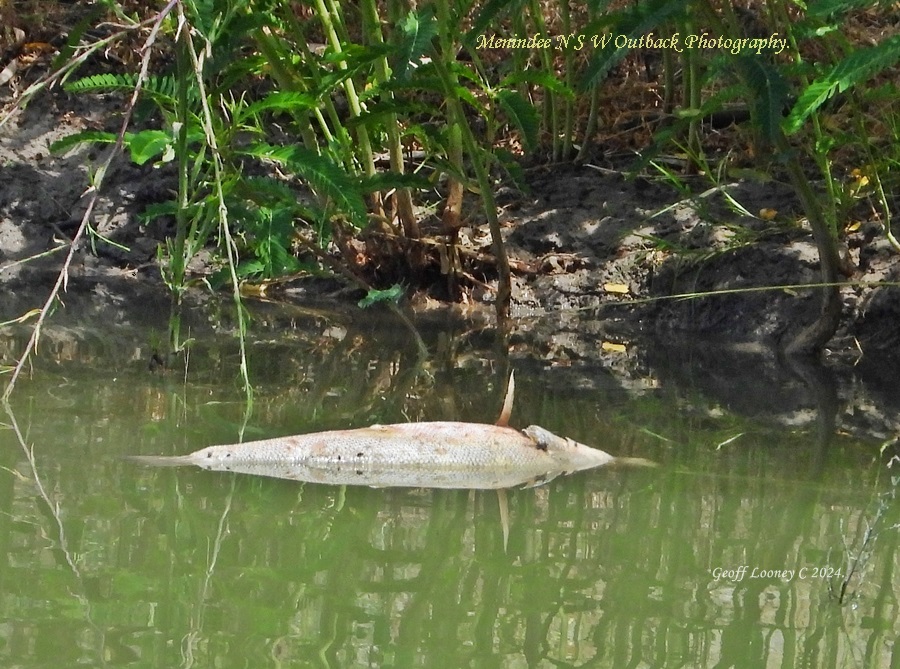
Further Fish Deaths At Menindee

February 12, 2024 - ran in Issue 614
NSW Fisheries is investigating reports of fish deaths in the Menindee Weir pool in the Darling River. Around 30 golden perch were found dead by locals on the weekend of February 10 to 11.

The NSW Government says it’s been advised oxygen levels are at a good level, and a lack of oxygen is not believed to be a contributing factor.
There have been several mass fish deaths in the river over the last few years.

Water NSW says flows from Lake Menindee will remain at fifty megalitres a day.


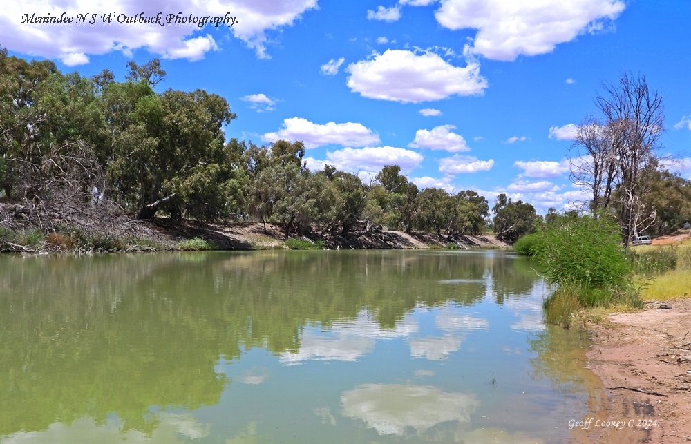
Photos: Menindee NSW Outback Photography by Geoff Looney
Geoff says:
''It's sad to see dead fish (Golden Perch) in the Darling again at Menindee. From what I observed today at Crick Park there were several dead  Golden Perch and they look like they have been dead for a while.  

The river itself does not look to bad so I don't know why they have died.  There was not a lot of activity on the surface like when they were short of oxygen in the past. ''
Photos taken 12.2.2024.

Golden perch or ‘yellowbelly’ are one of the main large-bodied native fish that are of high cultural importance for many First Nations.

In 2016, natural floods in Queensland and northern NSW, along with water for the environment triggered a large spawning of golden perch. The fish larvae drifted down the Darling River and ended up in the Menindee Lakes. Some larvae kept traveling down into the Lower Darling.

Menindee Lakes are a known nursery for yellowbelly, where baby fish get fattened up in the highly productive water. These lake fish are bigger and fatter than their river counterparts.

Golden perch that spawn in the Darling are really important to the whole of the southern Basin. Science—measuring fish ear bones—has shown that golden perch which spawn in the Darling often make up a large percentage of the total golden perch population in the River Murray. In fact, golden perch from the Darling also migrate upstream to the Edward-Wakool (NSW) and Goulburn Rivers (Vic).

The story is not so good further downstream. Over the past nine years, CEWO’s monitoring program has found very little evidence of golden perch recruitment—fish spawning that results in new individuals in the population—in the South Australian Lower Murray. This highlights the importance of using environmental water to support golden perch spawning events in the Darling River.

New Recreational Fishing Trust Advisory Council to oversee expenditure on recreational fishing funds

February 24, 2025

The Minns Labor Government states it has delivered on its election commitment to improve oversight of how NSW fishing licence fees are spent, with new regulation now in place to establish a Recreational Fishing Trusts Advisory Council to oversee the spending of the funds.

The new Recreational Fishing Trusts Advisory Council will be responsible for providing advice to the NSW Minister for Agriculture on all expenditure from the Recreational Fishing Freshwater and Saltwater Trusts.

Revenue raised from recreational fishing license fees, around $16 million annually, is placed into the Recreational Fishing Trusts and spent on improving recreational fishing experiences, opportunities and habitats in NSW.

Since 2001, the Recreational Fishing Trusts have supported funding for more than 3,300 large and small projects, with almost 3,000 projects completed.

By providing advice directly to the Minister, the Recreational Fishing Trusts Advisory Council will increase the confidence of recreational fishers in the way trust funds are spent, by improving the decision-making transparency.

In addition to members with expertise in recreational fishing, the new Recreational Fishing Trusts Advisory Council will look to have members with expertise in other important areas, including fisheries science and infrastructure construction, to assist with the review of the many diverse types of funding applications that are received each year.

The existing advisory council on recreational fishing will continue to provide a key role with its focus on advising the Minister on recreational fishing issues, while the new council will focus on how expenditure is allocated to projects and ensuring they benefit recreational fishers.

Appointment to the Recreational Fishing Trusts Advisory Council will be made following an open and transparent recruitment process that can now get underway following the change to the regulation.

Minister for Agriculture and Regional NSW, Tara Moriarty said:

“In 2023-24, over 400,000 NSW recreational fishing licences were issued, and the NSW Government is committed to ensuring that recreational fishers fishing fees are used transparently and deliver the greatest benefit to saltwater and freshwater fishers.

“Projects funded through the Recreational Fishing Trusts—ranging from improvements to fishing access and facilities, to the annual stocking of millions of fish into waterways—play a crucial role in enhancing fishing opportunities for both current and future fishers in NSW.

“The new Recreational Fishing Trusts Advisory Council will bring specific expertise to decision making processes and ensure that recreational fishers can have confidence in the way funds from the Recreational Fishing Trusts are used and invested.

“I look forward to welcoming applications and appointing members to the Recreational Fishing Trusts Advisory Council following an open and transparent recruitment process this year.”

Threatened native Trout Cod recovery underway with innovative fish breeding & stocking

February 26, 2025

The NSW Government has announced the 10-year Trout Cod Action Plan to recover the threatened native Trout Cod fish and delivering on its election commitment to boost the recovery of the fish and ensure its availability for recreational fishers.

The Government stated it is working to deliver better environmental outcomes for regional NSW and to deliver on its election commitments for recreational fishers who consider the Trout Cod a popular fish for angling.

''This commitment is demonstrated by the recent Government announcements delivering a review on the recreational fishing trust funds and establishing a $2 million fund for small infrastructure for recreational fishing.'' the government said

While there are a few small self-sustaining Trout Cod populations left in the wild in NSW the population has been in significant decline.

To bring about the recovery of the threatened Trout Cod populations more than $1 million of allocated funding is already being utilised with early actions of breeding and stocking underway while the broader action plan was being finalised.

The final Trout Cod Action Plan was developed after public consultation took place online and community information sessions in Wagga Wagga, Barooga, Bathurst and Queanbeyan.

Integral to the NSW Government’s commitment to the recovery of the Trout Cod, is increasing the production of fingerlings at Narrandera Fisheries Centre.

Early work to boost populations has seen a significant number of Trout Cod fingerlings bred at Narrandera in 2024 with 47,000 fingerlings released into waterways in the Snowy region, covering the Goodradigbee River and Talbingo Dam.

The Government is well on the way to achieving the Trout Cod Action Plan production target of 100,000 Trout Cod fingerlings per year and is confident of reaching 250,000 in the next 5-10 years.''

Trout Cod can be a difficult fish to breed and Narrandera has been trialling innovative ways to achieve better success including using pond spawning techniques rather than hormone induction. Pond based spawning is is potentially more productive and much gentler and kinder on the fish.''

The Government’s achievements under the Trout Cod Action Plan over the last 12 months include:

  • Moving to 100% pond-based spawning approach
  • Doubled the number of broodfish ponds at Narrandera Fisheries Centre
  • Developed a stocking and re-introduction strategy
  • Increased engagement with recreational fishers
  • Developing broodstock management strategy

Goodradigbee River has been a focus for conservation stocking efforts as it’s within the historical range of Trout Cod, has pristine and intact habitat including rocks, fast-flowing water, and is an unregulated part of the system with natural inflows to support recovery.

For more information about NSW DPIRD’s threatened species projects, visit: https://www.dpi.nsw.gov.au/fishing/threatened-species

NSW Minister for Agriculture and Regional NSW, Tara Moriarty said:

“The Minns Government is rapidly progressing its commitment to ensure the recovery of the native Trout Cod in our regional waterways with significant work underway to breed fingerlings while we engaged with the community on feedback for finalising the Action Plan.

“I’m pleased to say many of the participants of the community information sessions are very excited by the prospect of improved Trout Cod recovery.

“The Trout Cod Action Plan provides a 10-year blueprint to guide recovery actions, and while there is a long road ahead, I am confident there is a light at the end of the tunnel for this threatened species.

“There was a lot of interest from recreational anglers who are supporting the recovery of Trout Cod and I am pleased to say that those hoping to go fishing for Trout Cod can do so at Talbingo Dam where a catch and release fishery has been developed.

“We are hopeful that the Trout Cod Action Plan will fast track the recovery of Trout Cod populations in NSW back to appoint that they can once again become a genuine target for recreational fishers beyond the current Talbingo fishery.”

“With close to 50,000 fingerlings bred at Narrandera Fisheries Centre in 2024, triple the number produced in 2023, we are well on the way to achieving the goal of 250,000 bred annually.”

ACCC authorises major supermarkets to continue cooperation on soft plastics recycling

February 27, 2025

The ACCC has granted authorisation with conditions to the major supermarkets Coles Group, Woolworths Group and ALDI Stores, to continue their collaboration to recycle stockpiled soft plastics and implement the pilot in-store collection program until 31 July 2026.

The ACCC first authorised this collaboration granting interim authorisation in November 2022, following the collapse of REDcycle, which operated a nationwide soft plastics collection and recycling program.

“Our decision today allows the supermarkets to continue working together to process the remaining REDcycle legacy stockpiles,” ACCC Deputy Chair Mick Keogh said.

“Whilst it is encouraging to see that some progress is now being made as processing capacity improves, the ACCC expects that the supermarkets will continue to prioritise stockpile remediation efforts to prevent further delays.”

The ACCC has decided to impose the same reporting conditions as the previous authorisation, requiring the major supermarkets to provide the ACCC with quarterly progress reports and minutes of each meeting of the Soft Plastics Taskforce. These reports and minutes will be published on the ACCC’s public register.

It is also a condition that all arrangements must immediately stop when the authorisation expires or is revoked.

“This is a significant issue for many consumers, so continued transparency about what progress the supermarkets are making in their processing of the soft plastic stockpiles is important,” Mr Keogh said.

Authorisation will also allow the soft plastics instore collection pilot program to continue operating in Victoria and New South Wales and expand to other areas.

“It has been encouraging to see the pilot program expand under the current interim authorisation,” Mr Keogh said.

“Whilst we recognise that further expansion needs to be in line with available processing capacity, the ACCC expects that the supermarkets will continue with some urgency to expand these operations so that more consumers have the option of recycling their soft plastics.”

The ACCC’s authorisation is also subject to a new condition to prevent the major supermarkets from restricting recycling or logistic providers from supplying services to another customer.

Following the ACCC’s draft determination proposing to grant authorisation in December 2024, the ACCC received a small number of submissions, some of which were supportive while others called for broader involvement of the supermarkets in developing industry solutions to soft plastics.

The ACCC understands that any long-term soft plastics solution, whether in the form of an industry-led stewardship scheme or otherwise, is likely to be the subject of a separate, future application for authorisation and considers that the proposed conditions by interested parties are outside the scope of this authorisation.

Today’s authorisation does not include authorisation for any conduct of the supermarkets and their program partners with respect to any proposed stewardship scheme.

More information about the application including a copy of the decision is available here on the ACCC’s website.

ACCC authorisation provides statutory protection from court action for conduct that might otherwise raise concerns under the competition provisions of the Competition and Consumer Act (CCA).

Section 91 of the CCA allows the ACCC to grant interim authorisation when it considers it is appropriate and in the public benefit. This allows the parties to engage in proposed conduct while the ACCC is considering the merits of the substantive CCA authorisation application.

Broadly, the ACCC may grant an authorisation when it is satisfied that the public benefit from the conduct outweighs any public detriment.

Background

REDcycle was an industry-led return-to-store soft plastics collection and recycling program developed and operated by RG Programs and Services Pty Ltd. The major supermarkets partnered with REDcycle to provide collection points for consumers to return their soft plastics instore for collection by REDcycle for processing into durable recycled plastic products.

On 8 November 2022, REDcycle announced the indefinite suspension of its soft plastics collection program as its recycling partners had temporarily stopped accepting and processing soft plastics. Following REDcycle’s announcement, Coles and Woolworths each announced the suspension of soft plastic collections from their stores until further notice.

The supermarkets sought authorisation from the ACCC in November 2022 to enable them to collaborate to consider and develop solutions for the recycling of soft plastics. The ACCC’s interim authorisation on 25 November 2022 led to the establishment of the Soft Plastics Taskforce, chaired by the Department of Climate Change, Energy, the Environment and Water.

On 26 February 2023, the supermarkets assumed responsibility for the REDcycle stockpiles. It was later reported that approximately 11,000 tonnes of soft plastics had been stockpiled in over 44 locations. REDcycle’s parent company was declared insolvent on 27 February 2023 with a liquidator appointed.

The ACCC granted authorisation on 30 June 2023 for a period of 12 months to allow the supermarkets to collaborate with the Soft Plastics Task force to process the soft plastic stockpiles.

On 18 July 2024, the ACCC granted interim authorisation for substantially the same conduct authorised on 30 June 2023 while the ACCC considered the merits of the substantive application.

As part of the authorisation the supermarkets must submit a quarterly progress report to the ACCC.

The 22 January 2025 Progress Report provided by the supermarkets details the level of stockpiles remaining in each state and territory:

  • Victoria current stockpiles are approximately 2,200 tonnes
  • NSW current stockpiles are approximately 1,700 tonnes
  • South Australia current stockpiles are approximately 3,500 tonnes

Processing of stockpiles in Queensland and Western Australia has been completed.

The supermarkets report that as at end of December 2024, 45 tonnes of soft plastics have been collected through the instore collection pilot program, which is now operating in 107 stores across New South Wales and Victoria.

NSW supports new long-duration storage projects to boost reliability of the energy system

February 27, 2025

The NSW Government has stated it is taking further action to build a reliable, affordable energy system by supporting 3 new long-duration storage projects. The latest tender round – the largest of its kind in Australia – has for the first time selected a pumped hydro project, as well as two large-scale batteries.

''Long-duration storage serves an important role in the electricity system, allowing renewable energy such as solar and wind to be stored and then released on demand when needed.

This helps smooth the supply of renewable energy around the clock, reducing price spikes and placing downward pressure on electricity prices over time.'' the government said in a release

The projects, under the NSW Electricity Infrastructure Roadmap, include:

  • Two large-scale batteries, Stoney Creek Battery Energy Storage System (BESS) in Narrabri and Griffith BESS in Yoogali.
  • ACEN Phoenix Pumped Hydro Energy Storage, the first pumped hydro project to be successful in the Roadmap tender program, located near Lake Burrendong.

''The projects will create around 900 construction jobs and 60 ongoing positions. They will also help to secure at least $3.5 billion in investment in NSW’s energy system, bringing new investment to regional NSW and underscoring NSW’s place as a leading destination for energy industry investment.'' the government said

''Combined, the awarded projects represent 1.03 gigawatts or 13.79 gigawatt hours of energy storage capacity – exceeding the tender’s indicative target of 1 GW.

When fully charged, the one gigawatt of long duration storage will contain enough energy to power more than half a million households for a day, ensuring a reliable supply of electricity is available during periods when the sun isn’t shining, and the wind isn’t blowing.

The successful projects can each continuously dispatch electricity for at least 8 hours. The Lake Burrendong project offers a storage capacity equivalent to around 15 hours duration.

With the addition of these projects, NSW has now locked in 40% of its long-duration storage by 2030 target, and more than 65% of the recently legislated 2034 target.

The tender is the fifth conducted by AEMO Services as Consumer Trustee under the NSW Electricity Infrastructure Roadmap.

Other projects that will support the stability and reliability of the grid that are due to come online in NSW soon include the Waratah Super Battery, the Smithfield Battery Energy Storage System and Stage 1 of the Eraring Big Battery.''

Minister for Climate Change and Energy, Penny Sharpe stated:

'The Minns Labor government is delivering a reliable, affordable energy system that benefits communities and the economy.

'NSW is already powered by around 35% renewable energy. These projects will help ensure NSW households and businesses have access to affordable and reliable electricity as we continue to transform our grid.

'These new projects will drive local and regional economies with jobs and investment, while also delivering a reliable energy system for the whole of NSW.'

Emergency action to save native fish at risk of extinction

February 22, 2025

The Australian Government is investing $700,000 to save five species of galaxias fish which are at imminent risk of extinction

Urgent action is needed to protect these small native fish from the threat of introduced trout in the Gippsland region of Victoria.

Shaw, Tapered, West Gippsland, McDowell’s and Yalmy galaxias grow to less than 10 cm long, making them an ideal prey size for trout.

The project will identify at least three sites for each species where introduced trout are not present due to natural barriers like waterfalls.

Galaxiid fish bred by the Victorian Snobbs Creek Conservation Hatchery will be released at these sites in future. 

This will reduce their vulnerability to trout incursions and extreme events like droughts and bushfires, securing their survival in the wild and reducing the risk of extinction.

This funding is just one part of the Australian Government’s $224.5 million Saving Native Species program to better protect our precious native plants, animals and ecological communities.

Minister for the Environment and Water, Tanya Plibersek stated:

“We need to keep fighting to save all our threatened species, big and small. We know that invasive species like trout, cats and horses are one of the biggest threats to the survival of native species and without urgent action some of these fish will go extinct. 

"This is a great example of how our government is investing in projects that make a difference on the ground.”

Government funded Antarctic voyage to depart: Denman Glacier Research

The Federal Government’s icebreaking research vessel, the RSV Nuyina, will depart next week with 60 scientists on board heading to conduct globally important science in Antarctica’s Denman Glacier region.

In last year’s federal budget, the Albanese Government expanded the Antarctic science program.

This included an additional $17.6 million to enable the Nuyina to undertake more expeditions for scientific research, including its first dedicated marine science voyage to the Denman Glacier.

Research suggests the Denman Glacier retreated five kilometres between 1996 and 2017/2018 but compared to the glaciers of West Antarctica, it is little understood. 

The Australian Antarctic Program is coordinating an extensive study into the Denman Glacier’s history and stability, drawing together scientists from across universities and disciplines. 

The Denman Terrestrial Campaign runs from 2022 to 2025 and examines the glacier and the Shackleton Ice Shelf from the land.

The Denman Marine Voyage will be staged from RSV Nuyina  will allow scientists to study the system from the sea.

The Denman campaigns will inform national and global decision-making about climate change responses and deliver on priorities in the Australian Antarctic Science Strategic Plan.

If this glacier melts, sea levels could rise by 1.5 metres – making this research trip more important than ever.

The research will help understand factors affecting the melt rate of this critically important glacier. Scientists will also conduct projects like sea floor mapping, tagging seals with ocean monitoring devices, and sampling of trace animal DNA in the water to find out what lives in the area.

The voyage brings together scientists from the Australian Antarctic Division, Securing Antarctica’s Environmental Future, The Australian Antarctic Program Partnership and the Australian Centre for Excellence in Antarctic Science.

The voyage left Burnie on February 27 and returns to Hobart in early May.

Minister for Environment and water, Tanya Plibersek MP said:

“The Denman Glacier is globally significant, but sadly it’s under threat from climate change.

“We know the decline of this glacier doesn’t just impact Antarctic region – it could affect the Southern Ocean and even the world’s ecosystems.  

“That’s why the Albanese Labor Government is investing $17.6 million to enable the Nuyina to undertake more expeditions for scientific research - including the first dedicated marine science voyage to the Denman Glacier.  

“This is one of Australia’s most ambitious scientific endeavours in decades, sending an elite group of researchers to one of the world’s most remote places.

“They’ll be chasing answers to the big questions surrounding the future of the Denman Glacier.

“This is part of the Government’s $1.5 billion investment in Antarctic science. Antarctic and Southern Ocean science has never been more important, and I’m proud of Australia’s contribution as a leader in this field.

“We know funding Antarctic and Southern Ocean research is great for the economy too. The sector employs 1,000 Tasmanians and generates $183 million for the Tasmanian economy every year.”

Senator Carol Brown stated:

"Tasmania has a long and proud history as Australia's Antarctic gateway, and the Australian Antarctic Division and RSV Nuyina are a big part of that. They’re uniquely Tasmanian and strong employers of Tasmanians. I’m proud to back jobs right here in our state.

"The Albanese Government believes in making decisions based on science. That’s why we’re investing in critical Antarctic research—to better understand climate change and its impact on our planet.

"This voyage is another example of our government’s commitment to Antarctic research. We’re investing $188 million in Macquarie Wharf 6 to secure Tasmania’s role as Australia’s Antarctic gateway and ensure RSV Nuyina has the infrastructure it needs to support world-leading science."

Senator Catryna Bilyk said:

“Antarctic and Southern Ocean research makes a vital contribution to our understanding of the global impacts of climate change. When it comes to understanding the way climate change affects our world, Antarctica is the canary in the coal mine.

“As a Tasmanian, I am proud of Hobart’s role as the gateway to Antarctica. I am also proud of the important investments the Albanese Labor Government is making in securing Hobart’s place as the centre of Antarctic science and backing this world-leading research and the talented scientists who are undertaking it.”

Denman Glacier Photo: Greg Barras

Statement: Bureau of Meteorology CEO and Director of Meteorology

20 February 2025: The Hon Tanya Plibersek MP, Minister for the Environment and Water

The CEO of the Bureau of Meteorology and Director of Meteorology, Dr Andrew Johnson PSM, has advised me of his intention to conclude his term in early September 2025, after nine years at the helm.

During Dr Johnson's tenure, the Bureau has delivered new and upgraded fire, flood, bushfire, heatwave, cyclone, marine, climate and space weather services; expanded the fleet of weather radars, automatic weather stations and flood warning infrastructure; and made the Bureau’s technology capabilities secure, stable and resilient. The BoM Weather app is now used by over 15 million people. These are all significant achievements.

Australians should be proud that the Bureau is considered one of the world's most respected meteorological agencies. This is a credit to Dr Johnson and his hardworking team.

Under Dr Johnson’s leadership, when our nation has most needed the Bureau, it has delivered trusted and reliable services during successive fire, flood and cyclone emergencies, many of which occurred during COVID-19 pandemic. It has also continued to play a strong role in our region, especially helping build the capacity of Pacific Islands nations to prepare for and respond to the impacts of severe weather in a changing climate.

On behalf of the Federal Government, I sincerely thank Dr Johnson for his many years of dedicated service to the Bureau, and the Australian community. I wish him all the very best in his future endeavours.

A powerful force is stopping the Indian Ocean from cooling itself – spelling more danger for Ningaloo

Violeta Brosig/Blue Media Exmouth
Kelly Boden-HawesThe University of Western Australia and Nicole L. JonesThe University of Western Australia

Widespread coral bleaching at Ningaloo Reef off Western Australia’s coast has deeply alarmed scientists and conservationists.

Photos captured by divers, published by The Guardian last week, show severe bleaching at several sites along the reef, which runs for 260 kilometres off the state’s northwest.

A severe marine heatwave in the Indian Ocean off WA has caused the coral bleaching. In some places, surface temperatures up to 4°C warmer than usual have been recorded.

Hotter temperatures aren’t only happening at the ocean’s surface – data indicates they also extend several hundred metres deep. Warm, deeper water can shut down the ocean’s natural cooling process, putting corals at even greater risk of bleaching.

Counting the cost

The full extent of damage to Ningaloo won’t be known until scientists conduct field surveys in coming months.

So far, bleaching has been documented at several sites, including Turquoise Bay, Coral Bay, Tantabiddi, and Bundegi (Exmouth Gulf).

Other sites such as Scott Reef, Ashmore Reef, the Rowley Shoals and Rottnest Island are also at risk.

Damage wrought by the heatwave extends beyond coral. More than 30,000 fish have died since the September onset.

The below images show the heatwave’s progression. Temperatures from February last year are included for comparison.

The white circle shows the location of Ningaloo. Cooler temperatures are in blue and purple. Warmer temperatures are in yellow and orange.

The images show the heatwave reached Ningaloo in December last year and moved south in January. Temperatures fell slightly in February due to strong southerly winds. From March, temperatures are forecast to increase again.

A complex warming picture

According to recent data and modelled forecasts, hotter ocean temperatures off northern WA run several hundred metres deep.

This has been caused by developing La Nina conditionsLa Nina and its opposite, El Nino, influence ocean temperatures and weather patterns across the Pacific.

During La Nina, trade winds strengthen and push warm water westward. This intensifies two important ocean currents.

The first is the Indonesian Throughflow – which carries warm Pacific waters through the Indonesian seas and into the eastern Indian Ocean. The second is the Leeuwin Current, which picks up this warm water and takes it further south towards Perth.

This has led to a build-up of hotter water along the WA coastline.

La Nina is also affecting WA’s reefs in other ways.

Some coral reefs are naturally cooled by local tides which pull deep, colder water towards the surface. This process, which has been likened to an ocean’s “air conditioner”, can temporarily relieve heat stress for reefs.

The process relies on “stratification” – that is, layers of seawater that differ in temperature, salinity and density (or weight). Warmer, less dense water collects at the surface and colder, denser water falls to deeper levels.

La Nina conditions can suppress, or even shut down, this cooling effect in two ways.

First, it reduces the difference in density between ocean layers. This causes water to draw upwards from shallower depths. Second, it increases water temperatures at depth.

All this means the water pumped to the surface isn’t much cooler than temperatures at the surface.

For many reefs along the coast of WA, the suppression of this tidal cooling is probably contributing to worsening conditions, and more coral bleaching.

Most bleaching forecasts rely on sea surface temperatures. This means scientists may be underestimating the vulnerability of deeper reefs.

What’s in store for Ningaloo and surrounds?

Looking ahead, the situation at Ningaloo and surrounding reefs remains critical.

Bleached reefs are able to recover if temperatures cool quickly. This means theoretically, Ningaloo and other affected reefs may survive the summer.

But unfortunately, temperatures are rising again and the marine heatwave is expected to continue until April, as the below image shows.

Sea surface temperature anomaly forecast for March to May. Ningaloo denoted with black ‘X’. Bureau of Meteorology

Climate change is making marine heatwaves more intense and frequent. It means reefs often don’t have time to recover between destructive bleaching events.

All this is compounded by the general trend towards warmer oceans as the planet heats up.

Drastic action on climate change is needed now. If this alarming pattern continues, the world’s reefs risk being lost entirely.The Conversation

Kelly Boden-Hawes, PhD Candidate in oceanography, The University of Western Australia and Nicole L. Jones, Professor of Physical Oceanography, The University of Western Australia

This article is republished from The Conversation under a Creative Commons license. Read the original article.

The promise of green iron, steel and ammonia is keeping the green hydrogen dream alive

D.Alimkin, Shutterstock
Changlong WangMonash University and Stuart WalshMonash University

Hydrogen was once sold as a universal climate fix — a clean, green wonder fuel for cars, homes, power grids and even global export. But reality has cooled that buzz.

This week, the South Australian government shelved plans for a A$593 million hydrogen power plant, in favour of injecting that money into the $2.4 billion Whyalla steelworks rescue package. Premier Peter Malinauskas said there was “no point in producing hydrogen” without a customer: the steelworks.

It’s the latest in a series of setbacks for hydrogen. Last year, Australian mining and energy giant Fortescue pared back its green hydrogen projects as a result of increasing costs and changing financial circumstances in the United States.

Then, gas and oil heavyweight Woodside withdrew plans for two large-scale green hydrogen projects and Origin Energy dropped out of the Hunter Valley Hydrogen Hub.

Meanwhile, the Hydrogen Energy Supply Chain project in Victoria, meant to ship hydrogen to Japan, has met with delays and overruns. Earlier this month, the new Queensland government chose to halt further investment in the Central Queensland Hydrogen Project, putting plans to export hydrogen in doubt.

These setbacks show hydrogen isn’t the ultimate solution to all our energy needs, especially if we want to export it. But they don’t spell doom. Instead, they nudge us toward where hydrogen really shines: in heavy industry, right where it’s made.

Heavy industry: where hydrogen makes sense

Heavy industries such as steel manufacturing and ammonia production are where hydrogen proves its worth. These sectors are significant contributors to climate change — steel accounts for about 8% of global greenhouse gas emissions, ammonia a further 2%.

Most emissions from steelmaking come from burning coal in blast furnaces to convert ore into iron and carbon dioxide.

In a cleaner alternative, hydrogen (when produced using renewable energy) can be used to strip oxygen from the ore and make iron, with water as a byproduct. The result is green iron, ready to be turned into steel in an electric arc furnace – with a fraction of the emissions.

Ammonia is used to make fertiliser and industrial chemicals, and hydrogen is one of the main ingredients in its production. Hydrogen bonds with nitrogen from the air to form ammonia. No hydrogen, no ammonia — it’s that simple. Conventional ammonia plants get hydrogen from methane, producing CO₂ in the process. Green ammonia uses renewable energy to produce hydrogen by splitting water via electrolysis.

Our recent research crunched the numbers on producing these new green commodities. We found making green iron in Australia with hydrogen and shipping it to Europe for steel production could be 21% cheaper than exporting raw iron ore and hydrogen separately. Plus, it could cut emissions by up to 95% compared to traditional methods.

There are huge economic opportunities for Australia too. Instead of shipping low-value raw materials, Australia could export ready-to-use green iron or green steel, reshaping global supply chains while cutting costs and carbon. That’s the kind of rethink hydrogen enables.

Industry hubs: a practical fix

Transporting hydrogen long distances is costly and inefficient. The fix? Industry hubs that produce hydrogen right where it’s needed — next to steel mills, ammonia plants, desalination plants, water treatment plants or even aluminium smelters. Putting producers and consumers together slashes transport costs and unlocks efficiencies.

We’ve built tools to pinpoint places with the greatest potential to produce these new green commodities.

The Hydrogen Economic Fairways Tool maps where renewable energy, infrastructure and industrial sites align for cost-effective hydrogen production.

The Green Steel Economic Fairways Mapper zooms in on prime locations for green steel, spotlighting places such as Eyre Peninsula in SA and the Pilbara in Western Australia, among others (see below). These locations have abundant wind and solar resources alongside an existing industrial base.

Examples of maps and charts available using the Green Steel Economic Fairways mapping tool
The Green Steel Economic Fairways Mapper compares the levelised cost of steel, including production and transport to the port. a) Regional changes across Australia b) Example of how to optimise the system to minimise the levelised cost of producing 1 million tonnes per annum c) Breakdown of costs d) Hourly system performance, in terms of energy flows. Green Steel Economic Fairways Mapper, Geoscience Australia

Challenges remain

Green hydrogen promises to revolutionise heavy industries, but significant hurdles stand in the way of widespread domestic adoption. The biggest challenge comes from the unpredictable nature of renewable energy, which makes it hard to maintain the steady hydrogen supply industries need.

The costs remain steep, too. Splitting water into hydrogen using renewable electricity isn’t cheap, particularly when you need backup storage systems to keep production going during cloudy or windless periods.

Getting hydrogen where it needs to go poses another major challenge. As hydrogen is both bulky to transport and highly flammable, it requires special handling and infrastructure, driving up costs, especially for facilities far from production sites.

Many companies also hesitate to invest in hydrogen-compatible equipment, as retrofitting existing plants or building new ones requires substantial upfront costs without guaranteed returns.

The $2.4 billion rescue package for the Whyalla Steelworks (ABC News)

Government backing: a push in the right direction

Thursday’s announcement of A$2.4 billion investment in the Whyalla steelworks along with plans for a $1 billion green iron investment fund are a bold bet on green steel. Furthermore, the landmark Future Made in Australia legislation introduces a $6.7 billion Hydrogen Production Tax Incentive, offering $2 per kilogram of renewable hydrogen produced between 2027–28 and 2039–40, alongside a 10% tax credit for critical minerals processing.

Meanwhile tax credits for green aluminium and alumina should help another heavy industry to navigate the energy transition using clean hydrogen.

These measures aim to unlock tens of billions in private investment, boost regional economies, and position Australia as a leader in clean energy manufacturing. This isn’t just about one-off projects. It’s laying the groundwork for hubs that link renewable energy and hydrogen production to industrial demand.

There’s more in the pipeline. The Hydrogen Headstart program pumps funds into hydrogen innovation, and the Future Made in Australia initiative backs clean industry with billions more. Add in policies like carbon pricing or low-interest loans, and the economics tilt even further toward green steel and ammonia. Government buying power — in the form of procurement targets for low-carbon materials — could seal the deal by guaranteeing demand.

These policies aren’t just wishful thinking — they’re practical steps that are already working elsewhere. Sweden’s HYBRIT project, which paired green steel with government-backed demand, has already led to construction starting on new industrial-scale green steel facilities. At the same time, the European Union’s hydrogen strategy leans on carbon pricing and subsidies to guide industries and suppliers through the energy transition, while Japan offers incentives for the use of green steel in their automotive industry.

Australia has the renewable energy and the industrial base to take advantage of these opportunities. With the right leadership, we can turn hydrogen’s stumbles into a global triumph for heavy industry.The Conversation

Changlong Wang, Research fellow in Civil and Environmental Engineering, Monash University and Stuart Walsh, Senior lecturer in Civil and Environmental Engineering, Monash University

This article is republished from The Conversation under a Creative Commons license. Read the original article.

Farmers, investors, miners and parents: how unconventional climate advocates can reach new audiences

Max Acronym/Shutterstock
Xiongzhi WangAustralian National UniversityKelly FieldingThe University of QueenslandRebecca ColvinAustralian National UniversityRobyn GulliverThe University of Queensland, and Winnifred LouisThe University of Queensland

When you think about climate advocates, you’ll likely picture left-leaning environmentalists who live in cities. This group has contributed to building public support for climate action worldwide, through protests, petitions, lobbying and so on.

While a majority of Australians understand that climate change is happening and that humans are the main cause, there are still holdout groups. Acceptance of the fact that climate change is largely caused by humans sits at 60% of Australians, well below other countries.

Holdout groups in Australia can include people associated with political conservatism, the business sector, farming, the resource sector, some religious groups and some sports fans. For these groups, climate advocacy by left-leaning environmentalists may be limited in its effectiveness.

How do you reach these groups? Our new research points to one solution: unconventional climate advocates. That is, those not from the stereotypical background and who belong to holdout groups. Think of groups such as Farmers for Climate Action and the Investor Group on Climate Change.

These individuals and groups can play a crucial role in expanding the base of the climate movement – without necessarily working with mainstream climate groups. Better still, we found these unconventional advocates tend to receive more sympathetic media coverage.

Who are these unconventional advocates?

We distinguish two types of unconventional climate advocates –role-based and bridge-builders.

Role-based advocates come from groups not typically associated with climate advocacy, such as Australian Parents for Climate Action, Doctors for the Environment, Vets for Climate Action and Australian Firefighters Climate Alliance. These advocates broaden our perception of who engages in climate advocacy.

Bridge-builders come from groups with a history of tension with environmentalists and environmental issues. They can often span the divide between their group and the broader climate movement. These groups include Farmers for Climate Action, Investor Group on Climate Change, Hunter Jobs Alliance and Australian Religious Response to Climate Change.

Why do they matter?

Unconventional advocates are vital because they can reach a broader section of the population. This is because we are more likely to listen to insiders: people from groups we identify with who share our values and beliefs. We also pay more attention to messages when they come from a surprising source and when they go against perceived interests.

A farmer advocating for climate action is more likely to resonate with other farmers than city-based environmentalists, for instance. Similarly, if you expect farmers to be opposed to climate action, you’re more likely to pay attention to their message than if it came from an environmentalist.

Our research shows these groups are not mainstream environmentalists. They exist on the periphery of the climate movement.

Using social network analysis, we mapped the connections between more than 3,000 climate advocacy groups in Australia. This showed us unconventional advocates are less connected to traditional environmental groups such as Greenpeace Australia Pacific or the Australian Conservation Foundation.

This distance may actually be advantageous. By maintaining a degree of independence from the mainstream environmental movement, unconventional advocates can avoid being dismissed as “greenies” – an unpopular group for some people in rural areas. Farmers advocating for climate action may be more effective if they’re not seen as aligned with environmentalists who might be viewed with suspicion in rural communities.

Does unconventional advocacy work?

By one metric, unconventional advocacy does work. These individuals and groups broadly receive more sympathetic media coverage.

In recent research, we analysed more than 17,000 Australian media articles published between 2017 and 2022 mentioning unconventional and more stereotypical environmentalist climate advocacy groups.

We found Greenpeace Australia Pacific and other established groups received the most media coverage overall. Disruptive groups such as Extinction Rebellion tended to be framed negatively, with a focus on conflict and arrests. The negativity was most pronounced in articles published by News Corp, owned by the conservative media figure Rupert Murdoch.

Unconventional advocates received less media coverage than other types of advocates. When they did receive coverage, it was generally more sympathetic. Articles tended to focus on their achievements and to use less confrontational language, even from conservative-leaning media outlets.

This suggests unconventional advocates are well positioned to shift public opinion in holdout groups and build a broader base of support for climate action.

Unconventional advocates for unprecedented times

In Australia and in many other countries, climate action has become politicised – often along party lines. Holdout groups are a minority, but a large minority. To actually respond to the increasing threat of climate change will require building a bigger base of support.

Unconventional advocates offer a way to disrupt hardened divides, expand the range of voices in the movement and engage communities and groups often left out of the conversation.The Conversation

Xiongzhi Wang, Postdoctoral Research Fellow in Environmental Social Science, Australian National UniversityKelly Fielding, Professor of Environmental Psychology, The University of QueenslandRebecca Colvin, Associate Professor in Social Science, Australian National UniversityRobyn Gulliver, Honorary Research Fellow in Social Science, The University of Queensland, and Winnifred Louis, Professor of Social Psychology, The University of Queensland

This article is republished from The Conversation under a Creative Commons license. Read the original article.

Want a side of CO₂ with that? Better food labels help us choose more climate-friendly foods

udra11, Shutterstock
Yi LiMacquarie University

When you’re deciding what to eat for lunch or dinner, do you consider the meal’s greenhouse gas emissions? How do you compare the carbon footprint of a beef sandwich with that of a falafel wrap?

Most people can’t tell what’s better for the climate. Even those who care deeply about making sustainable food choices can struggle.

In Australia, meat products are responsible for almost half (49%) the greenhouse gas emissions of products consumed at home. Switching from these high-emission foods to lower-emission foods, such as plant-based meals, can significantly reduce household emissions. But a lack of knowledge may be stopping people doing the right thing.

The good news is my colleagues and I have a simple solution. Highlighting the source of the food as animal- or plant-based on carbon labels makes a big difference to consumer choices. In our latest research, we show this new carbon label encourages switching from animal-based to plant-based foods.

Closing the knowledge gap

Previous research has shown consumers consistently underestimate the vast difference in greenhouse gas emissions between animal- and plant-based foods. For instance, producing one kilogram of beef emits 60kg of greenhouse gases, whereas producing the same quantity of peas emits just 1kg of greenhouse gases. However, most people think the gap between the two is much smaller.

This matters because collectively, our food choices have a big impact on climate change. Agriculture generates almost a third of global greenhouse gas emissions, with animal products the biggest contributors.

Making carbon labels more informative

A “carbon footprint” refers to the greenhouse gas emissions associated with a product.

Globally, there is increasing interest in carbon food labelling, given its potential to nudge consumers towards more sustainable food choices. In Australia, such labelling is voluntary and not yet widespread.

Most carbon labels follow a similar approach. They typically display a number representing greenhouse gas emissions, and a traffic-light system indicating the level of environmental impact from green (low) to red (high). But such labels do not indicate whether the food is animal- or plant-based. So a high carbon score does not help people identify the source of the emissions.

Comparing four different types of food labels, from the most basic 'carbon neutral' to quantifying the carbon dioxide emissions, adding the colour coded traffic light and finally, indicating the source as mainly plant or animal. system
Our label maps the carbon footprint to the source of the food, whether plant or animal, along with information about the greenhouse gas emissions. Romain Cadario, Yi Li, Anne-Kathrin Klesse, (2025) Appetite.CC BY

We designed a new type of label. It clearly displays whether the food is sourced mainly from animals or plants, along with the standard emissions score and traffic-light colour code. This approach is especially useful for the growing segment of pre-prepared and packaged foods such as soups and other ready-to-eat meals, which often contain a mix of meat and plant-based food.

Our label creates a mental link between a food source and its carbon impact. When a consumer sees high carbon scores and red traffic lights appearing more frequently on meat and other animal products, they begin to make the connection between those products and higher emissions. This is key to addressing a lack of knowledge around food carbon emissions.

We tested our label against the existing labels in a series of experiments with 1,817 everyday consumers from Australia, the United States and the Netherlands.

One experiment involved soup. Compared with the group exposed to the standard carbon label, the group exposed to our label learned to associate animal-based soups with higher greenhouse gas emissions more effectively. They were more accurate at estimating the greenhouse gas emissions of a second batch of soups without labels.

This improved knowledge also translates to more climate-friendly food choices. In another experiment with Australian consumers, we encouraged participants to choose five meals from ten options. Five were animal-based and five were plant-based.

Half the participants saw the meal options with our carbon labels, and the other half did not see the carbon labels. The group exposed to our carbon labels chose fewer animal-based options in their weekly meal plan. In this case, we don’t know whether a third group exposed to the standard label would also make more climate-friendly choices, but our earlier experiments suggested our label was more effective.

In the final experiment conducted in the Netherlands, displaying our carbon label made university students more likely to choose the plant-based snack option rather than the animal-based option.

A selection of ten meals with images of the dish alongside the detailed carbon labels, including whether the food is mainly plant-based or animal-based.
Providing information about the source of the food, whether plant or animal, influenced choices of meal plans. Romain Cadario, Yi Li, Anne-Kathrin Klesse, (2025) Appetite.CC BY

When knowledge isn’t enough

While people who care most about sustainable eating may think they know better than others, we found that is not the case. These people were not better able than other participants to tell the difference in greenhouse gas emissions between animal- and plant-based foods without seeing our carbon label.

But they were better learners. When confronted with the facts about the differences between animal and plant-based foods on our labels, they were more likely to change their choices and switch to plant-based foods.

What this means for consumers and businesses

A simple change to food labels could help consumers make more informed environmental choices. For businesses and policymakers, it shows displaying only carbon numbers isn’t enough – the food source is crucial.

Some forward-thinking restaurants and food companies are already experimenting with adding carbon labels to the menu to encourage diners to choose climate-friendly dishes. Our research suggests this approach could be more effective when combined with the new carbon labels we designed.

A person holds up a handmade poster at a protest or rally that reads 'less meat, less heat'
Meat products make a significant contribution to climate change. Valmedia, Shutterstock

Implications for climate action

As Australia grapples with meeting its climate commitments, helping consumers understand the environmental impact of their food choices will become increasingly important.

The challenge for businesses, policymakers and researchers isn’t convincing people to care about sustainability – they already do. Almost half of Australian shoppers (46%) say sustainability is important to them and influences their purchases, despite cost-of-living pressures.

But most sustainable actions in retail involve recyclable packaging, products and materials, and local produce. The carbon emission implications of these actions, sadly, are far less than reducing animal-based food consumption.

Instead, we need to focus on giving people the tools to make their environmental concerns count. Our carbon labels could be the key to helping consumers turn their sustainable intentions into meaningful climate action.The Conversation

Yi Li, Senior Lecturer in Marketing, Macquarie University

This article is republished from The Conversation under a Creative Commons license. Read the original article.

Nose-to-tail mining: how making sand from ore could solve a looming crisis

Thanagornsoisep/Shutterstock
Daniel FranksThe University of Queensland

Every year, the world consumes around 50 billion tonnes of sand, gravel and crushed stone. The astonishing scale of this demand is hard to comprehend – 12.5 million Olympic sized swimming pools per year – making it the most-used solid material by humans.

Most of us don’t see the sand and gravel all around us. It’s hidden in concrete footpaths and buildings, the glass in our windows and in the microchips that drive our technology.

Demand is set to increase further – even as the extraction of sand and gravel from rivers, lakes, beaches and oceans is triggering an environmental crisis.

Sand does renew naturally, but in many regions, natural sand supplies are being depleted far faster than they can be replenished. Desert sand often has grains too round for use in construction and deserts are usually far from cities, while sand alternatives made by crushing rock are energy- and emissions-intensive.

But there’s a major opportunity here, as we outline in our new research. Every year, the mining industry crushes and discards billions of tonnes of the same minerals as waste during the process of mining metals. By volume, mining waste is the single largest source of waste we make.

There’s nothing magical about sand. It’s made up of particles of weathered rock. Gravel is larger particles. Our research has found companies mining metals can get more out of their ores, by processing the ore to produce sand as well.

This would solve two problems at once: how to avoid mining waste and how to tackle the sand crisis. We dub this “nose-to-tail” mining, following the trend in gastronomy to use every part of an animal.

man with concrete mixer.
Concrete is everywhere – but it requires a great deal of sand and gravel. MVolodymyr/Shutterstock

The failings of tailings

The metal sulphides, oxides and carbonates which can be turned into iron, copper and other metals are only a small fraction of the huge volumes of ore which have to be processed. Every year, the world produces about 13 billion tonnes of tailings – the ground-up rock left over after valuable metals are extracted – and another 72 billion tonnes of waste rock, which has been blasted but not ground up.

For decades, scientists have dreamed of using tailings as a substitute for natural sand. Tailings are often rich in silicates, the principal component of sand.

But to date, the reality has been disappointing. More than 18,000 research papers have been published on the topic in the last 25 years. But only a handful of mines have found ways to repurpose and sell tailings.

Why? First, tailings rarely meet the strict specifications required for construction materials, such as the size of the particles, the mineral composition and the durability.

Second, they come with a stigma. Tailings often contain hazardous substances liberated during mining. This makes governments and consumers understandably cautious about using mining waste in homes and our built environment.

Neither of these problems is insurmountable. In our research, we propose a new solution: manufacture sand directly from ore.

Converting rock into metal is a complex, multi-step process which differs by type of metal and by type of ore. After crushing, the minerals in the ore are typically separated using flotation, where the metal-containing sulphide minerals attach to tiny bubbles that float up through the slurry of rock and water.

At this stage, leftover ore is normally separated out to be disposed of as waste. But if we continue to process the ore, such as by spinning it in a cyclone, impurities can be removed and the right particle size and shape can be achieved to meet the specifications for sand.

We have dubbed this “ore-sand”, to distinguish it from tailings. It’s not made from waste tailings – it’s a deliberate product of the ore.

iron ore on conveyor belt
Turning ore into metal requires intensive crushing and grinding. These methods could also make sand. Aussie Family Living/Shutterstock

More from ore

This isn’t just theory. At the iron ore mine Brucutu in Brazil, the mining company Vale is already producing one million tonnes of ore-sand annually. The sand is used in road construction, brickmaking and concrete.

The move came from tragedy. In 2015 and 2019, the dams constructed to store tailings at two of Vale’s iron ore mines collapsed, triggering deadly mudflows. Hundreds of people died – many of them company employees – and the environmental consequences are ongoing.

In response, the company funded researchers (such as our group) to find ways to reduce reliance on tailings dams in favour of better alternatives.

Following our work with Vale we investigated the possibility of making ore-sand from other types of mineral ores, such as copper and gold. We have run successful trials at Newmont’s Cadia copper-gold mine in Australia. Here, using innovative methods we have produced a coarser ore-sand which doesn’t require as much blending with other sand.

Ore-sand processing makes the most sense for mines located close to cities. This is for two reasons: to avoid the risk of tailings dams to people living nearby, and to reduce the transport costs of moving sand long distances.

Our earlier research showed almost half the world’s sand consumption happens within 100 kilometres of a mine which could produce ore-sand as well as metals. Since metal mining already requires intensive crushing and grinding, we found ore-sand can be produced with lower energy consumption and carbon emissions than the extraction of conventional sands.

The challenge of scale

For any new idea or industry, the hardest part is to go from early trials to widespread adoption. It won’t be easy to make ore-sand a reality.

Inertia is one reason. Mining companies have well-established processes. It takes time and work to introduce new methods.

Industry buy-in and collaboration, supportive government policies and market acceptance will be needed. Major sand buyers such as the construction industry need to be able to test and trust the product.

The upside is real, though. Ore-sand offers us a rare chance to tackle two hard environmental problems at once, by slashing the staggering volume of mining waste and reducing the need for potentially dangerous tailings dams, and offering a better alternative to destructive sand extraction.The Conversation

Daniel Franks, Professor and Director - Global Centre for Mineral Security, The University of Queensland

This article is republished from The Conversation under a Creative Commons license. Read the original article.

Intense heat changes our biology and can make us age significantly faster: study

PorporLing/Shutterstock
Rongbin XuMonash University and Shuai LiThe University of Melbourne

Heat takes it out of you. After a long, hot day, we feel tired and grumpy.

But sustained periods of heat do more than that – they age us faster. Cumulative heat stress changes our epigenetics – how our cells turn on or off gene switches in response to environmental pressure.

Now, new research from the United States explores the pressing question of how extreme heat affects humans. The findings are concerning. The more days of intense heat a participant endured, the faster they aged. Longer periods of extreme heat accelerated ageing in older people by more than two years.

As the climate heats up, humans will be exposed to more and more heat – and our bodies will respond to these stresses by ageing faster. These findings are especially pertinent to Australia, where heatwaves are expected to become more frequent and intense in a warmer world.

How, exactly, does heat age us?

Ageing is natural. But the rate of ageing varies from human to human. As we go through life, our bodies are affected by stresses and shocks. For instance, if we don’t get enough sleep over a long period, we will age faster.

While heat can directly sicken or kill us, it also has a long tail. Sustained heat stresses our bodies and make them less efficient at doing the many jobs needed to stay alive. This is what we mean when we say it accelerates biological ageing. This deterioration is likely to precede the later development of diseases and disabilities.

What does that look like on a genetic level? You might think your genes don’t change over your life, and this is mostly true (apart from random mutations).

But what does change is how your genes are expressed. That is, while your DNA stays the same, your cells can switch some of its thousands of genes off or on in response to stresses. At any one time, only a fraction of the genes in any cell are turned on – meaning they are busy making proteins.

This is known as epigenetics. The most common and best understood pathway here is called DNA methylation (DNAm). Methylation here refers to a chemical our cells can use to block a DNA sequence from activating and producing proteins with various functions. Cellular changes in DNAm can lead to proteins being produced more or less, which in turn can flow on to affect physiological functions and our health status. This can be both bad or good.

Heat stress can alter the pattern of which genes are turned off or on, which in turn can affect our rate of ageing.

Severe heat stress can be remembered in cells, leading them to change their DNAm patterns over time. In laboratory testing, the effect is pronounced in fish, chickens, guinea pigs and mice.

To date, much research on how heat affects epigenetics has focused on animals and plants. Here, the evidence is clear – even a single episode of extreme heat has been shown to have a long-lasting effect on mice.

But only a couple of studies have been done involving humans, and they have been limited. This is the gap this new research is intended to help fill.

hand holding thermometer, hot day.
Sustained heat changes how our cells express genes – accelerating ageing. aleks333/Shutterstock

What did the study find?

The study by researchers at the University of Southern California involved almost 3,700 people, with an average age of 68 years.

Heat affects older people more than younger people. Our ability to control our body temperature drops as we age, and we are less resilient to outside stresses and shocks. We also know periods of extreme heat trigger a wave of illness and death, especially among older people.

The study set out to better understand what happens to human bodies at a biological level when they’re exposed to intense heat over the short, medium and longer term.

To do this, the researchers took blood samples and measured epigenetic changes at thousands of sites across the genome, which were used to calculate three clocks measuring biological age, named PcPhenoAge, PCGrimAge and DunedinPACE.

older african-american woman, pensive expression.
Ageing is natural – but the speed at which we age can change. Bricolage/Shutterstock

Then, they looked at the levels of heat each participant would have been exposed in their geographic areas over the preceding six years, which was 2010–16. They used the US heat index to assess heat, from caution (days up to 32°C), extreme caution (32–39°C) and danger (39–51°C). They used regression modelling to see how much faster people were ageing over the normal rate of ageing.

The effect of heat was clear in the three biological clocks. Longer term exposure to intense heat increased biological age by 2.48 years over the six year period of the study according to PCPhenoAge, 1.09 years according to PCGrimAge and 0.05 years according to DunedinPACE.

Over the period of the study, the effect was up to 2.48 years faster than normal ageing, where one calendar year equals one biological year of ageing. That is, rather than their bodies ageing the equivalent of six years over a six year period, heat could have aged their bodies up to 8.48 years.

Importantly, the biological clocks differ quite substantially and we don’t yet know why. The authors suggest the PCPhenoAge clock may capture a broader spectrum of biological ageing, covering both short term and longer term heat stress, while the other two may be more sensitive to long term heat exposure.

The way these researchers have conducted their study gives us confidence in their findings – the study sample was large and representative, and the use of the heat index rather than air temperature is an improvement over previous studies. However, the findings don’t account for whether the participants had airconditioning in their homes or spent much time outside.

We need to know more

Perhaps surprisingly, there has been little research done to date on what heat does to human epigenetics.

In 2020, we conducted a systemic review of the science of how environment affects human epigenetics. We found only seven studies, with most focused on the effect of cold rather than heat.

Now we have this new research which sheds light on the extent to which heat ages us.

As we face a warmer future, our epigenetics will change in response. There is still a lot of work to do to see how we can adapt to these changes – or if we even can, in some parts of the world.The Conversation

Rongbin Xu, Research Fellow in Health and Epigenetics, Monash University and Shuai Li, Associate Professor in Genetic Epidemiology, The University of Melbourne

This article is republished from The Conversation under a Creative Commons license. Read the original article.

New report skewers Coalition’s contentious nuclear plan – and reignites Australia’s energy debate

John QuigginThe University of Queensland

Debate over the future of Australia’s energy system has erupted again after a federal parliamentary inquiry delivered a report into the deployment of nuclear power in Australia.

The report casts doubt on the Coalition’s plan to build seven nuclear reactors on former coal sites across Australia should it win government. The reactors would be Commonwealth-owned and built.

The report’s central conclusions – rejected by the Coalition – are relatively unsurprising. It found nuclear power would be far more expensive than the projected path of shifting to mostly renewable energy. And delivering nuclear generation before the mid-2040s will be extremely challenging.

The report also reveals important weaknesses in the Coalition’s defence of its plan to deploy nuclear energy across Australia, if elected. In particular, the idea of cheap, factory-built nuclear reactors is very likely a mirage.


A divisive inquiry

In October last year, a House of Representatives select committee was formed to investigate the deployment of nuclear energy in Australia.

Chaired by Labor MP Dan Repacholi, it has so far involved 19 public hearings and 858 written submissions from nuclear energy companies and experts, government agencies, scientists, Indigenous groups and others. Evidence I gave to a hearing was quoted in the interim report.

The committee’s final report is due by April 30 this year. It tabled an interim report late on Tuesday, focused on the timeframes and costs involved. These issues dominated evidence presented to the inquiry.

The findings of the interim report were endorsed by the committee’s Labor and independent members, but rejected by Coalition members.

What did the report find on cost?

The report said evidence presented so far showed the deployment of nuclear power generation in Australia “is currently not a viable investment of taxpayer money”.

Nuclear energy was shown to be more expensive than the alternatives. These include a power grid consistent with current projections: one dominated by renewable energy and backed up by a combination of battery storage and a limited number of gas peaking plants.

The Coalition has identified seven coal plant sites where it would build nuclear reactors. Some 11 gigawatts of coal capacity is produced on those sites. The committee heard replacing this capacity with nuclear power would meet around 15% of consumer needs in the National Electricity Market, and cost at least A$116 billion.

In contrast, the Australian Energy Market Operator estimates the cost of meeting 100% of the National Electricity Market’s needs – that is, building all required transmission, generation, storage and firming capacity out to 2050 – is about $383 billion.

What about the timing of nuclear?

On the matter of when nuclear energy in Australia would be up and running, the committee found “significant challenges” in achieving this before the mid-2040s.

This is consistent with findings from the CSIRO that nuclear power would take at least 15 years to deploy in Australia. But is it at odds with Coalition claims that the first two plants would be operating by 2035 and 2037 respectively.

The mid-2040s is well beyond the lifetime of Australia’s existing coal-fired power stations. This raises questions about how the Coalition would ensure reliable electricity supplies after coal plants close. It also raises questions over how Australia would meet its global emissions-reduction obligations.

Recent experience in other developed countries suggests the committee’s timeframe estimates are highly conservative.

Take, for example, a 1.6GW reactor at Flamanville, France. The project, originally scheduled to be completed in 2012, was not connected to the grid until 2024. Costs blew out from an original estimate of A$5.5 billion to $22 billion.

The builder, Électricité de France (EDF), was pushed to the edge of bankruptcy. The French government was forced to nationalise the company, reversing an earlier decision to privatise it.

EDF is also building two reactors in the United Kingdom – a project known as Hinkley C. It has also suffered huge cost blowouts.

Recent nuclear reactor projects in the United States have also fallen victim to cost overruns, sending the owner, Westinghouse, bankrupt.

What does the Coalition say?

The committee report included dissenting comments by Coalition members.

As the Coalition rightly points out, global enthusiasm for nuclear power remains steady. The UK, France and the US all signed a declaration in 2023 at the global climate change conference, COP28, pledging to triple nuclear power by 2050.

And in the UK and France, advanced plans are afoot to construct new nuclear reactors at existing sites.

But even there, progress has been glacial. The UK’s Sizewell C project has been in the planning stage since at least 2012. The French projects were announced by President Emmanuel Macron in 2022. None of these projects have yet reached a final investment decision. Delays in Australia would certainly be much longer.

The Coalition also draws a long bow in claiming Australia’s existing research reactor at Lucas Heights, in New South Wales, means we are “already a nuclear nation”.

At least 50 countries, including most developed countries, have research reactors. But very few are contemplating starting a nuclear industry from scratch.

At least one issue seems to have been resolved by the committee’s inquiry. Evidence it received almost unanimously dismissed the idea small modular reactors (SMRs) will arrive in time to be relevant to Australia’s energy transition – if they are ever developed.

The Coalition’s dissenting comments did not attempt to rebut this evidence.

Looking ahead

Undoubtedly, existing nuclear power plants will play a continued role in the global energy transition.

But starting a nuclear power industry from scratch in Australia is a nonsensical idea for many reasons – not least because it is too expensive and will take too long.

In the context of the coming federal election, the nuclear policy is arguably a red herring – one designed to distract voters from a Coalition policy program that slows the transition to renewables and drags out the life of dirty and unreliable coal-fired power.The Conversation

John Quiggin, Professor, School of Economics, The University of Queensland

This article is republished from The Conversation under a Creative Commons license. Read the original article.

Pittwater Reserves: histories + Notes + Pictorial Walks

A History Of The Campaign For Preservation Of The Warriewood Escarpment by David Palmer OAM and Angus Gordon OAM
A Saturday Morning Stroll around Bongin Bongin - Mona Vale's Basin, Mona Vale Beach October 2024 by Kevin Murray
A Stroll Along The Centre Track At Ku-Ring-Gai Chase National Park: June 2024 - by Kevin Murray
A Stroll Around Manly Dam: Spring 2023 by Kevin Murray and Joe Mills
A Stroll Through Warriewood Wetlands by Joe Mills February 2023
A Walk Around The Cromer Side Of Narrabeen Lake by Joe Mills
A Walk on the Duffy's Wharf Track October 2024 by Kevin Murray and Joe Mills
America Bay Track Walk - photos by Joe Mills
An Aquatic June: North Narrabeen - Turimetta - Collaroy photos by Joe Mills 
Angophora Reserve  Angophora Reserve Flowers Grand Old Tree Of Angophora Reserve Falls Back To The Earth - History page
Annie Wyatt Reserve - A  Pictorial
Aquatic Reflections seen this week (May 2023): Narrabeen + Turimetta by Joe Mills 
Avalon Beach Reserve- Bequeathed By John Therry  
Avalon Beach This Week: A Place Of A Bursting Main, Flooding Drains + Falling Boulders Council Announces Intention To Progress One LEP For Whole LGA + Transport Oriented Development Begins
Avalon's Village Green: Avalon Park Becomes Dunbar Park - Some History + Toongari Reserve and Catalpa Reserve
Bairne Walking Track Ku-Ring-Gai Chase NP by Kevin Murray
Bangalley Headland  Bangalley Mid Winter
Bangalley Headland Walk: Spring 2023 by Kevin Murray and Joe Mills
Banksias of Pittwater
Barrenjoey Boathouse In Governor Phillip Park  Part Of Our Community For 75 Years: Photos From The Collection Of Russell Walton, Son Of Victor Walton
Barrenjoey Headland: Spring flowers 
Barrenjoey Headland after fire
Bayview Baths
Bayview Pollution runoff persists: Resident states raw sewerage is being washed into the estuary
Bayview Public Wharf and Baths: Some History
Bayview Public Wharf Gone; Bayview Public Baths still not netted - Salt Pan Public Wharf Going
Bayview's new walkway, current state of the Bayview public Wharf & Baths + Maybanke Cove
Bayview Sea Scouts Hall: Some History
Bayview Wetlands
Beeby Park
Bilgola Beach
Bilgola Plateau Parks For The People: Gifted By A. J. Small, N. A. K. Wallis + The Green Pathways To Keep People Connected To The Trees, Birds, Bees - For Children To Play 
Botham Beach by Barbara Davies
Bungan Beach Bush Care
Careel Bay Saltmarsh plants 
Careel Bay Birds  
Careel Bay Clean Up day
Careel Bay Marina Environs November 2024 - Spring Celebrations
Careel Bay Playing Fields History and Current
Careel Bay Steamer Wharf + Boatshed: some history 
Careel Creek 
Careel Creek - If you rebuild it they will come
Centre trail in Ku-ring-gai Chase National Park
Chiltern Track- Ingleside by Marita Macrae
Clareville Beach
Clareville/Long Beach Reserve + some History
Clareville Public Wharf: 1885 to 1935 - Some History 
Coastal Stability Series: Cabbage Tree Bay To Barrenjoey To Observation Point by John Illingsworth, Pittwater Pathways, and Dr. Peter Mitchell OAM
Cowan Track by Kevin Murray
Curl Curl To Freshwater Walk: October 2021 by Kevin Murray and Joe Mills
Currawong and Palm Beach Views - Winter 2018
Currawong-Mackerel-The Basin A Stroll In Early November 2021 - photos by Selena Griffith
Currawong State Park Currawong Beach +  Currawong Creek
Deep Creek To Warriewood Walk photos by Joe Mills
Drone Gives A New View On Coastal Stability; Bungan: Bungan Headland To Newport Beach + Bilgola: North Newport Beach To Avalon + Bangalley: Avalon Headland To Palm Beach
Duck Holes: McCarrs Creek by Joe Mills
Dunbar Park - Some History + Toongari Reserve and Catalpa Reserve
Dundundra Falls Reserve: August 2020 photos by Selena Griffith - Listed in 1935
Elsie Track, Scotland Island
Elvina Track in Late Winter 2019 by Penny Gleen
Elvina Bay Walking Track: Spring 2020 photos by Joe Mills 
Elvina Bay-Lovett Bay Loop Spring 2020 by Kevin Murray and Joe Mills
Fern Creek - Ingleside Escarpment To Warriewood Walk + Some History photos by Joe Mills
Hordern Park, Palm Beach: Some History + 2024 Photos of park from top to beach
Iluka Park, Woorak Park, Pittwater Park, Sand Point Reserve, Snapperman Beach Reserve - Palm Beach: Some History
Ingleside
Ingleside Wildflowers August 2013
Irrawong - Ingleside Escarpment Trail Walk Spring 2020 photos by Joe Mills
Irrawong - Mullet Creek Restoration
Katandra Bushland Sanctuary - Ingleside
Lucinda Park, Palm Beach: Some History + 2022 Pictures
McCarrs Creek
McCarr's Creek to Church Point to Bayview Waterfront Path
McKay Reserve
Milton Family Property History - Palm Beach By William (Bill) James Goddard II with photos courtesy of the Milton Family   - Snapperman to Sandy Point, Pittwater
Mona Vale Beach - A Stroll Along, Spring 2021 by Kevin Murray
Mona Vale Headland, Basin and Beach Restoration
Mona Vale Woolworths Front Entrance Gets Garden Upgrade: A Few Notes On The Site's History 
Mother Brushtail Killed On Barrenjoey Road: Baby Cried All Night - Powerful Owl Struck At Same Time At Careel Bay During Owlet Fledgling Season: calls for mitigation measures - The List of what you can do for those who ask 'What You I Do' as requested
Mount Murray Anderson Walking Track by Kevin Murray and Joe Mills
Mullet Creek
Muogamarra Nature Reserve in Cowan celebrates 90 years: a few insights into The Vision of John Duncan Tipper, Founder 
Muogamarra by Dr Peter Mitchell OAM and John Illingsworth
Narrabeen Creek
Narrabeen Lagoon Catchment: Past Notes Present Photos by Margaret Woods
Narrabeen Lagoon Entrance Clearing Works: September To October 2023  pictures by Joe Mills
Narrabeen Lagoon State Park
Narrabeen Lagoon State Park Expansion
Narrabeen Rockshelf Aquatic Reserve
Nerang Track, Terrey Hills by Bea Pierce
Newport Bushlink - the Crown of the Hill Linked Reserves
Newport Community Garden - Woolcott Reserve
Newport to Bilgola Bushlink 'From The Crown To The Sea' Paths:  Founded In 1956 - A Tip and Quarry Becomes Green Space For People and Wildlife 
Out and About July 2020 - Storm swell
Out & About: July 2024 - Barrenjoey To Paradise Beach To Bayview To Narrabeen + Middle Creek - by John Illingsworth, Adriaan van der Wallen, Joe Mills, Suzanne Daly, Jacqui Marlowe and AJG
Palm Beach Headland Becomes Australia’s First Urban Night Sky Place: Barrenjoey High School Alumni Marnie Ogg's Hard Work
Palm Beach Public Wharf: Some History 
Paradise Beach Baths renewal Complete - Taylor's Point Public Wharf Rebuild Underway
Realises Long-Held Dream For Everyone
Paradise Beach Wharf + Taylor's Wharf renewal projects: October 2024 pictorial update - update pics of Paradise Wharf and Pool renewal, pre-renewal Taylors Point wharf + a few others of Pittwater on a Spring Saturday afternoon
Pictures From The Past: Views Of Early Narrabeen Bridges - 1860 To 1966
Pittwater Beach Reserves Have Been Dedicated For Public Use Since 1887 - No 1.: Avalon Beach Reserve- Bequeathed By John Therry 
Pittwater Reserves: The Green Ways; Bungan Beach and Bungan Head Reserves:  A Headland Garden 
Pittwater Reserves, The Green Ways: Clareville Wharf and Taylor's Point Jetty
Pittwater Reserves: The Green Ways; Hordern, Wilshire Parks, McKay Reserve: From Beach to Estuary 
Pittwater Reserves - The Green Ways: Mona Vale's Village Greens a Map of the Historic Crown Lands Ethos Realised in The Village, Kitchener and Beeby Parks 
Pittwater Reserves: The Green Ways Bilgola Beach - The Cabbage Tree Gardens and Camping Grounds - Includes Bilgola - The Story Of A Politician, A Pilot and An Epicure by Tony Dawson and Anne Spencer  
Pittwater spring: waterbirds return to Wetlands
Pittwater's Lone Rangers - 120 Years of Ku-Ring-Gai Chase and the Men of Flowers Inspired by Eccleston Du Faur 
Pittwater's Great Outdoors: Spotted To The North, South, East + West- June 2023:  Palm Beach Boat House rebuild going well - First day of Winter Rainbow over Turimetta - what's Blooming in the bush? + more by Joe Mills, Selena Griffith and Pittwater Online
Pittwater's Parallel Estuary - The Cowan 'Creek
Pittwater Pathways To Public Lands & Reserves
Resolute Track at West Head by Kevin Murray
Resolute Track Stroll by Joe Mills
Riddle Reserve, Bayview
Salt Pan Cove Public Wharf on Regatta Reserve + Florence Park + Salt Pan Reserve + Refuge Cove Reserve: Some History
Salt Pan Public Wharf, Regatta Reserve, Florence Park, Salt Pan Cove Reserve, Refuge Cove Reserve Pictorial and Information
Salvation Loop Trail, Ku-Ring-Gai Chase National Park- Spring 2020 - by Selena Griffith
Scotland Island Dieback Accelerating: November 2024
Seagull Pair At Turimetta Beach: Spring Is In The Air!
Some late November Insects (2023)
Stapleton Reserve
Stapleton Park Reserve In Spring 2020: An Urban Ark Of Plants Found Nowhere Else
Stokes Point To Taylor's Point: An Ideal Picnic, Camping & Bathing Place 
Stony Range Regional Botanical Garden: Some History On How A Reserve Became An Australian Plant Park
Taylor's Point Public Wharf 2013-2020 History
The Chiltern Track
The Chiltern Trail On The Verge Of Spring 2023 by Kevin Murray and Joe Mills
The 'Newport Loop': Some History 
The Resolute Beach Loop Track At West Head In Ku-Ring-Gai Chase National Park by Kevin Murray
Topham Track Ku-Ring-Gai Chase NP,  August 2022 by Joe Mills and Kevin Murray
Towlers Bay Walking Track by Joe Mills
Trafalgar Square, Newport: A 'Commons' Park Dedicated By Private Landholders - The Green Heart Of This Community
Tranquil Turimetta Beach, April 2022 by Joe Mills
Turimetta Beach Reserve by Joe Mills, Bea Pierce and Lesley
Turimetta Beach Reserve: Old & New Images (by Kevin Murray) + Some History
Turimetta Headland
Turimetta Moods by Joe Mills: June 2023
Turimetta Moods (Week Ending June 23 2023) by Joe Mills
Turimetta Moods: June To July 2023 Pictures by Joe Mills
Turimetta Moods: July Becomes August 2023 by Joe Mills
Turimetta Moods: August Becomes September 2023 ; North Narrabeen - Turimetta - Warriewood - Mona Vale photographs by Joe Mills
Turimetta Moods: Mid-September To Mid-October 2023 by Joe Mills
Turimetta Moods: Late Spring Becomes Summer 2023-2024 by Joe Mills
Turimetta Moods: Warriewood Wetlands Perimeter Walk October 2024 by Joe Mills
Turimetta Moods: November 2024 by Joe Mills
Warriewood Wetlands - Creeks Deteriorating: How To Report Construction Site Breaches, Weed Infestations + The Long Campaign To Save The Warriewood Wetlands & Ingleside Escarpment March 2023
Warriewood Wetlands and Irrawong Reserve
Whale Beach Ocean Reserve: 'The Strand' - Some History On Another Great Protected Pittwater Reserve
Whale Migration Season: Grab A Seaside Pew For The Annual Whalesong But Keep Them Safe If Going Out On The Water
Wilshire Park Palm Beach: Some History + Photos From May 2022
Winji Jimmi - Water Maze

Pittwater's Birds

Attracting Insectivore Birds to Your Garden: DIY Natural Tick Control small bird insectivores, species like the Silvereye, Spotted Pardalote, Gerygone, Fairywren and Thornbill, feed on ticks. Attracting these birds back into your garden will provide not only a residence for tick eaters but also the delightful moments watching these tiny birds provides.
Aussie Backyard Bird Count 2017: Take part from 23 - 29 October - how many birds live here?
Aussie Backyard Bird Count 2018 - Our Annual 'What Bird Is That?' Week Is Here! This week the annual Aussie Backyard Bird Count runs from 22-28 October 2018. Pittwater is one of those places fortunate to have birds that thrive because of an Aquatic environment, a tall treed Bush environment and areas set aside for those that dwell closer to the ground, in a sand, scrub or earth environment. To take part all you need is 20 minutes and your favourite outdoor space. Head to the website and register as a Counter today! And if you're a teacher, check out BirdLife Australia's Bird Count curriculum-based lesson plans to get your students (or the whole school!) involved

Australian Predators of the Sky by Penny Olsen - published by National Library of Australia

Australian Raven  Australian Wood Duck Family at Newport

A Week In Pittwater Issue 128   A Week In Pittwater - June 2014 Issue 168

Baby Birds Spring 2015 - Rainbow Lorikeets in our Yard - for Children Baby Birds by Lynleigh Greig, Southern Cross Wildlife Care - what do if being chased by a nesting magpie or if you find a baby bird on the ground

Baby Kookaburras in our Backyard: Aussie Bird Count 2016 - October

Balloons Are The Number 1 Marine Debris Risk Of Mortality For Our Seabirds - Feb 2019 Study

Bangalley Mid-Winter   Barrenjoey Birds Bird Antics This Week: December 2016

Bird of the Month February 2019 by Michael Mannington

Birdland Above the Estuary - October 2012  Birds At Our Window   Birds at our Window - Winter 2014  Birdland June 2016

Birdsong Is a Lovesong at This time of The Year - Brown Falcon, Little Wattle Bird, Australian Pied cormorant, Mangrove or Striated Heron, Great Egret, Grey Butcherbird, White-faced Heron 

Bird Songs – poems about our birds by youngsters from yesterdays - for children Bird Week 2015: 19-25 October

Bird Songs For Spring 2016 For Children by Joanne Seve

Birds at Careel Creek this Week - November 2017: includes Bird Count 2017 for Local Birds - BirdLife Australia by postcode

Black Cockatoo photographed in the Narrabeen Catchment Reserves this week by Margaret G Woods - July 2019

Black-Necked Stork, Mycteria Australis, Now Endangered In NSW, Once Visited Pittwater: Breeding Pair shot in 1855

Black Swans on Narrabeen Lagoon - April 2013   Black Swans Pictorial

Brush Turkeys In Suburbia: There's An App For That - Citizen Scientists Called On To Spot Brush Turkeys In Their Backyards
Buff-banded Rail spotted at Careel Creek 22.12.2012: a breeding pair and a fluffy black chick

Cayley & Son - The life and Art of Neville Henry Cayley & Neville William Cayley by Penny Olsen - great new book on the art works on birds of these Australian gentlemen and a few insights from the author herself
Crimson Rosella - + Historical Articles on

Death By 775 Cuts: How Conservation Law Is Failing The Black-Throated Finch - new study 'How to Send a Finch Extinct' now published

Eastern Rosella - and a little more about our progression to protecting our birds instead of exporting them or decimating them.

Endangered Little Tern Fishing at Mona Vale Beach

‘Feather Map of Australia’: Citizen scientists can support the future of Australia's wetland birds: for Birdwatchers, school students and everyone who loves our estuarine and lagoon and wetland birds

First Week of Spring 2014

Fledgling Common Koel Adopted by Red Wattlebird -Summer Bird fest 2013  Flegdlings of Summer - January 2012

Flocks of Colour by Penny Olsen - beautiful new Bird Book Celebrates the 'Land of the Parrots'

Friendly Goose at Palm Beach Wharf - Pittwater's Own Mother Goose

Front Page Issue 177  Front Page Issue 185 Front Page Issue 193 - Discarded Fishing Tackle killing shorebirds Front Page Issue 203 - Juvenile Brush Turkey  Front Page Issue 208 - Lyrebird by Marita Macrae Front Page Issue 219  Superb Fairy Wren Female  Front Page Issue 234National Bird Week October 19-25  and the 2015 the Aussie Back Yard Bird Count: Australia's First Bird Counts - a 115 Year Legacy - with a small insight into our first zoos Front Page Issue 236: Bird Week 2015 Front Page Issue 244: watebirds Front Page Issue 260: White-face Heron at Careel Creek Front Page Issue 283: Pittwater + more birds for Bird Week/Aussie Bird Count  Front Page Issue 284: Pittwater + more birds for Bird Week/Aussie Bird Count Front Page Issue 285: Bird Week 2016  Front Page Issue 331: Spring Visitor Birds Return

G . E. Archer Russell (1881-1960) and His Passion For Avifauna From Narrabeen To Newport 

Glossy Black-Cockatoo Returns To Pittwater by Paul Wheeler Glossy Cockatoos - 6 spotted at Careel Bay February 2018

Grey Butcher Birds of Pittwater

Harry Wolstenholme (June 21, 1868 - October 14, 1930) Ornithologist Of Palm Beach, Bird Man Of Wahroonga 

INGLESIDE LAND RELEASE ON AGAIN BUT MANY CHALLENGES  AHEAD by David Palmer

Issue 60 May 2012 Birdland - Smiles- Beamings -Early -Winter - Blooms

Jayden Walsh’s Northern Beaches Big Year - courtesy Pittwater Natural Heritage Association

John Gould's Extinct and Endangered Mammals of Australia  by Dr. Fred Ford - Between 1850 and 1950 as many mammals disappeared from the Australian continent as had disappeared from the rest of the world between 1600 and 2000! Zoologist Fred Ford provides fascinating, and often poignant, stories of European attitudes and behaviour towards Australia's native fauna and connects these to the animal's fate today in this beautiful new book - our interview with the author

July 2012 Pittwater Environment Snippets; Birds, Sea and Flowerings

Juvenile Sea Eagle at Church Point - for children

King Parrots in Our Front Yard  

Kookaburra Turf Kookaburra Fledglings Summer 2013  Kookaburra Nesting Season by Ray Chappelow  Kookaburra Nest – Babies at 1.5 and 2.5 weeks old by Ray Chappelow  Kookaburra Nest – Babies at 3 and 4 weeks old by Ray Chappelow  Kookaburra Nest – Babies at 5 weeks old by Ray Chappelow Kookaburra and Pittwater Fledglings February 2020 to April 2020

Lion Island's Little Penguins (Fairy Penguins) Get Fireproof Homes - thanks to NSW National Parks and Wildlife Service and the Fix it Sisters Shed

Lorikeet - Summer 2015 Nectar

Lyre Bird Sings in Local National Park - Flock of Black Cockatoos spotted - June 2019

Magpie's Melodic Melodies - For Children (includes 'The Magpie's Song' by F S Williamson)

Masked Lapwing (Plover) - Reflected

May 2012 Birdland Smiles Beamings Early Winter Blooms 

Mistletoebird At Bayview

Musk Lorikeets In Pittwater: Pittwater Spotted Gum Flower Feast - May 2020

Nankeen Kestrel Feasting at Newport: May 2016

National Bird Week 2014 - Get Involved in the Aussie Backyard Bird Count: National Bird Week 2014 will take place between Monday 20 October and Sunday 26 October, 2014. BirdLife Australia and the Birds in Backyards team have come together to launch this year’s national Bird Week event the Aussie Backyard Bird Count! This is one the whole family can do together and become citizen scientists...

National Bird Week October 19-25  and the 2015 the Aussie Back Yard Bird Count: Australia's First Bird Counts - a 115 Year Legacy - with a small insight into our first zoos

Native Duck Hunting Season Opens in Tasmania and Victoria March 2018: hundreds of thousands of endangered birds being killed - 'legally'!

Nature 2015 Review Earth Air Water Stone

New Family of Barking Owls Seen in Bayview - Church Point by Pittwater Council

Noisy Visitors by Marita Macrae of PNHA 

Odes to Australia's Fairy-wrens by Douglas Brooke Wheelton Sladen and Constance Le Plastrier 1884 and 1926

Oystercatcher and Dollarbird Families - Summer visitors

Pacific Black Duck Bath

Painted Button-Quail Rescued By Locals - Elanora-Ingleside escarpment-Warriewood wetlands birds

Palm Beach Protection Group Launch, Supporters InvitedSaturday Feb.16th - Residents Are Saying 'NO' To Off-Leash Dogs In Station Beach Eco-System - reports over 50 dogs a day on Station Beach throughout December-January (a No Dogs Beach) small children being jumped on, Native birds chased, dog faeces being left, families with toddlers leaving beach to get away from uncontrolled dogs and 'Failure of Process' in council 'consultation' open to February 28th 

Pardalote, Scrub Wren and a Thornbill of Pittwater

Pecking Order by Robyn McWilliam

Pelican Lamps at Narrabeen  Pelican Dreamsong - A Legend of the Great Flood - dreamtime legend for children

Pittwater Becalmed  Pittwater Birds in Careel Creek Spring 2018   Pittwater Waterbirds Spring 2011  Pittwater Waterbirds - A Celebration for World Oceans Day 2015

Pittwater's Little Penguin Colony: The Saving of the Fairies of Lion Island Commenced 65 Years Ago this Year - 2019

Pittwater's Mother Nature for Mother's Day 2019

Pittwater's Waterhens: Some Notes - Narrabeen Creek Bird Gathering: Curious Juvenile Swamp Hen On Warriewood Boardwalk + Dusky Moorhens + Buff Banded Rails In Careel Creek

Plastic in 99 percent of seabirds by 2050 by CSIRO

Plover Appreciation Day September 16th 2015

Powerful and Precious by Lynleigh Grieg

Red Wattlebird Song - November 2012

Restoring The Diamond: every single drop. A Reason to Keep Dogs and Cats in at Night. 

Return Of Australasian Figbird Pair: A Reason To Keep The Trees - Aussie Bird Count 2023 (16–22 October) You can get involved here: aussiebirdcount.org.au

Salt Air Creatures Feb.2013

Scaly-breasted Lorikeet

Sea Birds off the Pittwater Coast: Albatross, Gannet, Skau + Australian Poets 1849, 1898 and 1930, 1932

Sea Eagle Juvenile at Church Point

Seagulls at Narrabeen Lagoon

Seen but Not Heard: Lilian Medland's Birds - Christobel Mattingley - one of Australia's premier Ornithological illustrators was a Queenscliff lady - 53 of her previously unpublished works have now been made available through the auspices of the National Library of Australia in a beautiful new book

7 Little Ducklings: Just Keep Paddling - Australian Wood Duck family take over local pool by Peta Wise 

Shag on a North Avalon Rock -  Seabirds for World Oceans Day 2012

Short-tailed Shearwaters Spring Migration 2013 

South-West North-East Issue 176 Pictorial

Spring 2012 - Birds are Splashing - Bees are Buzzing

Spring Becomes Summer 2014- Royal Spoonbill Pair at Careel Creek

Spring Notes 2018 - Royal Spoonbill in Careel Creek

Station Beach Off Leash Dog Area Proposal Ignores Current Uses Of Area, Environment, Long-Term Fauna Residents, Lack Of Safe Parking and Clearly Stated Intentions Of Proponents have your say until February 28, 2019

Summer 2013 BirdFest - Brown Thornbill  Summer 2013 BirdFest- Canoodlers and getting Wet to Cool off  Summer 2013 Bird Fest - Little Black Cormorant   Summer 2013 BirdFest - Magpie Lark

The Mopoke or Tawny Frogmouth – For Children - A little bit about these birds, an Australian Mopoke Fairy Story from 91 years ago, some poems and more - photo by Adrian Boddy
Winter Bird Party by Joanne Seve

New Shorebirds WingThing  For Youngsters Available To Download

A Shorebirds WingThing educational brochure for kids (A5) helps children learn about shorebirds, their life and journey. The 2021 revised brochure version was published in February 2021 and is available now. You can download a file copy here.

If you would like a free print copy of this brochure, please send a self-addressed envelope with A$1.10 postage (or larger if you would like it unfolded) affixed to: BirdLife Australia, Shorebird WingThing Request, 2-05Shorebird WingThing/60 Leicester St, Carlton VIC 3053.


Shorebird Identification Booklet

The Migratory Shorebird Program has just released the third edition of its hugely popular Shorebird Identification Booklet. The team has thoroughly revised and updated this pocket-sized companion for all shorebird counters and interested birders, with lots of useful information on our most common shorebirds, key identification features, sighting distribution maps and short articles on some of BirdLife’s shorebird activities. 

The booklet can be downloaded here in PDF file format: http://www.birdlife.org.au/documents/Shorebird_ID_Booklet_V3.pdf

Paper copies can be ordered as well, see http://www.birdlife.org.au/projects/shorebirds-2020/counter-resources for details.

Download BirdLife Australia's children’s education kit to help them learn more about our wading birdlife

Shorebirds are a group of wading birds that can be found feeding on swamps, tidal mudflats, estuaries, beaches and open country. For many people, shorebirds are just those brown birds feeding a long way out on the mud but they are actually a remarkably diverse collection of birds including stilts, sandpipers, snipe, curlews, godwits, plovers and oystercatchers. Each species is superbly adapted to suit its preferred habitat.  The Red-necked Stint is as small as a sparrow, with relatively short legs and bill that it pecks food from the surface of the mud with, whereas the Eastern Curlew is over two feet long with a exceptionally long legs and a massively curved beak that it thrusts deep down into the mud to pull out crabs, worms and other creatures hidden below the surface.

Some shorebirds are fairly drab in plumage, especially when they are visiting Australia in their non-breeding season, but when they migrate to their Arctic nesting grounds, they develop a vibrant flush of bright colours to attract a mate. We have 37 types of shorebirds that annually migrate to Australia on some of the most lengthy and arduous journeys in the animal kingdom, but there are also 18 shorebirds that call Australia home all year round.

What all our shorebirds have in common—be they large or small, seasoned traveller or homebody, brightly coloured or in muted tones—is that each species needs adequate safe areas where they can successfully feed and breed.

The National Shorebird Monitoring Program is managed and supported by BirdLife Australia. 

This project is supported by Glenelg Hopkins Catchment Management Authority and Hunter Local Land Services through funding from the Australian Government’s National Landcare Program. Funding from Helen Macpherson Smith Trust and Port Phillip Bay Fund is acknowledged. 

The National Shorebird Monitoring Program is made possible with the help of over 1,600 volunteers working in coastal and inland habitats all over Australia. 

The National Shorebird Monitoring program (started as the Shorebirds 2020 project initiated to re-invigorate monitoring around Australia) is raising awareness of how incredible shorebirds are, and actively engaging the community to participate in gathering information needed to conserve shorebirds. 

In the short term, the destruction of tidal ecosystems will need to be stopped, and our program is designed to strengthen the case for protecting these important habitats. 

In the long term, there will be a need to mitigate against the likely effects of climate change on a species that travels across the entire range of latitudes where impacts are likely. 

The identification and protection of critical areas for shorebirds will need to continue in order to guard against the potential threats associated with habitats in close proximity to nearly half the human population. 

Here in Australia, the place where these birds grow up and spend most of their lives, continued monitoring is necessary to inform the best management practice to maintain shorebird populations. 

BirdLife Australia believe that we can help secure a brighter future for these remarkable birds by educating stakeholders, gathering information on how and why shorebird populations are changing, and working to grow the community of people who care about shorebirds.

To find out more visit: http://www.birdlife.org.au/projects/shorebirds-2020/shorebirds-2020-program