Inbox and Environment News: Issue 275
August 7 - 13, 2016: Issue 275
Av Green Team's Sustainability DaySaturday, September 3 at 12 PMFREE RSVP Bilgola Surf Life Saving ClubBilgola Beach
The new youth-run environment initiative the Av Green Team is hosting a free sustainability day for everyone to enjoy!
The day will kick off with a beach clean of Bilgola Beach at 10.30am followed by a workshop and speaking-based event held at Bilgola Surf Club.
The sustainability event from 12-4pm will feature speakers and workshops from individuals and groups who are choosing to work or live sustainably. The aim of the event is to bring people together who would like to learn more about sustainability and becoming environmentally conscious. There will be nibbles and Chai tea prepared by members of the Av Green Team and live music too.
We hope to see you there!Please RSVP to this event through the ticket link above!Mona Vale Skate Park Video
By Steve MaxwellMona Vale Skate Park OpeningSaturday 3rd September 2016: 10am - 3pm
The Northern Beaches Council is inviting you to come to the official opening of the Mona Vale Skate park!!:
Come join us for the exciting opening of the Mona Vale Skate ParkSee the likes of pro-skateboarders and roller skaters from around Australia conduct demos, workshops and show off their skills in the new park. Check out the skate lessons, free skating, best trick comps and awesome demos as well as a BBQ, DJ and prize give aways.Official proceedings kick off at 11am
Getting therePark at Mona Vale Beach car park and get the shuttle bus to Kitchener Park Mona Vale or park at Beeby Park or Bungan Lane car park in Mona Vale.
The new skate park will cater for the interest, needs and safety of current and future generations of skate facility users including skateboard, BMX, scooter users and roller skaters and promote youth involvement in recreational and social activities and events.
The new facility includes the following highlights:Renovation of the existing vert rampBeginner skate pool which includes a long skateable ledge to accommodate level changeAddition of new shared entry skate poolBowl design to include hip and corner extensionCentral diamond pyramidAn entry plaza, central refuge and viewing area
Double Rainbow
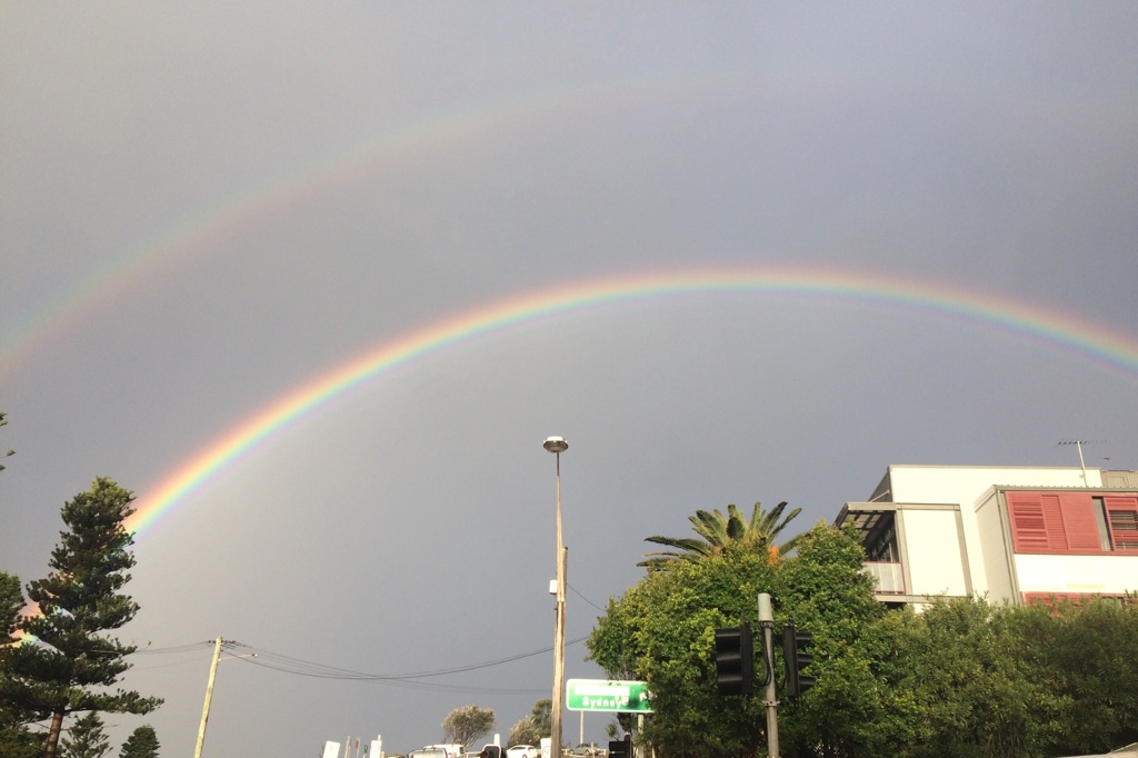
Photo by Bernadette Kelly, Friday August 5th
This great photo by a local student was taken at Avalon Beach on Friday afternoon. We all know it's been a but cold and damp this week, lots of snow for those who love skiing or tobogganing , and lots of rain for ducks to go paddling in.
Among all the showers there have been bursts of sun, which can make rainbows.
A double rainbow, or secondary rainbow, is caused by a double reflection of sunlight inside the raindrops, and are centered on the sun itself. They are about 127° (violet) to 130° (red) wide. Since this is more than 90°, they are seen on the same side of the sky as the primary rainbow, about 10° above it at apparent angles of 50–53°. As a result of the "inside" of the secondary bow being "up" to the observer, the colours appear reversed compared to the primary bow. The secondary rainbow is fainter than the primary because more light escapes from two reflections compared to one and because the rainbow itself is spread over a greater area of the sky. Each rainbow reflects white light inside its coloured bands, but that is "down" for the primary and "up" for the secondary.[25] The dark area of unlit sky lying between the primary and secondary bows is called Alexander's band, after Alexander of Aphrodisias who first described it.
Alexander of Aphrodisias was a philosopher and teacher. The term "philosopher" comes from the Ancient Greek word (philosophos) meaning "lover of wisdom". Its origination has been ascribed to the Greek thinker Pythagoras.
Alexander lived and taught in Athens at the beginning of the 3rd century, where he held a position as head of the Peripatetic school.
The school originally derived its name Peripatos from the peripatoi (Greek "colonnades") of the Lyceum in Athens where the members met. A similar Greek word peripatetikos refers to the act of walking, and as an adjective, "peripatetic" is often used to mean itinerant, wandering, meandering, or walking about.
Thanks Bernadette - great snap!NSW Report on Native Vegetation 2013-14 Released
Released 03 August 2016 by NSW Office of Environment and Heritage(OEH)
NSW Report on Native Vegetation 2013-14 (PDF, 6.8MB) is the fifth report to be released and combines four major reports relating to native vegetation management in NSW. These are the:
Native Vegetation Report CardPrivate Native Forest ReportNSW Woody Vegetation Change Report 2011–2013Compliance and Enforcement Report Card.
The Native Vegetation Report Card provides the latest information on the conservation, restoration, management and approvals for clearing native vegetation across NSW.
Over 200,000 hectares of native vegetation were conserved or improved across the State in 2013–14. In contrast, around 900 hectares were approved to be legally cleared where environmental values were maintained or improved through mechanisms such as the use of offsets.
The Private Native Forest Report discusses land managed under Private Native Forest (PNF) Property Vegetation Plans (PVPs). Around 41,000 hectares of land were approved during 2013–14 to be managed under PNF PVPs.
The NSW Woody Vegetation Change Report 2011–13 covers losses in woody vegetation due to clearing for agriculture, forestry and infrastructure activities. The total reduction in the area of woody vegetation in NSW from these activities over the period 2011–13 was 68,000 hectares or 0.08% of the area of NSW. The report also includes losses in woody vegetation resulting from bushfires. However, the report does not identify gains in woody vegetation due to planting and natural regrowth.
OEH and the EPA are responsible for implementing a credible compliance and enforcement framework to protect the environmental values of native vegetation and ensure that landholders who comply with the law are not disadvantaged.
OEH and EPA undertake this role through stakeholder engagement, strategic investigations, appropriate enforcement actions and targeted compliance campaigns. The Compliance and Enforcement Report Card provides information on OEH and EPA's compliance and enforcement activities.
Report 2013–14 demonstrates that extensive areas of native vegetation are being actively managed and conserved by farmers and rural landholders who understand the value in conserving remnant vegetation.
Previous versions of the report are available at the bottom of this webpage.Governments sits idle in the face of rampant illegal land clearing, new figures show
August 3, 2016: NSW Conservation Council Media ReleaseAlmost 60% of all the land clearing that occurred in NSW over a three-year period was “unexplained”, latest government figures reveal. [1]
The NSW Report on Native Vegetation 2013-2014, released by the Office of Environment and Heritage today shows 13,500ha of woody vegetation that was cleared for crops, pastures or thinning over the three years to 2013 was “unexplained”, and probably illegal.
The figures also showed “unexplained” clearing occurred on more than 4,400 properties, yet government agencies launched and completed only 818 compliance and enforcement actions in the same period.“This report shows that the Baird government is soft on illegal land clearing,” Nature Conservation Council CEO Kate Smolski. “We fear it is just a glimpse of what’s to come if the government introduces its new land-clearing laws with weaker environmental protections to parliament later this year.
“These figures show that the Baird government is not giving Local Land Services and other agencies the resources they need to monitor land clearing and to enforce the laws that are supposed to protect our soils, water resources and wildlife habitat.
“The area of woodland and wildlife habitat that has been illegally cleared is more than twice the size of Sydney Harbour, and would have provided habitat for thousands of native mammals.
“We in NSW are in the middle of an extinction crisis – we cannot afford to keep losing wildlife habitat at this rate or we will lose species like the koala forever. It’s a disgrace that the government continues to allow this to happen.”
Ms Smolski said the report also raised concerns about the ability of environmental agencies to detect and report on losses of bushland in a timely manner.
“It is troubling that the government is taking so long to collate data that the most up-to-date information in for some part of this report are from 2013. We are concerned that it will take years to detect the harm that its new laws will cause, and by then it will be too late to act.”
National Parks prepare for the approaching fire season
Media release: 2 August 2016Nearly 100 National Parks and Wildlife Service (NPWS) staff from the Metro North East Region will be participating in training on Wednesday 3 August at Lane Cove National Park in readiness for the upcoming fire season.
NPWS Metro North East Regional Manager, Peter Hay said the day is about refreshing NPWS staff skills for operations in fire emergencies for the coming fire season and importantly personal safety measures.
"Each year we apply different elements to keep it fresh, one of the most important activities this year is an "entrapment exercise" which is based on a fire overrun situation, which will be a practical session on how to deal with a scenario where a firefighting vehicle is overrun by fire," Mr Hay said.
"This session involves doing a number of specific activities within a set timeframe including donning all personal protective equipment, preparing the vehicle by starting the water pump, removing fuel containers from the vehicle, donning a protective blanket, closing vents, radioing for help and getting low down in the vehicle.
"It is very important that in the rare event of this happening, our staff are fully prepared."
This year's training will take place at Lane Cove National Park, in the centre of the Metro North East Region, which also provides an opportunity for staff not working in the park to familiarise themselves with surrounds and operational aspects of firefighting in the Lane Cove Valley.
This year's training also includes:• a practical session on 4WD vehicle recovery, including practising winching and use of other recovery gear;• a task-based fitness test, where staff must a pass a standardised test to be allowed to attend fires;• training in helicopter winching and safety around aircraft;• first aid certification;• checking all protective clothing and equipment;• checking the readiness of firefighting vehicles;• extra focus on management of hazardous trees to ensure everyone is aware of safe procedures for managing hazardous trees on the fireground;• information on the seasonal weather outlook for the next fire season, so everyone is aware of trends known to date.
The Metro North East Region Fire Preparation Day will be held Wednesday 3 August 2016 at Haynes Flat, Max Allen Drive, Lane Cove National Park.New wind energy framework to give certainty
01.08.2016: Ministerial Media Release- The Hon. Rob Stokes MP, Minister for PlanningA new wind energy planning framework will ensure that NSW has the right settings to attract investment in wind energy, while balancing the interests of the community. The new framework will address delays in the assessment process that in one case required more than 2500 days for a project to be determined. The average determination times for wind projects in the past five years has been more than 1000 days. Planning Minister Rob Stokes said the new framework is focused on driving better outcomes by encouraging proponents to engage early with the community. The policy framework has been developed in response to issues raised by community and industry around uncertainty in the application of the draft 2011 wind farm guidelines. Mr Stokes is inviting the community to have its say on the new planning framework. “We’ve consulted widely, including with key environmental groups, industry, other states and the Australian National Wind Farms Commissioner, to better understand the key issues in developing this framework,” Mr Stokes said. Overwhelmingly, the most contentious issues in dealing with wind projects are noise and visual impacts. The framework will provide guidance to the industry on how to better design their projects with these impacts in mind, in the context of environmental, social and economic impacts. It will provide greater certainty and consistency for the renewable energy industry and the community. Importantly, there will be no arbitrary buffer zones based on the height of turbines. For all other assessment requirements, wind energy developments will be subject to the same assessment framework as other State Significant Developments. “This new framework puts in place processes to identify potential impacts at an early stage to minimise conflict and delays,” Mr Stokes said. “The framework strikes the appropriate balance between giving clear guidance to industry whilst ensuring that the impacts of the project are assessed on their merit. “NSW has valuable wind and solar resources by international standards with many of the best areas located near existing electricity transmission infrastructure. The new framework will help NSW capture benefits from this industry and encourage investment in the State.” “We look forward to further engagement with community and stakeholders through the consultation period.” Submissions for the proposed wind energy framework can be made until 16 September 2016. The proposed new framework can be viewed at the link below or at the Department of Planning and Environment, 23-33 Bridge St, Sydney. Submissions can be made:• by post to Department of Planning and Environment, Attention: Director, Industry and Infrastructure Policy, GPO Box 39, Sydney NSW 2001• Submissions close on 16 September 2016.Muogamarra in bloom
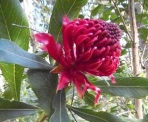 With spring just around the corner, it’s a great time of year to get outdoors in a national park and enjoy the crisp sunny days and beautiful blossoming flowers.
Muogamarra Nature Reserve, located in the northern outskirts of Sydney, transforms into a brilliant display of colour each August and September, when spring wildflowers come into bloom.
The reserve is only open for six weekends a year to preserve the fragile ecosystems and Aboriginal heritage, and this year, will be open each Saturday and Sunday from 13 August to 18 September.
The best way to explore the extraordinary nature reserve is on a special guided tour. There are three guided walks on offer, where you’ll see and learn about the reserve’s spectacular plants and enjoy stunning scenery.Or for the more adventurous, join the full-day 18km kayaking tour along the Hawkesbury River to see the reserve from the shoreline, take in the sheer cliffs and learn about the area’s fascinating history.
Challenge yourself on The Coast trackLooking for a walking adventure close to Sydney? The Coast track in Royal National Park, just one hour south of the CBD, is definitely one for your to-do-list.
You’ll walk along cliffs, beaches and escarpments, taking in magnificent ocean views and the rugged beauty of the coastline as you go.The 26km track can be walked over two days, combined with an overnight camping experience, or broken up into a series of day walks.
There’s also been no better time to lace up the boots and set out, as the track has recently undergone a $1.8 million upgrade over nine months. Works included construction of sandstone stairways and installation of 2.2km of new boardwalk at several sites.
This work has enhanced the walking experience for visitors, but has also prevented soil erosion and protected coastal vegetation.
The Coast track will also benefit from the recent funding announcement from the NSW Government, with $3.6 million allocated for the next 12 months and $9 million over four years.
 With spring just around the corner, it’s a great time of year to get outdoors in a national park and enjoy the crisp sunny days and beautiful blossoming flowers.
Mining The Sun
Published on 27 Jul 2016 by The Climate CouncilThe solar revolution is already here – even in Australia’s most famous mining town!Find out more at: www.climatecouncil.org.au/mining-the-sunTrees on farms: The missing link in carbon accounting
August 2, 2016While tropical forests continued to decline, a remarkable change is happening: tree cover on agricultural land has increased across the globe, capturing nearly 0.75 Gigatonnes carbon dioxide every year. A new study titled "Global Tree Cover and Biomass Carbon on Agricultural Land: The contribution of agroforestry to global and national carbon budgets" provides insights into the patterns of this tremendous change at global, regional and national scales.
According to the International Panel on Climate Change (IPCC), agriculture and land-use change account for about 24% of the world's greenhouse gas emissions. Climate change will also have strong impacts on food security in the long-term. Therefore agriculture needs to reduce its climate footprint. But a recent study has shown that the potential to reduce greenhouse gas emissions from crop and livestock production is limited. At the same time, large forest areas, primarily in the tropics, are still being converted into agricultural land to feed the world's growing population.For these reasons, agricultural practices that can significantly reduce carbon emissions are in high demand.
Trees on agricultural lands -- also known as agroforestry systems -- have the potential to contribute to climate change mitigation while improving livelihoods and incomes and providing invaluable ecosystem services at the same time. The World Bank estimates that globally 1.2 billion people depend on agroforestry farming systems, especially in developing countries. However, trees on agricultural lands are not considered in the greenhouse gas accounting framework of the IPCC.
A team of researchers from various institutions in Africa, Asia and Europe carried out a study to assess the role of trees on agricultural land and the amount of carbon they have sequestered from the atmosphere over the past decade. The study, entitled "Global Tree Cover and Biomass Carbon on Agricultural Land: The contribution of agroforestry to global and national carbon budgets," looks at biomass carbon on agricultural land both globally and by country, and what determines its distribution across different climate zones.
Biomass on agricultural land globally"Remote sensing data show that in 2010, 43% of all agricultural land globally had at least 10% tree cover, up from eight percent in the preceding decade," said Robert Zomer of the World Agroforestry Centre, lead author of the study. "Given the vast amount of land under agriculture, agroforestry may already significantly contribute to global carbon budgets."
However, regional differences in the trend are significant. The distribution of tree cover on agricultural land depends on climatic conditions in different parts of the world. High tree cover is found in humid areas such as South East Asia, Central America, eastern South America, as well as central and coastal West Africa. Tree cover on agricultural land was moderate in south Asia, sub-humid Africa, central and western Europe, the Amazonia and mid-west North America. On the other hand, low tree cover was found ineast China, northwest India, west Asia, the southern border of the Sahara Desert, the prairies of North America and southwest Australia.
Biomass on agricultural land by countryRemarkable differences are noted in changing biomass carbon stocks over time among countries. Brazil, Indonesia, China and India had the largest increases, while Argentina, Myanmar, and Sierra Leone had the largest decreases in biomass carbon stored on agricultural land.High average carbon mass levels were to be found in 26 countries in the humid tropics, with the Democratic Republic of Congo, Papua New Guinea, Malaysia and Indonesia in the lead. On the other hand, 60 countries found in arid and desert parts of the world around the Sahara Desert in North Africa, the Kalahari in southern Africa, Middle East, as well as central and southern Asia recorded low carbon levels over the ten-year period.
"Study results show that existing tree cover makes a major contribution to carbon pools on agricultural land, demonstrating the potential to add to climate change mitigation and adaptation efforts," said Jianchu Xu of the World Agroforestry Centre. "If tree cover is accounted for, the total carbon stock is over four times higher than when estimated using IPCC tier 1 estimates alone."
Given the large amount of agricultural land where tree cover is below its potential, the study suggests that a huge mitigation potential exists and should be explored more systematically.
"The results of our spatial analysis show that trees on agricultural land sequestered close to 0.75 Gigatonnes of carbon dioxide globally per year over the past decade," said Henry Neufeldt, Head of Climate Change research at the World Agroforestry Centre. "If we can harness good policies to enhance positive examples and stop negative trends, trees in agricultural landscapes can play a major role in greenhouse gas mitigation. But no one should say that this is already solving the problem for agricultural emissions as long as we do not know what is actually happening on the ground."
Robert J. Zomer, Henry Neufeldt, Jianchu Xu, Antje Ahrends, Deborah Bossio, Antonio Trabucco, Meine van Noordwijk, Mingcheng Wang.Global Tree Cover and Biomass Carbon on Agricultural Land: The contribution of agroforestry to global and national carbon budgets.Scientific Reports, 2016; 6: 29987 DOI: 10.1038/srep29987
Court gives green light to CSG water treatment facility near Narrabri
August 1, 2016: EDO Media ReleaseToday the Land and Environment Court gave a green light for Santos to operate its 'Leewood' coal seam gas (CSG) wastewater treatment facility near Narrabri and the world-renowned Pilliga State Forest in North-West NSW.
Community group People for the Plains – represented by public interest environmental lawyers EDO NSW – argued that the Leewood facility is unlawful because it did not go through the proper assessment process before being approved. The facility was approved in August 2015 by the NSW Department of Industry without an Environmental Impact Statement (EIS) being prepared and without the public being given a chance to comment.
However, the Land and Environment Court decided that the approval was valid, meaning that the facility can now begin operation. It is expected to treat up to 1.5 million litres of CSG wastewater every day.
“Our client is very disappointed by this decision,” said Sue Higginson, EDO NSW CEO/Principal Solicitor. “People for the Plains was fighting for the community’s right to have a say about the facility and to ensure a comprehensive assessment of its environmental impacts was conducted.”
“Our client and others in the local community are worried about the impacts the facility will have on the ecosystems of the Pilliga. Such a large industrial waste treatment facility does not fit within the ordinary understanding of CSG exploration. Developments of this scale normally require a rigorous assessment process, where the community is given the chance to have their voice heard. This development is a significant addition to CSG activities in the area, and is one of a number of incremental CSG projects that represent not only a growing presence of the industry in this biodiverse region, but also a new threat to one of Australia’s important natural environments.”
“The public exhibition of major developments is a key foundation of a well-functioning planning system. It’s a right that has been embedded in Australia’s environmental law since the ‘70s, for good reason: public participation brings about better planning decisions and ensures transparency and accountability. Without this fundamental right, we’d be a much poorer nation.”
“This is a complex area of the law, and we’ll be looking very closely at the judgment to explore our client’s options for appeal.”
For background on this case:www.edonsw.org.au/people_for_the_plains_v_santos_and_ors
Sydney Harbour Trust Oral History Project
29 July 2016: Sydney Harbour TrustDo you have a connection to a Harbour Trust site?If so we’d love to hear it. The Sydney Harbour Federation Trust is gathering the stories of those who lived or worked at Harbour Trust managed sites.
Were you based at North Head or Georges Heights? Did you work on ships at Cockatoo Island? Did you serve at HMAS Platypus or attend ASOPA? Maybe you were one of the lucky few who lived at one of these sites.
A Harbour Trust oral history volunteer would love to interview you and hear your tales of work and life. Whether you were a boiler maker, soldier, shipwright, secretary, student or management, your story is important in preserving the history of these sites for future generations who have never known them as working, active hubs.
If you, or someone you know, would like to be interviewed please emailcatherine.enright@harbourtrust.gov.au or call (02) 8969 2112 for more information and to book in an interview. Interviews are approximately 1hr long and are conducted at Georges Heights or Cockatoo Island. We look forward to hearing from you.
Revealing Caspian seal migration and foraging behaviour through satellite telemetry
Published August 4, 2016: by University of LeedsA brief introduction to how satellite telemetry has been used to investigate the migration and foraging behaviour of Caspian seals, including a visualisation of animated seal telemetry tracks.
Dr Simon Goodman from the Faculty of Biological Sciences at the University of Leeds, who led the study, said: “Some of the findings really surprised us – for instance one seal swam 14,400km in a year, and many of the seals we tracked during the summer stayed at sea for around 6 months without coming back to land.
"It was also remarkable how much difference in behaviour there was between individual seals.”
As well as giving insights into the ecology of seals, this work provides vital information for conservation efforts.
Caspian seals are listed as an endangered species by the International Union for the Conservation of Nature and their population has dropped by 90 per cent in just over 100 years, from more than one million at the start of the 20th century.
This was primarily due to intensive hunting, which lasted until the early 1990s, but the main threats now come from drowning in fishing nets set by sturgeon poachers, habitat loss and other disturbance from human activities.
"The data from telemetry studies such as this can help identify key areas of seal habitat which might be incorporated into future protected areas, and planning other human activities, such as oil and gas developments so they don’t impact on seals,” said Dr Goodman.
“To date there have been limited efforts to protect Caspian seals from their many threats, but this is the kind of information needed to help prioritise areas for special protection, and how to most effectively set up and manage them.”
The study was led by researchers from the University of Leeds, together with scientists from Estonia, Kazakhstan, Russia and Northern Ireland. The video accompanies a scientific paper describing the full study:
Dmitrieva et al. 2016. Individual variation in seasonal movements and foraging strategies of a land-locked, ice-breeding pinniped. Marine Ecology Progress Series 554: 241–256. doi: 10.3354/meps11804.
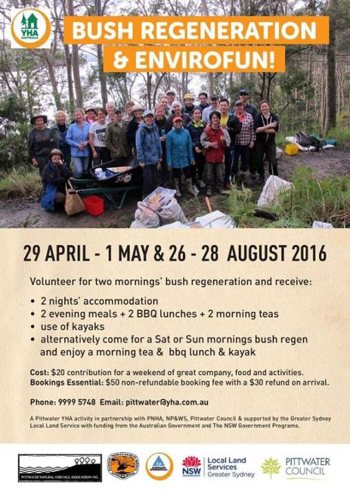
Bush Regeneration And Envirofun Weekend
On: August 26-28, 2016At: Pittwater YHA, Morning Bay
Volunteer for two mornings’ bush regeneration and receive free accommodation, two evening meals, two BBQ lunches and two morning teas and free use of kayaks over the weekend of 26 to 28 August. Alternatively come for a Saturday or Sunday morning bush regeneration and enjoy a morning tea and BBQ lunch and kayak. It is only a $20 contribution ($50 nonrefundable booking fee with a $30 refund on arrival) for a weekend of great company, food and activities.
Bookings essential: 9999 5748 Email: Pittwater@yha.com.au
A Pittwater YHA activity in partnership with: • Pittwater Natural Heritage Association • National Parks and Wildlife Service • Northern Beaches Council • supported by the Greater Sydney Local Land Service • with funding from the Australian Government and the NSW Government.

First Southern Right Whale Spotted Off Sydney
Media release: NPWS 2016The National Parks and Wildlife Service (NPWS) has welcomed the arrival of southern right whales off the NSW coast again this year after one was spotted entering Botany Bay today just off the coast of Sydney.NPWS Wildlife Management Officer Geoff Ross said it's great to see southern right whales in NSW waters again and it is a timely reminder that we share our harbours, bays and oceans with these majestic animals.
_(16172696979).jpg?timestamp=1469845750201)
"Every year we are seeing more southern right and humpback whales pass the NSW coast as their populations recover and they are regularly sheltering in our estuaries, harbours and major waterways, even busy Sydney Harbour," Mr Ross said.
"The recent sightings of the southern right is very exciting as it means that the species is slowly returning to their traditional places in NSW bays and inlets. These sheltered bays and inlets were traditional calving areas for right whales and we are seeing them return home after whaling pushed them to the brink of extinction.
"With infrastructure, people and large numbers of commercial and recreational vessels making the formerly quiet bays and inlets of the NSW coast now very busy, we need remind people to give these whales space and share the water. Southern rights love the shallow water, are hard to see and they travel slowly making them more vulnerable to vessel strike and entanglement.
"For the safety of the whales and the boating community, Masters should ensure their vessels stay 100m from a whale or 300m when a calf is present or the vessel is a jet ski.
"If you're swimming, diving or just enjoying the water on your own or with friends and you spot a whale, then you must stay at least 30m from the whale in any direction.
"While the humpback whale population is recovering strongly, with an estimated 24,000 individuals in the wild, sightings of the southern right whales close to shore is significant as their numbers are still very low especially in NSW waters where aerial surveys over the past four years have counted only 17 right whales."
"We can individually identify right whales by the shape and pattern of their callosities (hard growths on their head) so NPWS is working with university researchers to obtain photographs of the whales using remotely piloted aircraft or UAVs (Unmanned Aerial Vehicles).
"These photos will then be added to the Australasian Right Whales Photo Identification Catalogue (ARWPIC) providing wildlife managers with important information," Mr Ross said.
For more information on whales visit the NPWS Wild about Whales website and download the App to record your sightings. Alternatively visitwww.orrca.org.au
Whale Facts• For all vessels, a distance of between 100m and 300m is established as the 'caution zone'. In this zone, vessels must travel at a constant slow speed and leave a negligible wake. It's also important to assess the direction that the whales are travelling in, and then plan the best course of action.• These animals can be unpredictable in their behaviour so NPWS remind other UAV users to maintain aircraft approach distances. If you're flying a UAV or a plane, or helicopter and you spot a whale, then you must be at a height no lower than 300 metres; within a horizontal radius of 300m for aircraft, and for helicopters, gyrocopters and UAVs, the distance increases to 500m.• If you see a stranded, entangled or sick whale in distress, please report it immediately to the NSW National Parks and Wildlife Service or ORRCA.• The southern right whale is a baleen whale and one of three species classified as right whales. This species is easily distinguished from others because of their broad back without a dorsal fin, wide pectoral fins, a long arching mouth that begins above the eye and small rough patches of skin (or callosities) on its large head. Its two separate blow holes produce a distinguishing V-shaped blow.• Land-based whaling in Australia initially concentrated on southern right whales. They get their name because they were the 'right' whale to catch: they were slow-swimming, floated when dead, and provided large amounts of valuable products - particularly oil for illumination and lubrication.• Commercial whaling began in Australia in 1820, taking around 75% of the southern right whale population between 1835 and 1845, when the industry collapsed. It took another 90 years before they were officially protected.• An estimated 12,000 southern right whales are spread throughout the southern hemisphere, compared to an original population before whaling of more than 100,000. However, their numbers are growing at around 7% each year.
Southern Right Whale (Eubalaena australis) Courtesy Photo Gregory "Slobirdr" Smith -
_(16172696979).jpg?timestamp=1469845750201)
Katandra Sanctuary

Katandra is a sanctuary for flora and fauna where the wildflowers are their most colourful during spring but all year round there are opportunities for bird watching. The sanctuary covers 12 hectares and is situated on the Ingleside/Warriewood escarpment. Choose to follow a short walk of about 1km or the longer 2km track through rainforest remnants with creeks and fern-fringed pools. Visit: www.katandra.org
SUNDAY MORNING BIRDWATCHING with PNHA
Would you like to know more about our local birds and explore our bushland reserves? Then join us on one of our bird walks:
21 August, Chiltern Track, Ingleside (birds and wildflowers)
25 September, Irrawong Reserve, North Narrabeen
27 November, Warriewood Wetlands
Most walks start at 7.30 or 8am and last a couple of hours. Bring binoculars and morning tea for afterwards if you like. Contactpnhabirdwatching@gmail.com for details of each walk.
Have Your Say On Wyong Coal Mine
Wallarah 2 Coal ProjectEstablishment of an underground coal mine and associated infrastructure (see Preliminary Environmental Assessment). The proposal will also require Commonwealth assessment under the EPBC Act.
Exhibition Start 22/07/2016Exhibition End 05/09/2016
City WyongState NSWPost Code 2259Country AustraliaLocal Governments Lake Macquarie City Council and Wyong Shire Council
All Documents at: majorprojects.planning.nsw.gov.au/index.pl?action=view_job&job_id=4974 Amended application Document: HERE
The key features of the Project include:
• A deep underground longwall mine extracting up to 5 Million tonnes per annum of export quality thermal coal; • The Tooheys Road Site (located north-east of the intersection of the M1 Motorway and the Motorway Link Road) which includes a portal, coal handling facilities and stockpiles, water and gas management facilities, small office buildings, workshop, coal transportation infrastructure and connections to municipal water and sewerage systems; • The Buttonderry Site (near the intersection of Hue Hue Road and Sparks Road) which includes administration offices, bathhouse, personnel access to the mine, ventilation shafts and water management structures; • The Western Ventilation Shaft Site (located in the Wyong State Forest) includes a downcast ventilation shaft and water management structures; • An inclined tunnel (or ‘drift’) from the surface at the Tooheys Road Site to the coal seam beneath the Buttonderry Site; • Transportation of product coal to the Port of Newcastle by rail; and •An operational workforce of 300 full time employees.
The Project constitutes State Significant Development. As such, the Project has been subject to the assessment process under Division 4.1 of Part 4 of the Environmental Planning & Assessment Act 1979.Have your Say on Springvale Coal Mine
Modification to Springvale Extension ProjectExhibition Start 02/08/2016Exhibition End 23/08/2016
Proposed modification to Springvale Mine's consent SSD 5594 to (i) increase run of mine coal production limit from the approved 4.5 Mtpa to 5.5 Mtpa, (ii) increase workforce from the approved 310 full time equivalent personnel to 450 full time equivalent personnel, (iii) increase coal stockpile capacity at the Springvale pit top from the approved 85,000 tonnes to 200,000 tonnes. Amend applicant name on SSD 5594 from 'Centennial Springvale Pty Limited' to 'Springvale Coal Pty Limited'.
Visit: Antarctic sea ice may be a source of mercury in southern ocean fish and birds
August 1, 2016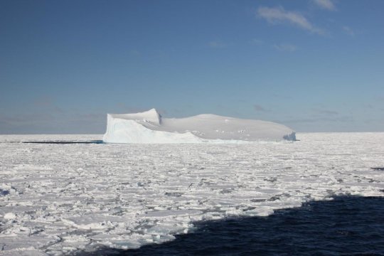
Credit: Caitlin Gionfriddo, University of Melbourne
New research has found methylmercury -- a potent neurotoxin -- in sea ice in the Southern Ocean.
Published today in the journal Nature Microbiology, the results are the first to show that sea-ice bacteria can change mercury into methylmercury, a more toxic form that can contaminate the marine environment, including fish and birds.
If ingested, methylmercury can travel to the brain, causing developmental and physical problems in foetuses, infants and children.
The findings were made by an international team of researchers led by Ms Caitlin Gionfriddo and Dr John Moreau from the University of Melbourne, and also included scientists from the Centre for Systems Genomics at the University of Melbourne, the US Geological Survey and Lawrence Livermore National Lab.
Methylmercury builds up in the food web through a process called 'biomagnification', said Ms Gionfriddo, PhD candidate from the School of Earth Sciences, University of Melbourne.
"Larger fish eat smaller contaminated fish, and continuously accumulate methylmercury at harmful levels for human consumption," Ms Gionfriddo said.
The team wanted to understand more about how the most toxic form of mercury enters the marine environment, and the food we eat.Ms Gionfriddo spent two months aboard the icebreaker Aurora Australis to collect samples of Antarctic sea ice during an expedition mounted by the Australian Antarctic Division.
The ice was analysed for different forms of mercury, including methylmercury, at the US Geological Survey in Wisconsin (USA). The DNA and proteins from sea ice microorganisms were studied at the University of Melbourne (AUS) and Lawrence Livermore National Lab (USA).
Mercury is a heavy metal pollutant that can be released into the environment through volcanic eruptions and re-released from vegetation during bushfires. It is also created through human activity, such as gold smelting and burning fossil fuels.
University of Melbourne geomicrobiologist and team leader, Dr John Moreau, said that the results confirmed the presence of bacteria in the sea ice with the genetic ability to convert mercury into the more toxic form.These findings highlight the importance of eliminating mercury pollution from the environment, and following current recommendations to limit consumption of certain types of fish[1], say the researchers.
"These results are the first to identify a particular genus of bacteria, Nitrospina, as capable of producing methylmercury in Antarctic ice," Dr Moreau said.
"The presence of these potential mercury-methylating bacteria raises an interesting question," he added. "Could they also play a role in forming the methylmercury observed in the oceans worldwide?"
The team are keen to understand this process in the next steps of their research.
"Mercury has a long lifecycle in the atmosphere, up to a year," said co-author Dr Robyn Schofield. "This means that mercury released through fossil fuel burning from countries over 3000 km away goes up in the atmosphere and ends up in Antarctica."
"The deposition of mercury into the sea occurs all year-long but increases during the Antarctic spring, when the sunlight returning causes reactions that boost the amount of mercury that falls onto sea ice and the ocean," Ms Gionfriddo added.
"We need to understand more about marine mercury pollution," said Dr Moreau, "Particularly in a warming climate and when depleted fish stocks means more seafood companies are looking south."
This project was supported through funding from the Australian Government's Antarctic Science Grant Program (AAS4032) and The University of Melbourne Joyce Lambert Antarctic Research Seed Funding Grant (no. 501325).
[1]. Source: Food Standards Australia and New Zealand
Caitlin M. Gionfriddo, Michael T. Tate, Ryan R. Wick, Mark B. Schultz, Adam Zemla, Michael P. Thelen, Robyn Schofield, David P. Krabbenhoft, Kathryn E. Holt, John W. Moreau. Microbial mercury methylation in Antarctic sea ice. Nature Microbiology, 2016; 1: 16127 DOI:10.1038/nmicrobiol.2016.127

Independent Review Of Toxicity Levels Of PFAS Chemicals
New South Wales Senators Have Been Decided
Consul-General In Phuket
New Funding To Support Ex-Police Officers
New Courses On The NSW Skills List
No Heritage Listing For Sirius Building
1930'S Car Dashcam
Budding Filmmakers At The 1956 Olympics
Sir Robert Menzies
Check Your Water Quality Online

Avoid Recalled Rockmelon After Salmonella Outbreak: NSW Health
Doctors To Prescribe Cannabis-Based Medicine
Bankstown-Lidcombe Hospital Interim Report
- Every medical gas outlet installed in a NSW Health facility in the last five years is being checked to ensure the correct gas is being emitted.
- This state-wide audit of gas emissions has been extended to every medical gas outlet in NSW, irrespective of when it was installed.
- Any future upgrade to medical gas outlets in a NSW public hospital will be required to undergo independent verification.
Revolutionary WIFI Invention Selected for World in 100 Objects Exhibition

Disclaimer: These articles are not intended to provide medical advice, diagnosis or treatment. Views expressed here do not necessarily reflect those of Pittwater Online News or its staff.