Reporting seabird mortalities to Adrift Lab: this event may impact other seabirds, persist until end of summer with warming eddy current off our shores
+ Scientists Voyage To The Southern Ocean To Investigate How Climate Change Impacts The Planet's Strongest Current
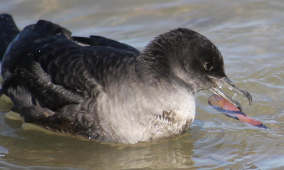
On Friday November 17 2023 one of Adrift Lab’s long-time project partners Silke Stuckenbrock found a Flesh-footed Shearwater washed up dead on a north Sydney beach - here on our peninsula. The bird had an ABBBS metal band attached to its leg and Adrift Lab was the one who attached the band. This bird was one of their study birds on Lord Howe Island and tragically, had just reached breeding age. The project has been running for 16 years and this is the first time one of their banded Shearwaters has been found during a wreck event.
This speaks to the important role you all play as Citizen Scientists. You are the eyes and ears for Australian science right now. On Thursday November 16 Adrift Lab received 30-40 submissions.
Adrift Lab is asking all of us to keep an eye out for birds and report them, with a photo, to them.
Please email: adriftlab@gmail.com or direct message via any of Adrift Lab's social media channels (you can also reply to one of their existing posts). Adrift Lab are on Facebook - Instagram and Twitter
If you find a muttonbird (or any bird) with a metal ring on its leg, please report the number to the Department of Climate Change, Energy, the Environment and Wate's Australian Bird and Bat Banding Scheme.
In 2013, millions of muttonbirds starved along Australia’s coast from K'gari/Fraser Island to Tasmania - Pittwater Online reported their presence in the Pittwater estuary and along our beaches during that 2013 event.
The University of Tasmania's Dr. Lauren Roman, a researcher at the Institute for Marine and Antarctic Studies, explained in a November 2023 report for The Conversation that why they don’t know the exact cause of the 2013 loss of thousands and thousands of birds, this was likely influenced by a double whammy: competition for food with salmon and a severe marine heatwave called “the blob”.
''To take pressure off wild fish stock and meet soaring demand, salmon hatcheries now release billions of fry, many more than would exist through nature, into the North Pacific Ocean. Pink salmon numbers, both hatchery and wild fish, have more than doubled in recent decades.
Increased salmon numbers have caused crashes in zooplankton in odd-numbered years, when most pink salmon reach spawning size and are 25 times more abundant than in even-numbered years. The effect is so strong that even healthy breeding muttonbirds arriving in Tasmania are lighter most odd-numbered years.'' Dr. Roman said
Now another ocean warming event is occurring off Sydney.
The fallout from their gruelling 16,000km long journey usually occurs at sea; however, recent weather conditions have caused the seabirds to wash ashore according to some theories.
Adrift Lab Wildlife ecologist Jennifer Lavers, who specialises in seabirds, said she did not believe the deaths were due to an isolated storm event because the birds had evolved to survive extreme conditions. Ms Lavers has said it was more likely the giant eddy off the coast of Sydney generating a massive sea warming which has put regular food sources out of reach.
"These marine heatwaves, or the eddy structures, are basically like forest fires but in the ocean," she said. ''Seabirds are the marine equivalent of the “canary in the coal mine” and we should be listening to what they’re telling us. What's causing the deaths is a large Marine Heatwave off the east coast of Australia.''
''Here are a few explanatory sentences from the paper we published in 2021 [A proposed framework for reporting mass mortality (wreck) events of seabirds]'':
Ocean temperatures are rising due to climate change, and extreme events such as marine heatwaves are increasing in frequency, subsequently influencing the abundances of marine predators and their prey. Marine heatwaves, along with a broad spectrum of additional threats, are causing many seabird populations to decline. Most of these threats are synergistic or cumulative, and virtually all are increasing in their frequencies and intensities. Although storms and strong winds may increase the likelihood of birds washing up, the cause is most likely related to a shortage of food reducing the bird’s condition.
Anomalous oceanic conditions and climatic phenomenon, such as El Niño-Southern Oscillation (ENSO), have also been shown to impact seabird survival often resulting in wreck events. Seabird wrecks caused by environmental variables appear to have increased in frequency in some areas. Such events highlight the impact of environmental pressures that birds are facing globally, which are now exceeding the ability of many species to cope. Monitoring beach-washed seabirds, including those species that migrate, can provide insights into the spatial and temporal extent of wrecks and other anomalous events.
University of NSW Oceanographer Moninya Roughen has said the eddy extended 400 kilometres east into the Tasman Sea and was three kilometres deep. She said it increased the water temperature by about three degrees Celsius and that warmer water could destroy ocean habitats.
"That's the basis of where we get our fisheries … the habitat dies and the fish disappear," Ms Roughen said.
The substantial marine heatwave during the summer of 2013/2014 resulted in the deaths of an estimated 200,000 shearwaters that washed up from Brisbane to Hobart.
In 2013, the wreck event started with Short-tailed Shearwaters, but after a few weeks, other species started to be impacted too - this may also happen this year and into January 2024 when the heatwave in the waters off our coasts is expected to peak. This is why Adrift Lab are requesting photos when you submit your data (to confirm ID).

Millions of short-tailed shearwaters (Ardenna tenuirostis), commonly known as muttonbirds, return to southern Australia from the Arctic each spring – a round trip of up to 35,000km. Not all birds survive their long migration. The fit and healthy largely return in late September and October. The less fit lag behind. To some extent, deaths are natural.
Muttonbirds keep a strict timetable and, while failed migrants can wash up any time during Spring, mass mortalities can occur from mid-October to November. Muttonbird wrecks have happened on rare occasions since time immemorial, but are becoming more common.
The many ideas about what is causing wrecks range from storms and overfishing to plastic, blue-green algae and irradiated water from Fukushima.
University of Tasmania researchers have studied the muttonbirds for decades. While they can’t pinpoint the exact cause for every wreck, they can explain what we know and eliminate the unlikely culprits.
What the UTAS Knows
Dr. Lauren Roman:
''When muttonbird wrecks occur, the casualties are starving. These birds weigh only half their healthy body weight. The factors leading to this starvation start before they reach Australia
Muttonbirds chase an eternal Summer. After returning to Australia from the North Pacific, they lay eggs in late November on Australia’s southern islands and raise a single chick. When the weather cools in April the adults depart on a great migration north where the sea ice is melting on the Bering Sea ahead of an Arctic summer.
Ecosystem changes in the sub-Arctic, where the birds fatten up over the northern Summer, can lead to death on Australian beaches.
Many marine animals share the North Pacific Ocean with muttonbirds. Among them are several salmon species, which compete with muttonbirds and other marine wildlife for the same zooplankton prey – the abundant small animals floating in the surface waters of the ocean. The pink salmon (Oncorhynchus gorbuscha), in particular, is central to the muttonbirds story. You may have seen them in documentaries, being eaten by bears on the annual “salmon run”. You may also eat them yourself, as tinned salmon.
Pink salmon live hard and fast. Their life cycle from hatching to spawning lasts two years. However, wild numbers couldn’t satisfy consumer demand and by the mid-20th century the species was in trouble and the releasing of billions of fry, described above, commenced.
Other factors are also affecting zooplankton. The Arctic seas are among the fastest warming on Earth. Marine heatwaves have been causing shifts in where and when zooplankton occur, and how large they grow.
When seabirds on a strict schedule arrive to feed, they can miss the zooplankton buffet. This has led to devastating wrecks for Arctic and sub-Arctic seabird species, including muttonbirds.''
Readers have sent in emails asking could these birds have died from Avian Flu (HPAI), as has been recorded for numerous other seabird species in the Northern Hemisphere South America and Antarctica over the past 2 years.
Adrift Lab states the answer to this question is not straightforward, unfortunately.
''So far, nearly 1000 Short-tailed Shearwaters and other seabird species in Australia have been tested and, thankfully, the results are all negative. That does not mean, however, that we are fully in the clear and we should continue to take precautions.
Monitoring and testing is ongoing - we assure you multiple teams of exhausted (and sad) scientists are putting in some very long hours to keep on top of this as best they can.''
Dr. Lavers has said people should not touch the birds without personal protective equipment — or let their dogs near them — because disease could not be ruled out.
"There are no signs at this stage that avian flu has reached Australia, but we just want to be cautious," she said.
WIRES asks people who find an exhausted shearwater or any other seabird that is still alive to call WIRES on 1300 094 737 or contain in a box and take to the nearest vet. Do not attempt to feed or give water, keep it warm and quiet away from pets and children. These birds cannot fend for themselves and could be attacked by dogs and foxes, leaving them to die of horrific injuries.
Regular contributing photographer Joe Mills sent in his batch of images for 'Turimetta Moods' for the week ending November 10 2023 with this tragic note:
''It was a sad week as there were about 20 Shearwaters washed up on the beach, and I had to walk past them every morning. By Friday they were starting to be buried by the sand. I read your PON article, and I tend to agree that exhaustion through storms and lack of food due to deep warm water columns was probably the cause. My other concern is that if 20 birds were lost on only one beach (Turimetta), then there must have been thousands which may have perished further down their southern flight path.'' Joe said
Joe's quote for that soon to run Turimetta Moods catch-up round:
It is not a coincidence both birds & angels have wings. - Unknown
A monster eddy current is spinning into existence off the coast of Sydney. Will it bring a new marine heatwave?

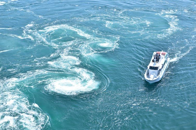
Right now, there’s something big spinning off the coast from Sydney – a giant rotating vortex of sea water, powerful enough to dominate the ocean currents off south-eastern Australia.
Oceanographers describe these spinning water bodies as “eddies” – but they’re not the small eddy currents you see in creeks or rivers. Ocean eddies are enormous. They’re usually hundreds of kilometres across (100–300km), up to 2km deep and can be visible from space.
It turns out these eddies drive change underwater by spawning marine heatwaves. Our new research demonstrates the link between a warm ocean eddy and a record-breaking marine heatwave which struck off Sydney from December 2021 to February 2022.
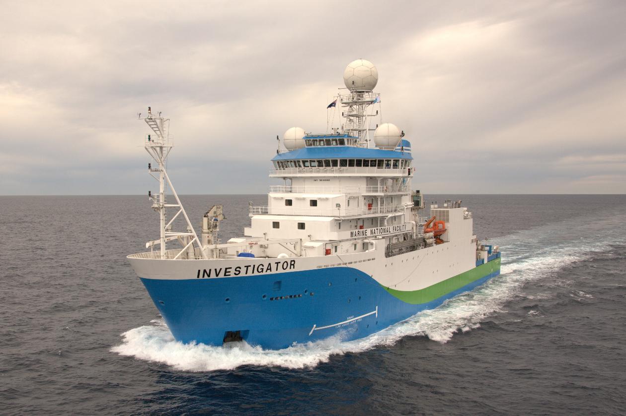
Now it’s happening again. An even bigger eddy is forming about 50km off Sydney. We have just returned from a 24-day research voyage on CSIRO’s research vessel RV Investigator to explore this monster eddy.
Our estimates suggest this 400km wide beast holds 30% more heat than normal for this part of the ocean. Its currents are spinning at 8km per hour. And the temperatures deep underwater are up to 3°C above normal. If it moves close to shore, it could trigger another coastal marine heatwave.
How can an eddy current make a heatwave?
Eddies are the ocean equivalent of storms in the atmosphere. Like weather patterns, they can be warm or cold. But ocean eddies can shape the ocean’s patterns of life.
Warm eddies are like ocean deserts with little life, while cold eddies are typically much more productive. That’s because they draw up nutrients like nitrogen and phosphorous from the deep sea, which become food for plankton.
Just as storms can in the atmosphere, ocean eddies can drive extreme “ocean weather”. That’s because warm eddies can bring in masses of warm water and keep it there for months. Sea life is often very finely attuned to temperature, so a sudden heatwave like this can heavily impact ecosystems.
It’s important to better understand how eddy currents grow, move and decay better. That’s because they can store large amounts of heat and can temporarily increase coastal sea levels.
What we do know is that warm eddies along Australia’s east coast can be fed by the East Australian Current when it becomes unstable. The current wobbles back and forth until eventually the wobbles form a coherent circle – an eddy – or adding to an existing one. It’s like a garden hose thrashing around on the grass when the flow is too great. These unstable currents can be small, on the kilometre scale, or huge.

Our research pinpointed the root cause of the 2021 marine heatwave off Sydney. A large warm eddy formed. But it couldn’t spiral away into deeper waters, because there were cold eddies to the north and south preventing it. That’s very similar to what can happen in the atmosphere, where a high pressure system can be held in place by other weather systems.
Now, it looks as if history is repeating.
Over the past month, an enormous eddy – fully 400km wide and 3km deep – has been spinning up just off southeastern Australia. It’s being fed by the warm East Australian Current, which brings warm water from the tropics down to more temperate waters. This eddy is bigger and warmer than most eddies in the region, especially at this time of year. It has been growing over the past month, and is pushing up against cold waters to the south. Where the two systems meet there are very strong temperature differences – up to 5°C over just 4km.
You can get some insight into how eddy currents behave from satellites.
Our trip on the research vessel RV Investigator made it possible for us to grasp how this powerful current was behaving – in three dimensions.
We also released drifters, GPS-tracked buoys which float around the eddy centre in a massive circle. Some have been carried more than 2,000km in the last month, passing where they originally started. Others have escaped the eddy and headed east into the Pacific.
These sensors and instruments have given us vital information. Now we know the water in the eddy is flowing at a fast walking pace, around 8km per hour. And we know that while the currents within the eddy are rotating quickly, the eddy itself has remained fairly stationary off the NSW coast, growing with warm waters from further north.
We also deployed five diving Argo floats. Satellite data shows us surface temperatures in the eddy have hit 23°C, two degrees above average for a month. But Argo floats show us the temperatures are even more extreme 500m below the surface, more than 3°C above average.
What happens to eddies? Like atmospheric systems, these are effectively heat engines. They transport heat to new areas as they whirl in the ocean. While they hold heat a long time, eventually it’s lost to the atmosphere and through mixing at the edges of the current. Eventually, they disappear.
But as we head into summer, the mega eddy is unlikely to go anywhere. If it moves towards the coast, where marine life is concentrated, we will see water temperatures spike – and possibly, underwater disaster for many species.
We would like to thank the RV Investigator’s Master, Captain Andrew Roebuck, Deck Officers and crew and the CSIRO technical staff.![]()
Moninya Roughan, Professor in Oceanography, UNSW Sydney; Amandine Schaeffer, Senior lecturer, UNSW Sydney; Junde Li, Postdoctoral research associate, and Shane Keating, Associate Professor, UNSW Sydney
This article is republished from The Conversation under a Creative Commons license. Read the original article.
Scientists voyage to the Southern Ocean to investigate how climate change impacts the planet's strongest current
November 13, 2023
CSIRO’s research vessel (RV) Investigator is heading into the heart of the Antarctic Circumpolar Current to investigate why the planet’s strongest current that helps keep the Antarctic frozen is leaking warm water into the polar seas.
The science team led by Australia’s national science agency, CSIRO, and the Australian Antarctic Program Partnership is seeking to understand how currents in the Southern Ocean contribute to melting Antarctic ice shelves.
Voyage chief scientist CSIRO’s Dr Benoit Legresy said the Antarctic Circumpolar Current plays an important role in understanding the impact ice melt has on sea rise.
“The Antarctic Circumpolar Current flows around the icy continent from west to east and acts as our safety belt so that the warm water doesn’t reach the Antarctic and melt the ice,” Dr Legresy said.
“But the Antarctic Circumpolar Current generates the whirling eddies and finer scale dynamics that we’re trying to understand, and which are the prime suspect for warm water seeping towards the pole.
“There are five ‘eddy heat flux gates’, or hot spots, identified around the Antarctic Circle and they’re acting as a gateway for the heat to go south. We’re going to track down those small features that we think explain the heat seeping into polar waters.”
CSIRO’s Dr Benoit Legresy. Photo: CSIRO
The voyage will be the first time scientists validate data of the Southern Ocean taken by the new Surface Water and Ocean Topography (SWOT) satellite, jointly developed by NASA and the French space agency Centre National d’Études Spatiales (CNES).
While the ship measures the properties of the ocean inside the current, the satellite will measure the height of the ocean surface from space. The SWOT satellite is revolutionising how scientists observe Earth’s water elevation with 2km pixel, high-definition topography.
Passing over the Southern Ocean, it will take the highest resolution ocean topography to date of the Southern Ocean and the Antarctic Circumpolar Current.
These small-scale ocean features contribute to redistributing heat and carbon and energy in the ocean, major components in global climate change.
Dr Rosemary Morrow, CNES SWOT Ocean Lead, said SWOT was a “breakthrough satellite mission”.
“Our first images already show the incredible two-dimensional structure of ocean eddies and fronts, and how they are stretched and strained by the turbulent ocean,” Dr Morrow said.
“These small-scale ocean dynamics are key in stirring heat and carbon across the ocean, but also in pumping them deep into the ocean interior.
“The new SWOT observations, combined with measurements taken on RV Investigator, will usher in a new era, by extending our knowledge from one-dimensional sections to the full 3-D ocean variations.”
The voyage continues a tradition of highly collaborative, international science concentrated on the Antarctic and the preservation of the icy continent.
Principal investigators relying on data collected from the voyage as part of their ongoing research include scientists from CSIRO, the University of Tasmania, Caltech (the California Institute of Technology), Woods Hole Oceanographic Institution, the University of Washington and the Laboratoire d'Etudes en Géophysique et Océanographie Spatiales.
The voyage departs Hobart this week and returns 20 December.
Assoc. Prof Helen Phillips, physical oceanographer, Australian Antarctic Program Partnership. Photo: CSIRO
This research is supported by a grant of sea time on RV Investigator from the CSIRO Marine National Facility which is supported by the Australian Government’s National Collaborative Research Infrastructure Strategy (NCRIS).
Observation equipment being deployed by scientists on RV Investigator includes:
Gliders
Three autonomous deep-sea ocean gliders will be deployed. They travel up and down the water column to a depth of 1000m and can navigate against and across the current. This enables them to detail the structure of the current. The gliders surface to transmit data and receive piloting instructions. They will be deployed for six months, sampling the ocean continuously over an area 180 kilometres north to south and an even greater distance west to east. One glider belongs to CSIRO and two to the California Institute of Technology. Once deployed, a team of pilots in Hobart (CSIRO), Pasadena (California Institute of Technology) and New York (Brown University) will manage the gliders for six months.
Tall mooring
The 3.6km high tall mooring will be anchored by three 1-tonne anchors in the centre of the research area for 18 months. The ship with conduct experiments with other monitoring equipment around the tall mooring which is equipped with floats and 35 instruments. While the mooring is fixed, the instruments will measure the currents, temperature, salinity and oxygen continuously and capture data every 10 minutes for the 18 months.
Triaxus
The Triaxus is towed behind RV Investigator and has wings that allow an operator on board the ship to pilot it through the water, profiling the water to a depth of 300m. New instrumentation from Woods Hole Oceanographic Institution will provide data on the microstructure of the water, measuring velocity, temperature, salinity and turbulence. The Triaxus will be guided to coincide with the satellite as it passes overhead, to validate and complement the ocean data with satellite data.
Drifters
Fifteen drifters will be deployed and will float freely with the ocean surface providing information on current trajectories and ocean dynamics, calibrated against satellite data.
Argo floats
Six Argo floats will be deployed. All six will measure temperature, salinity, dissolved oxygen and other biochemistry as they drift with currents. Three will also measure turbulence, or microstructure, of the current.
CTD Rosette
The conductivity, temperature and depth (CTD) rosette can reach the bottom of the ocean and will be deployed 130 times during the voyage. As well as measuring the current, it measures temperature, salinity, oxygen, nutrients, fluorescence, dissolved carbon and takes water samples for further analysis. Scientists will analyse for carbon absorption by the ocean and the diversity of phytoplankton.
