Safe Speed Program for Safer Neighbourhoods Being applied across local roads: new surface for Bilgola Bends + Speed humps on Tasman road + Upgrades for Mona Vale pedestrian Crossings
The council is currently inviting feedback on its design for works along Boondah road at Warriewood - details below. Key changes include a new 2.5m wide shared-user path for walking and cycling, a new dedicated footpath for pedestrian safety and new raised pedestrian crossings for improved safety.
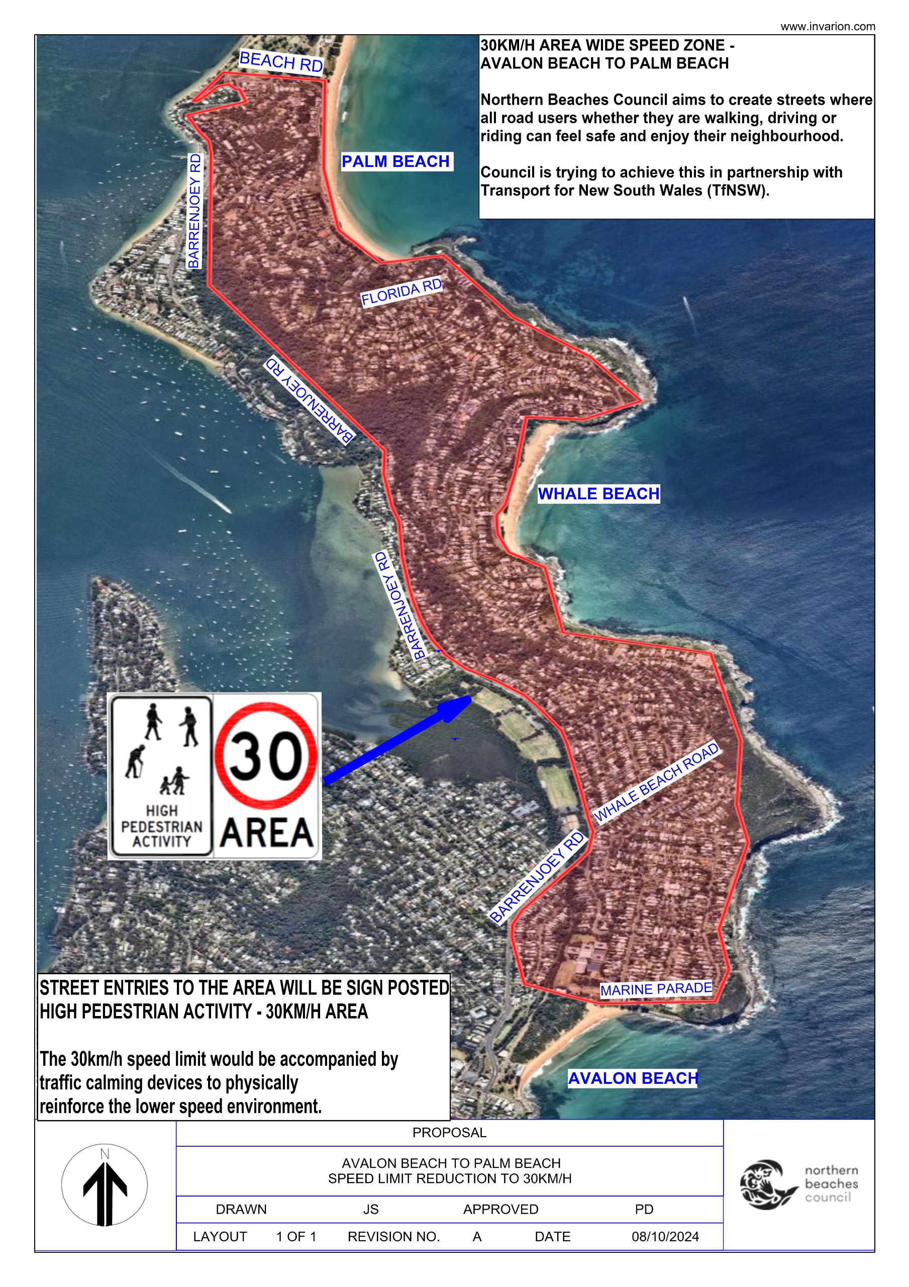
These works form part of a range of safety and road improvements consultations the council has undertaken in recent months. Proposals for North Narrabeen to Mona Vale and Avalon to Palm Beach Safety Zones ran from early October to late November 2024.
Council's 2023/2024 Annual Report states the NSW Department of Transport provided $3,490,000 from the Safe Speed Program 2023-2024 to support the council in introducing safe speeds in high pedestrian activity and local areas.
The Safe Speed Program is a program by the New South Wales (NSW) Government to improve road safety via:
- Speed zones - NSW reviews speed zones based on factors such as crash history, road use, and the presence of vulnerable road users.
- Speed Adviser app - This app uses GPS and map data to monitor a vehicle's speed and provide alerts when the speed limit is exceeded.
- Road Safety Program - This program aims to reduce severe injuries and fatalities on NSW roads, with a focus on vulnerable road users.
- Speed cameras - Fixed digital speed cameras use electronic sensors embedded in the road to measure vehicle speed. If a vehicle exceeds the speed limit, the camera takes a digital image of the vehicle.
- Reduced speed limits - Speed limits can be reduced on selected roads to improve safety.
Under the NSW Safer Roads map, Transport for NSW's interactive map shows projects it states will improve safety on urban and rural roads across NSW as part of the NSW Towards Zero Safer Roads Program and the Federal Road Safety Program.
Listed for Pittwater, and the LGA, under the Road Safety Program (federal) on the interactive map and allocated by the NSW Government in NSW Road Safety Program - Round 2 Approved Projects 2023 to 2026 (PDF, 258.34 KB) are:
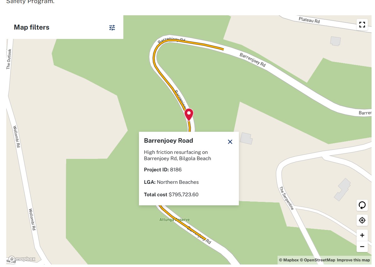
- Barrenjoey Road - High friction resurfacing on Barrenjoey Rd, Bilgola Beach. Project ID: 8186. LGA: Northern Beaches. Total cost: $795,723.60 2023-25-NSW-077 Urban High friction resurfacing of a portion of Barrenjoey Road Bilgola Beach - Northern Beaches Surface Treatments Total Cost: $795,724
- 2023-25-NSW-075 Footpaths/Cycleway Upgrade of existing unsignalised pedestrian (zebra) crossing to signalised pedestrian crossing at Forest Way and Warringah Road, Frenchs Forest - Northern Beaches Pedestrian/Cyclist treatments Total cost: $455,204
- 2023-25-NSW-086 Footpaths/Cycleway Forest Way Belrose - Between Wearden Road and Glen Street - Pedestrian Fencing - Northern Beaches Pedestrian/Cyclist treatments Total cost: $307,237
The Round 3 2023 to 2026 – Local Government project allocations lists:
- 2023-25-NSW-198 Footpaths/Cycleway South Creek Road, Cromer - Pedestrian Crossing Upgrade - accessibility project - Cromer High School - Northern Beaches Pedestrian/Cyclist treatments Total cost: $266,457
- 2023-25-NSW-242 Footpaths/Cycleway Oliver Way South of Emma Street, Mona Vale – Upgrade of existing pedestrian refuge to Raised Pedestrian Crossing and upgrading intersection of Jeanette Avenue at Maxwell Street from give-way to stop - Northern Beaches Pedestrian/Cyclist treatments. Total cost: $243,198
- 2023-25-NSW-243 Footpaths/Cycleway Melwood Avenue, Killarney Heights – Upgrade existing children crossing to raised pedestrian crossing and centreline making Northern Beaches Pedestrian/Cyclist treatments. Total cost: $246,198
- 2023-25-NSW-244 Footpaths/Cycleway Quirk Road south of Innes Road, Manly Vale – Installation of raised pedestrian crossing and upgrading intersection of Gordon Street from Quirk Road from give-way to stop Northern Beaches Pedestrian/Cyclist treatments. Total cost: $237,574
- 2023-25-NSW-251 Footpaths/Cycleway Carawa Road, Cromer - New Footpath, pedestrian fencing on kerb and Raised Pedestrian Crossings Northern Beaches Pedestrian/Cyclist treatments. Total cost: $1,284,304
- 2023-25-NSW-263 Footpaths/Cycleway Park Street west of Pittwater Road, Mona Vale - Upgrade existing marked pedestrian crossing to a raised pedestrian crossing - Northern Beaches Pedestrian/Cyclist treatments. Total cost: $245,258
- 2023-25-NSW-267 Footpaths/Cycleway Headland Road west of Harbord Road, North Curl Curl - New Raised Shared-User Crossing and pedestrian fencing on kerb - Northern Beaches Pedestrian/Cyclist treatments. Total cost: $502,863
Under the NSW Road Safety Program - Round 1 Approved Projects (PDF, 158.73 KB): nothing is listed for the NBC LGA.
Although this project is shown on the interactive map it is not listed in any of the Transport for NSW lists of NSW Road Safety Program - Round 1 Approved Projects, NSW Road Safety Program - Round 2 Approved Projects or the NSW Road Safety Program - Round 3 Local Government approved projects documents.
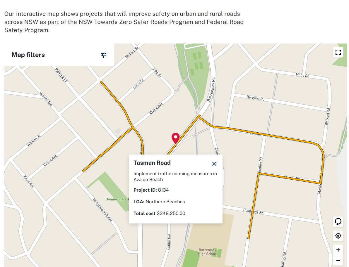
Tasman Road - Implement traffic calming measures in Avalon Beach. Project ID: 8134. LGA: Northern Beaches. Total cost: $348,250.00
Other local projects listed on the Transport for NSW interactive map, under Transport for NSW's Towards Zero Safer Roads Program, include:
- Condamine Street - Project development corridor study. Project ID: 7859. LGA: Northern Beaches. Total cost: $250,000.00
- Pittwater Road - Intersection safety improvements at Pittwater Road and Delmar Parade, Dee Why. Project ID: 8835. LGA: Northern Beaches. Total cost: $191,912.00
- Pittwater Road - Development of pedestrian safety improvements at Pittwater Road North Manly. Project ID: 8864. LGA: Northern Beaches. Total cost: $360,000.00
- Forest Way - Upgrade pedestrian crossing at Forest Way and Warringah Rd, Frenchs Forest. Project ID: 8008. LGA: Northern Beaches. Total cost: $455,204.45
- Forest Way - Pedestrian Fencing on Forest Way, Belrose. Project ID: 8446. LGA: Northern Beaches. Total cost: $307,237.15
Background
The Australian Government committed $2.96 billion to the Road Safety Program over 6 years from 1 January 2021. This Program supports the rollout of lifesaving road safety treatments that will contribute to a reduction in death and serious injury road crashes, and provide greater protections for vulnerable road users such as cyclists and pedestrians.
Treatments include shoulder widening and sealing, line markings, the installation of safety barriers and guardrails, intersection upgrades, roundabouts, truck bays, and pedestrian and cycleway improvements.
The Program was redesigned and new guidelines were issued on 23 August 2023 to better align with the National Road Safety Strategy 2021-30 and the National Road Safety Action Plan 2023-25 , that set the visions, targets and priorities for road safety in Australia.
The redesigned Program had a total funding pool of $965 million over three years from 2023-24, to 2025-26.The Program is scheduled to terminate on 30 June 2026.
All project contributions will be as per clause 15a of the Federation Funding Agreement Agreement on Land Transport Infrastructure Projects (Infrastructure FFA).
As stated above, the Northern Beaches Council, under the Local Roads and Community Infrastructure (LRCI) Program, has been allocated $13,808,306.
Phases 1, 2 and 3
From July 2020, an initial $500 million was made available to funding recipients to deliver Phase 1 of the LRCI Program. In December 2020, the LRCI Program was expanded to Phase 2 with an additional $1 billion in funding. A $1 billion Phase 3 of the LRCI Program was introduced in October 2020. The Government recently extended the timeframe for construction of projects funded under Phases 1, 2 and 3 to 30 June 2024.
Phase 4
From July 2023, LRCI Program funding recipients were allocated $750 million in Phase 4 funding. Phase 4 funding allocations include an additional $250 million targeted to improve rural, regional and outer urban roads. Projects funded under Phase 4 are expected to be completed by 30 June 2025.
NBC allocations:
- Phase 1: $1,418,332
- Phase 2: $8,134,978
- Phase 3: $2,836,664
- Phase 4: $1,418,332
- Total allocation: $13,808,306
Councils have until 31 December 2024 to submit final reports for payment of their remaining funding allocations under Phases 1, 2 and 3 of the Local Roads and Community Infrastructure (LRCI) Program.
Unless councils have already been granted an extension to their grant agreement and work schedule, construction activity on eligible projects under Phase 1, 2 or 3 should have been finalised by 30 June 2024 and annual reports submitted by 31 October 2024.
Projects funded under Phase 4 of the LRCI Program are required to be physically completed with all LRCI funding expended (using accrual accounting) by 30 June 2025. Final payments will be made in 2025-26 before the program closes on 30 June 2026.
The Safer Local Roads and Infrastructure Program (SLRIP) commenced on 1 July 2024 to provide funding for projects to address current and emerging priorities in road infrastructure needs.
The SLRIP has been created as part of the Australian Government’s commitment to strengthen investment to support the delivery of safer and more productive roads across Australia. Funding of at least $200 million per year will be available under the program.
The SLRIP is open for applications all year round. Tranche 2 is currently open and closes on 31 January 2025.
Transport for NSW's Road Safety Program 2023/24-2025/26 webpage (Reviewed 2 Dec 2024) provides:
Project overview
The Australian and NSW Governments are investing $518 million to improve safety and reduce crashes on NSW roads.
The Road Safety Program 2023/24-2025/26 was launched in early 2024. $103.6 million of funding was made available to councils across NSW.
The Program seeks to improve road safety by minimising the occurrence of severe injuries and fatalities, with a focus on vulnerable road users like pedestrians and cyclists. It targets both urban areas and rural high-speed roads, aiming to reduce off-road and head-on collisions.
Program objectives
The outcomes and objectives of the Program are to:
- Deliver lifesaving road safety treatments on remote, regional, and urban roads.
- Implement treatments that deliver improved Road Safety Outcomes linked to the National Road Safety Strategy 2021-30 and the National Road Safety Action Plan 2023-25, as well as the NSW Governments Road Safety Action Plan 2026. The goal of this program is to reduce fatal injuries by 50 per cent and serious injuries by 30 per cent on NSW roads by 2030.
- Improve risk ratings on roads to a minimum of ‘three-star’ rating on high-risk highways and arterial roads.
- Improved protection for vulnerable road users, particularly on urban footpaths, shared pathways, cycleways and road crossings.
This Program contains a main program and four sub-programs:
- School Zone Infrastructure Sub-Program
- Walking and Cycling Infrastructure Sub-Program
- Pedestrian Protection Sub-Program (State program)
- Safety Barrier Mass Action Program (State Program).
Funding Applications for Road Safety Program 2023/24-2025/26
Applications opened to NSW Councils on 4 March 2024 and closed at midnight on 10 May 2024.
Successful applicants were notified in November 2024.
Details on Pittwater consultations under the Safe Speed Program, called by council the 'Safer Neighbourhood Program' include:
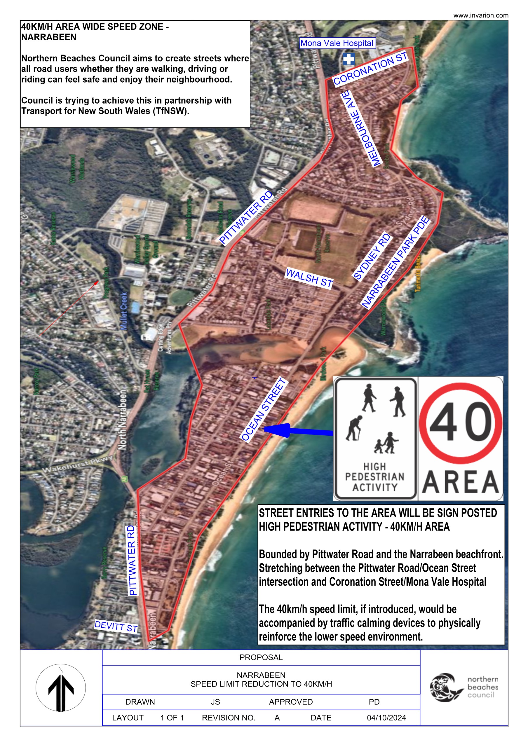
Safer Neighbourhoods Program: Narrabeen to Mona Vale
Avalon Beach to Palm Beach Safety Zone - have your say
Boondah Road, Warriewood - Upgrade: feedback sought
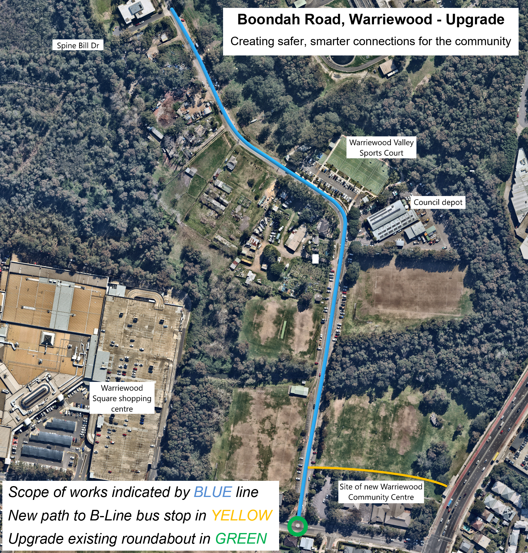
Council is proposing to undertake a significant upgrade of Boondah Road in Warriewood, between Spine Bill Drive to Jacksons Road.
The project is a key component of the Warriewood Valley Roads Masterplan, Landscape Masterplan, and Development Contributions Plan, designed to meet the evolving needs of the community.
Council states the upgrade will enhance access to sports fields, improve connections to the existing road and cycle network, and provide better access to public facilities, including the future Warriewood Community Centre.
Key changes include:- new 2.5m wide shared-user path for walking and cycling
- new dedicated footpath for pedestrian safety
- new raised pedestrian crossings for improved safety
- addition of designated parking bays
- road surface improvements
- new road markings and signage
- upgrades to existing lighting and new lighting over pedestrian crossings for enhanced safety
- emergency vehicle driveway access bays
- new landscaping
- new shared path connecting to B-line bus stop on Pittwater Road
- new roundabout installed at the Boondah Road and Jacksons Road intersection.
Council states the concept design is based on thorough research, including surveys and geotechnical field investigations.
In conjunction with the proposed Boondah Road upgrade, additional infrastructure improvements are planned for the surrounding area. These include the development of new hard court facilities with lighting and construction of a purpose-built sports amenities building.
Council will release details of those proposals next year to gather feedback on these designs.
Construction for the Boondah works anticipated to commence in mid-2025, pending outcomes of community feedback and subject to decision of the Local Traffic Committee. Works anticipated to take 6 months to complete, weather dependent.
Have a look, have a say, here - comments close December 12 2024:
Scope of work Illustration courtesy NBC:
- new 2.5m wide shared-user path for walking and cycling
- new dedicated footpath for pedestrian safety
- new raised pedestrian crossings for improved safety
- addition of designated parking bays
- road surface improvements
- new road markings and signage
- upgrades to existing lighting and new lighting over pedestrian crossings for enhanced safety
- emergency vehicle driveway access bays
- new landscaping
- new shared path connecting to B-line bus stop on Pittwater Road
- new roundabout installed at the Boondah Road and Jacksons Road intersection.
