State of the beaches 2023-24 Report + Beachwatch Program NSW Government Changes update + Narrabeen lagoon entrance openings not recorded + the 'state of Collaroy-Narrabeen beach' - Extension approved
Recreational water quality has been monitored in the Sydney region since 1989 by the Department of Climate Change, Energy, the Environment and Water’s Beachwatch program and since 2022 by Blue Mountains City Council under the Beachwatch Partnership Program.
Monitoring of estuarine beaches commenced in 1994, with the addition of Sydney Harbour, Botany Bay and lower Georges River to the program. Pittwater Council estuarine areas were added in 1996 and most sites in Port Hacking were added in 1999.
In December 2023 the NSW Department of Climate Change, Energy, the Environment and Water (DCCEEW) unexpectedly advised that NSW councils who wish to continue participating in the Beachwatch program will be required to provide funding for it from 1 July 2024.
In order to continue to participate in the program, Council will need to a) sign on to the program as a “partner”, and b) nominate whether it will provide its own collection and analysis of water quality samples, or engage the NSW Government to undertake some or all of this work.
Many regional councils have been funding their own sampling and analysis for many years, however unlike Sydney councils, they typically operate their own water and sewer services and undertake testing to ensure the services they provide are not impacting on downstream waters.
At the March 2024 NBC Council Meeting it was stated in the Executive Summary of this proposal;
''It is considered that Council has no obligation to provide this service, and given the lack of engagement and the significant and imminent financial impact of this cost-shifting exercise, it is proposed that Council not sign up to the program.''
Council is required to advise DCCEEW of its decision by 30 April 2024.''
On March 5, 2024 the Sydney Coastal Councils Group (SCCG), representing nine coastal and estuarine councils in Sydney, relaeased a statement to the effect that Sydney coastal councils reject NSW Government’s attempts to shift costs for NSW Beachwatch to local government.
'The NSW Government is attempting to shift the costs of its successful and long-running NSW Beachwatch program to coastal councils in Sydney. The NSW Beachwatch program helps people make informed decisions about when and where to swim. ' the statement reads
Sydney Coastal Councils Group (SCCG), representing nine coastal and estuarine councils in Sydney, supports the program’s value to not only local residents but to the broader NSW community and international tourists that visit our world-renowned beaches. However, it rejects the NSW Government’s attempts to shift the cost of the program to local councils for what is a state government responsibility.
Generally, Councils have no control over the land or waterways below mean high water where Beachwatch monitoring is conducted. Councils also have no control over sewers which is the primary source of bacteriological contamination of waterways that impact on swimming.
Costs for the service provided by the NSW Government to coastal councils represent a significant financial impost on councils that are already grappling with increasing community expectations, constrained budgets and other forms of state government cost-shifting.
In light of this, the SCCG calls on the NSW Government to maintain the NSW Beachwatch program as a fully-funded state program without shifting costs to Sydney coastal councils.
SCCG also calls on the Minister for the Environment, in consultation with the Minister for Water, to request Sydney Water, as the provider of sewerage services in Sydney, to take a role in water quality monitoring at Beachwatch sites.
Cr. Miranda Korzy, in her 'From the Council Chamber March 2024' updates, reported;
'One example of state government cost shifting is the NSW government’s attempt to convince the council to pick up the tab for Beachwatch, which was unanimously rejected at the March meeting.
The NSW Beachwatch program has operated across Sydney’s beaches, including 39 sites on the Northern Beaches, since 1989, monitoring water quality and informing the public about the results. However, last December, the department responsible (NSW Department of Climate Change, Energy, the Environment and Water known as DCCEEW), unexpectedly announced it would no longer cover the cost of the program and Sydney councils would have to pay if they want to continue with it.
The government offered NBC two options: either council collects water samples and sends them to DCCEEW for analysis at a cost of $198,800; or council engages DCCEEW to continue collecting and analysing samples at $129,383.
Background to the council report noted that regional councils have funded their own sampling and analysis for many years, however they are also typically providers of water and sewer services - unlike NBC and other Sydney coastal councils.
However, the Northern Beaches is not alone with this offer and a group known as the Sydney Coastal Councils Group (SCCG), to which NBC belongs, is leading opposition to this latest attempt at cost shifting to councils. As the NBC councillor rep on the SCCG executive committee, I outlined at the March meeting the work the group has already carried out on this issue.
After being advised about the government’s decision in December, the SCCG obtained legal advice that indicates Councils do not have responsibility for water quality below the mean high water mark. It then informed councils, also pointing out that Sydney Water, which is a major polluter, had not been asked to contribute to the cost of Beachwatch. Then at its March Executive meeting, it approved letters to the Environment and Water ministers opposing the new payment scheme.
As a result, Council staff recommended that we express our support for continuation of the Beachwatch program but object to the payment scheme and support the SCCG in its advocacy on the issue.
Pittwater Liberal councillor Karina Page successfully moved at Tuesday’s meeting that we strengthen the language to “strenuously object”, while Narrabeen Independent councillor Vince De Luca called for the council to also write to the Climate Change, Energy, Environment and Water Minister Penny Sharpe, along with her Opposition counterpart and crossbench party leaders.
Some residents had expressed concern to me that without the council participating in the Beachwatch scheme, we would be left without current information about water quality at local beaches. However, I asked at the meeting if our historical Beachwatch data could be used to inform residents and visitors about likely water quality under any given conditions, and staff agreed it could be.
Furthermore, I argued we simply don’t have any spare money to pay nearly $200,000 towards the analysis. So I told council I thought we should stand with the SCCG and other coastal councils to send a clear message to the state government. I was pleased that all councillors agreed to this approach.'
On May 4 2024 the NSW Government announced it ''is giving Sydney coastal councils an additional 12 months’ consultation before the implementation of the Universal Beachwatch Partnership Program which provides information on water quality at our beaches and waterways.''
Under a media release titled ''Beachwatch consultation reinstated'' the government stated:
'In July 2022, the former government decided to expand the cost sharing partnership model which has been in place across regional New South Wales since 2002, to include 14 Sydney coastal councils which currently do not pay for water quality sampling and laboratory analysis.
Under the current Beachwatch program, Sydney coastal councils do not share the costs with the NSW Government, but regional councils do. The proposed changes were designed to make the system equitable and manage growth of the Universal Beachwatch Partnership Program to more areas.
Consultation was supposed to start in late 2022 to give councils 18 months’ notice before the decision came into effect in July 2024. However, the consultation was deferred until December 2023. Sydney coastal councils have provided feedback on several issues regarding the proposed changes, including that 6 months' consultation is not sufficient for them to plan for and consider the transition.
The NSW Government has listened to this feedback from councils, and is reinstating the 18-month consultation period, which will now run through to June 2025.
This will allow for further consultation on changes to the funding model and design of the program.
Minister for the Environment Penny Sharpe is writing to the 14 affected coastal councils to inform them the proposed changes will not go ahead until mid-2025, following further work on the program design.
The 14 Sydney coastal councils are Bayside, Canada Bay, Georges River, Hunters Hill, Inner West, Lane Cove, Mosman, North Sydney, Northern Beaches, Randwick, Sutherland, Waverley, Willoughby and Woollahra.'
A Quote attributable to Minister for Climate Change and the Environment Penny Sharpe, was given as:
'Beachwatch is an important program for those who visit our beaches and waterways, and for councils that work with Beachwatch to detect and respond to emerging pollution problems.
'The NSW Government is committed to ensuring an equitable service and good program design for all councils across the state.
'We are dedicated to genuine partnerships with councils, and look forward to working with them to ensure Beachwatch can give the community confidence to swim in more waterways across New South Wales.'
Background information provided was:
Beachwatch provides daily advice on swim site suitability for people to choose if and when to swim.
In response to pollution from Sydney’s ocean-wastewater outfalls, in 1989, Beachwatch commenced providing water quality monitoring at no cost to Sydney coastal councils.
At present, Beachwatch monitors 97 swim sites within 14 local government areas in the Sydney coastal area at no cost.
Since 2002, regional councils and wastewater managers have participated in the Beachwatch Partnership Program. Currently there are 10 regional NSW councils and two wastewater managers (Hunter and Sydney Water Corporations) who have funded their own sampling and analysis across 128 swim sites.
The 2022–23 budget provided $18.5 million over 10 years to deliver the Universal Beachwatch Partnership Program statewide and support all NSW councils to be able to opt in from July 2024.
Under this model, the Universal Beachwatch Partnership Program will provide a centralised coordination, data management, technical support, quality control, audit, and reporting services, while local council partners provide water quality sampling and analysis for priority swim sites in their local government areas.
The 'State of the Beaches 2023-2024' report summarises the performance of 101 swimming sites in the Sydney region, providing a long-term assessment of how suitable a site is for swimming.
Monitored sites include ocean beaches, a lagoon, a rockpool, estuarine sites in Pittwater, Sydney Harbour, Botany Bay, lower Georges River and Port Hacking and freshwater creeks in the Blue Mountains.
The Report states that in 2023–2024, 67% of swimming sites in the Sydney region were graded as Good or Very Good, including 33 ocean beaches. The grades are determined from the most recent 100 water quality results (2–4 years’ worth of data depending on the sampling frequency) and a risk assessment of potential pollution source.
These sites were suitable for swimming for most or almost all of the time. This is a decline in overall performance from the previous year, and reflects the wet weather impacts, including significant rainfall and flooding in April.
Despite some Poor grades, the majority of monitored sites were still suitable for swimming during dry weather. The Sydney region has a large proportion of lagoon and estuarine swimming locations, which have been most susceptible to impacts from significant rain events.
The Report states that rainfall is the major driver of pollution to recreational waters, generating stormwater runoff and triggering untreated discharges from the wastewater treatment and transport systems. Changes in rainfall patterns are reflected in beach water quality over time due to variation in the frequency and extent of stormwater and wastewater inputs.
The Beach Suitability Grades for 2023–2024 are based on water quality data collected over the last 2–4 years.
Rainfall over this period has been diverse:
- 2020–2021: variable rainfall with some very wet months over summer and early autumn
- 2021–2022: varied rainfall, with extreme wet weather conditions over summer and early autumn, and significant flooding
- 2022–2023: varied rainfall, with some very wet months over winter and spring, including the wettest July on record
- 2023–2024: average to below average rainfall, and a wet April 2024, particularly in the north.
Rainfall in the Sydney region was generally average to below average for the 2023–2024 reporting year. While rainfall in winter and spring 2023 was well below the long-term average, rainfall in summer and early autumn returned to average conditions. Above average rainfall fell in April, but was wetter in northern Sydney than other areas.
Mona Vale recorded its highest April daily rainfall of 140.2 mm on 6 April, and highest April total rainfall in 34 years with more than double the long-term monthly average of 265.6 mm.
Significant rainfall in early April triggered localised flooding and made microbial water quality unsuitable for swimming at some sites. The most affected areas were in estuaries and lagoons, which have a lower level of flushing and took longer to recover from the stormwater inputs than the ocean beaches. The water quality at some ocean beaches located near open lagoons or rivers was also impacted by stormwater and floodwaters discharging from these sources.
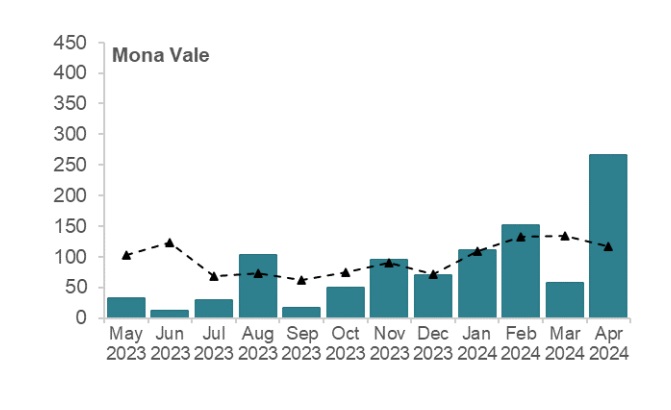
Sydney region rainfall: Mona Vale. Source: NSW State of the beaches 2023–2024 report
Barrenjoey to Manly Details: 2023-2024
Details for the Barrenjoey to Manly peninsula, in sequence from the north to the south, include:
Northern Sydney (Pittwater to Manly): Overall results
Twenty-eight of the 32 swimming sites were graded as Very Good or Good in 2023–2024. This is a very good result despite the slight decline in performance from the previous year.
Best beaches: All in Pittwater
Palm Beach, Whale Beach, Avalon Beach, Newport Beach, Bungan Beach, Mona Vale Beach and The Basin.
These sites had excellent water quality and were suitable for swimming almost all of the time.
Swimming sites monitored in the Northern Sydney region include ocean beaches, estuarine areas in Pittwater and lagoon sites in Narrabeen Lagoon, with each site type having a different response to rainfall-related impacts.
Estuarine and lagoon swimming sites did not perform as well as ocean beaches due to lower levels of flushing, which increase the time needed to disperse and dilute pollution inputs, taking longer to recover from stormwater events.
As a general precaution swimming should be avoided during and for at least one day after heavy rain at ocean beaches, and for up to 3 days in estuarine and lagoon areas, or if there are signs of stormwater pollution such as discoloured water or floating debris.
Swimming is not recommended at ocean beaches located near lagoon entrances if the lagoon is open, due to the possibility of pollution from the outflow.
Ocean beaches
The Report states 19 of the 20 ocean beaches were graded as Very Good or Good in 2023–2024. Palm Beach, Whale Beach, Avalon Beach, Newport Beach, Bungan Beach and Mona Vale Beach were graded as Very Good. The water quality at these sites was of a very high standard and suitable for swimming almost all of the time.
Newport Beach, Bungan Beach and Mona Vale Beach were upgraded to Very Good from Good, due to improved microbial water quality.
Bilgola Beach, Warriewood Beach, Turimetta Beach, North Narrabeen Beach, Collaroy Beach, Long Reef Beach, Dee Why Beach, North Curl Curl Beach, South Curl Curl Beach, Freshwater Beach, Queenscliff Beach, North Steyne Beach and South Steyne Beach were graded as Good in 2023–2024. Water quality was frequently suitable for swimming during dry weather conditions, with elevated levels of enterococci recorded following rainfall.
Shelly Beach was downgraded to Poor in 2023–2024, due to a decline in microbial water quality. Water quality at this site has shown trends of declining microbial assessments over the last 6 years, and has crossed the threshold from Good to Poor. Despite this, 88% of samples collected during dry weather conditions were within the safe swimming limit.
It is recommended that swimming be avoided at ocean beaches during and for up to one day following rainfall, or if there are signs of pollution such as discoloured water, flowing drains or floating debris.
Estuarine beaches
Nine of the 10 estuarine swimming sites in Pittwater were graded as Very Good or Good in 2023–2024.
The Basin was graded as Very Good. This site had excellent water quality and was suitable for swimming almost all of the time.
Barrenjoey Beach, Paradise Beach Baths, Clareville Beach, Taylors Point Baths, North Scotland Island, South Scotland Island, Elvina Bay and Great Mackerel Beach were graded as Good in 2023–2024. Great Mackerel Beach was downgraded to Good from Very Good in the previous year due to declined microbial water quality.
Water quality at these sites was suitable for swimming most of the time, with elevated levels of enterococci mostly recorded following rainfall. Bacterial levels were occasionally elevated at Barrenjoey Beach during dry weather conditions.
Bayview Baths was graded as Poor, a consistent result with previous years. Elevated enterococci levels were occasionally recorded during dry weather conditions, and regularly after moderate to heavy rainfall. Water quality at this site can take longer to recover from stormwater events than at other Pittwater swimming sites due to lower levels of flushing.
Lake/lagoon swimming sites
The 2 swimming sites in Narrabeen Lagoon, Birdwood Park and Bilarong Reserve, continued to be graded as Poor in 2023–2024, as in previous years. Water quality at Birdwood Park and Bilarong Reserve was often suitable for swimming during dry weather, with 76% and 58% of dry weather samples within the safe swimming limit, respectively. However, enterococci levels increased with increasing rainfall, often exceeding the safe swimming limit after little or no rainfall, and frequently after moderate to heavy rainfall.
Birdwood Park is located at the entrance to the lagoon and water quality at this site is influenced by wet weather events and whether the lagoon is open to the ocean. Discharge from Narrabeen Lagoon is a significant source of faecal contamination.
Bilarong Reserve in Narrabeen Lagoon retains pollution inputs because it is located away from the lagoon entrance and is not well flushed by clean ocean water. A significant source of faecal contamination is stormwater runoff to the lagoon.
The 2023-2024 State of the Beaches report states:
The amount of time the lagoon is open or closed influences water quality at Birdwood Park and Bilarong Reserve lagoon sites. During periods of entrance closure, water quality is likely to decline as pollution inputs are not as readily dissipated or flushed. The lagoon entrance will open and close naturally depending on how much rainfall has occurred and how much sand has accumulated in the mouth. When there are very large accumulations of sand, the entrance will often close and stay closed until the sand is removed by Northern Beaches Council.
Historically this process happens every 4–5 years, with the last sand clearance operation being completed in December 2021. With the adoption of the Narrabeen Lagoon Entrance Management Strategy in September 2022, council will be trialling more frequent but smaller sand clearance operations (every 2–3 years rather than 4–5 years).
However, sand clearance works at Narrabeen Lagoon entrance have been occurring far more often than what has been recorded in the 2023-24 report.
Council announced on Tuesday, 12 September 2023 work to clear Narrabeen Lagoon entrance to reduce the risk of flooding to local homes and businesses. These works were completed by November 30 2023.
''Council contractors will excavate more than 20,000 cubic metres (40,000 tonnes) of sand – equivalent to the weight of 100 jumbo jets – to the east and west of Ocean Street Bridge.'' it was stated
The sand was to be deposited at Collaroy-Narrabeen Beach between Goodwin and Stuart Streets. The project was partly grant funded under the NSW Government Floodplain Management Program, and costed $1.5 million.
Soon after the entrance was blocked again and the Council contracted more sand being removed in February 2024. This means the lagoon entrance was open for around 6.5 weeks prior to the big seas which moved sand on the tail end of Cyclone Kirrily as it moved south.
Council announced on Friday October 9 2021 they were getting works done to open the entrance of Narrabeen to let the water flow as ''there is rain forecast for every day this coming week''.
In July 2016, weeks after the councils had been forcibly amalgamated and in response to the June 2016 storm, the NSW Coalition government installed administrator Dick Persson outlined a Draft Coastal Erosion Policy for Collaroy that resulted in the December 2016 Coastal Zone Management Plan for Collaroy-Narrabeen Beach and Fishermans Beach being formalised under the same administration.
That Administrators Minute stated:
I am advised that the initial estimates for 1.1km of works from The Marquesas to 1096 Pittwater Road has been estimated at approximately $22 million. While Council will work with the State Government to meet the cost of directly protecting public assets in this area (approximately $5.5 million), I will also ask the State Government to join Council in providing up to 10% each towards the cost of private protection as a contribution subject to a positive cost benefit analysis for these public assets. Early estimates suggest this contribution could be approximately. This contribution has been estimated at approximately $3.3 million ($1.65 million from State and $1.65 million from Council) and is in recognition of the public asset protection that is provided by these private properties.
Those opposed to installation of the wall state the 'public asset' was the beach itself, part of which was taken to facilitate the works, the wall contravenes the NSW Coastal Act and the Coastal SEPP, and that the cement revetment wall, now installed, and to be extended northward, would ruin the beach.
Surfers who have caught waves from banks off the section for decades have stated these no longer exist and the wave/s are gone.
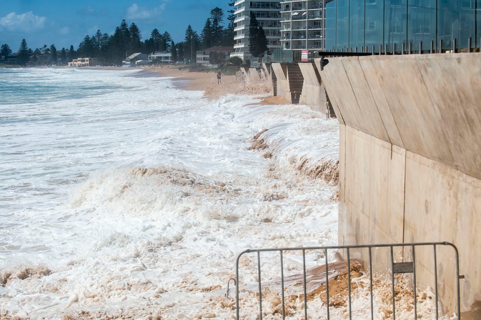
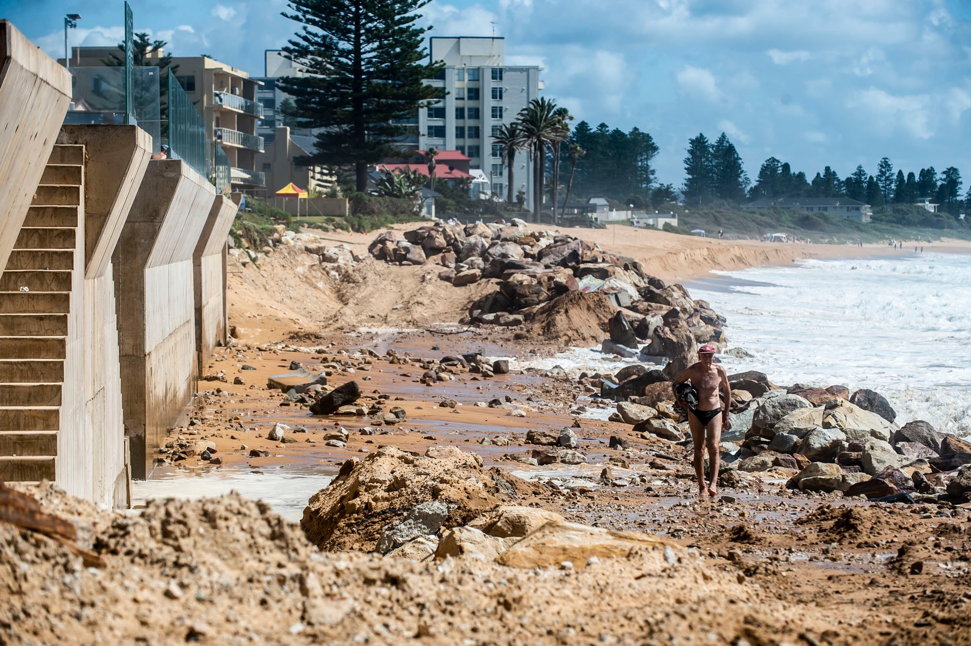
In September 2023 Northern Beaches Council's Northern Beaches Planning Panel (NBPP) approved an extension of this wall to protect properties at 1 Clarke Street Narrabeen & 1192 Pittwater Road Narrabeen & 1194 Pittwater Road Narrabeen & 1196 Pittwater Road Narrabeen & 1204 Pittwater Road Narrabeen.
The DA (DA2021/1612) costs the works at $ 2,047,433.
The NBPP stated in its report on the DA these works are permitted with consent under Clause 2.16 of the State Environmental Planning Policy (Resilience and Hazards) 2021. As per section 2.19 and Schedule 6 Clause 8A (1)(a) of the State Environmental Planning Policy (Planning Systems) 2021, Council is the consent authority as there is a certified Coastal Zone Management Plan in place for this beach (the Coastal Zone Management Plan for Collaroy-Narrabeen Beach and Fishermans Beach 2016).
The report also stated the works will link with Council's proposed coastal protection works at Clarke Street, South Narrabeen SLSC and Mactier Street.
Prior to the commencement of the previous works, on Friday, August 6th 2021 the council published ‘’Council Provides Facts On The Collaroy Residents’ Seawall’’ where Item 4 stated; 'The current works are entirely on private land'
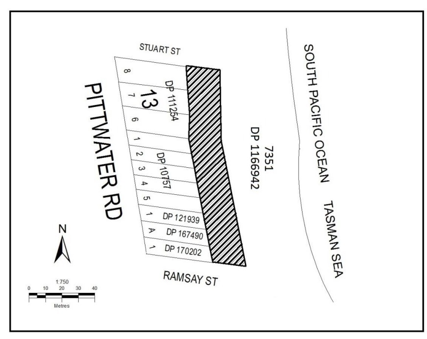
However, a February 2019 document and Notice by the NSW Department of Planning, Industry and Environment, ‘Notice of compulsory acquisition of land in the local government area of Narrabeen’ states;
‘The area of land 20m wide bound to the east by a line parallel to the eastern boundaries of Lots 6 to 8 Section 13 DP 111254, Lots 1 to 5 DP 10757, Lot 1 DP 121939, Lot A DP 167490 and Lot 1 DP 170202 and bound to the north by the prolongation of the northern boundary of Lot 8 Section 13 DP 111254 to the east and bound to the south by the prolongation of the southern boundary of Lot 1 DP 170202 to the east as indicated by hatching on the diagram below.’
The corresponding webpage states;
‘’ The DA is for a sloping rock revetment seawall, around 210 metres in length and 15 metres wide. The proposed structure, if approved, would encroach on Crown land by around 15 metres from property boundaries…’’
And;
‘’ The department has granted landowner’s consent for the DA to be assessed by Northern Beaches Council, which is required under Environmental Planning Assessment Regulations 2000. Landowner’s consent is not development approval. It is only the first step in the planning assessment. Should the DA be approved by Northern Beaches Council, the department will then begin negotiations on an appropriate tenure for the occupation of Crown land.’’
The compulsory acquisition of land was approved on February 20th, 2019. The approval included a diagram of the land compulsorily acquired:
The Guardian Australia published a photo on October 24th, 2021 by Lewis Isaacs that shows how far east from the boundaries of the owners' private land this wall has been built. That report is called 'A 7m wall has gone up on a Sydney beach: are we destroying public space to save private property?'
The works approved for the northwards sections of a wall are: 49.75m long (from north to south) along No. 1 Clarke Street and Nos. 1192, 1194 and 1196 Pittwater Road and 29.85m long (north to south) along 1204 Pittwater Road, Maximum of 7.0m AHD in height to the top of the wall and 8.0m to the top of the balustrade, 350mm in width (with 500mm wave return projection cantilevered over sand), plus stair over a 1.5m width at two locations. Permanent rock anchors will be sunk every 1.5m (behind the wall and buried).
The Determination, made on September 25 2023, lapses 2 years from the operation date of Consent.
The Commencement was Deferred as it is required a Demonstration of agreement between multiple properties be lodged.
The owners of the are to provide evidence to Council of an enforceable agreement that all owners will fund and construct the coastal protection works as a single project to be completed within 24 months of the on-site commencement of the construction works, or a longer period as agreed to by Council in writing.
Residents have continued to state they are shocked to see the degree to which the council have supported a development that clearly privatises profits (to protect private properties) and socialises the costs (in terms of loss of beach amenity and negative visual impacts).
Those property owners for the extended works have expressed relief they will go ahead.
The local boardriders clubs have stated, ''The vertical seawall is making the erosion worse on other parts of the beach. Sand flow has changed along the beach which is attributable to the seawall. The existing seawall is impacting the North Narrabeen Surf break, additional walls will magnify the problem.''
Which may signal the end of any decent waves for local, national and international surfing competitions held at North Narrabeen, and the end of those competitions, and the visitors they bring to the area.
In other 'state of our beaches' news - the report for 2023-2024 records;
State of the Beaches: Beach by Beach- Barrenjoey to Manly
Palm Beach
The Sate of the Beaches 20234-24 report records Palm Beach has a Suitability Grade of Very Good, which indicates microbial water quality is considered suitable for swimming almost all of the time, with few potential sources of faecal contamination. Enterococci levels increased slightly with increasing rainfall, occasionally exceeding the safe swimming limit after 10 mm or more of rain, and often after 20 mm or more. The site has been monitored since 1989.
Palm Beach stormwater drain opposite Wilshire Park creek, July 6, 2024
Whale Beach
Whale Beach has a Suitability Grade of Very Good, Beach Suitability Grade of Very Good, which indicates microbial water quality is considered suitable for swimming almost all of the time, with few potential sources of faecal contamination. Enterococci levels increased slightly with increasing rainfall, occasionally exceeding the safe swimming limit after 10 mm or more of rain. The site has been monitored since 1989.
Avalon Beach
Avalon Beach has a Beach Suitability Grade of Very Good, which indicates microbial water quality is considered suitable for swimming almost all of the time, with few potential sources of faecal contamination. Enterococci levels increased slightly with increasing rainfall, occasionally exceeding the safe swimming limit in response to 20 mm or more of rain. The site has been monitored since 1989.
Bilgola Beach
Bilgola Beach has a Beach Suitability Grade of Good, which indicates microbial water quality is considered suitable for swimming most of the time but can be susceptible to pollution after rain, with several potential sources of minor faecal contamination. Enterococci levels generally increased with increasing rainfall, occasionally exceeding the safe swimming limit after rain. The site has been monitored since 1989.
Newport Beach
Newport Beach has a Beach Suitability Grade of Very Good, which indicates microbial water quality is considered suitable for swimming almost all of the time, with few potential sources of faecal contamination. Enterococci levels generally increased with increasing rainfall, occasionally exceeding the safe swimming limit after rain. The site has been monitored since 1989.
Bungan Beach
Bungan Beach has a Beach Suitability Grade of Very Good, which indicates microbial water quality is considered suitable for swimming almost all of the time, with few potential sources of faecal contamination. Enterococci levels generally increased with increasing rainfall, occasionally exceeding the safe swimming limit in response to light rain. The site has been monitored since 1989.
Mona Vale Beach
Mona Vale Beach has a Beach Suitability Grade of Very Good, a return to this status after the decline in the 2022-23 results for this beach. This indicates microbial water quality is considered suitable for swimming almost all of the time, with few potential sources of faecal contamination. Enterococci levels generally increased with increasing rainfall, occasionally exceeding the safe swimming limit after light rain, and often after 20 mm or more.
Warriewood Beach
Warriewood Beach has a Beach Suitability Grade of Good, which indicates microbial water quality is considered suitable for swimming most of the time but can be susceptible to pollution after rain, with several potential sources of faecal contamination including Warriewood Wastewater Treatment Plant (WWTP).
Enterococci levels generally increased with increasing rainfall, occasionally exceeding the safe swimming limit after 5 mm or more of rain, and regularly after 20 mm or more. The sanitary inspection was recorded as 'Moderate' with the WWTP being attributed as the highest cause of contaminants. This status is unchanged from last year.
Turimetta Beach
Likewise Turimetta Beach has a Beach Suitability Grade of Good in 2023-24 which indicates microbial water quality is considered suitable for swimming most of the time but may be susceptible to pollution after rain, with several potential sources of faecal contamination including Warriewood WWTP.
Enterococci levels increased slightly with increasing rainfall, occasionally exceeding the safe swimming limit after light rain, and regularly after 20 mm or more.
The site has been monitored since 1994.
Once again the primary source of contaminates was the Warriewood Wastewater Treatment Plant (WWTP).
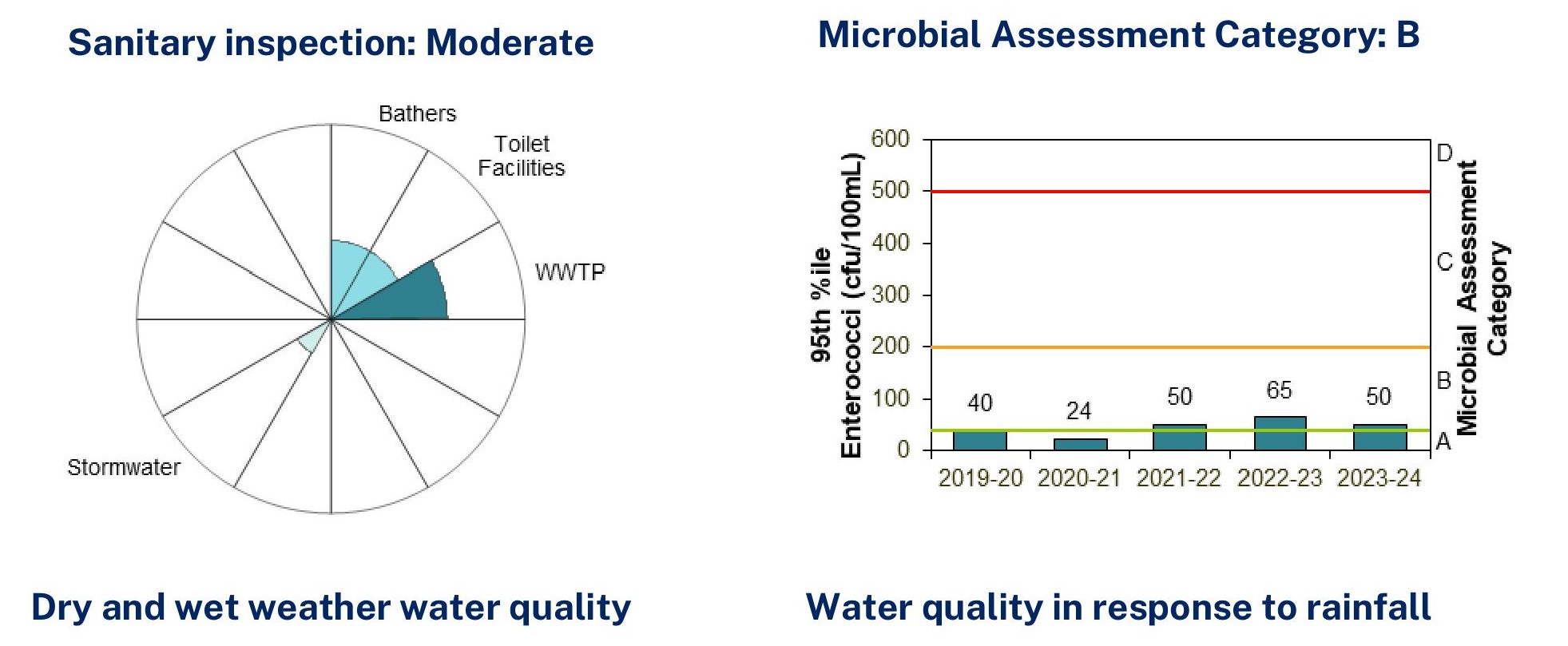
Warriewood Beach, Source: State of the Beaches report 2023-24
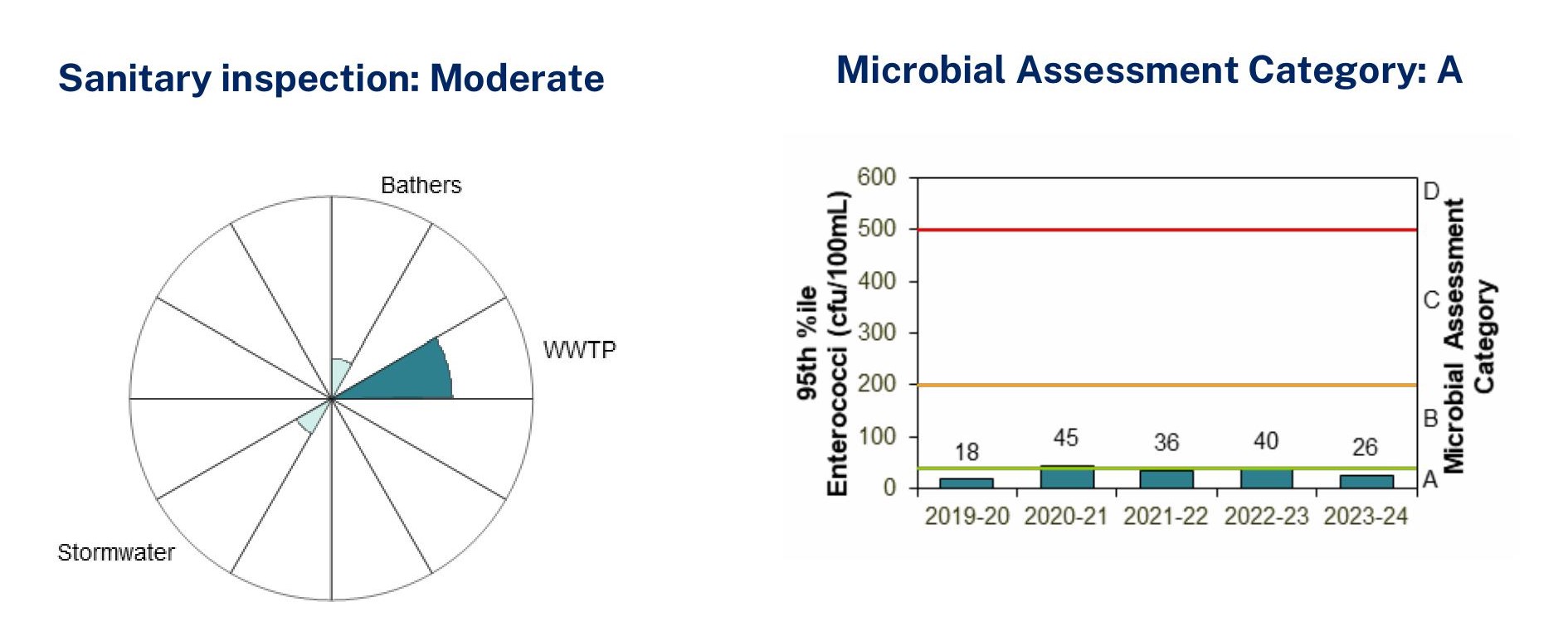
Turimetta Beach, Source: State of the Beaches report 2023-24
North Narrabeen Beach
North Narrabeen Beach has a Beach Suitability Grade of Good, which indicates microbial water quality is considered suitable for swimming most of the time but may be susceptible to pollution after rain, with several potential sources of faecal contamination, including discharge from Narrabeen Lagoon.
Enterococci levels generally increased with increasing rainfall, occasionally exceeding the safe swimming limit after light rain, and regularly after 20 mm or more.
The site has been monitored since 1989.
Narrabeen Lagoon (Birdwood Park)
Narrabeen Lagoon (Birdwood Park) has again received a Beach Suitability Grade of Poor, which indicates microbial water quality is susceptible to faecal pollution, particularly after rainfall and occasionally during dry weather conditions, with several potential sources of faecal contamination including from elsewhere within the lagoon.
Enterococci levels increased with increasing rainfall, occasionally exceeding the safe swimming limit after no rain, and often after rain. The site has been monitored since 2004.
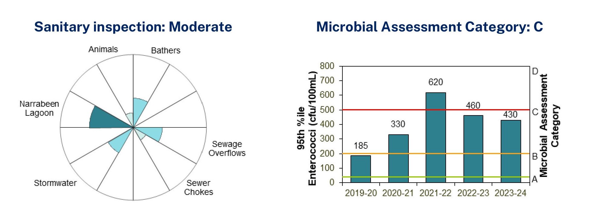
Birdwood Park, Source: State of the Beaches report 2023-24
Bilarong Reserve
Likewise Bilarong Reserve is again rated as a Beach Suitability Grade of Poor, which indicates microbial water quality is susceptible to faecal pollution, particularly after rainfall and occasionally during dry weather conditions, with several potential sources of faecal contamination including from elsewhere within the lagoon.
Enterococci levels increased with increasing rainfall, often exceeding the safe swimming limit in response to little or no rain, and regularly after 5 mm or more of rain.
However, the 2023-2024 period shows this has almost doubled - the report showing 620 in the previous year and 1050 for this reported year.
The site has been monitored since 2014.
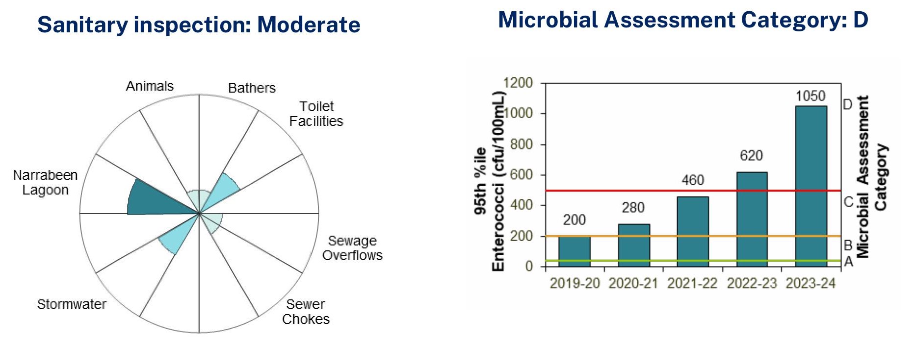
Bilarong Reserve, Source: State of the Beaches report 2023-24
Collaroy Beach
Collaroy Beach has been given a Beach Suitability Grade of Good indicates microbial water quality is considered suitable for swimming most of the time but may be susceptible to pollution after rain, with several potential sources of faecal contamination including stormwater.
Enterococci levels increased with increasing rainfall, occasionally exceeding the safe swimming limit after light rain, and often after 10 mm or more of rain.
The site has been monitored since 1989.
Long Reef Beach
Long Reef Beach has a Beach Suitability Grade of Good again in this report, which indicates microbial water quality is considered suitable for swimming most of the time but may be susceptible to pollution after rain, with potential faecal contamination from discharge from Dee Why Lagoon.
Enterococci levels generally increased with increasing rainfall, occasionally exceeding the safe swimming limit after 5 mm or more of rain, and regularly after 20 mm or more.
The site has been monitored since 1989.
Dee Why Beach
Dee Why Beach was given a Beach Suitability Grade of Good. This indicates microbial water quality is considered suitable for swimming most of the time but can be susceptible to pollution after rain, with several potential sources of faecal contamination.
Enterococci levels generally increased with increasing rainfall, often exceeding the safe swimming limit in response to 10 mm or more of rain, and regularly after 20 mm or more.
The site has been monitored since 1989.
North Curl Curl Beach
North Curl Curl Beach is again rated as having a Beach Suitability Grade of Good, which indicates microbial water quality is considered suitable for swimming most of the time but may be susceptible to pollution after rain, with several potential sources of faecal contamination including discharge from Curl Curl Lagoon.
Enterococci levels generally increased with increasing rainfall, occasionally exceeding the safe swimming limit after 5 mm or more of rain, and frequently after 20 mm or more.
The site has been monitored since 1989.
South Curl Curl Beach
South Curl Curl Beach has again been rated as having a Beach Suitability Grade of Good, which indicates microbial water quality is considered suitable for swimming most of the time but can be susceptible to pollution after rain, with several potential sources of faecal contamination.
Enterococci levels generally increased with increasing rainfall, occasionally exceeding the safe swimming limit in response to 5 mm or more of rain, and regularly after 20 mm or more.
The site has been monitored since 1989.
Freshwater Beach
Likewise Freshwater Beach has again received a Beach Suitability Grade of Good. This indicates microbial water quality is considered suitable for swimming most of the time but may be susceptible to pollution after rain, with several potential sources of faecal contamination including stormwater.
Enterococci levels generally increased with increasing rainfall, occasionally exceeding the safe swimming limit after light rain, and regularly after 20 mm or more.
The site has been monitored since 1989.
Queenscliff Beach
Queenscliff Beach is again rated a Beach Suitability Grade of Good, which indicates microbial water quality is considered suitable for swimming most of the time but may be susceptible to pollution after rain, with several potential sources of faecal contamination, including discharge from Manly Lagoon.
Enterococci levels increased with increasing rainfall, occasionally exceeding the safe swimming limit after no rain, and often after 10 mm or more.
The site has been monitored since 1989.
North Steyne Beach
North Steyne Beach is again getting a Beach Suitability Grade of Good. This indicates microbial water quality is considered suitable for swimming most of the time but may be susceptible to pollution after rain, with several potential sources of faecal contamination including stormwater and discharge from Manly Lagoon.
Enterococci levels generally increased with increasing rainfall, occasionally exceeding the safe swimming limit after light rain, and regularly after 20 mm or more.
The site has been monitored since 1989.
South Steyne Beach
South Steyne Beach has also received a Beach Suitability Grade of Good, indicating microbial water quality is considered suitable for swimming most of the time but may be susceptible to pollution after rain, with several potential sources of faecal contamination, including stormwater.
Enterococci levels increased with increasing rainfall, occasionally exceeding the safe swimming limit after no rain, and often after 10 mm or more.
The site has been monitored since 1989.
Shelly Beach
Shelly Beach has declined in this year's report to Poor. A Beach Suitability Grade of Poor indicates microbial water quality is susceptible to faecal pollution, particularly after rainfall and occasionally during dry weather conditions, with several potential sources of faecal contamination including stormwater.
Enterococci levels increased with increasing rainfall, occasionally exceeding the safe swimming limit after little or no rain, and often after 5 mm or more.
The site has been monitored since 1989.
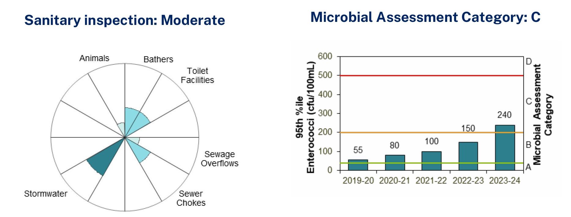
Shelly Beach, Source: State of the Beaches report 2023-24
Pittwater's estuarine beach swimming spots
Barrenjoey Beach
Barrenjoey Beach is approximately 1.5 km long and located on the north-eastern foreshore of Pittwater.
The Beach Suitability Grade of Good indicates microbial water quality is considered suitable for swimming most of the time but may be susceptible to pollution after rain, with several potential sources of faecal contamination. Those listed are again this year the Hawkesbury river, stormwater run-off and animals.
However, the report states the Enterococci levels generally increased with increasing rainfall, occasionally exceeding the safe swimming limit after little or no rain, and often after 10 mm or more.
This has increased in the most recent report - up to 185 compared to the previous report level of 165.
The site has been monitored since 1996.
Paradise Beach Baths
Paradise Beach Baths have again been rated a Beach Suitability Grade of Good, which indicates microbial water quality is considered suitable for swimming most of the time but may be susceptible to pollution after rain, with several potential sources of faecal contamination including stormwater.
Enterococci levels generally increased with increasing rainfall, occasionally exceeding the safe swimming limit after light rain, and often after 10 mm or more.
The site has been monitored since 1996.
Clareville Beach
Clareville Beach gets a Beach Suitability Grade of Good this year, which indicates microbial water quality is considered suitable for swimming most of the time but may be susceptible to pollution after rain, with several potential sources of faecal contamination including stormwater.
Enterococci levels generally increased with increasing rainfall, occasionally exceeding the safe swimming limit after light rain, and often after 10 mm or more.
Stormwater is rated the highest source of Enterococci contamination, followed by boats.
The site has been monitored since 1995.
Taylors Point Baths
The Taylors Point Baths is again rated a Beach Suitability Grade of Good, which indicates microbial water quality is considered suitable for swimming most of the time but may be susceptible to pollution after rain, with several potential sources of faecal contamination including stormwater.
Enterococci levels generally increased with increasing rainfall, occasionally exceeding the safe swimming limit after 10 mm or more of rain, and often after 20 mm or more.
Once again Stormwater is rated the highest source of Enterococci contamination, followed by boats.
The site has been monitored since 2010.
Bayview Baths
Bayview Baths has again been rated Poor. This indicates microbial water quality is susceptible to faecal pollution, particularly after rainfall and occasionally during dry weather conditions, with several potential sources of faecal contamination including stormwater and sewage overflows.
Enterococci levels generally increased with increasing rainfall, occasionally exceeding the safe swimming limit after little or no rain, and regularly after 10 mm or more.
Stormwater, sewage overflows and sewage chokes are listed as the highest sources of Enterococci contamination. Boats are listed as well. Here too, the amount of pollution has increased since last year's report.
The site has been monitored since 1995.
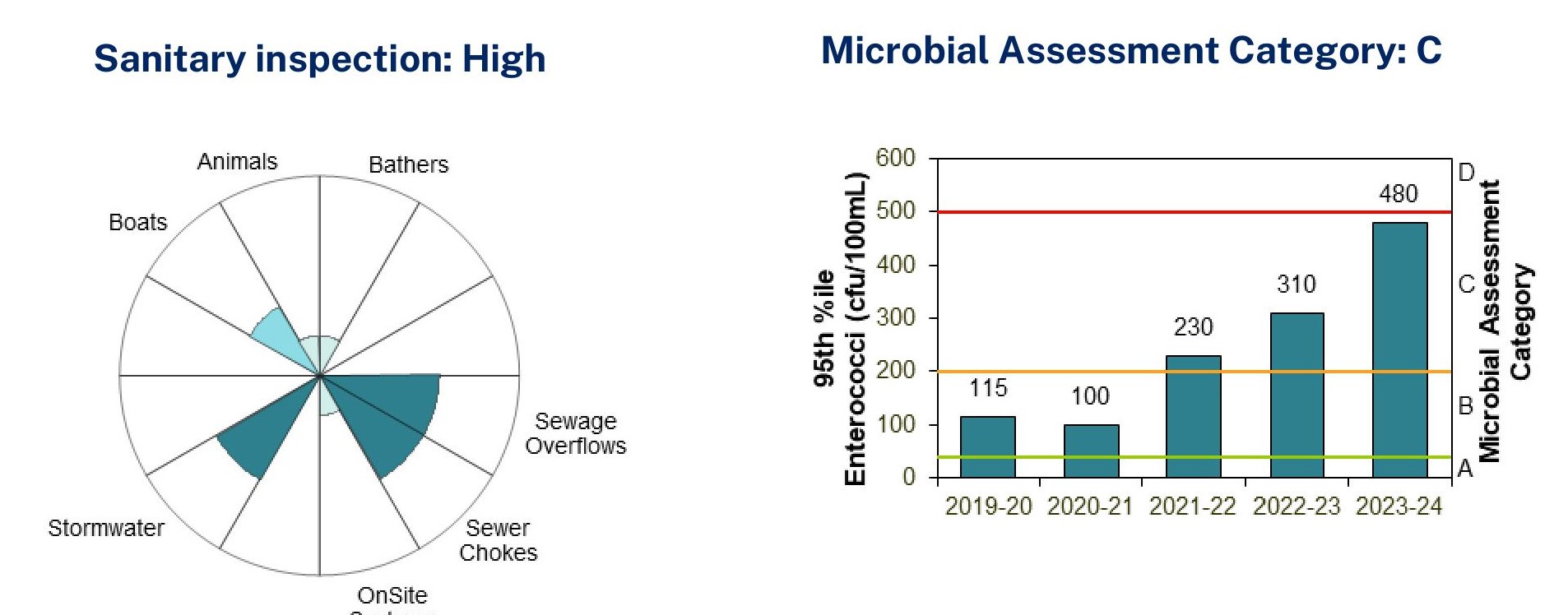
Bayview Baths, Source: State of the Beaches report 2023-24
Elvina Bay
Elvina Bay has received a Beach Suitability Grade of Good, which indicates microbial water quality is considered suitable for swimming most of the time but may be susceptible to pollution after rain, with several potential sources of faecal contamination, including stormwater.
Enterococci levels generally increased with increasing rainfall, regularly exceeding the safe swimming limit after 10 mm or more of rain.
The site has been monitored since 1995.
North Scotland Island
The North Scotland Island swimming site is a 15 by 50 m netted enclosure located on the north side of Scotland Island in Pittwater.
This has received a Beach Suitability Grade of Good this report, which indicates microbial water quality is considered suitable for swimming most of the time but may be susceptible to pollution after rain, with several potential sources of faecal contamination including onsite systems.
Enterococci levels generally increased with increasing rainfall, occasionally exceeding the safe swimming limit after 10 mm or more of rain, and often after 20 mm or more.
The site has been monitored since 1995.
South Scotland Island
The South Scotland Island swimming site is located at Carols Wharf on the southern side of Scotland Island. The location is not netted and is backed by a reserve.
The 2023-24 report rates this as having a Beach Suitability Grade of Good. This indicates microbial water quality is considered suitable for swimming most of the time but may be susceptible to pollution after rain, with several potential sources of faecal contamination including onsite systems.
Enterococci levels increased with increasing rainfall, often exceeding the safe swimming limit after 10 mm or more of rain.
The site has been monitored since 1996.
The Basin
The Basin remains a star in Pittwater's estuarine beaches with a Beach Suitability Grade of Very Good. This indicates microbial water quality is considered suitable for swimming almost all of the time with few potential sources of significant faecal contamination.
Enterococci levels generally increased with increasing rainfall, occasionally exceeding the safe swimming limit in response to 10 mm or more of rain, and often after 20 mm or more.
Pollution here is attributed to Bathers and Boats.
The site has been monitored since 1999.
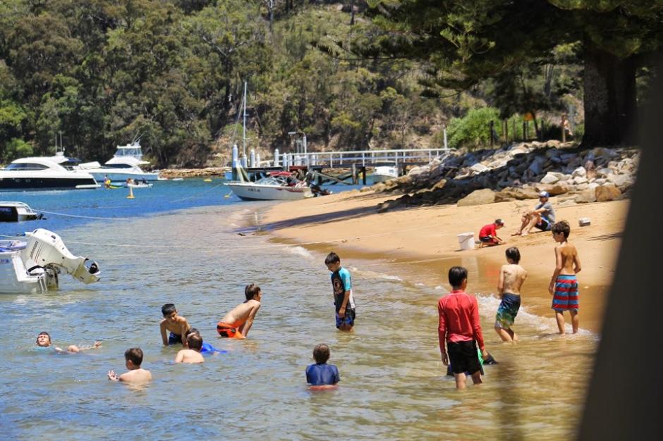
Great Mackerel Beach
Great Mackerel Beach has declined in this report. The Beach Suitability Grade of Good this year indicates microbial water quality is considered suitable for swimming most of the time but may be susceptible to pollution after rain, with several potential sources of minor faecal contamination.
The lagoon runoff and onsite systems are listed as the highest cause of Enterococci contamination.
Enterococci levels generally increased with increasing rainfall, occasionally exceeding the safe swimming limit in response to 10 mm or more of rain, and often after 20 mm or more.
The site has been monitored since 1999.
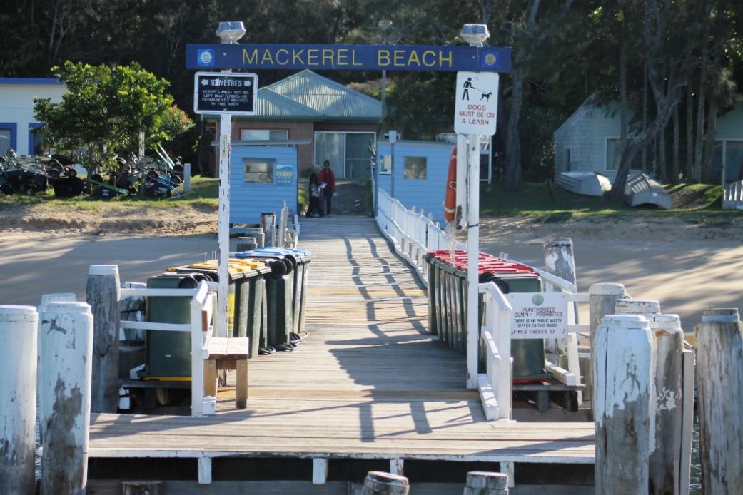
References
- Narrabeen Lagoon entrance sand removal works have commenced - September 2018
- Community News: August 2021
- Collaroy Seawall Prompts Calls For Residents To Join In Drawing A Line In The Sand - 2021
- Line In The Sand Demonstrators At Collaroy Sea Wall Call For A Better Solution Than Destroying This Public Beach - Dec. 2021
- No Sediment Barriers At Collaroy-Narrabeen Seawall Site: Surfrider Foundation Northern Beaches February 4th Video Of Runoff + Extension North Proposal - February 2022
- Community asked for comment on draft strategy for Narrabeen Lagoon management - May 2022
- Council Works To Open Narrabeen Lagoon Entrance Again: An Expense Recurring More Frequently - Extension of Wall North; Northern Beaches Council called an extraordinary meeting of the Northern Beaches Local Planning Panel (NBLPP) to be held at Council Chambers Dee Why, 725 Pittwater Rd on Monday 25th September at 10.30am. - 2023
- Narrabeen Lagoon Entrance Clearing Works: September To October 2023
- Pittwater Greens councillor calls for moratorium on seawalls - November 2023
- Narrabeen Lagoon sand removal completed ahead of schedule: berm at entrance removed - November 2023
- Narrabeen Lagoon Entrance Closed Again: Council's Update - February 2024
- Council Open Narrabeen Lagoon Entrance- February 2024
- State Of Beaches 2022-2023 Report: Mona Vale Beach Downgraded - Most Other Swimming Spots 'Good'
- Holding Back The Tide by Wendy Frew, The Coast, Radio Northern Beaches
- Narrabeen Lagoon And Collaroy Beachfront: Storms And Flood Tides Of The Past
- Pittwater, Narrabeen Lagoon & The Collaroy Beachfront: Some Storms and Flood Tides Of The Past - With Pictures
- Narrabeen Lagoon and Collaroy Beachfront: Storms and Flood Tides Of The Past + Collaroy Beach Reserve Gazettal
- Pittwater Roads II: Where the Streets Have Your Name - Narrabeen
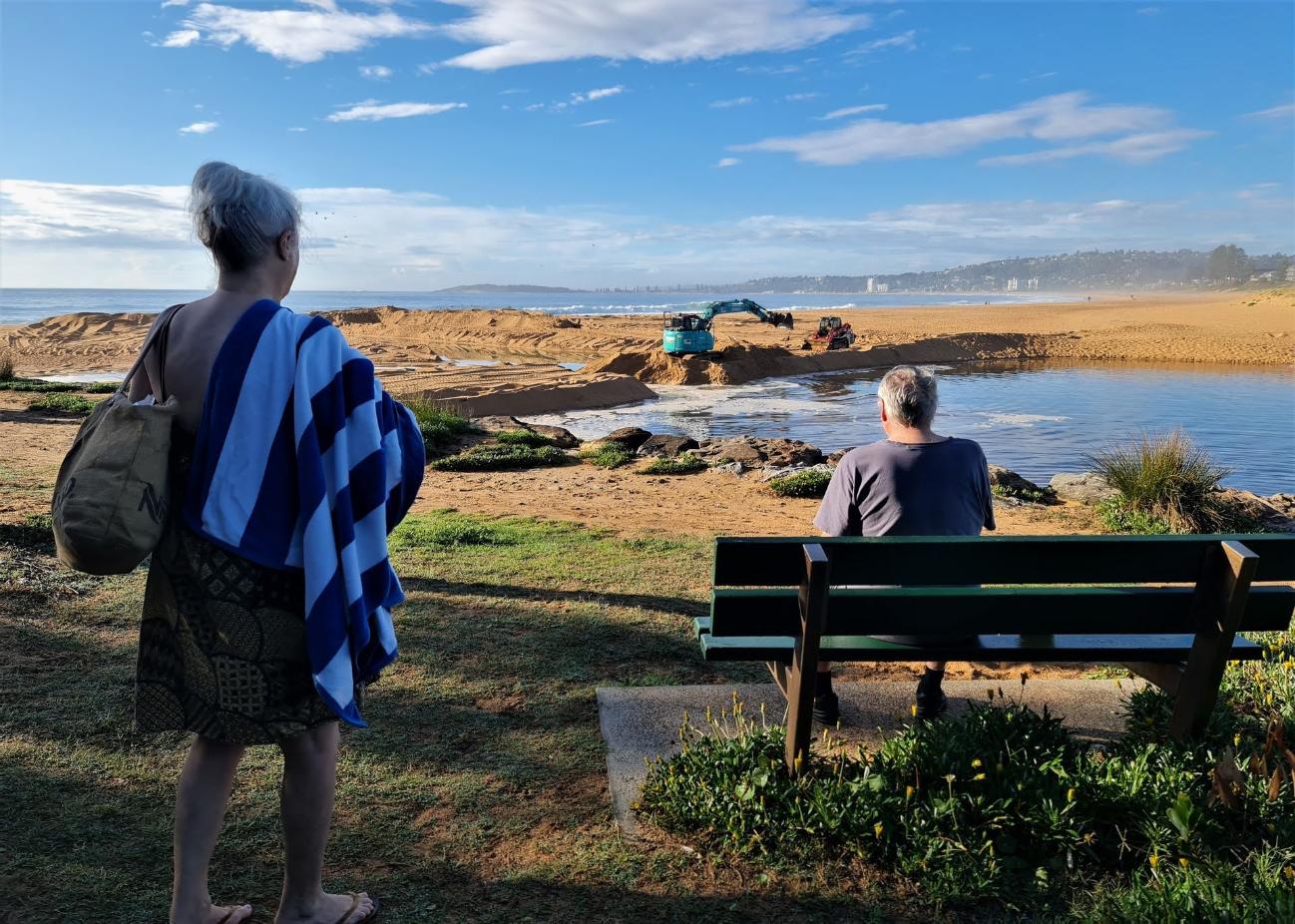
Narrabeen Lagoon entrance being opened again. Photo: Thursday November 30, 2023 by Joe Mills